Drawing Figsbury Ring

On this the last official day of the Wessex Hillforts and Habitats Project, we have reached the final of three hillfort imaginings crafted by illustrator Julia Lillo.

This last one is controversial.

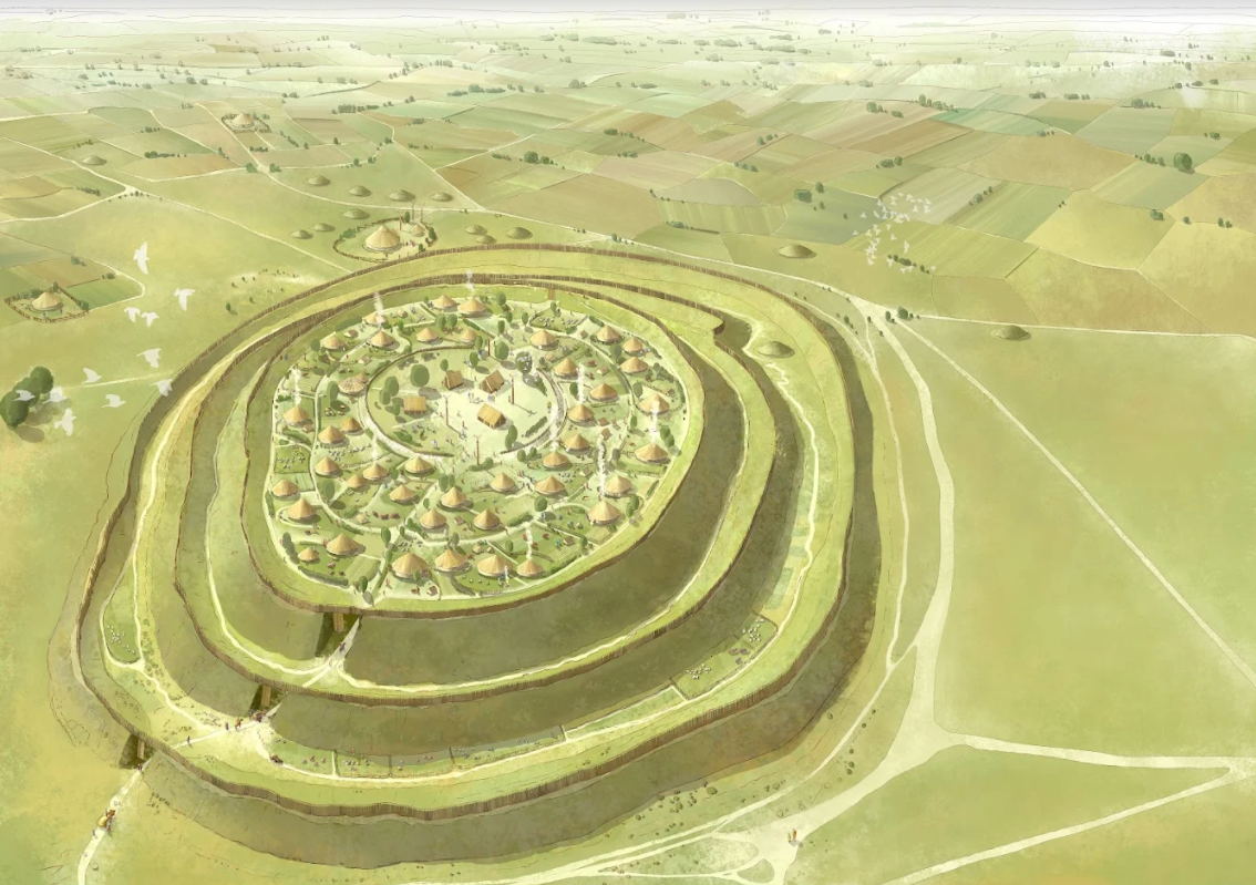
Figsbury Ring in Wiltshire lies east of Salisbury on a high spur of land looking back towards the city.

Figsbury Ring looking across the Wiltshire landscape

A single, near circular rampart with an outer ditch with opposing causewayed entrances through the defences.

This place is wierd because about 20m inside the rampart there is a wide ditch. This also has opposing causeways in line with the gaps through the outer rampart. Particularly curious because this ditch has no bank….so where did the soil go.

The Inner ditch at Figsbury. Sent today by project manager Marie McLeish

There were excavations in the 1920s when Neolithic pottery was found in this ditch, early Iron Age pottery found in the outer rampart ditch and a scatter of Early Bronze Age pottery across the site. No real evidence of round houses or pits…but in 1704 a later Bronze Age, broken bronze sword was found.

So, a place used over 1000s of years… but not really a settlement it seems. A geophysical survey showed no features to indicate that it was permanently occupied. Curious…. how to illustrate that?

I remember large events held in the park in front of Kingston Lacy House. Tents everywhere with all sorts of displays inside… representing all the various activities across the twin estates of Corfe Castle and Kingston Lacy. Thousands visited over several days but archaeologically, once the tent pegs had been removed, nothing was left behind…. apart from the odd coin in the grass.

Hillforts were not all used in the same way, some were permanently occupied settlements but others were created perhaps as secure stock enclosures or temporary or seasonal meeting places and/or markets. Occasionally, they were perhaps built for a specific military campaign or other purpose and then abandoned or reoccupied and modified at a later date…

LiDAR image of Figsbury Ring

so many possibilities…. and if tested against the narrative records of the New Zealand Maori and their hillforts.. all the reasons for their existence listed above were true for various sites across the North and South Islands as narrated in their histories.

So.. there were animal burials in the Late Bronze Age and Early Iron Age. Horned ox skulls are sometimes found within layered structured deposits as sacred deposits filling disused grain storage pits… alongside the skeletons of other animals and the odd chunk of human body.. or whole person.

They were like us in some ways but in most aspects of their lives, particularly in their belief systems…..they were very different in their outlook.

Animal sacrifice was a big thing. The Iliad and the Odyssey are full of the details of offering bulls to the deities. The gods got angry and needed proper sacrificial offerings… if they were to work their power in support of the mortals.

Enter Figsbury and you are cut off from the surrounding landscape. You are contained and feel led into the centre through the inner ditch causeways. What happened in there?

Celebrating a bull sacrifice to the Iron Age deities within the inner ditch.. imagined at Figsbury

For this drawing, I did a sketch and asked for an imagining of ritual based on the Ancient Greek writings of Homer about 800 BC.

On the rampart a wooden palisade but decorated with carved posts and over the gate skulls fixed on gateposts.

Imagining the gateway into Figsbury Ring

It is a creative view of what might have happened here. It gives an idea of a different vision of the world.

There are so many things we may never know about these ancient communities. Most is a vague misty landscape with occasionally an archaeological shaft of sunlight to make things a little clearer.

Julia’s completed picture of Figsbury. In this case a single round house, the place of the priest? against the rampart

In 1988 we excavated an ox burial dating to the Late Bronze Age deliberately buried in a deep inner ditch within an enclosure. We found two sheep burials nearby. Animal sacrifice was a thing. Whether it happened at Figsbury we may never know.

A later Bronze Age ox burial excavated in an enclosure ditch at Kingston Lacy

Look out for the Wessex Hillforts Booklet we’ll put a link to it on this blog when it is ready.

Drawing Park Hill Camp

As February comes to an end, so the Wessex Hillforts and Habitats Project also officially closes but this does not mean that the conservation work will cease.

Each of the 12 hillforts of the project will have a management plan which sets out funded actions that the ranger team and volunteers will carry out annually. This will ensure that each site will remain on top form for nature and archaeology.

And for visitors to these special places there will be the Wessex Hillforts Guide. Here is the second of Julia Lillo’s drawings which visualise what three of the hillforts may have looked like over 2000 years ago.

Park Hill Camp is on the Stourhead Estate in south-west Wiltshire… on the edge of Somerset and Wiltshire.

It is placed on the crest of a ridge between two valleys that funnel water into.. what is now the great 18th-century lake. The centre-piece of the internationally famous landscape garden created for Henry Hoare in the 1740s.

This is the source of the River Stour that flows through Dorset, past Hod and Hambledon hillforts, past Spettisbury and Badbury Rings to Dudsbury and finally to Christchurch Harbour and the Iron Age trading settlement of Hengistbury Head ….where the Stour finally flows into the sea.

Park Hill is nearest of three hillforts around the Stour’s source and its construction may be linked to a sacred and strategic significance. Perhaps the local Iron Age people revered this place where their great river was born. Something to wonder at… but who knows ?

It is a hidden hillfort. Not well known. The whole site was covered in pine plantations before the NT was given the Stourhead Estate in 1944. Now Kim is gradually unveiling the hillfort and grazing the site so that it can be a grass covered, better conserved and visible archaeological site.

This month’s storm blew another tree down just outside the west entrance.

The double ramparted enclosure of Park Hill Camp emerging from the trees after woodland clearance.

The initial woodland clearance was carried out by shire horses dragging the heavy trunks off site. Thus protecting the archaeology by preventing any rutting into the soft ground surface.. which heavy forestry vehicles might have caused.

Anyone inside Park Hill, has no sense of its position in the landscape. Everything is hidden by trees. NT plans to cut views through the conifer plantations towards the other Stourhead Estate hillfort on White Sheet Hill and across the valleys to north and south.

There should be spectacular views from here and the LiDAR demonstrates this.

Park Hill Camp on the summit of the flat ridge top between the two valleys with the Stourhead lake in the foreground fed by water funneled along the valleys.

So, with the trees stripped back by LiDAR I turned the terrain model to show the hillfort looking back towards the lake and Stourhead House.

After some rough sketching, I asked Julia to draw the view as it might have been in the Iron Age.

Park Hill Camp showing the double ramparts crossing the width of the ridge.

The difficulty with Park Hill Camp compared with Badbury Rings is….there has never been an excavation on the site and it has never had a geophysical survey. Very difficult with trees all over it.. Now the trees are largely gone we plan geophysics in the autumn.

However, we can see the earthworks and have a good idea of the entrances and can compare Park Hill with other hillforts where we have more information…so we’ll try to illustrate it anyway.

Julia’s east entrance into Park Hill Camp

The eastern gateways through the two ramparts are clear as earthworks. Visitors would have to weave their way into the hillfort in full sight of the guards. A good security check.

Once again, Julia has shown much detail within the hillfort. Fenced homesteads with stock enclosures, granaries raised on stilts, weaving frames, outhouses and people. Imagining a busy place full of life rather than a quiet area of grassland surrounded by woodland.

Then the full illustration with the fort in its landscape, farms and fields and meadows, trees on the steeper slopes.. crossed by tracks and pathways disappearing into the distance.

Illustration of Park Hill Camp for the National Trust Wessex Hillforts Guide by Julia Lillo

We’ll have a look at Figsbury Ring tomorrow.

Drawing Badbury Rings

A particularly enjoyable outcome of the Wessex Hillforts and Habitats Project ..was to complete a guide book which features each of the 12 hillforts of the project …plus the Cerne Giant.

Marie, our project manager made this happen,sourcing and co-ordinating all the text and images.

It is about to go online and to print.

There was some funding for reconstruction drawings.

Trying to imagine a place as it may have looked in the Iron Age is challenging but exciting ….the skills of a patient artist are essential

Who knows whether something looks right… using the available evidence….. until it is drawn.

Marie commissioned Julia Lillo to create two illustrations for the new guide book. One for Figsbury Ring and one for Park Hill Camp in Wiltshire. National Trust was also given permission to use Julia’s Badbury Rings drawing which had accompanied an article in Ancient History Magazine.

This reconstruction had used an air photograph taken over the east entrance of the hillfort.

Which was backed up by a LiDAR image of the earthworks.

I looked at the original drawing again..

We had carried out several excavations and geophysical surveys within the Badbury landscape. There were also many air photographs showing crop and soil marks of features below the ploughsoil.

So there was much we could show in the Iron Age view beyond the hillfort…It definitely needed some work.

I sketched out what I thought over the weekend and sent it to Julia.

She gave us a black and white line drawing and then there followed a conversation of sketches and alterations. Until the rough coloured image was created and eventually the final image.

Though it will be one image on a guide book page..Julia has shown a lot of detail that can be zoomed into.

Just beyond the west side of the hillfort is the site of the Iron Age temple site we excavated in 2000 with its enclosure around it. It has been imagined within an enclosure with totem poles with antlers on them.

The drawing shows the temple amongst the Bronze Age round barrows. Many are still large earthworks but other smaller barrows have been picked up using geophysical survey.

In the background are typical small ‘celtic’ fields of the Iron Age and a hut within an enclosure representing one of the many farmstead sites found in the Badbury landscape.

The drawing is crossed by trackways; some lying alongside the earthworks of later Bronze Age ‘ranch’ boundaries or ‘linears’ which divided up the landscape from about 1000 BC.

Inside the hillfort there are the sites of many round houses.. and as you walk round the hillfort, and get your eye in, their circular hollows can be seen terraced into the rounded dome of the hill top. Julia has shown walkways and palisades on the tops of the ramparts.

One Bronze Age barrow was included in the hillfort when the outer rampart was constructed. It is still a clear earthwork.

In 2004, when we excavated inside Badbury, we found grain and plant remains trampled into the floor of one of the round house hollows with pottery and oak charcoal dated to about 200 BC.

Julia has shown a busy hillfort settlement. The houses in small enclosures with outhouses, people and livestock.

A gateway leads to the ‘barbican’ enclosure. The middle rampart kinks out to create a space, perhaps a secure area for livestock.

Panning out, the drawing shows a circular area within the centre and highest point of the hillfort. Perhaps reserved for a special purpose. Sacred? or for a leader’s high status residence. There are traces of an early earthwork enclosure here though it has been disturbed by 18th and 19th century tree plantation banks.

Here is the whole drawing !

Around the hillfort, I suggested sheep and cattle pasture but on the better soils, towards the River Stour, there are small arable fields and farmsteads stretching into the distance.

The eastern Iron Age gateways through the three ramparts can be seen in the foreground.

The drawing is an interpretation to try to understand what life was like when Badbury was at its best, over 2000 years ago….. but new discoveries will provide fresh evidence which will enable us to draw a more accurate picture.

For example, the ramparts could be freshly made. They’d be bright white from the newly dug chalk bedrock hacked from the ditches.

Waipoua to Lambert’s Castle

John drove me in the Land Cruiser along the unmetalled track. We were getting ever higher, Pinus Radiata stretched out below us as far as the eye could see.

Waipoua Forest, Northland

A stony landscape.. of more angular slopes.. volcanic.. not like the smooth undulating downlands of home.

He parked in a forestry cutting in the trees, we took our cameras and began our climb through the dense foliage to the ridge top.

Back in the 30s, when they planted the trees, the woodsmen had written about some of the sites they came across. Today, we were going to rediscover one of these.

John turned and said. ‘In Maori this pa is known as blind man’s hill. People rarely come here now. There is a sense of tapu about this place..

He pushed past another branch and it flicked back.

‘Careful of your eyes Martin’ he said and intimated a sense of two worlds drawn together ….Maori and Pakeha. The first nation’s narrative of the landscape, all around, and particularly real, on this day, very far from anyone else…. in Northland’s Waipoua Forest

What an extraordinary job this was. To map the archaeology and to highlight the significant sites for protection… before the loggers moved in with their machines. Clearfelling the pine trees to take the crop.

The previous week, Jill and Kate had taken me north across the Rawene Ferry to 90 mile beach.. there to meet John and Gaby at Aupouri.

One of the midden sites we found on Ninety Mile Beach, Northland

We had walked amongst the dunes and seen the huge middens of shells mixed with fish and occasional whale bones, the food debris from Maori coastal communities, abandoned a few hundred years ago.

Kate found a bright greenstone/jade pendant resting on the surface of one white heap.

In the evening, in honour of the midden makers, we collected tuatua shell fish and cooked them over a fire as the sun set over the Tasman Sea.

Most of my employment occurred deep within the pinelands or native bush, walking the forestry compartments, from the Waipoua river up to the valley edge.

I lived in a hut within the Forestry base. Each day, before setting out, I wrote the date and my destination and left it on the table (health and safety). Then out on the trail bike with a back pack and the map.

To be honest they hadn’t mapped it all in 1980. The contours stopped on a blank line and I had to rely on a few black and white aerial photos to plot my location.

Waipoua Forest Service HQ

So there I was, out amongst the trees and streams with a couple of fantails flitting from twig to twig, taking advantage of the insects I disturbed in my progress through the totara, rimu and nikau.

Aileen Fox had spotted the similarities. Though the Maoris had no pottery or metal, their hill top pa and kumara/sweet potato storage can be compared with Britain’s Iron Age hillforts and grain pits.

The Maori were great agriculturalists. Down by the river floodplain there were overgrown drainage channels and heaps of stone faced mounds for taro and kumara propagation. Higher up the valley, I would break through the trees onto a spur of land and find a string of playing card shaped pits and a couple of terraces for huts. These were for storage of their produce and the Victorian explorers drew the little pitched flax-roofed structures, constructed to keep the root vegetables frost-free and dry.

The Maori discoverers of New Zealand had brought the kumera by boat from warmer polynesian climes and they needed protection to flourish.

Then on the ridge tops, occasionally, a defended settlement or pa. Some had ramparts, many had a series of terraces, the outer enclosures defended by wooden palisades and within, a scatter of rectangular timber framed buildings.

What a shame we don’t have the sketches of Roman traders and soldiers to show us what Hod Hill, Hambledon or Badbury in Dorset would have looked like.

There are many early 19th century sketches surviving in Auckland library. It’s where I spent some time writing the survey report once I had returned to city life.

Kaitote pa Taupiri, Waikato, drawn by G.F. Angas 1845

By the 1800s, the Maori had mixed their culture with the advantages and distresses of the Europeans. Muskets replaced the Meri and Patu and gun pits were dug into their hillforts.

So, over 40 years later, I often think of the Waipoua valley…. stumbling out of the forest onto the beach. The day we found glittering paua shells in the rock pools and the visit to the valley kainga settlement where the Maori foresters and their families lived above the home sites of their forefathers.

In imagination, my 90 mile beach is Studand, though you would need to go to Cleaval Point or Fitzworth on the north Purbeck shore to find the Iron Age cockle shell middens…

And for Waipoua, the angular and flat-topped hills of West Dorset. The pa sites of Pilsdon, Coney’s ….and particularly Lambert’s Castle.

RCHM plan of the earthworks at Lambert’s Castle. The Iron Age hillfort was later used for an annual fair and a horse racing track was created on the hilltop to the south of the hillfort. The tree fell in 1990 ripping up the rampart and ditch a little south of C-C, top left of the hillfort circuit. A military signalling telegraph was erected here in the 19th century. Part of a chain of signals stretching from Exeter to London.

Much of Lambert’s Hill is covered in trees and reminds me of that walk up with John to ‘Blind Man’s Hill’.

This week’s storms take me back to 1990 when some of Lambert’s trees tumbled and one tore up the rampart of the hillfort. Michael and I spent the summer cleaning up the section and drawing the layers making up the defensive bank and the silted outer ditch.

Section drawing across the rampart and ditch of Lambert’s, where the tree fell during the storm of January 1990. I wonder where trees have fallen this stormy weekend February 18th-20th 2022.

In West Dorset, the soil is acid like Waipoua; bone does not survive, and like the people of Northland, there was no pottery at Lambert’s, just the layers of sand and stone used to construct this high fort looking across to Golden Cap and the Channel, high above the Marshwood Vale.

Our only find, a 19th century beer bottle, probably tossed against the bank by someone celebrating at the annual Lambert’s Castle fair and horse racing event which continued there each year right up to the mid 20th century.

At Waipoua Kiwinui pa, we came across a single flake of jet black shiny obsidium, scuffed up from a forestry track.

Pa site Kiwinui where the obsidium flake was found

As Kate held this exotic object, I thought of England and the worked flint, scattered across the fields of the chalklands many 1000s of miles away.

We ambulated these mountain tops for seven miles, when suddenly the deep valley of Waipoua opened to our view, in the centre of which a large native settlement appeared. The valley was irrigated with a stream of water. We had a mile still to walk before we reached the kainga, but were no sooner seen winding our way down the hills, than we could hear the distant shouts resound through the valley, and a distant discharge of muskets commenced to greet our arrival.’ J.S. Pollack, 1838