File:Composite map Pinus cembroides + Pinus johannis + Pinus remota (Pinus cembroides sensu Little 1966).png

From Wikimedia Commons, the free media repository
Jump to navigation Jump to search

Original file(1,003 × 1,160 pixels, file size: 25 KB, MIME type: image/png)

Captions

Captions

Add a one-line explanation of what this file represents
Description
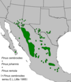
English: Composite map of Pinus cembroides + Pinus johannis + Pinus remota (= Pinus cembroides sensu E. L. Little 1966).
Date
Source Adapted from USGS Pinus cembroides map
Author E. L. Little in Critchfield, W.B., and Little, E.L., Jr., Geographic distribution of the pines of the world
Permission
(Reusing this file)
Public domain
This image is a work of the Forest Service of the United States Department of Agriculture. As a work of the U.S. federal government, the image is in the public domain.

File history

Click on a date/time to view the file as it appeared at that time.

Date/TimeThumbnailDimensionsUserComment
current22:24, 30 September 2013Thumbnail for version as of 22:24, 30 September 20131,003 × 1,160 (25 KB)MPF (talk | contribs){{Information |Description ={{en|1=Composite map of ''Pinus cembroides'' + ''Pinus johannis'' + ''Pinus remota'' (= ''Pinus cembroides'' sensu E. L. Little 1966).}} |Source =Adapted from [http://esp.cr.usgs.gov/data/little/ USGS] [http://esp...