PIECES, PATTERNS, & PROCESSES:
an ecological assessment of Hurricane Island, Maine

prepared by : Benjamin Lemmond
m . s . candidate field naturalist program the university of vermont
may 2016

prepared by : Benjamin Lemmond
m . s . candidate field naturalist program the university of vermont
may 2016
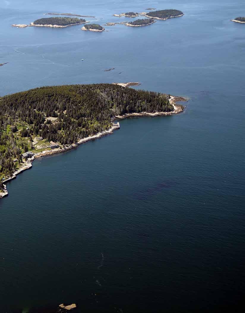
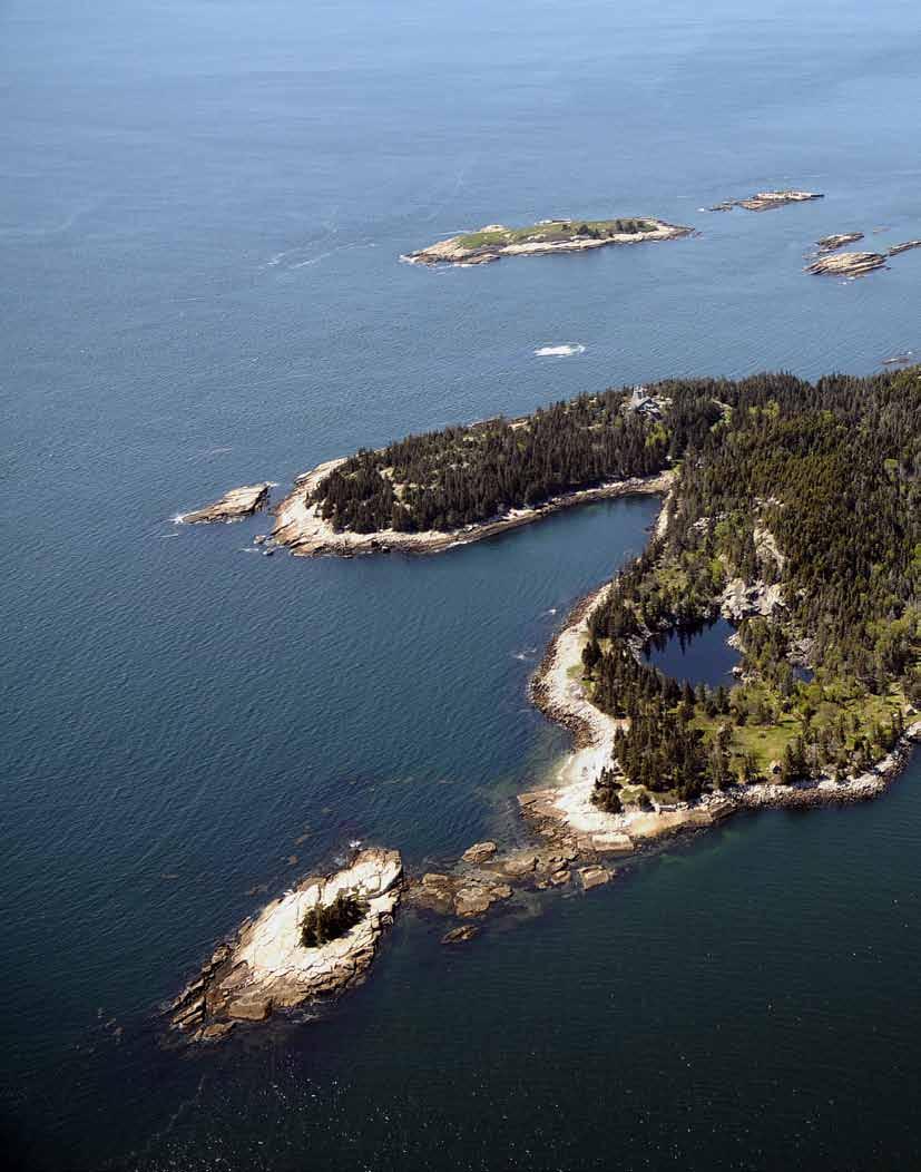 Aerial photograph of Hurricane Island courtesy of HICSL
Spending a summer on Hurricane Island was the priviledge of a lifetime. I am deeply grateful to all of the committed, creative, and spirited employees (both on and off-island), board members, interns, community members, visitors and volunteers who make the Hurricane Island Center for Science and Leadership possible. I am especially grateful to Cait Cleaver for her oversight and support throughout this process. Sam Hallowell, Pheobe Jekielek, Jenn Page, Oakley Jackson, Josie Gates, Micah Conkling, Alice Anderson, and Chloe Tremper were all incredibly gracious and helpful in integrating me into the everyday functions of the island and taking the time to lend me their own knowledge, experiences, and the occasional boat ride.
I could not have asked for a better support team on the Vermont side, including my advisor, Dr. Jeff Hughes, and committee members Dr. David Barrington and Dr. Josef Gorres. Their thoughtful comments, questions, and insistence on quality made this project a piece of work I am proud of. Their sincere interest in my professional and academic development is a gift whose value is beyond measure.
In the summer of 2015, I conducted an ecological assessment of Hurricane Island, a 125-acre island in the West Penobscot Bay of Maine. As part of this assessment, I surveyed plant species, natural communities, soils, geologic features, and the impacts of human settlement on Hurricane Island. I also researched the ecological and human history of the Penobscot Bay region.
As a graduate student in the University of Vermont’s Field Naturalist (M.S.) Program, I drew from the program’s unique approach to landscape assessment in designing this assessment. This approach emphasizes the importance of finding explanations for patterns observed in a landscape, in addition to using traditional field techniques to identify its individual components. In other words, while my assessment involved surveying the individual pieces of the island’s ecology – plants, animals, natural communities, etc. – my ultimate goal was to provide explanations as to why these pieces appear in certain patterns observed on Hurricane Island, and describe the key processes involved in shaping the island’s ecology.
I identify four forces that shape landscape patterns on Hurricane Island: geology, glacial activity, climate, and human history. This report begins with an account of how these forces influence ecological patterns on Hurricane Island. Key points covered in these sections include:
» The formation of granite was relevant to the placement of Hurricane’s granite quarries
» Granite bedrock is the common denominator of many Maine islands, and has a strong influence on the plant communities in the region
» Glacial activity helps explain coarse-scale patterns Hurricane Island’s topography
» Sediment deposits on Hurricane Island’s north beach are directly connected to fluctuations in Maine’s sea level
» Hurricane Island is located at an important biogeographic “tension zone” where range limits of many plant, bird, and insect species converge
» As a result of climate change, winter precipitation is predicted to increase but summer precipitation is expected to decrease, possibly increasing the risk of fire
» Intense storm events and sea level rise are both predicted to increase along the Maine coast in the next century
» Major ecological changes resulting from human settlement on Hurricane Island includes species introduction (raccoons, earthworms, and nearly 40% of Hurricane’s plant species), new habitat created such as freshwater ponds, and landscape patterns established and maintained since the quarry-town era (1870-1914)
» Individual species regeneration niches (e.g., white spruce compared to red spruce) help explain the persistence of certain landscape patterns over time
Subsequent sections summarize the results of the field survey, including species lists of major taxa, natural community delineations and descriptions, soil pit analysis, and a description of the island’s spruce-fir forest. Highlights from the survey include:
» Four natural communities were identified on Hurricane Island, including: Low-Elevation Spruce-Fir Forest, Maritime Spruce-Fir Forest, Red Spruce-Mixed Conifer Woodland, and Rose-Bayberry Maritime Shrubland. These natural communities are all common in the state.
» Of the 148 vascular plant species identified on Hurricane Island, 41 (28%) are introduced. Hurricane only has one individual of an invasive species, a lone Morrow’s Honeysuckle (Lonicera morrowii) near the shower house. Removal of this plant is recommended. Beach rose (Rosa rugosa) and Canada thistle (Cirsium arvense) are both listed as “potentially invasive” in Maine, but their removal is not feasible or recommended.
» Checklists for birds, mammal species, “herps” (reptiles and amphibians), and non-native earthworms were generated from a combination of fieldwork and synthesis of data collected previously on Hurricane Island.
» Hurricane’s soils are generally of three types: very thin, very acidic sands on hills and ridges; moderately acidic loamy sands in valleys and flat areas; and one small patch of marine clay under the sandy beach on Hurricane’s north end.
A final section contains suggestions for preserving the island’s cultural and ecological integrity, including:
» Systematically organize and update natural history observations on Hurricane Island
» Work with the Maine Historic Commission to develop a historic preservation plan for Hurricane Island
» Develop a system for recording archaeological findings on Hurricane Island
» Prevent soil erosion wherever possible
» Gather information and management perspectives on the low-elevation spruce-fir forest community, which appears to be dying in large patches on Hurricane Island
» Remove (one) invasive species present on Hurricane and participate in regional monitoring of invasive species
» Remove old HIOBS tent platforms that present a hazard
This project establishes the first comprehensive documentation and analysis of the island’s terrestrial ecology. Despite my attempt to make this survey as comprehensive as possible, there are many aspects of the island’s ecology that merit further exploration. Continued scientific investigation, whether by researchers or students, will undoubtedly add to and improve the understanding of the ecology of Hurricane Island as outlined by this document. Recommendations for future studies include:
» Monitoring spruce mortality, and investigating for similar patterns observed elsewhere in the mid-coast region
» Monitoring fog pH on Hurricane Island and frequency of fog events
» Monitoring of spruce budworm populations
» Studying the effect of the influence of understory species on the regeneration of canopy gaps and forest edges
» Inventory of Hurricane Island’s breeding amphibian population
» Regular inventory of breeding bird population and use of Hurricane Island’s natural communities
Other recommendations are included as an appendix to this assessment, as is a complete species list of vascular plants identified on the island.
Note: This project was completed in partial fulfillment of the requirements of the Field Naturalist (M.S.) graduate program at the University of Vermont.
Two
In the spring of 2015, the Hurricane Island Foundation, which operates the Hurricane Island Center for Science and Leadership (HICSL), invited me to conduct a formal ecological assessment of the island. As a graduate student from the University of Vermont’s Field Naturalist (M.S.) program, I used the Field Naturalist approach to landscape assessment where multiple layers (geology, soils, vegetation, wildlife, etc.) are studied individually and then synthesized into an account of the processes at work.
This report begins with an account of the four main drivers of change (granite, glacial history, climate, and human history) that were identified over the course of the fieldwork. Each of these four sections begins with an overview of the topic followed by a more detailed exploration of where, how, and why these affect the landscape. Additionally, the Climate section contains, as a second sub-section, an overview of scientific literature addressing how climate change may affect terrestrial ecosystems of the mid-coast region of Maine.
With this foundation in place, subsequent sections summarize the results of the inventory of the island's soils, natural communities, spruce-fir forests, and wildlife. In the final section of this report, "Protecting Hurricane's Resources" I recommend a few actions that the Hurricane Island Foundation can take to protect the island's natural and cultural resources.
Species lists and ideas for future student projects, citizen science, and scientific research are included as appendices to this document.
In-text and figure caption references are indicated with a superscript numeral and cited in full at the end of each section. Citation numbers restart with each section, figure numbers do not. Except where otherwise indicated, all photographs used in this report were taken by the author.
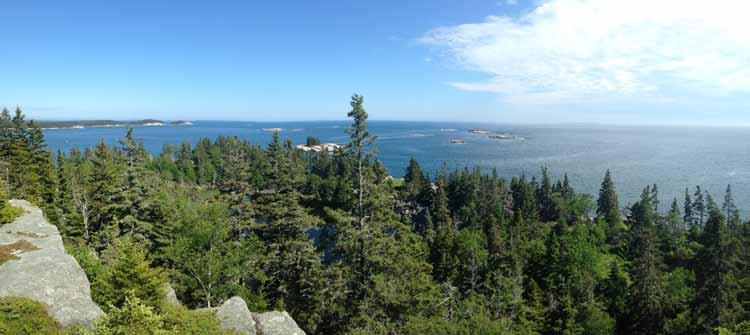
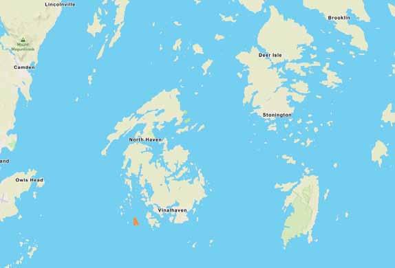
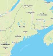
Hurricane Island is a small, approximately 125-acre island located in the Fox Island archapelago in the Penobscot Bay, Maine. The Fox Islands are comprised of two large islands, North Haven and Vinalhaven, and numerous smaller islands. Hurricane Island is approximately two miles southwest of Vinalhaven, and approximately twelve miles southeast of Rockland, the nearest mainland port city.
The history of the island as a quarry and company town from 1870-1914 is well known by locals, as is the island's decadeslong connection with the Outward Bound organization, which operated a base camp here for nearly 50 years before relocating to the mainland in 2006. Since 2009, Hurricane Island has been home to the Hurricane Island Center for Science and Leadership (HICSL), a 501(c)-3 science education, leadership, and research organization which hosts student groups, scientists, and leadership events at its sustainable, off-the-grid facilities on the island. The island's owners also maintain a residence on the restricted-access southwest peninsula.
The Hurricane Island Center for Science and Leadership (HICSL) was founded in 2009 with the mission to "create and preserve an open and sustainable island community that supports and enhances the educational opportunities of youth from Maine and beyond." Due to its remote location, HICSL's facilities are designed to operate completely off-the-grid. Sustainable infrastructure includes a solar array, a freshwater filtration and storage system, and composting toilets.
Granite bedrock is the common denominator of most islands in the mid-coast region. Granite is resistant to weathering and therefore provides essential plant nutrients at a slower rate, limiting the plant and animal communities that can survive on granite substrates. On the Maine coast, the quarrying of granite during the 19th and 20th centuries changed the physical landscape and brought thousands of workers to the region, fundamentally altering the cultural and ecological landscape.
This section provides an overview of Hurricane Island's geology in the context of the Maine coast and describes the physical and chemical properties of granite. General ways that these qualities influence plant life on the Island are discussed; the impacts of granite quarrying, however, are covered in the Human History section.
Key points:
» Hurricane’s granite is part of a single columnar mass (the Vinalhaven pluton) that makes up Hurricane Island, Vinalhaven and the other Fox Islands except North Haven
» The Vinalhaven pluton formed approximately 420 million years ago, far away from the North American continent, and was added to the continent during the Acadian Orogeny
» Granite weathers into blocks in cool, wet climates, and is rounded by wave action
» Structural differences in granite formations on Maine islands influenced the placement of quarries
» Granite bedrock weathers slowly and is impermeable to water, two conditions which affect plant communities
Hurricane Island’s bedrock is only one exposed tip of a much larger column of granite (and associated rock types) that measures about eight miles wide at the surface and extends several miles belowground. This column forms the bedrock of Vinalhaven, part of North Haven, and all of the smaller Fox Islands (see Figure 1). These columns are called plutons, after Pluto, the Greek god of the underworld (they may also be called batholiths). Other circular island groups in the Penobscot Bay reflect this columnar pattern in granite formation.
Earlier estimates of the exact age of the Vinalhaven pluton differ from more recent estimates by 80 million years2, but the most recent published data suggest that the pluton formed during the Silurian period, around 420 million years ago (MYA) – making Hurricane’s bedrock about as old as the first fossils of vascular plants.3 The revised estimate of the Vinalhaven Pluton’s age makes it the same age as Cadillac Mountain on Mount Desert Island.
Part of the reason why exact aging is so elusive is that the origins of this region’s rocks are highly variable, more of a mosaic of different rock types with some general themes than an orderly layering of geologic units. In the mid-coast region alone, there are over 100 granitic plutons with estimated formation ages ranging from the late Silurian (420 MYA) to the early Carboniferous (350 MYA).4 These plutons are embedded (or “intruded”) in rocks of varying ages: for
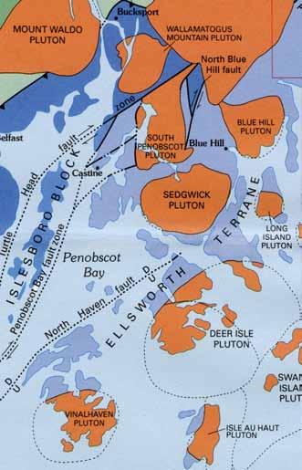
instance, meta-sedimentary rocks from the Precambrian era (>1 billion years ago) are found on nearby North Haven, adjacent to the Vinalhaven pluton. Because of their resistance to erosion, granitic plutons form a large majority of the prominent, exposed bedrock features, surrounded by other rock types of varying ages. Figure 1 shows the locations of major plutons in the Penobscot Bay.
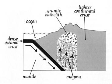
There are two general categories of igneous rocks: extrusive and intrusive. Extrusive volcanics form when magma erupts and is changed by contact with the ocean or air. Intrusive igneous rocks form beneath the surface.
Granite is a common intrusive igneous rock, named after the crystalline grain produced by its slow cooling process. Granite forms in large, often columnar chambers, which are at times repeatedly infused with magma (Figure 3). Due to the visibility of distinctive features of granite’s formation, the Vinalhaven pluton is often cited and studied as an ideal field location for understanding plutonic processes such as the repeated infusion of magma into chambers6,7,8.
Though there are many types of granite, the formation of its component crystals follows a general pattern. As the molten rock cools, the heavier, darker-colored minerals like mica, feldspar and hornblende are the first to coalesce in to crystalline structures.2 These crystals tend to be the largest, as they were the least crowded during their formation. Lighter minerals such as quartz cool last and therefore form smaller, less orderly crystals that fill the remaining space. Granite
can take on pink, orange, or grey hues depending on its specific mineral content.
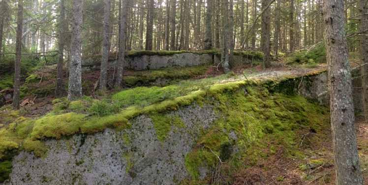
Granitic plutons form under extreme pressure from the bedrock above. As that bedrock is eroded away, however, much of that pressure is relieved, allowing granite to expand. This expansion creates cracks in the grain, also known as expansion joints. These cracks follow the contour of the batholith dome, creating curved layers that resemble layers of an onion, even in the way that the layers are thinnest near the top and thicker towards the core. As they are exposed on the surface, these layers appear as horizontal or gently curving sheets. The stairstep pattern formed by expansion joints in
morphic warping. This collision, which began about 360 MYA, was part of the process that brought the continents together in the formation of the ‘supercontinent’, Pangaea.
the Vinalhaven pluton on Hurricane Island is apparent on the forested slopes of the island (Figure 2).
Natural weathering causes those sheets to split along their horizontal seams (the “lift”) and again on vertical planes (the “rift”).5 These block-like formations are especially visible on the exposed coastline.
The Vinalhaven Pluton, for at least the first 50 million years of its existence (assuming an origin around 420 MYA), was far from the Maine coast. This pluton, and other rocks like it now found in Maine, belonged to a volcanic island group known as the “Avalon microcontinent” (or, alternatively: Avalonia or the Avalon Composite Terrane). This microcontinent drifted through an ancient ocean for millions of years before colliding, catastrophically, with the coast of ancestral North America (then, Laurentia). Much of the bedrock along the New England and Canadian Atlantic coastline, from Cape Cod to Nova Scotia, are the remains of this ancient island group that were added to the continental plate in this collision.9
This collision, known as the Acadian Orogeny, precipitated a major reshaping of the North American landscape. The Acadian Orogeny added landmass to the eastern seaboard, instigated major volcanic activity, metamorphosed existing rocks, and uplifted and further deformed the northern Appalachian mountain ranges. The rocks that were added to the Maine coast as well as those along the margins of the collision show a high degree of volcanic activity and meta-
Around 245 MYA, however, Pangaea began to split apart. North America and Europe divided the landmass of the Avalon microcontinent, forming the Atlantic Ocean in the process. Today, parts of the Avalonian microcontinent can be found in parts of Ireland, Germany, and Wales as well as the New England coast and Canadian Maritime provinces.
The impermeability of granite to water results in a juxtaposition of extremes: exposed rock surfaces with little to no soil that do not retain any water, and bedrock depressions where water collects and plant life must survive saturated conditions. The soils on the island vary (see Section V) but are generally shallow on the island’s slopes and well-drained loamy sands in depressions and swales.
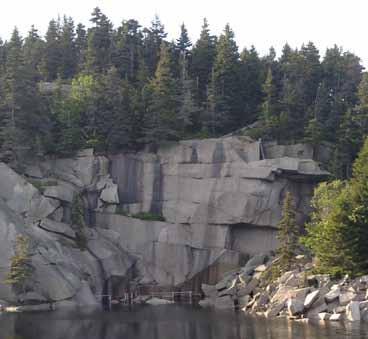
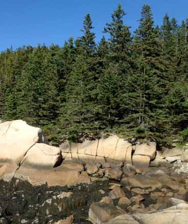
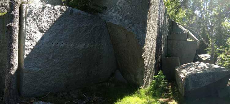
Hurricane has many exposed outcrops, notably the quarry face and summit, sunset rock, the sloped northern face of sunset hill, numerous small areas on the western slope, and rocks exposed along coastal areas, such as Gibbon’s point.
Plants in these exposed outcrops have to adapt to a number of harsh conditions, including: high solar radiation, high evaporative rates and desiccation risk, little to no soil, large fluctuations in temperature, few available nutrients, lack of physical stability, and greater exposure to wind and, along the coast, waves. Life forms found on Hurricane that are most successful under these conditions represent a variety of adaptations.
Lichens: symbiotic partnerships between fungi and algae (and cyanobacteria) combine the ability of fungi to dissolve rock and release nutrients and the ability of algae and cyanobacteria to fix atmospheric carbon through photosynthesis. Many lichens are cryptobiotic, meaning they can survive long periods of zero metabolic activity and resume functioning when favorable conditions return.
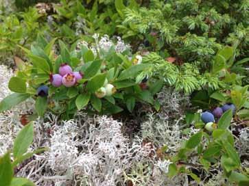
Heath shrubs: a group of plants that include familiar plants such as blueberry, cranberry, lingonberry (all members of the Vaccinium genus), huckleberry (Gaylussaccia/ Vaccinium sp.) and black crowberry (Empetrum nigrum). All of these plants belong to the heath family, Ericaceae. Heath shrubs are generally associated with acidic soils, high metal concentrations, and either extremely low or extremely high water availability (i.e., dry outcrops or permanently saturated soils). Many adaptations contribute to heath shrubs’ tolerance of harsh environments. Associations with a group of mycorrhizal fungi specific to this plant family (ericoid mycorrhizae) greatly improve the host plants’ tolerance of metal concentrations and increase access to nutrients. Leaf litter of many heath species contains high amounts of phenolic compounds that may suppress the growth of other species. Many of these plants reproduce asexually as well as sexually, facilitating dominance of extensive areas by heath species in favorable conditions.
Stunted growth: As a general observation, plants in exposed outcrop areas tend to be either low-growing as a habit or stunted versions of the plant’s “normal” growth form. Along the coast, for example, low and/or creeping forms of spruce (Picea spp.) and juniper (Juniperus communis) are common, as well as numerous plants that are low-growing by habit (e.g. Juniperus horizontalis, Empetrum nigrum, etc.).
Stunted black and red spruce (P. mariana and P. rubens) are found along exposed upland outcrops. As an adaptation to exposed areas, stunted growth reduces vulnerability to wind damage and/or creates a favorable microclimate
A few of these areas are described in the Natural Communities of Hurricane Island section of the report. In particular, see variants in the Low Elevation Spruce-Fir Forests and Mixed Conifer Spruce Woodland description.
Water collects in numerous bedrock depressions at the bases of Hurricane’s slopes. There are, additionally, a few small depressions along the hillsides, a few of them caused directly by quarrying. The most extensive saturated zone is in a bedrock depression on the northern slope of the island. A small dip in the bedrock on the island's northern slope is responsible for a distinct transition in the vegetation from the typical spruce-fir forests to a spruce-dominated area where cinnamon fern (Osmundrastrum cinnamomeum), threeseeded sedge (Carex trisperma), and peat moss (Sphagnum spp.) grow in abundance beneath a canopy of Red spruce (Picea rubens) (with some intermixing of black spruce, P. mariana). Small openings between the root network of the spruce trees reveal saturated peat beneath. These species are all typical of saturated, acidic, oxygen-poor substrates. This variant of the typical Low Elevation Spruce-Fir Forest is discussed in the Natural Communities of Hurricane
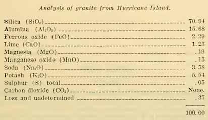
The first minerals to form in a cooling pluton - the micas, feldspars, hornblendes - are also the first to weather once exposed to surface conditions. These are, generally speaking, the darker flecks within the granite crystal matrix, and they also happen to contain some essential plant nutrients such as potassium, calcium, and magnesium. Granite, however, only contains a small proportion of those minerals. The majority of the granite matrix is quartz, or silica (SiO2): this mineral crystallizes at lower temperatures (i.e., is the last to form in the cooling pluton), and is therefore the most resistant to weathering at surface conditions. The relatively high resistance to weathering makes granite ideal for buildings and monuments; however, for other life forms who must obtain basic mineral resources from the soil or bedrock, its stubbornness as a raw material makes the granite landscape generally one of hardy habitat specialists.
These scant minerals can be dislodged from the crystal matrix by chemical and/or physical weathering. Chemical weathering involves the use of acids to attack chemical bonds in the mineral matrix. Rainwater contains dilute acids, but more concentrated and effective acids are secreted by a number of life forms such as lichens and fungi, plants, and a multitude of marine organisms.
Water also is a force of chemical erosion of granite, where
the mineral components of granite are dissolved until only quartz remains. This process is quite evident on any exposed coastline, where channels worn by water weave through the rock. As cracks worn in the granite by chemical erosion grow deeper, freezing and thawing water can split large portions of granite vertically, resulting in roughly right-angle block fracturing of granite. This, however, is a phenomenon par-
ticular only to coastal areas and other wet climates. Hot and dry climates, by contrast, weather granite into spherical shapes, as weathering is accomplished not by etching and splitting but by the differential expansion rates of minerals in the granite matrix as it is heated and cooled by the climate. This force is sufficient to force the granite apart radially over time. (Tom Wessels' Granite Landscape is an excellent treatment of this topic, and granite ecosystems in the US more generally - see citation at the end of this section). This rounded shape, though, is certainly found on Hurricane, by perhaps the fastest natural weathering process of them all: the constant tumbling and abrasion resulting from wave action. Rounded cobbles are found all along the coastline, but especially along the more exposed south and southwestern shores.
The quarrying of granite by humans mimics in some ways the block fracturing of granite by water. Of course, quarrying is more precisely and selectively done, but nonetheless relies on making small incisions in the rock along the vertical grain and then fracturing it with expansive pressure. In this case, hammers, wedges, and iron shanks are used in place of water and ice. If the vertical cuts are placed skillfully, and the thickness of the granite sheets formed by the expansion joints fits the desired depth of the rough blocks to be hauled off the quarry face, additional horizontal cuts are unnecessary. Therefore, determining the depth of these layers and the angle of the grain were very important considerations for quarry operators, and weighed heavily in the placement of quarries along the Maine coast.
Works Cited
1. Stewart, D. B. (1998). Geology of Northern Penobscot Bay, Maine. U.S. Geological Survey.
2. Gates, O. (2001). Bedrock Geology of North Haven and Vinalhaven Islands (No. Open-File No. 01-373) (p. 28). Mane Geological Survey.
3. Hawkins, D. P. (2002). Silurian U-PB zircon dates from the Vinalhaven intrusion and associated volcanic rocks, Penobscot Bay, Maine. Poster abstract presented at the Geological Society of America Annual Meeting, Denver, CO. Retrieved from https://gsa.confex.com/gsa/2002AM/finalprogram/abstract_46280.htm
4. Hogan, J. P., & Sinha, A. K. (1989). Compositional variation of plutonism in the coastal Maine magmatic province: mode of origin and tectonic setting. In Igneous and Metamorphic Geology (Vol. 4, pp. 1–33). Maine Geological Survey.
5. Wessels, Tom. The Granite Landscape: A Natural History of America’s Mountain Domes, from Acadia to Yosemite. The Countryman Press, Woodstock, VT. 2001.
6. Wiebe, R. A., Manon, M. R., Hawkins, D. P., & McDonough, W. F. (2004). Late-Stage Mafic Injection and Thermal Rejuvenation of the Vinalhaven Granite, Coastal Maine. Journal of Petrology, 45(11), 2133–2153. http://doi.org/10.1093/petrology/egh050
7. Bain, A. A., Jellinek, A. M., & Wiebe, R. A. (2013). Quantitative field constraints on the dynamics of silicic magma chamber rejuvenation and overturn. Contributions to Mineralogy and Petrology, 165(6), 1275–1294. http://doi.org/10.1007/s00410-013-0858-5
8. Wiebe, R. ., Frey, H., & Hawkins, D. . (2001). Basaltic pillow mounds in the Vinalhaven intrusion, Maine. Journal of Volcanology and Geothermal Research, 107(1–3), 171–184. http://doi.org/10.1016/ S0377-0273(00)00253-5Dale, N. T. (1923). The Commercial Granites of New England (Bulletin No. 738). Washington: United States Geological Survey. Retrieved from https://archive.org/details/ commercialgranit00dale
9. Marvinney, R. G. (2012). Bedrock Geologic History of Maine. Maine Geological Survey. Retrieved from http://www.maine.gov/dacf/mgs/explore/bedrock/facts/geol-hist.htm
10. Dale, N. T. (1923). The Commercial Granites of New England (No. 738). Washington: United States Geological Survey. Retrieved from https://archive.org/details/commercialgranit00dale
Glaciers rearrange the basic physical components of a landscape by eroding mountain ranges, displacing boulders and sediment, and moving vast amounts of water and surficial sediments in ways that continue to define basic functions of landscapes today. Glaciers also erase virtually all life forms from the landscapes they occupy, restarting the processes of soil development and plant colonization as they retreat. The activity of the glaciers, therefore, established the baseline starting conditions from which subsequent ecological patterns would emerge.
Understanding glacial history in the region provides answers to a few fundamental questions about Hurricane Island: why Hurricane Island is an island in the first place, as well as elements of its topography and soils. Additionally, glacial processes explain the existence of important species assemblages like the red spruce-balsam fir forests, and factor into genetic diversity and speciation of plants, animals, and other taxa.
This section begins with a short overview of the most recent glaciation in Maine and some of the major events in the postglacial ecology that are relevant to the landscape patterns, soil development, climate, and species range limits observed today. For reference, a graphic timeline of major events and processes such as historical climate change, sea level, plant migration, and soil deposition events is provided on pages 16-17 to illustrate the interplay of these complex factors.
» Glaciers reshaped the topography of Hurricane and deposited clay, till, and erratics on parts of the island
» The most recent glaciation covered the land of the Maine coast until approximately 16,000 years ago
» As a result of the weight of glaciers as well as the changes in proportion of water frozen as glacial ice, the sea level on the coast of Maine has risen and fallen by hundreds of feet relative to present levels in the past 16,000 years
» Maine is an example of a "drowned coastline", where hilltops become islands as the sea level rises
» The reshaping of topography and uplift of land resulted in the establishment of the large tidal amplitudes found in the Gulf of Maine
As recently as 16,000 years ago, the rocks of the Maine coast lay buried under a mile and a half of ice. This ice belonged to a mass of ice known as the Laurentide Ice Sheet. At its maximum extent appsozimately 20,000 years ago, the ice reached east near the then-exposed edge of the North American continental shelf (near George’s Bank), south to Long Island, New York and west to the Canadian Rocky Mountains. During its slow advance, the ice erased vegetation and soils from the landscape, eroded rocks and carved new topography in the landscape, and moved boulders and sediment long distances from their original locations.
A mile and a half of ice weighs about 500,000 pounds per square foot, or 13.9 trillion pounds per square mile.1 The effect of this mass on the land was so great that the landmass itself was pressed down hundreds of feet. As the glacier began to retreat about 20,000 years ago, the ocean followed in its wake, submerging more than a third of the landmass of Maine.
Over the next ten thousand years, the ice sheet retreated from the United States. Maine was deglaciated between 16,000 and 12,000 years ago, beginning along the coast and ending with the final retreat of ice from the St. John's
River valley and other parts of northern Maine (Figure 9). The mid-coast region was deglaciated between 16,000 and 15,000 years ago.2
Dramatic fluctuations in sea level followed the retreat in the glacier, as the land rebounded from the weight of the glacier and oceans filled with glacial meltwater. Initially, nearly twothirds of the state remained below sea level, an effect of the land being pushed down by the weight of the ice. Rapid rebounding of the land caused relative sea level to fall at a rate of 1.7 inches per year until about 12,000 years ago. By that time, the relative sea level was about 130 feet below present levels (the "lowstand").3 As glaciers worldwide continued melting, oceans filled and sea level again rose –reaching 50-80 feet below present levels by 11,500 years ago – paused for 3,500 years, and continued rising again, slowly, until reaching present levels.4 (See pages 15-16 for a graphic illustration of these changes.)
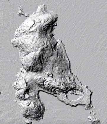
The effects of the glacier can be seen on Hurricane Island in a few ways. Looking at a LIDAR image of the island (Fig-
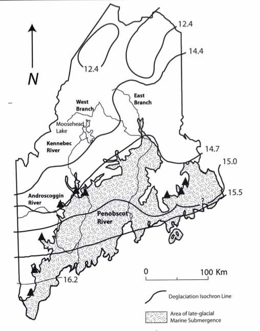
in thousands of years before present. Shaded area
land area submerged after deglaciation, with triangles indicating delta deposits at maximum extent of ocean intrusion. From The Changing Nature of the Maine Woods, by A. M. Barton (2012).1
ure 10) demonstrates one way that glacier’s reshape a landscape. A recurring pattern in Hurricane’s topography is one of extended, gentler slopes on the northwestern sides of hills and steeper southeastern slopes (accentuated, of course, by the quarry on the southeastern peninsula). This pattern mirrors the direction of the glacier's advance from northwest to southwest. The pattern occurs because the sloped side that first is covered by the glacier can gradually resist less and less of the crushing force of the ice as the slope increases, and at a critical point of tension, the rock breaks and boulders on the lee side of the glacier are dragged away by the glacier, leaving a steep face behind. This formation is common in deglaciated landscapes and is known as a “whaleback” or roche moutonnée – after the apparent resemblance of these landforms, at a distance, to a flock of sheep.
Soil deposits on Hurricane Island are also largely related to glacial events. This includes the deposition of till, a term for unsorted rocks and sediment embedded in the bottom layer of the glacier as it passed over landforms. Till is composed of
unsorted rocks and sediment of varying particle sizes. Rocks found in till deposits are often jagged and sharp, signifying the absence of extensive weathering by water. Such rocks can be found buried in the soils of the swale between Hurricane's two prominent hills. A small patch of clay beneath the sandy beach on the island's north end stands as testament to the island's period of submergence in deep, sediment-rich sea water immediately following the glacier's retreat. Clay only sinks out of suspension in deep, still water, so its presence on the north end can be directly attributed to that period of submergence. For a detailed overview of Hurricane's soils, see the Soils section.
Another notable legacy of the glaciers is the presence of socalled "erratics," or rocks that clearly do not originate from the area where they are found. Glacial erratics are common and easy to spot along the coastal areas of Hurricane. Crescentic gouges and drag marks (“glacial striations”) left by glaciers may exist on Hurricane as well.
Above all, the most visible effect of the Laurentide Ice Sheet on Hurricane Island is the very fact that the land here is an island in the first place. The Fox Islands, like all of Maine’s 3,100 islands, were once hilltops in a landscape that was subsequently submerged by a rising sea level. This is known as a “drowned” or submerged coastline. Additionally, since Maine’s bedrock layers tilt at an angle to the coast, weaker layers exposed to the water are preferentially eroded, result-
ing in a highly irregular coastline. Granite, being highly resistant to erosion, is exposed and weathered into islands as the rocks surrounding the plutons were worn away. Where the bedrock tilts directly towards the ocean (i.e., below 43˚ N on the New England coast) instead of at an angle to it, the coastline is less irregular.5,6
Maine’s coastal climate is strongly influenced by the large tidal oscillations (e.g., 9.78’ mean tidal range at Rockland, ME7) that mix cold water from the Labrador Current with warmer surface water. Prevailing winds from the south and southwest create frequent advection fogs, where warm air condenses into fog as it moves over a colder surface. This cool, moisture-rich climate increases total precipitation, reduces available sunlight, and reduces temperatures in warmer months – all effects with important consequences for forest composition (discussed further in the Climate section). In the winter, the ocean acts as a temperature buffer, keeping average winter low temperatures 2-4˚F warmer than those observed further inland.8
This strong marine effect is caused in part by strong tidal mixing. Tidal amplitude is determined by the shape of a water body and its resonance with lunar cycles. The large tidal oscillations observed in the Gulf of Maine (and much larger tides, up to 50’, in the Bay of Fundy) were established relatively recently, about 5,000 years ago, as the shape of the northeastern coast changed as a result of glacial erosion, the sinking and rebounding land mass, and sea level change in the thousands of years since the retreat of the ice
sheet.9,10
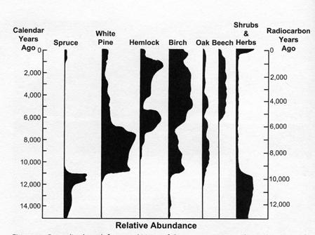
Interestingly, around this time, pollen records in Maine suggest that spruce was shifting northwards as the climate warmed, becoming mostly absent from the state by 11,000 years ago (see Figure 11). However, an analysis of bogs and hollows along the Maine coast, including sites in Penobscot Bay, indicate that spruce persisted as a dominant and codominant species in these areas despite being mostly absent elsewhere in the state.10 Spruce returned to Maine only about 1,000 years ago as the climate again cooled, and it is possible that these coastal sites acted as a refugium that facilitated the relatively rapid recolonization of the Maine landscape by spruce.
1. Barton, A. M. (2012). The Changing Nature of the Maine Woods. Durham, NH: University of New Hampshire Press.
2. Borns, H. J., Doner, L. A., Dorison, C. C., JAcobson Jr., G. L., Kaplan, M. R., Kreutz, K. J., … Weddle, T. K. (2004). The deglaciation of Maine, U.S.A. In J. Elhers & P. L. Gibbard (Eds.), Quaternary Glaciations - Extent and Chronology, Part II (pp. 89–109). Amsterdam: Elsevier B.V.
3. Kelley, J. T., Belknap, D. F., Kelley, A. R., & Claesson, S. H. (2013). A model for drowned terrestrial habitats with associated archeological remains in the northwestern Gulf of Maine, USA. Marine Geology, 338, 1–16. http://doi.org/10.1016/j.margeo.2012.10.016
4. Kelley, J. T., Belknap, D. F., & Claesson, S. (2010). Drowned coastal deposits with associated archaeological remains from a sea-level “slowstand”: Northwestern Gulf of Maine, USA. Geology, 38(8), 695–698. http://doi.org/10.1130/G31002.1
5. Kelley, J. T., Dickson, S. M., & Belknap, D. (1996). Maine’s History of Sea Level Changes. Maine Geological Survey. Retrieved from https://www1.maine.gov/dacf/mgs/explore/marine/facts/sealevel.pdf
6. Hogan, J. P., & Sinha, A. K. (1989). Compositional variation of plutonism in the coastal Maine magmatic province: mode of origin and tectonic setting. In Igneous and Metamorphic Geology (Vol. 4, pp. 1–33). Maine Geological Survey.
7. NOAA. (2003, April). Datums for 8415490, Rockland, ME. Retrieved from http://www.tidesandcurrents. noaa.gov/datums.html?id=8415490
8. Davis, R. B. (1966). Spruce-Fir Forests of the Coast of Maine. Ecological Monographs, 36(2), 80–94. http:// doi.org/10.2307/1942150
9. Gehrels, W. R., Belknap, D. F., Pearce, B. R., & Gong, B. (1995). Modeling the contribution of M2 tidal amplification to the Holocene rise of mean high water in the Gulf of Maine and the Bay of Fundy. Coastal Evolution in the Quarternary: IGCP Project 274, 124(1–4), 71–85. http://doi.org/10.1016/00253227(95)00033-U
10. Schauffler, M., & Jacobson, G. L. (2002). Persistence of coastal spruce refugia during the Holocene in northern New England, USA, detected by stand-scale pollen stratigraphies. Journal of Ecology, 90(2), 235–250. http://doi.org/10.1046/j.1365-2745.2001.00656.x
COLD WARMING COOL/DRY
Climate
+ 165-260 ft
+ 200 ft
Sea Level
0 (present)
Lower Dryas –12,900 to 11,600 yr BP
11,600 to 8,200 yr BP
- 200 ft
Years before present (BP)
Soil
15,500-15,000
Marine clays deposited
Till deposited
Vegetation
Tundra vegetation, migrating from northern refugia (Arctic and continental shelf)
- 130 ft - Lowstand
- 80-50 ft - "Slowstand"
Stable sea level and erosion of glacial sediments results in many mudflats and salt marshes along coastline, now submerged
Spruce (mostly P. glauca and P. mariana); alders, birches, willow by 12,000 yr BP
Oaks, maples, white pine make first appearance in Maine forests, largely replacing spruce-dominant forests. Spp. composition sustained by fires and dry climate; lasting until ~8,000 yr BP
8,200 to 5,400 yr BP
(generally for the northeast)
3,000 yr BP to industrial age
Tidal amplitude increases, and the Maine coast may have become cooler and wetter - inland is warmer and drier
- 15 ft ca. 7,000 yr BP - gradual increase to present (near present levels)
Hemlock, beech, and birch rapidly increase in abundance in Maine – less drought and fire tolerantperhaps a result of wetter conditions
Spruce decline in much of inland Maine, white pine becomes more abundant; however, coastal spruce populations remain
Sphagnum, spruce, alder become abundant on Maine coast, fern spores dramatically decrease in abundance
Regional: rapid expansion of spruce (1-2 generations) across state, from north and coastal refugia
The range of climates found in Maine is remarkable, encompassing temperate oak and pine forests in the southern coast, northern hardwood forests in the southern interior portion of the state, and sub-boreal spruce-fir forests from the mid-coast region north. The Penobscot Bay is located at a transition zone between these eco-regions, whose exact positions along the coast are maintained by climatic factors.
Part 1 of this section describes the climate of Penobscot Bay islands in the context of Maine, and summarizes the important factors that control climate in this region, such as the ‘marine effect’. The ecological classification of the Penobscot Bay region is discussed and, in particular, the role of this region as a tension zones between northern, boreal-affiliated species and southern temperate species. The connection between climate and disturbances such as storms and acid fog is explored.
Part 2 gives an overview of current scientific literature on climate change in Maine and those effects that may influence the ecology of the mid-coast region of Maine.
Key Points (part 1):
» The seasonal shifts in the position of the polar jet stream cause warm, south/southwesterly winds in the summer and cold, often stormy northeasterly winds in the winter in Maine
» The cold Labrador Current reduces temperatures, increases precipitation, and causes fog along the coast of Maine. This influence is known as the 'marine effect'
» Low elevation spruce-fir forests are favored by the moderate temperatures and fog, especially at the geographical edges of their ranges; according to one researcher, the proportion of abundance of spruce-fir forests is correlated with the intensity of the marine effect
» Fog in the mid-coast region can be very acidic (pH < 3.25), as air masses from the south and southwest travel over major urban areas (e.g. Boston, New York City) and collect pollution; the mid-coast region also receives high levels of ozone, mercury, nitrogen, and other types of deposition.
» The Penobscot Bay contains one of two major floristic tension/transition zones in Maine, where many plant species reach northern or southern range limits
» Hurricane Island's flora includes three species reaching their northern range limit and one species reaching its southern range limit
» The spruce-fir forest type reaches its southern, low-elevation limit of dominance (greater than 2/3 proportional cover) in Maine on Penobscot Bay islands
» As one of Maine's important transition zones for plant and bird species distributions, the Penobscot Bay may be a sensitive location for monitoring climate change in terrestrial ecosystems
» Many biotic and abiotic effects of climate change have already been observed in Maine
» Along the Maine coast, climate change is likely to raise temperatures, sea level, increase winter precipitation, decrease snow cover, extend the growing season, and intensify summer drought
» Paleoecological data suggests that the marine effect on the climate of the Maine coast may moderate changes in climate
» Citizen science monitoring efforts for terrestrial ecosystems along the Gulf of Maine focus primarily on invasives
» Acadia National Park is actively monitoring terrestrial ecosystems for the effects of climate change
New England is known for its seasonality, with warm, temperate weather in the summer and cold winters. The cause
of this seasonality is the changing position of a mass of cold, dry Arctic air that covers New England in the winter and is displaced by warm, tropical air in the summer. This dynamic boundary between the arctic and tropical air masses is called the polar front. The strong temperature gradient at this boundary feeds the fast-moving winds of the jet stream,
18

of Maine produces dense advection fogs along the Maine coast, and; lastly, intense winter storms with high winds from the northeast when the Polar Front moves south of Maine.
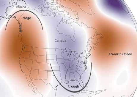
which flows from west to east across the continental United States along the boundary of the polar front. The jet stream is wave-like, dipping south from the Great Lakes to the southern Appalachians and bending north again along the east coast (Figure 12). As a result, warm continental air follows the jet stream as it bends north, reaching New England in the summer when the polar front is moved to the north.
In the winter, as the polar front moves south, the warm continental air is displaced by cold, arctic air with prevailing winds from the northeast. The intense winter storms that form in the North Atlantic are known as "nor’easters" after these strong winds.
These large-scale patterns of air circulation explain three very important aspects of the Maine coastal climate: first, prevailing winds in the summer months are warm, southerly and southwesterly winds; secondly, the temperautre gradient between warm air masses and the cold water of the Gulf
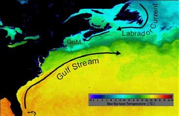
In addition to the pattern of air masses, the climate of Maine is strongly influenced by the Gulf of Maine. This cold, nutrient-rich water body is fed by the Labrador Current, a cold plume of water flowing south from the Arctic along the coast of North America (Figure 13). Mixing by large magnitude tides ensures that surface ocean temperatures remain cool.
In the Penobscot Bay, the amplitude of the strongest tides is around nine feet.3 Further north in the Bay of Fundy, tides exceed fifty feet.
Water bodies gain and lose kinetic energy (temperature) more slowly than air. As a result of this buffering effect of the ocean, the coast of Maine experiences cooler summers and warmer winters than other parts of the state. The significance of this effect is reflected in the earliest (and crudest) grouping of climate in Maine, established by the U.S. Weather Bureau in the 1950s and still in use today.4,5 This system recognizes three divisions in Maine: Northern (ME-1), Southern Interior (ME-2), and Coastal (ME-3) (Figure 14). Average
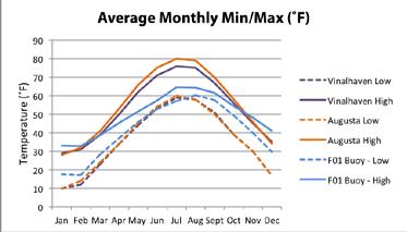
(U.S. Climate Data, www.usclimatedata.com) and data from the buoy are 2000-2015 averages (Buoy F01, http://www.neracoos.org/).
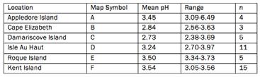
Fig. 16: pH of fog recorded on islands and headlands in the Gulf of Maine by Jagels et al. (1989). 7 Isle au Haut (D) is closest to Hurricane.
temperature and precipitation data from these divisions reflect the general trend of increasing temperature and precipitation in areas closer to the Gulf of Maine, a phenomenon known as the ‘marine effect’.
Figure 15 illustrates the marine effect on coastal climate, in a comparison of 30-year average air temperature data between two Maine weather stations, Vinalhaven and Augusta, and 15-year averages recorded by a buoy located in the Penobscot Bay between Hurricane Island and Owl’s Head.
Fog is frequent in the mid-coast region in the summer months, when warm air blowing from the south and southwest condenses over the cooler water of the Gulf.6 South of Casco Bay, prevailing winds often pass over land instead of the Gulf, and therefore fog is less frequent.
Fog reduces available light and increases moisture, conditions which benefit slow-growing, shade-tolerant tree species like spruce, hemlock and fir. Fog in summer months also favors small-seeded species like spruce, fir, and birch, whose seedlings do not have large reserves of energy and are therefore very susceptible to desiccation in the first few summers after germination.8 Fog concentrates on leaves, especially conifer needles, and concentrates into additional water that is used by the tree or understory plants.
Since the industrial age, however, air masses moving from the south and southwest have contained pollutants from coal-fired plants in the midwest as well as smog and ozone from urban areas such as Boston and New York. From the mid-coast region north The average acidity of fog sampled by Jagels et al. (1989) decreased (i.e., increased in pH) with latitude (Figure 16).7
Acidic fog has been linked to the decline of spruce in Maine’s
low-elevation spruce-fir forests, especially in the mid-coast region.7,9,10 Acid fog damages the protective wax cuticle on spruce needles, and can leach nutrients directly from the leaf.11 Increasing acidity of soils also depletes soils of nutrients, especially calcium, further impairing tree health.12 According to a recent (2012) assessment of the threats to flora of Acadia National Park (ANP), plants in this region are probably still exposed to acid fog at levels likely to affect growth and survival.13 Yet despite the potential impact of this on the coastal forests, fog chemistry data on the coast of Maine have not been published since the 1980s. Spruce mortality was observed in large patches in Hurricane’s forest, in most cases without any indication of pathogenic cause: this may be an important area for future research on Hurricane and in the mid-coast region, generally.
Ozone is another pollutant that is transported by fog to the coast of Maine. Ozone levels at Acadia National Park (ANP) are among the highest recorded anywhere on the east coast.14 Higher concentrations of mercury have also been observed in fog and in coastal sites compared to inland sites, posing a risk to human health, amphibian health, and marine life.14 Numerous studies of Hg, N, S, and other elemental deposition have been conducted at ANP (summarized in Vaux et al., 2008). ANP was identified as a regional “hot spot” for mercury deposition.
Therefore, while fog is an important climatic factor that helps maintain low-elevation spruce and fir along the coast of Maine, it may also be an agent of forest disturbance and mortality in these tree species.
More information on the condition of the spruce-fir community on Hurricane can be found in the Spruce-Fir Forests section.
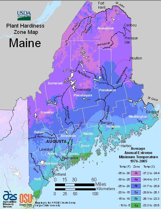
While the coast of Maine does generally receive more rainfall and experience less extreme temperatures than inland regions, the climate of the coast is not uniform. The USDA plant hardiness map of Maine (Figure 17) is determined by the annual extreme winter low temperatures, which vary along the coast. Extreme winter low temperatur is one important factor in long-term survival of woody perennial plants.15 Compared to the Weather Bureau climatic divisions (Figure 1), the plant hardiness zone map shows the difference, generally, between coastal and inland areas while also illustrating how southwestern-coastal and northeastern-coastal Maine differ in this biologically relevant way. Penobscot Bay islands, notably, represent a northern limit for the warmest hardiness zone type, 6a.
The specific climate of the Penobscot Bay is described by Janet McMahon (1990):
In most respects, the climate is intermediate between that of the East Coastal [east-northeast of Mount Desert Island] and mid-coast [Casco Bay] Regions. Although there is a distinct maritime influence, with high annual precipitation and frequent fog, higher summer temperatures result in a lower moisture surplus than in the East Coastal Region. Mean maximum temperature in July is 77° F, which is approximately 4° warmer than the East Coastal Region and slightly cooler than the mid-coast. Mean minimum temperature in January is 11° F, approximately 2° cooler than the East Coastal Region… average annual precipitation (49”) is higher than in any other region, average annual snowfall (63”) is less than that of the East and mid-coast Regions. This region also has a shorter growing season (140 days) than abutting coastal regions.
Like the Plant Hardiness Zone Map, McMahon identifies the transitional nature of the Penobscot Bay region in her description of the climate. This transition appears again in the plant composition of the region.
One of the most important ecological patterns in Maine is the high proportion of species reaching either northern or southern range limits in the state. Of forty-seven common tree species, nearly half (twenty-three) reach either a southern or northern range limit in Maine.16 In 1990, Janet McMahon published maps of the range limits of Maine’s native
woody plants, as well as a system of classifying Maine’s biophysical regions based on these range limits.17 Areas where plant species range limits converge are known as “transition zones”. The Penobscot Bay region is one of Maine’s two transition zones; the second roughly follows a 1,000-foot elevation contour along the foothills of the White Mountains in Western Maine. Nearly a third of all woody plant species (67 out of 240) mapped by McMahon reach their northern or southern range limit in the Penobscot Bay region. Figure 18 shows a modified version of McMahon’s original map.6
Hurricane Island’s flora includes a handful of species identi-
fied as at or near their range limit. Southern species reaching their northern limit include: common Juniper (Juniperus communis), nannyberry (Viburnum lentago), and blueflag iris (Iris prismatica). One northern species, black crowberry (Empetrum nigrum), is near its range limit in the Penobscot Bay, but in fact reaches its southern range limit further southwest, in the Casco Bay area.
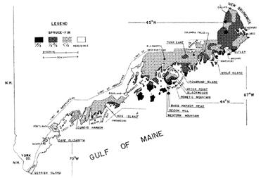
In 1966, Ronald Davis published the Spruce-Fir Forests of the Coast of Maine, a foundational paper that documented patterns of dominance of low-elevation spruce fir forests along Maine’s coast.18 In this work, Davis mapped variations in relative dominance of forest type along the coast of Maine (Figure 19). According to Davis, the islands of the Penobscot Bay represent a southern limit of dominance (>2/3 cover) of this forest type. McMahon acknowledged that same transition more generally, noting that spruce-fir forests occurred only on islands or exposed coastal headlands in the midcoast and south, and that the Penobscot Bay region was generally transitional between coastal spruce-fir and the southern coastal forests of pine and oak.
While the exact range limits of red spruce and balsam fir may not coincide with the Penobscot Bay transition zone, the forest assemblage where these two species are co-dominant does, in fact, approach its southernmost limit in the islands of the Penobscot Bay.
These larger-scale evaluations of species assemblages and landscape patterns illuminates the larger point that species often occur in predictable, repeating assemblages across the landscape as a function of climate, soils, geology, topography, and disturbance history. The concept of “natural communities” is one way to formalize these patterns, one that has been adopted by many states and widely implemented in conservation practice. In 2010, Susan Gawler and Andrew Cutko published the state of Maine’s official guide to natural communities, The Natural Landscapes of Maine, a version of which is also available online (http://www.maine.gov/ dacf/mnap/features/commsheets.htm).19 These resources were used to identify and delineate the natural communities of Hurricane Island during the summer of 2015. A description of the communities identified on Hurricane Island is included in the Natural Communities section.
As a major transitional zone for woody plants, birds, and other taxa in Maine, the mid-coast region (from Casco Bay to Mount Desert Island) may be an especially sensitive location
for detecting secondary, ecological climate-related changes in phenology, species distribution, pests, and pathogens. This review summarizes current scientific literature on observed and projected climate-related changes with a focus on the mid-coast region of Maine. Gaps in our current understanding of what climate change may bring to the Maine coast are also discussed.
In 2007, former Maine governor John Baldacci requested a synthesis report of the observed and projected impacts of climate change from the University of Maine’s Climate Change Institute. The Institute published an initial assessment report in 20096 and then in 2015 published an updated report.22 These two reports summarize general impacts already observed and those expected to occur in the state. Climate projections in these reports are frequently grouped into three climate divisions, using boundaries last revised in the 1950s by the Weather Bureau, which are largely based on USDA crop regions or drainage basins.4 While imperfect, these divisions nonetheless allow for some general observations of current trends as well as predictions about climate change along the Maine coast to be separated from predictions for inland regions.
The Third National Climate Assessment chapter on the Northeast confirms that changes in temperature and precipitation have already occurred in the last century, and projects that drought, heat waves, and intense precipitation events are all likely to become more frequent in the region.23 Observed trends as well as projections from these and other reports are summarized in Figures 20 and 21.
Maine, like the Northeast generally, has warmed in the last century, with steeper warming trends in winter months. Maine’s growing season has increased by at least two weeks, and is projected to increase by an additional two weeks by 2065.22 The increase in plant evapotranspiration coupled with declines in summer precipitation may intensify drought; Hayhoe et al. (2006) predict that short-term drought (1-3 months) may increase in Maine more than any other northeastern state. The increase in soil drying may increase fire risk in the region24; historically, the perhumid climate reduces the frequency of fire, an important distinction between Maine’s red spruce dominated sub-boreal forests and boreal forests farther north.25
Changes along Maine’s coast differ from those predicted for inland areas. Warming is predicted to be less rapid along the coast compared to other parts of the state, due to the buffering effect of the Gulf of Maine. Similarly, annual precipitation is predicted to increase less along the coast (1-5%)
compared to northwestern Maine (5-7%). However, the type and distribution of precipitation events may change most dramatically along the coast. While snow is expected to become less frequent across the state, the greatest predicted declines (up to 40%) occur in the coastal climatic zone.22 Extreme precipitation events have already increased more along the coast than they have inland.22 Since most major storm events in Maine originate offshore26, the increase in extreme weather events will disproportionately affect coastal areas. Sea level rise and flooding are projected for coastal areas, although these changes will not affect rocky headlands and islands as much as saltmarshes, coastal estuaries, beaches and sandy bluffs.
A summary of projected effects of climate change in Maine and the Northeast from several climate reports is given in table.2 Where possible, specific projections for the Maine coast are included in the table, as well as projections for the Northeast U.S. for purposes of comparison.
Biological responses to climate change are already occurring. Temperature-sensitive processes such as spring leafout and bloom in plants, bird migration patterns, and increases in some pathogens have already been observed in the northeast. Wolfe et al. (2005) analyzed spring indices in records of lilac clones, apple, and grape cultivars in the northeast U.S. and calculated a statistically significant advance in first flower date of about –2.10 days per decade.27 Hayhoe et al. (2006) project a continued advance in spring indices yeilding an advance of 1-2 weeks by 2100. 32 Numerous documented phenological changes in fauna of the U.S. northeast are summarized by Rodenhouse et al. (2009), and include earlier initiation of migratory bird arrival and breeding and amphibian mating calls.29
Range shifts and population changes are also observed, though historical data are limited in most taxa other than birds.28 Fifteen of 25 bird species that remain in the northeast year-round are increasing in abundance, and both resident birds and neotropical migrants are expected to increase their range as a result of climate change.28–30
Projections of range expansion for bird species are tied to projections of forest cover changes 28. Notably, the sprucefir forest type is projected to largely disappear from Maine 30 , as are bird species that depend on this habitat type such as Bicknell’s thrush in high-elevation spruce-fir forests 31. However, the response of spruce-fir forests to climate change, at both high and low elevations, is confounded by other factors unrelated to climate change (i.e., reduction in acid deposition and ozone) and by local variations in climate, especially along the Maine coast where the distribution of the sprucefir forest type is correlated with the moderating effect of the marine climate.18
The response of the low-elevation spruce-fir forests on the Maine coast to climate change is a major unresolved question. Evidence from sediment cores from Maine islands suggests that the Maine coast was an important refugium for red spruce during a warm, dry period roughly 5,000 years ago when spruce was mostly absent from the state34, leading Jacobson et al. (2009) to conclude in the Initial Assessment of climate change in Maine that red spruce will “remain on a narrow strip of east-coastal Maine, in greater contrast to inland areas.” Other studies and reviews conclude that spruce-fir forests will virtually disappear from the Maine coast.30,36 Contrasting reports of range shifts in red spruce in the last decade (36,37) deepens the uncertainty about how this important forest type will respond to climate change.
Maine’s coast presents a challenge to climate models because of the large gradients in climate experienced over a fine scale and the importance of interactions between marine and terrestrial factors. Nonetheless, the location of a major transition zone between boreal and temperate ecoregions, the Maine coast may be a sensitive location for detecting species shifts projected by numerous summary reports. While much of the rocky coast of Maine will be relatively unaffected by rising seas, a change in disturbance patterns due to increased storm events and fires could facilitate more rapid changes in species patterns.
Current climate change monitoring efforts for terrestrial ecosystems on the Maine coast appear to be mostly centralized around Acadia National Park, which participates in the Northeast Temperate Network (NETN) ‘Vital Signs’ monitoring program among national parks of the northeast (http:// science.nature.nps.gov/im/units/netn/). The ‘vital signs’ monitored include climate indicators, invasive plants, forest pathogens, phenology, water quality, and many others. An extensive record of species from many taxa spanning decades is one major asset found in the Park and few other places on the Maine coast. Additionally, two reports on threats to the natural resources of Acadia National Park have been published 13,14, and while neither report addresses climate change specifically, each describes stressors and recent changes observed in the region.
The Gulf of Maine Research Institute (GMRI), based in Portland, ME, has created a platform to host citizen science projects in the region, focused on invasive species (http://vitalsigns.gmri.org/). The GMRI also calls this monitoring project “Vital Signs”, although it is not connected to the NETN program.
1. NOAA. (2014). U.S. temperature extremes and the polar jet stream. Retrieved from https://www.climate. gov/news-features/event-tracker/us-temperature-extremes-and-polar-jet-stream
2. Gulf of Maine Census. (2016). Circulation. Retrieved from http://www.gulfofmaine-census.org/about-thegulf/oceanography/circulation/
3. NOAA. (2003, April). Datums for 8415490, Rockland, ME. Retrieved from http://www.tidesandcurrents. noaa.gov/datums.html?id=8415490
4. Guttman, N. B., & Quayle, R. G. (1996). A Historical Perspective of U.S. Climate Divisions. Bulletin of the American Meteorological Society, 77(2), 293–303. http://doi.org/10.1175/15200477(1996)077<0293:AHPOUC>2.0.CO;2
5. U.S. Climate Divisions. (2015). NOAA. Retrieved from http://www.ncdc.noaa.gov/monitoring-references/ maps/us-climate-divisions.php
6. Jacobson, G. L., Fernandez, I. J., Mayewski, P. A., & Schmitt, C. V. (Eds.). (2009). Maine’s Climate Future: An Initial Assessment. University of Maine. Retrieved from http://www.climatechange.umaine.edu/ mainesclimatefuture/
7. Jagels, R., Carlisle, J., Cunningham, S., Serreze, S., & Tsai, P. (1989). Impact of Acid Fog and Ozone on Coastal Red Spruce. Water, Air, and Soil Pollution, 48(1), 193–208.
8. Blum, B. M. (1990). Red Spruce. In Silvics of North America, Volume 1: Conifers. Washington: USDA Forest Service. Retrieved from http://www.na.fs.fed.us/pubs/silvics_manual/Volume_1/picea/rubens. htm
9. Jiang, M., & Jagels, R. (1999). Detection and quantification of changes in membrane-associated calcium in red spruce saplings exposed to acid fog. Tree Physiology, 19(14), 909–916. http://doi. org/10.1093/treephys/19.14.909
10. Kimball, K. D., Jagels, R., Gordon, G. A., Weathers, K. C., & Carlisle, J. (1988). Differences between new england coastal fog and mountain cloud water chemistry. Water, Air, and Soil Pollution, 39(3), 383–393. http://doi.org/10.1007/BF00279483
11. Jagels, R., Jiang, M., Marden, S., & Carlisle, J. (2002). Red spruce canopy response to acid fog exposure. 2nd International Conference on Fog and Fog Collection, 64(1–4), 169–178. http://doi.org/10.1016/ S0169-8095(02)00089-3
12. Shortle, W. C., & Smith, K. T. (1988). Aluminum-Induced Calcium Deficiency Syndrome in Declining Red Spruce. Science, 240(4855), 1017–1018. http://doi.org/10.1126/science.240.4855.1017
13. Harris, T. B., Rajakaruna, N., Nelson, S. J., & Vaux, P. D. (2012). Stressors and threats to the flora of Acadia National Park, Maine: Current knowledge, information gaps, and future directions. The Journal of the Torrey Botanical Society, 139(3), 323–344.
14. Vaux, P. D., Nelson, S. J., Rajakaruna, N., Mittelhauser, G., Bell, K., Kopp, B., … Longsworth, G. (2008). Assessment of natural resource conditions in and adjacent to Acadia National Park, Maine (Natural Resource Report No. NPS/NRPC/WRD/NRR–2008/069). Fort Collins, CO: U.S. Department of the Interior, National Park Service.
15. Daly, C., Widrlechner, M. P., Halbleib, M. D., Smith, J. I., & Gibson, W. P. (2012). Development of a New USDA Plant Hardiness Zone Map for the United States. Journal of Applied Meteorology and Climatology, 51(2), 242–264.
16. Barton, A. M. (2012). The Changing Nature of the Maine Woods. Durham, NH: University of New Hampshire Press.
17. McMahon, J. S. (1990). The biophysical regions of Maine: patterns in the landscape and vegetation. University of Maine, Orno.
18. Davis, R. B. (1966). Spruce-Fir Forests of the Coast of Maine. Ecological Monographs, 36(2), 80–94. http:// doi.org/10.2307/1942150
19. Gawler, S., & Cutko, A. (2010). Natural Landscapes of Maine: A Guide to Natural Communities and Ecosystems. Augusta: Maine Natural Areas Program.
20. Boone, R. B., & Krohn, W. B. (2000). Relationship between Avian Range Limits and Plant Transition Zones in Maine. Journal of Biogeography, 27(2), 471–482. http://doi.org/10.2307/2656274
21. Krohn, W. B., Boone, R. B., & Painton, S. L. (1999). Quantitative Delineation and Characterization of Hierarchical Biophysical Regions of Maine. Northeastern Naturalist, 6(2), 139–164. http://doi. org/10.2307/3858346
22. Fernandez, I. J., Schmitt, C. V., Birkel, S. ., Stanicioff, E., Pershing, A. J., Kelley, J. T., … Mayewski, P. A. (2015). Maine’s Climate Future: 2015 Update. Orno, ME: University of Maine.
23. Horton, R., Yohe, G., Easterling, W., Kates, R., Ruth, M., Sussman, E., … Lipschultz, F. (2014). Ch. 16: Northeast (Climate Change Impacts in the United States: Third National Climate Assessment). U.S. Global Change Research Program.
24. Whitman, E., Sherren, K., & Rapaport, E. (2014). Increasing daily wildfire risk in the Acadian Forest Region of Nova Scotia, Canada, under future climate change. Regional Environmental Change, 15(7), 1447–1459. http://doi.org/10.1007/s10113-014-0698-5
25. Lindbladh, M., Jacobson Jr., G. L., & Schauffler, M. (2003). The postglacial history of three Picea species in New England, USA. Quaternary Research, 59(1), 61–69. http://doi.org/10.1016/S00335894(02)00023-6
26. Huntington, T. G., Richardson, A. D., McGuire, K. J., & Hayhoe, K. (2009). Climate and hydrological changes in the northeastern United States: recent trends and implications for forested and aquatic ecosystems. Canadian Journal of Forest Research, 39(2), 199.
27. Wolfe, D. W., Schwartz, M. D., Lakso, A. N., Otsuki, Y., Pool, R. M., & Shaulis, N. J. (2005). Climate change and shifts in spring phenology of three horticultural woody perennials in northeastern USA. International Journal of Biometeorology, 49(5), 303–309. http://doi.org/10.1007/s00484-004-0248-9
28. Rodenhouse, N. L., Christenson, L. M., Parry, D., & Green, L. E. (2009). Climate change effects on native fauna of northeastern forests. Canadian Journal of Forest Research, 39(2), 249–263. http://doi. org/10.1139/X08-160
29. Rodenhouse, N. L., Matthews, S. N., McFarland, K. P., Lambert, J. D., Iverson, L. R., Prasad, A., … Holmes, R. T. (2007). Potential effects of climate change on birds of the Northeast. Mitigation and Adaptation Strategies for Global Change, 13(5), 517–540. http://doi.org/10.1007/s11027-007-9126-1
30. Rustad, L., Campbell, J., Dukes, J. S., Huntington, T., Fallon Lambert, K., Mohan, J., & Rodenhouse, N. (2012). Changing Climate, Changing Forests: The Impacts of Climate Change on Forests of the Northeastern United States and Eastern Canada (General Technical Report No. NRS-99). Newtown Square, PA: U.S. Forest Service.
31. Matthews, S. N., O’Connor, R. J., Iverson, L. R., & Prasad, A. M. (2004). Atlas of Climate Change Effects in 150 Bird Species of the Eastern United States (General Technical Report No. NE-318). Newtown Square, PA: U.S. Department of Agriculture, Forest Service.
32. Hayhoe, K., Wake, C., Anderson, B., Liang, X.-Z., Maurer, E., Zhu, J., … Wuebbles, D. (2007). Regional climate change projections for the Northeast USA. Mitigation and Adaptation Strategies for Global Change, 13(5), 425–436. http://doi.org/10.1007/s11027-007-9133-2
33. Rawlins, M. A., Bradley, R. S., & Diaz, H. F. (2012). Assessment of regional climate model simulation estimates over the northeast United States. Journal of Geophysical Research. Atmospheres, 117(23). http://doi.org/10.1029/2012JD018137
34. Schauffler, M., & Jacobson, G. L. (2002). Persistence of coastal spruce refugia during the Holocene in northern New England, USA, detected by stand-scale pollen stratigraphies. Journal of Ecology, 90(2), 235–250. http://doi.org/10.1046/j.1365-2745.2001.00656.x
35. Iverson, L., Prasad, A., & Matthews, S. (2007). Modeling potential climate change impacts on the trees of the northeastern United States. Mitigation and Adaptation Strategies for Global Change, 13(5), 487–516. http://doi.org/10.1007/s11027-007-9129-y
36. Beckage, B., Osborne, B., Gavin, D. G., Pucko, C., Siccama, T., & Perkins, T. (2008). A rapid upward shift of a forest ecotone during 40 years of warming in the Green Mountains of Vermont. Proceedings of the National Academy of Sciences, 105(11), 4197–4202. http://doi.org/10.1073/pnas.0708921105
37. Foster, J. R., & D’Amato, A. W. (2015). Montane forest ecotones moved downslope in northeastern USA in spite of warming between 1984 and 2011. Global Change Biology, 21(12), 4497–4507. http://doi. org/10.1111/gcb.13046
Six groups of people known to have occupied and used Hurricane are described here: Native Americans, early European colonizers and homesteaders, the Hurricane Island Granite Company, the current owners (Gaston family), Hurricane Island Outward Bound School (HIOBS), and the Hurricane Island Center for Science and Leadership (HICSL), Both HIOBS and HICSL leased a majority portion of the island from the current owners, who maintain a summer residence on the southwest peninsula.
The activities of these people have left many traces on Hurricane. Some are as apparent as the face of the granite quarry, and the drill holes and discarded tools found at almost every turn. Others, like the earthworms in the soil or the low stone wall on the north end of the Island, are subtler. This section first presents an overview of the people that have inhabited Hurricane and gives historical context for their presence (Part 1). Then, specific ecological impacts that can be attributed to human activity, in particular, changes in species composition, topography, forest structure, and disturbance are discussed (Part 2).
Hurricane Island is an important piece of the Penobscot Bay history. Suggestions for maintaining the integrity of the Island's historical and natural features are described in the Protecting Hurricane's Resources section at the end of this report.
» Native American groups likely used the sandy beach on Hurricane Island's northeastern shore
» Regional historical context, ownership records, forest age, and a few artifacts on the Island's north end suggest that the Island was cleared for timber/fuel or pasture several times since ca. 1765
» Deforestation, extinctions, and introductions of species were the major ecological impacts of the European colonization of islands in the Gulf of Maine
» Lasting impacts of the Hurricane Island Granite Company era (1870-1914) include alterations of the topography of Hurricane, structure of the coastline, freshwater hydrology, plant species composition, and vegetation patterns on Hurricane Island.
» The use of the island by the Hurricane Island Outward Bound School (HIOBS) and the Hurricane Island Center for Science and Leadership (HICSL) generally reinforce landscape patterns established during the quarry era, though new trails cause erosion and introduce species in the upland forests
» Forest regeneration is affected today by landscape patterns established in the quarry era
» Non-native species are common on Hurricane: 42 of 140 vascular plant species (30%) identified on Hurricane are non-native; 6 species of earthworms; introduced raccoons are a nuisance on the island
Though we do not know the exact identity of the earliest occupants of Hurricane Island, evidence of their presence here is gleaned from a few worked stone tools found on the sandy beach on the Island’s north end. This beach, protected from large ocean swells from the south, would have provided an ideal landing site for canoes. A more detailed study of these artifacts might yield indications of exactly which time period and cultural group these artifacts are connected to.
In a 1996 survey of archaeological sites in East Penobscot Bay, David Sanger documented 276 individual sites on islands, most of which were found on larger islands such as Isle au Haut. However, regarding smaller islands, Sanger notes that “virtually every small island supported at least one site provided a suitable canoe-landing cove existed.”1
The Turner Farm site on North Haven Island, just a few miles from Hurricane, is one of the most informative and well-characterized archaeological sites in the Penobscot Bay. The site contains a complex stratigraphy of shell middens, artifacts, charcoal, faunal remains, human burial sites, and dwellings that span an astounding 5,000 years of human history. The Turner Farm site has been studied and described extensively by Bruce Bourque in several publications2,3 and more recently by Speiss and Lewis.4 Judd, Churchill, and Eastman’s (eds.) Maine: The Pine Tree State, from Prehistory to the Present (1995) provides an overview of these different cultural groups and their place in Maine’s human history.5
Records of titles and taxes show that the island changed hands many times between 1772, when it was first named as Hurricane Island, and 1870, when the island was pur-
chased by General Tilson and the era of granite quarrying began.
Hurricane Island was most likely cleared for lumber/fuel and used for pasturage between 1765-1870. The best evidence supporting this is a settlement on the north end of the island where a cellar hole, a chimney, a well, and a low stone wall of rounded stones still remain. The town plan of Hurricane Island, established 1872 (Figure 24), shows no settlement here, and the rounded stones suggest pre-quarry settlement. There is a soft, light-colored metal piece of flashing on the chimney that is likely lead. It is not known who this settler was or what their occupation was. Historical context of human settlement in the region sheds some light on likely possibilities. One possibility was that the island, having been cleared for timber for Vinalhaven’s sawmill or fuel for the lime kilns in Rockland, was used for pasturage or as a seasonal residence for fisherman, like many islands in the region. Earthworms are found in this area, which may have arrived with this settler, or they may have arrived through the activity of Outward Bound.
A more detailed investigation of this site may yield some interesting information about the identity and occupation of this settler.
The following timeline of Hurricane Island’s ownership and population comes from McClane’s Islands of Mid-Maine Coast (1982).6
» 1772: The island is first named as “Hurricane Island” in a 1772 deed, when William Heard sold the island and 8 others west of Hurricane Sound to James Heard
» 1780s: Hurricane Island likely conveyed to Isaac Crocket, no title found
» 1785: Appears as “Island R” on first official map of Vinalhaven
» 1807: Sold to George Gardiner, a mariner from the Kennebec region, by Ephraim Crocket for $60
» 1831: Sold to Oliver Brown of Vinalhaven
» 1848: Sold to George W. Vinal
» 1852: Sold to Joseph Ginn of Greens Island
» (other transactions recorded, but, according to McClane, “none that enlarge our perspective of Hurricane Island or suggest settlement.”)
» 1859: Map of Waldo County shows no structures on the island
» 1870: Sold to General Davis Tillson
» 1872: Hurricane Island Granite Company appears in tax records in Vinalhaven
» 1876: 172 taxpayers listed on Hurricane
» 1878: Island incorporated as a separate township, with its own post office, town hall, firehouse, and
jail. McClane: “population of six hundred shown for 1878 may be accurate…”
» 1880: Census shows 220 permanent residents
» 1888: Cannery on Hurricane employs fifty female workers from Vinalhaven
» 1900: 264 permanent residents recorded in the Census
» 1910: 256 permanent residents
» 1920: 11 permanent residents (Philbrook family)
» 1924: Hurricane Island sold to Gaston Family
» 1964: Hurricane Island leased to Outward Bound
Hurricane Island was purchased in 1870 by General Davis Tilson, who established a granite company and lobster cannery on the Island. Although Tilson died in 1895, the granite company continued operating until 1914. The granite company established a town on the island, which was incorporated in 1878. Although census records do not exceed 264 permanent residents (1910), day workers from Vinalhaven and other temporary workers may have comprised a substantial portion of the island workforce, and thus the true populaton may have been higher.
For a more complete historical account of the Hurricane Island Granite Company, see Elanor Richardson’s book Hurricane Island: The Town that Disappeared (1997). 13
By 1901, the peak of the short-lived granite boom in the state, there were 152 active quarries - most of them along the coast.14 Figure 27 shows the location of the granite quarries along the coast. Hurricane Island was one of the five most productive quarries in Maine, along with Vinalhaven, Clark Island, Crotch Island, and Dix Island.15
The earliest quarry on Hurricane Island was located along the northeastern side of the island, next to a deep cove that is protected from both prevailing summer southwesterly winds and storm winds from the northeast. Figure 28 shows a historic photograph of this first quarry.
The northeast quarry was eventually abandoned in favor of granite from the southeastern peninsula. The sheets of granite there were thicker, allowing longer sections to be extracted. The uniformity and angle of these layers was especially important for extracting large pieces of granite to turn in to columns. The Vinalhaven quarry, for instance, produced some of the largest granite pieces on record from this time, including four columns bound for the Cathedral of St. John the Divine in New York, NY. Before polishing, each column was 64 feet long and 8 feet in diameter and weighed about 300 tons.7
To cut granite, a team of quarry workers perforated the top of the stone with small holes. Initially, this task was accomplished by a team of three workers: one to hold the drill bit
while two others took turns hammering the bit with heavy sledges. Later, steam-powered drills replaced this work. Once the line of holes was made, iron shanks were put in each hole with a thick spike in between the shanks. Sledging the spikes in unison would drive the shanks outward, splitting the rock along the grain (explosive powder was also used in some quarries).7 Blocks were hauled off the quarry face by derricks, and moved by animal-drawn carts to the polishing shed. In this way, half of the dome of granite that once covered the southeast peninsula was removed.
Many smaller quarries, called "motions", can be found scattered throughout Hurricane. These smaller quarries supplied individual laborers with stone for cobbles, which individual stonecutters made to supplement their income from the granite company. In one twelve-day period, for instance, 320,465 paving stones were hauled from Hurricane's wharves.7 Several of these motions, like the larger granite quarry, are now filled in with freshwater.
The cannery was located near the wharf on the eastern portion of the island.
The current owners of the island maintain a private residence on the island, which has been restricted to visitors and HIOBS/HICSL staff. Permission was granted for a quick inventory of the peninsula for this report.
The exposed headlands here have the most well developed mats of creeping juniper anywhere on the island. This species recovers slowly from frequent trampling, according to a 1985 study of plant recovery on Hurricane Island after experimental trampling. The study concluded that certain coastal species such as bayberry, horizontal juniper, and black crowberry recovered poorly (20-60 percent recovery) one year after 100 tramples (a trample is defined as “a oneway pass by a single person”).18 Red spruce, by contrast, was “largely unaffected” by tramples. Maintaining this area as a restricted-access area will preserve this habitat, which is
described in detail in the Natural Communities section.
The Hurricane Island Outward Bound School (HIOBS) operated on Hurricane Island from 1964-2006. A history of this time is forthcoming by Susan St. John. Through constant and active use, the HIOBS era reinforced landscape patterns established during the quarry era: tent platforms were made where the quarry town once stood, many over former well sites. Most roads described in the town plan were used as trails (Figures 24, 25).
The Hurricane Island Center for Science and Leadership (HICSL) uses the same areas and much of the infrastructure (much of it renovated) as HIOBS – and therefore continues to reinforce landscape patterns established during the quarry era.
Recommendations to HICSL for management of Hurricane's natural and cultural resources are provided in the Protecting Hurricane's Resources section at the end of this report.
Regional
of European settlement of the Fox Islands (1700 - ca. 1850)
On the islands of the Maine coast, there were three major region-wide ecological impacts of European settlement: deforestation of islands for timber, fuel for lime kilns, and pas-
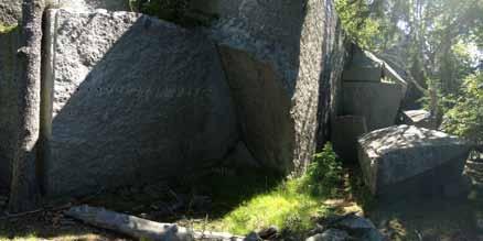
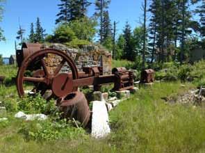
Historical map of Hurricane Island from 1910. Northern half of the study area intersects the portion of the island that was forested at that point in time.
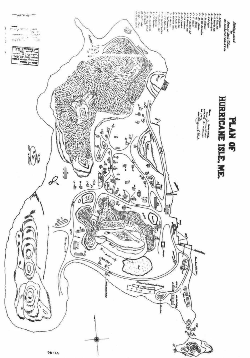
HIF
HIF
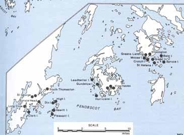
turage; overharvesting of fish, mammals, and waterfowl; and introductions of new species, especially plants and mammals.
As early as 1765, a sawmill operated on Vinalhaven. By the mid-1800s, the lime kilns in nearby Rockland used 30 cords of wood per week, mostly spruce. Nearby islands were cleared of spruce, to such an extent that ships sailed to Eastport and the Maritime provinces for fuel.7
According to historical witness tree records and pollen core samples, the islands of the Penobscot bay contained beech, white pine, oak, and hemlock and other species but were still, as they are today, dominated by spruce-fir forests.8 Further south, oak and pine (primarily white pine and pitch pine) are major components of the coastal forests.9
It is likely that clearing the islands several times in the past few centuries tipped the species balance here even more in favor of spruce-fir and small-seeded, disturbance colonizing hardwoods such as birch and aspen. If hardwoods such as oak and beech were ever a component of Hurricane’s forests, they are today absent. A lone red maple and mountain maple are found on the island, as well as three large ornamental hardwoods planted by the quarry settlers, but they are the exception. On Hurricane, dominance of spruce-fir with interspersed patches of early-successional hardwoods is the simplest assessment of the forest condition.
Absent any archaeological record, there is no way to identify exactly what species existed on Hurricane before settlement. However, it is likely that Hurricane once supported an extinct species of mink, the sea mink (Neovison macrodon), that was endemic to the region until it was extirpated sometime in the late 1800s. Some of the strongest evidence supporting classification of the sea mink as a separate species
comes from a 2007 study of 111 specimens of teeth and bones found at the Turner Farm site. 10
In addition to the sea mink, three bird species found in this region were hunted to extinction during this time: the Passenger Pigeon (Ectopistes migratorius), Great Auk (Pinguinus impennis), and the Labrador Duck (Camptorhynchus labradorius). Down and egg collection dramatically reduced populations of at least 15 seabird species, some of which have recovered and at least 6 that remain endangered. 11
On Hurricane Island, introduced populations of raccoons (Procyon lotor) are a nuisance on the island, having no natural predators and an abundant food supply.
Earthworms were introduced to Hurricane’s soils, though when and by whom remains uncertain. Any native earthworms that populated northeastern North America were erased from the landscape by the movement of glaciers. In the past few centuries, earthworms have arrived from Europe in soils used for plants or even adhering to ballast.12 Earthworm species identified can be found in Appendix B
A substantial proportion of the flora of Hurricane Island is composed of introduced species. Of 140 vascular plant species identified, 42 (30%) are introduced species. The proportion of introduced species is highest in herbaceous plants: 35 of 95 species identified (54%) are non-native.
It is difficult to say exactly when herbaceous species arrived. Timothy hay (Phleum pretense) may have been cultivated for pasture, but it is also widespread and naturalized in the northeastern U.S. and may have simply traveled to the island by birds or humans unintentionally. Other species may have arrived with early settlement or later with the granite quarry town, Outward Bound, or more recently with the present occupants. From descriptions of the quarry town and historical photos, some of the decorative woody perennials such as lilac (Syringa spp.) and apples (Malus pumila) and trees such as American elm (Ulmus americana) and horsechestnut (Aesculus hippocastanum) can be associated with the quarry era.13
A list of vascular plant species identified in June-August 2015 is included in Appendix A
Increase in number of freshwater ponds
» Changes to the physical landscape related to the quarry era, created new hydrologic features on the island, including:
» Two larger quarry ponds
» "Ice pond" between two hills
» Reservoir on eastern slope below a spring to supply steam for flywheel – mostly dry now
» Several smaller “motions”, now filled in with stagnant water
» Numerous wells
These freshwater features create habitat for aquatic/obligate wetland species unlikely to exist before quarry, such as cattails (Typha angustifolia), pondweed (Potamogeton epihydrus), green frogs (Rana clamitans), and pumpkinseed sunfish (Lepomis gibbosus). They also extend habitat for obligate wetland species that may have existed in smaller patches on the island before the quarry era, such as: large cranberry (Vaccinium macrocarpon), thread rush (Juncus filiformis) and toad rush (Juncus bufonius). Raccoons and mink both benefit from (but do not depend on) the addition of freshwater and the subsequent increase in prey species such as green frogs. Finally, humans benefit greatly from these freshwater pools: the main quarry pond supplies drinking, bathing, and wash water for the island’s owners, HICSL and, previously, Outward Bound (which also used the main quarry pond for swimming). Without this pooling of freshwater, the island would not likely be able to support as many visitors. The quarry town residents used wells dug in the island’s small pockets of deeper soil and till; ice was harvested from the pond in between the two hilltops.
These ponds are described in greater detail in the Natural
Sunset Hill pond
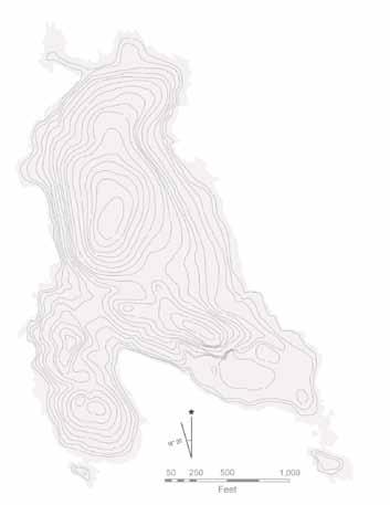
Reservoir
Communities section.
Ditching and channeling along east-facing slope to direct water to reservoir. Two systems of channels and catchments were created on Hurricane Island, the first to provide water for the steam-powered flywheel, and the second to drain water from the quarry. To accomplish the first task, ditches and channels were made in the east-facing slope, collecting in a small catchment, fortified with stone walls, that no longer holds water (standing water is present only after rains). The mud of this pond often is marked with animal tracks, mostly raccoon, deer and occasionally mink. A second channel, now dry, was created to drain the quarry on the southeastern peninsula. The impact of these drainages is less drastic than that of the ponds: it may be only to benefit mammal and amphibian species with good prey habitat, fresh water, and shelter (the reservoir, for instance, is difficult to get to and deer beds are common here).
Debris piles of rough-cut or discarded stone. Large quantities of stone were discarded in the quarrying and polishing process, and some intentionally moved to create two wharves along the shore: one near the northeastern quarry (Valley Cove) and another just below the east-facing slope where the town once was. The wharf on the eastern shore, with its attached dock, is still used today by the current owners as well as HICSL. The Valley Cove pier and building will be, once completed, a laboratory space for HICSL. Discarded stone lines the shore near both quarries and both wharves.
Inland, there are two large piles of discarded stone near main quarry face, which are mostly barren of plant species, except those near the base of the piles and in moister areas. It may take many decades before enough soil accumulates to revegetate these rock piles. Raccoons, however, take advantage of the gaps in the rocks for denning sites – detected by tracks and latrines near the talus piles.
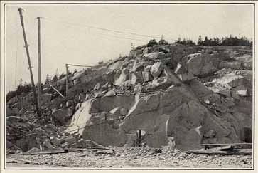
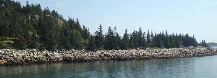
Clearings on the eastern and western slopes. The town plan of Hurricane Island, created in 1910 (Figure 24) shows areas that were cleared and areas left as forest. Images from the quarry town, from Elanor Richardson's Hurricane Island: The Town that Disappeared (1997), show pockets of forest behind the town. No images of the northern parts of the island are available. A small sample of tree cores and counted rings of cut stumps indicates that some areas may indeed have been left untouched, but a more detailed dendrochronological investigation would lend a much finer resolution to disturbance histories of the forested areas. Two cut stumps on the northern portion of the island were aged at 150 and 120 years, and three tree cores of red spruce along the northern hillside made in the summer of 2014 by Chloe Tremper were aged at 109, 158, and 101 years.17 While not conclusive evidence that these areas were as completely forested as depicted on the town map, the fact that all trees aged were at least 100 years old suggests they were established before the quarry town was abandoned in 1914.
Meadow/Shrub Areas. The areas shown as cleared on the town map (Figure 24) correspond with areas on the island dominated by grasses and shrubs, specifically: a large section of the island's eastern hillside where the quarry town was situated remains open, with patches of bedrock exposed and other areas dominated by grasses and pockets of shrubs. Of these grasses, herbs, and shrubs, several species most likely planted during the quarry era persist today.
Since the abandonment of the Hurricane Island Granite Company town, Hurricane's human population has declined and become seasonal: both HIOBS and HICSL were/are active on the island only from (approximately) March through October.
Early-successional areas are described in greater detail in the Natural Communities section.
Though a number of tent platforms built by HIOBS are still in use by the Hurricane Island Center for Science and Leadership (HICSL), there are several, especially on the higher portions of the eastern slope, that are no longer used. These structures are carpeted with moss and lichen, and in one instance are the site of abundant regeneration by red spruce. Grass species, which are mostly confined to lower portions of the island, are found by the tent platforms: suggesting that people traveling to and from tent platforms acted as vectors for the spread of these species. Grasses and other plants (especially raspberry and hay-scented fern) can become established in canopy gaps and out-compete red spruce regeneration, especially as nearby red spruce die off and available light increases around tent platforms. Interestingly, on at least one tent platform, red spruce grew on the moss-covered platform as a substrate. While rotting wood could favor spruce regeneration over grass and raspberry, due of the hazards posed by the nails left behind and the structural instability, it is recommended that these platforms be removed (see Protecting Hurricane's Resources)
1. Sanger, D. (1996). Testing the Models: Hunter-Gatherer Use of Space in the Gulf of Maine, USA. World Archaeology, 27(3), 512–526.
2. Bourque, B. J. (1975). Comments on the Late Archaic Populations of Central Maine: The View from the Turner Farm. Arctic Anthropology, 12(2), 35–45.
3. Bourque, B. J. (1995). Diversity and Complexity in Prehistoric Maritime Societies: A Gulf of Maine Perspective. New York, NY: Plenum Press.
4. Speiss, A., & Lewis, R. A. (2001). The Turner Farm Fauna: 5000 years of hunting and fishing in Penobscot Bay, Maine. Occasional Publications in Maine Archaeology, 11, 1–177.
5. Judd, R. W., Churchill, E. A., & Eastman, J. W. (Eds.). (1995). Maine: The Pine Tree State from Prehistory to the Present. University of Maine Press.
6. McClane, Charles B. (1982). Islands of the Mid-Mane coast: Penobscot and Blue Hill Bays. Woolwich: The Kennebec River Press.
7. Conkling, P. W. (1999). Islands in Time: A Natural and Cultural History of the Islands of the Gulf of Maine (2nd ed.). Camden: Down East Books.
8. Barton, A. M. (2012). The Changing Nature of the Maine Woods. Durham, NH: University of New Hampshire Press.
9. McMahon, J. S. (1990). The biophysical regions of Maine: patterns in the landscape and vegetation. University of Maine, Orno.
10. Sealfon, R. A. (2007). Dental Divergence Supports Species Status of the Extinct Sea Mink (Carnivora: Mustelidae: Neovison macrodon). Journal of Mammalogy, 88(2), 371–383. http://doi.org/10.1644/06MMM-A-227R1.1
11. Lotze, H. K., & Inka Milewski. (2004). Two Centuries of Multiple Human Impacts and Successive Changes in a North Atlantic Food Web. Ecological Applications, 14(5), 1428–1447.
12. Shartell, L., Lilleskov, E., & Storer, A. (2013). Predicting exotic earthworm distribution in the northern Great Lakes region. Biological Invasions, 15(8), 1665–1675. http://doi.org/10.1007/s10530-0120399-2
13. Richardson, E. M. (1989). Hurricane Island: The Town that Disappeared. Rockland, ME: The Island Institute.
14. Grindle, R. L. (1977). Tombstones and Paving Blocks: The History of the Maine Granite Industry. Rockland: Courier of Maine.
15. Duncan, Roger F. (1992). Coastal Maine: A Maritime History. New York: W.W. Norton & Co.
16. Dale, N. T. (1923). The Commercial Granites of New England (No. 738). Washington: United States Geological Survey. Retrieved from https://archive.org/details/commercialgranit00dale
17. Tremper, C. (2014). State of the Forest: An Assessment of the Spruce-Fir Forest of Hurricane Island, Maine (Student Research). The Hurricane Island Center for Science and Leadership. Retrieved from http:// www.hurricaneisland.net/student-research/
18. Leonard, R. E., Conkling, P. W., & McMahon, J. L. (1985). The Response of Plant Species to Low-Level Trampling Stress on Hurricane Island, Maine (Res. Note No. NE-327). U.S. Department of Agriculture, Forest Service, Northeastern Forest Experiment Station.
Hurricane Island's soils were surveyed during the fieldwork portion of this assessment. An analysis of five soil pits is presented here, as well as a short explanation of key processes that have affected soil formation at each location.
» Five soil pits were assessed for soil layer depth, texture, and pH
» Hurricane's soils range from thin, acidic soils on the hilltops to deeper deposits of glacial till and marine clay
» Non-native earthworms were encountered in all inland soil pits dug in areas with deeper soils (i.e., excluding the hilltops, rocky slopes, and sandy beach)
» The range of pH of Hurricane's soils is generally 4.5-5.5, although one small area of clay exists along the north shore with a high pH (>8)
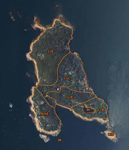
Fig. 31: USDA Soils map of Hurricane Island
LrB: Lyman-Rock outcrop-Tunbridge complex, 0-8% slopes
LrC: Lyman-Rock outcrop-Tunbridge complex, 8-15% slopes
LrE: Lyman-Rock outcrop-Tunbridge complex, 15-45% slopes
RmE: Rock outcrop-Lyman complex,15-80 % slopes
W: Water bodies
Hurricane soils are generally fine sandy loams overlain on bedrock or glacial till, with areas of loamy sands, peat, and clay. The range of pH on Hurricane is 4.5-5.5 in most places, although lime-rich clay (pH >8) is found beneath a shell and sand beach in one area on the northern shore of the island. The USDA soil series map for Hurricane Island (Figure 31) shows that topography is generally the most influential factor for the types of soils found on Hurricane Island (a topographic map is provided in Figure 32). This survey confirms the importance of topography, but also underlines the connection between topography and parent matierals from which soils are formed. Hurricane's valleys and depressions contain soils derived from glacial deposits, whereas soils on hilltops and steep slopes are composed mostly of organic matter and weathered granite. During a period of submergence following glacial retreat, marine clay was deposited beneath the sand beach on the island's north end.
Soil characteristics were determined by soil pit digging (approx 1.5 ft depth, where possible), paired with sampling of locations visited with a handheld soil borer (approx 1 ft depth). pH tests were performed in the field with a simple Truog Soil Reaction colorimetric test kit.
Five soil pits were dug in a variety of locations on the island in an attempt to capture the full range of soil conditions on the island. A summary of the soil pit characteristics follows. Figure 32 shows the location of the soil pits on the island.
North Beach lime & clay 1
North shore acidic sandy loam
Hilltop Soil Pit shallow acid soils
2 5 4
West Clearing Soil Pit sandy loam and glacial till
3
South shore ferric, weathered sandy loam
Final Depth: 12"
O: Little accumulation of organic matter: mostly thick knots of grass roots and moss.
A: lighter color resulting from bleaching and migration of mineral oxides to B layer
B: Darker in color, from accumulation of mineral oxides
Other notes: many large, rounded stones suggesting water-related weathering. Bedrock not encountered. Worms present.
Significant processes:
The north end of the island is likely to receive more overall precipitation reaching the ground as a result of its north-facing orientation (less evaporation) The soils here are loamier, suggestive of higher organic content and alluvial deposits.
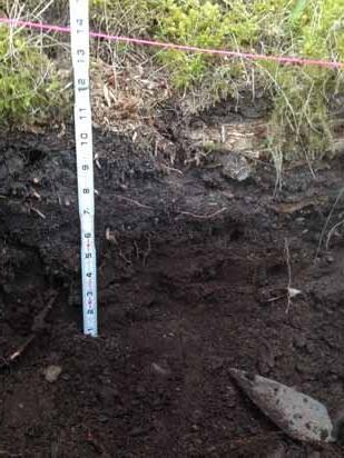
Soil pit #2: Sandy beach peat and clay
Final Depth: 20"
Thin layer of undecomposed organics and sand. Root fragments, peat. pH 8
Deep brown-colored sand and clay (clay 1 ) stained with organics. pH 6.5
Grey-blue clay (clay 2) with redoxomorphic features. pH 5.5
Significant processes:
shells,
sand clay 1 clay 2 0-8"
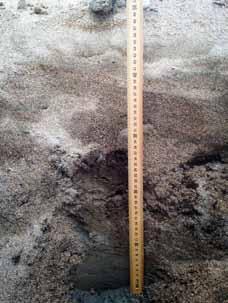
This unique statigraphy of soil types was only found in this sandy beach area on Hurricane. The first layer beneath the sand and shell mix is coarse sand mixed with organic matter, including undecomposed root fragments and organic debris. The high pH of this layer is a result of migration of dissolved calcium carbonate from the shells above. Each layer is progressively more acidic (minimum pH: 5.5 in the grey-blue clay) hinting again at the influence of the shells above. The clay at the base is extremely fine, and a column of the clay taken by a soil core and broken open appears mottled with blotches of red (see Figure 33 ). These are so-called "redoxomorphic" features - telltale signs of submergence in water, where only small, occasional pockets of oxygen develop to react with iron in the soils in an otherwise anoxic environment.
How did these two soil types get here? The clay is an artifact of the relatively brief window, geologically speaking, between the retreat of the Wisconsin glacier from the coast (ca. 15,000 years ago) and the uplifting of the land out of the sea a few thousand years later. For the time between those two events, the ocean followed the retreating glacier over land still depressed from the weight of the ice, reaching as far inland as Millinocket and well above present day Augusta and Bangor. Since clay, the smallest soil particle, can only settle out in deep, slow-moving water, the appearance of clay here underlines the fact that the north end of Hurricane was once under deep, still water in the period following the glacial retreat.
The organic soil between the clay and sand supports the notion that after a relatively rapid rise of sea level, the rate of sea level rise slowed, allowing vegetation to develop on the margins and slowly be buried as the water rose.1
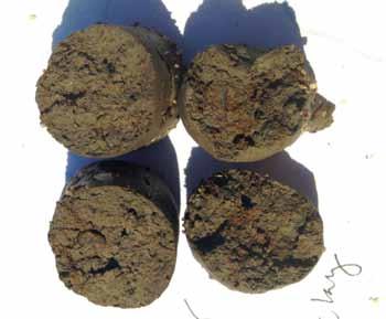
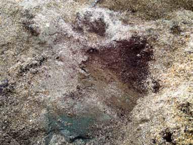
Final Depth: 20"
O: Thin organic layer, pH 4.5
A: grey-brown, pH 5.5
Anthropogenic layer, containing wood, coal, granite fragments, and glass - presumably from polishing shed.
B: Sandy loam with gravel and iron accretions. Ashy-grey. pH 5.5
C: Some gravel, sandy loam.
Significant processes:
The exposure of this aspect of the island to salt spray and high evaporation as well as the presence of the polishing shed on the southeast peninsula are the two most significant soil-influencing factors in this location. The disturbance of the soil by the structure - and the subsequent development of soil layer above the deconstructed shed - could provide an interesting study subject for postdisturbance soil development on Maine islands in the past 100 years.
Final Depth: 20"
O: Thin organic layer, mostly grass roots.pH 5.5.
A: Coarse loamy sand pH 5.5
B: Coarse loamy sand, pH 5.5. Wavy, uneven contact between A and B layers.
C: Coarse loamy sand, pH 5.5 - numerous jagged, sharp stones and cobbles.
Significant processes:
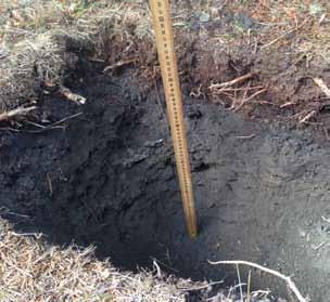
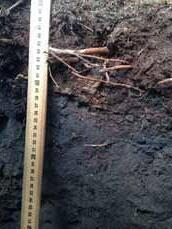
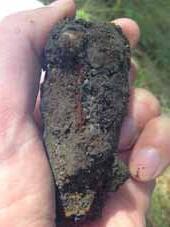
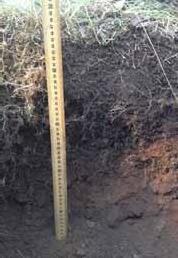
The wavy, uneven contact between the A and the B layers suggests the area was not plowed (a more uniform contact would be observed). The presence of sharp, jagged stones is characteristic of glacial till unweathered by water - in contrast to pits dug on the northern shore. Numerous worms encountered in this area, which is only 50ft or so from the garden area.
Final Depth: 5"
O: Thin organic layer of undecomposed spruce needles.
A: Brown-black, pH 5.5
E (?): Light-colored, bleached silica sand just above bedrock, pH 4-4.5.
D: Granite bedrock.
Though excavations in multiple locations were attempted, either the root masses were too thick to dig through or bedrock was reached, usually less than 8" below the soil surface.
The process of granite decomposition and the stratification of the degradation products are visible even in these shallow soils. Feldspars and micas are more easily weathered from granite, and are either used by soil biota and plants or washed out of the thin soil by water. The bottom layers of these soils are often bleached silica grains, and the pH is extremely acidic (pH 4-4.5).
1. Kelley, J. T., Belknap, D. F., & Claesson, S. (2010). Drowned coastal deposits with associated archaeological remains from a sea-level “slowstand”: Northwestern Gulf of Maine, USA. Geology, 38(8), 695–698. http://doi.org/10.1130/G31002.1
2. Great Lakes Worm Watch: Key to exotic earthworm species common in the Great Lakes region. Natural Resources Research Institute, 2011. <http://www.nrri.umn.edu/worms/downloads/identification/ dichotomous_key.pdf
Classifying areas by their natural communities is a more recent approach that many ecologists, governments, and other conservation organizations have adopted to describe a landscape. The concept of natural communities draws from the observation that various combinations of geology, hydrology, soils, and climate result in predictable assemblages of species and landscape features. Classifying an area as a particular "natural community" is done on the basis of all of these factors - soil, geology, climate, and plant species - and therefore is useful as a way to classify landscapes based on the underlying processes that shape a landscape over time, and not just by species or cover type.
Hurricane Island, as a single island among many similar granitic, exposed islands in the Penobscot Bay, hosts several natural communities typical for this area, as described in the manual for Maine Natural Communities, Natural Landscapes of Maine and also available online at http://www.maine.gov/dacf/mnap/features/commsheets.htm. Those natural communities are summarized here, with text from the maine.gov website:
Maritime Spruce-Fir Forest, state rank S4
"Red spruce, white spruce, balsam fir, and/or larch are dominant in this Downeast coastal type... Red and white spruce are the most typical dominants; northern white cedar or hemlock are rarely co-dominant. The canopy may contain gaps with regenerating red maple, paper birch, mountain-ash, heart-leaved paper birch, and fir....White spruce, bayberry, hay-scented fern, and mountain cranberry are indicators."
Low Elevation Spruce-Fir Forest, state rank S5
"Closed canopy (>75% closure) forests are dominated by red spruce (>60% cover), typically with few other tree species in any of the layers. Fir is often a minor canopy component (up to 20% cover), particularly in open gaps or in younger stands... Most of the ground surface is bare conifer litter, although at some sites (particularly Downeast Maine), bryophytes may form patchy to full cover."
Red Spruce-Mixed Conifer Woodland, state rank S4
"Mixed canopy woodland (25-70% closure) in which red spruce and/or white pine is always present and associated species vary... The shrub layer is typically very sparse (and variable in composition), and the herb layer has mostly 15-50% cover. Heath shrubs are the dominant feature of the herb layer; herb species rarely exceed 8% cover."
Rose Maritime Shrubland, state rank S4
"Medium height shrubs (1-2 m) usually cover 30-60% but may form dense thickets. Bayberry and roses are characteristic; raspberry and poison ivy are frequent associates"
Natural community descriptions relate to "ideal" examples of these assemblages; Hurricane's natural communities are, by contrast, heavily influenced by the presence of humans over the past few centuries. None of these community descriptions are truly a perfect fit, but justifications for each choice are presented in this document.
In the areas most heavily used by people over the past few centuries, no officially-recognized natural community description could be assigned: the assemblage there is a mix of grasses, cosmopolitan/non-native herbs, thicket-forming plants (raspberry, thistle, etc.), cultivated shrubs and trees, early-successional hardwoods, and more typical coastal trees and shrubs such as white spruce, bayberry, beach rose and juniper. For this reason, these areas have been assigned a composite community type, which generally grades into either Maritime Spruce-Fir Forests or Rose Maritime Shrubland. Additionally, areas with significant mortality of spruce-fir forests are noted, as they represent a significant landscape pattern large enough to merit inclusion on this map.
A separate section of this report (Hurricane's Spruce-Fir Forests) is devoted to the Maritime and Low-Elevation SpruceFir Forests, with special attention given to the question of why this community type exists here and a discussion of some pathogenicity and other issues relevant to management observed during the summer of 2015.
KEY
Maritime Spruce-Fir Forest
Low-Elevation Spruce-Fir Forest
Red Spruce-Mixed Conifer Woodland
Rose Maritime Shrubland
Mixed Canopy, Grasses, Shrubs
Spruce-Fir Mortality
Freshwater Pond
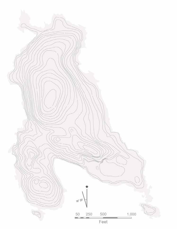
Maritime Spruce-Fir Forests are characterized by dominance of white spruce, with minor components red spruce, balsam fir and gaps regenerating with heart-leaved paper birch, mountain-ash, and red maple. Raspberries, hay-scented fern, and rough-stemmed goldenrod can be abundant in patches. This best describes the mixed forest type found along the coast, where white spruce often replaces red spruce in areas of higher exposure to salt spray and the canopy is only partially closed (<50% canopy cover).
» Mix (and generally, dominance) of white spruce as well as red, as opposed to total dominance of red spruce/fir
» Relatively open canopy (<50%)
» Heart-leaved paper birch, mountain-ash, in canopy gaps
» Bayberry mixed in with canopy cover
» Hay-scented fern, raspberry, rough-stemmed goldenrod locally abundant
This community type is characterized by a number of plants that thrive best in exposed maritime environments, which requires tolerance to both sunny and humid conditions, occasional salt spray and high winds. White spruce, of all the spruces, is best adapted to salt spray and the harsh exposure regimes of the coastal region. Graminoid cover in the understory may favor the regeneration of white spruce compared to red spruce, which was never found regenerating among grasses in this survey.
Characteristic species:
Hurricane's Variants
Common name
Canopy:
white spruce
balsam fir
mountain ash
heart-leaved paper birch
Shrubs & Small
Trees:
speckled alder
bayberry
rugose rose
Latin name
Picea alba
Abies balsamea
Sorbus americana
Betula cordifolia
Alnus incana
Myrica japonica
Rosa rugosa
Common name
Herbs: raspberry
rough-stemmed goldenrod
hay-scented fern
Bryoids: old man's beard
dicranum moss
three-lobed bazzania pincushion moss
Latin name
Rubus ideaus
Solidago rugosa
Dennistaedea punctilobula
Usnea spp.
Dicranum spp.
Bazzania trilobata
Leucobryum glaucum
Hurricane's maritime spruce-fir forests are generally consistent with the official descriptions of this community type. However, the presence of grasses, apple trees, numerous non-native plants, and human structures add a degree of variability to the range of species encountered in these coastal areas.
Speckled alder is a common feature of Hurricane's maritime areas, though this species is not included in the formal community description. Speckled alder, like bayberry, fixes its own nitrogen and thrives in sunny conditions with poor soils, often in saturated areas but is found on Hurricane growing in thin soils over bedrock.
Around areas where water collects and drains near the coast, several obligate wetland species are commonly found. No one drainage type is consistent with a natural community description, and there is enough variability among Hurricane's drainages that an independent category was not assigned. Species commonly found in coastal drainage areas are listed in Figure 39.
Common name
marsh shadbush
speckled alder
cinnamon Fern
interrupted fern
bueflag iris
marsh skullcap
narrowleaf blue-eyed grass
black grass
nodding sedge
sallow sedge
brownish sedge
Latin name
Amelanchier canadensis
Alnus incana
Osmundastrum cinnamomeum
Osmunda claytoniana
Iris versicolor
Scutellaria epilobiifolia
Sisyrinchium augustifolium
Juncus gerardii
Carex crinita
Low-Elevation Spruce-Fir Forests are characterized by a relatively closed (>75%) canopy where red spruce is dominant, with small patches of balsam fir (<20%) and occasional paper birch, and mountain ash in canopy gaps. Herbs are restricted to small patches of lowbush blueberry and scattered cover of Canada mayflower, starflower, and bunchberry. Ground cover ranges from bare conifer litter to patchy or full cover of bryophytes and lichens. Soils are rocky and shallow and typically very acidic (pH 4.1-5.2).
» Dominance of red spruce in a closed canopy (>75% canopy cover)
» Groundcover of bare conifer litter or partial to full bryophyte/lichen cover
» Acidic, rocky soils
Red spruce is slow-growing, shade-tolerant, and can tolerate wet, acidic, rocky soils with very little soil development - making it the best competitor for these sites. The constant humidity and higher exposure to wind on these hilltops filters out poor competitors that are found further downhill and in more protected areas (balsam fir, red/mountain maple, birch spp.).
Spruce-fir forests have likely been dominant on the coast as far south as the Penobscot Bay for thousands of years, even in times when spruce was far less abundant in the region due to a warmer, drier period when oak and pine were at a competitive advantage. The coast's "perhumid" climate, with moderated extreme temperatures and frequent drenching fogs, seems to be favorable enough for this forest type to maintain spruce during a time when the climate was generally warmer. For more discussion on this, see the Spruce-Fir Forests section.
Carex lurida
Carex brunnescens
Hurricane's low elevation spruce-fir forests are generally consistent with the official descriptions of this community type. Variability occurs on a smaller scale related to topographic and hydrologic features. On the north and east sides of Hurricane's two hills, bryophytes and/or lichens cover nearly all of the ground. On hilltops, southern, and western aspects, groundcover is generally bare conifer litter. On the north slope of the hill above the quarry pond, sphagnum spp. moss is especially abundant - unusual for an up-slope location without bedrock depressions. However, this is likely explained by the near-constant condensation of warm air as it moves up the heat-absorbing quarry face and cools as it reaches tree cover. Fog and sea-
Common name Common name
Canopy:
red spruce
balsam fir
Herbs:
Canada mayflower
bunchberry
starflower
lowbush blueberry
mountain cranberry
Latin name Latin name
Picea rubens
Abies balsamea
Maianthemum canadense
Chamaepericlymenum canadense
Lysimachia borealis
Vaccinium angustifolium
Vaccinium vitis-idaea
Bryoids:
old man's beard
cup lichen
dicranum moss
red-stemmed moss
three-lobed bazzania
breezes are blown in this same direction by predominant southwesterly wind.
Usnea spp.
Cladonia spp.
Dicranum spp.
Pleurozium schreberi
Bazzania trilobata
On the other slope, further north, the bryoid layer is composed of a stunning array of lichen species. Many of these are the fruticose Cladonia spp., which grow pedestal-like reproductive structures that add dimension and beauty to this microenvironment. Many lichens are known to have allopathic properties, which may help explain their near-total dominance of this shaded forest floor.
Further downhill, the forest briefly appears to grade in to a Spruce-Fir Cinnamon Fern Forest, also known as a Spruce-Fir Wet Flat. Here, a bedrock depression creates ideal conditions for peat mosses, cinnamon ferns, and other plants typical of saturated, acidic soils in full shade. However, the lack of diagnostic species such as leatherleaf (Chamaedaphne calyculata), mountain-holly (Nemopanthus mucronatus), rhodora (Rhododendron canadense), sheep laurel (Kalmia angustifolia) and the overall small extent of this variant weighed in favor of not designating this area as a separate natural community. Plants typical of this community that were found include cinnamon fern (Osmundastrum cinnamomeum), three-seeded sedge (Carex trisperma), creeping snowberry (Gaultheria hispidula), and black spruce (Picea mariana) or black-red spruce hybrids.
Red spruce-mixed conifer woodlands are patchy (25-75% canopy closure), conifer-dominated woodlands occurring on bedrock and thin, acidic soils (pH 4.6-5.2, soil depth <10in). The community description applies to areas where white pine and red or black spruce are co-dominant; here, spruce is dominant, mixed with early-successional hardwood species and shrubby trees. Shrub and herb cover is characterized by a mix of heath shrubs, bayberry, and shadbush (serviceberry). Fruticose lichens (reindeer lichen and others) form patches on bedrock.
» Patchy canopy cover (25-75% ), red spruce usually dominant
» Shrub community not typical of coastal or upland habitats, but a mixture of shrubs tolerant of nutrient-deficiency
» Very shallow soils (<10in), moderately acidic soils (pH 4.6-5.2)
» Patches of fruticose lichens (i.e. reindeer lichen) on exposed bedrock
Areas defined as this community type on Hurricane share a few common characteristics but do not all share the same history. Unifying ecological aspects of these areas include patchy forest cover with significant areas of exposed bedrock and a mixture of species, mostly dominated by red or black spruce. Spruce, once again, proves to be the superior competitor on shallow, acidic soils, but here is unable to form the dense canopies that lead to the development of the typical spruce-fir forest type. The higher levels of sunlight and drier conditions shift shrub, herb, and bryoid composition towards a different range of species than those found in typical spruce-fir forests. Trees are generally shorter and may appear stunted, as these areas, in addition to having thin soils which may limit root development and height, are also generally more exposed to wind and sun.
Characteristic Species
This community description is not in all cases a perfect fit for the areas I have delineated on the map. There are three types of areas categorized as this natural community that share the community's general characteristics but have very different disturbance histories.
On the island's northern hill (near Sunset Rock), there are several natural outcrops with patchy forest cover of red and black (or black/red hybrid) spruce with gaps occupied by a mix of huckleberry, blueberry, and fruticose lichens. This area, were it more extensive, might be considered a Black Spruce Woodland (S2). Although Slocum's trail runs through this area and Sunset Rock is a popular day hike destination, most of these areas appear generally undisturbed. The official town plan of Hurricane shows no buildings here and these outcrops do not appear to have been extensively used by Outward Bound. In this way, these areas may be the most "natural" representations of this community type on the island.
Common name
Canopy:
red spruce
black spruce
Shrubs:
bayberry
shadbush
Common name
On the Gaston Peninsula, this community type is mapped for similarly patchy, exposed areas with shorter trees and mats of fruticose lichens on bedrock. The island's only white pine was found here, with no saplings nearby - it seems unlikely that this species will ever be codominant with the spruce, as the official description of this community suggests is possible (though it is not a requirement that white pine be present for the community description to apply). Quarrying here, including several "motions" (smaller quarries for cobblestones) have left the area strewn with granite rubble, creating talus-like conditions in some places. Black spruce was not noted in this area, though white spruce is found closer to the coast. Creeping and common juniper (Juniperus horizontalis and J. communis) are also found along the groundcover here, with occasional black crowberry (Empetrum nigrum).
Herbs:
lowbush blueberry
bracken fern
On the quarry face, the general theme of exposed bedrock with patchy red spruce cover and thin soils still applies; but overall, the components here are more variable. Pockets in the bedrock created by quarrying allow small brackish ponds to form. Along the quarry face speckled alder thrives along with bayberry, shadbush, and heath shrubs. Below the quarry face, piles of granite slabs create talus piles that support typical talus vegetation such as rock polypody (Polypodium virginianum) and rock-tripe lichen (Umbilicaria spp.).
Bryoids:
reindeer lichen
dicranum moss
Latin name
Picea rubens
Picea mariana
Morella caroliniensis
Amelanchier spp.
Latin name
Vaccinium angustifolium
Pteridium aquilinum
Cladina spp., Cladonia spp.
Dicranum spp.
Moderately high thicket-like growth of shrubby roses, bayberry, raspberry and even poison ivy are characteristic of this community type, which is found throughout the Maine coast. Seaside plants are commonly intermixed with shrubs; lichens and mosses are generally absent except for crustose and foliose lichen growth on bare rocks. Soils in this community are generally acidic to moderately acidic (pH 4.8-5.5).
» Abundance of shrubby rose and bayberry, in clumps or thickets 3-6 ft tall
» Seaside plants: goosetongue, beach pea, etc.
» Crowberry and juniper present, but not forming extensive mats
This natural community is common where exposure to sea spray, high winds, sun exposure, and occasional storm waves limit tree growth. Characteristic species are generally well-adapted to seaside conditions, and may be out-competed elsewhere.
Hurricane's rose maritime shrubland is generally patchier and more mixed than, for example, that found on Little Hurricane Island - which is a great example of a maritime shrubland. On Little Hurricane, one has to wade through shoulder-high shrubs to explore just about any interior part of the island; on Hurricane, more than a century of high-intensity use of the coastal areas has fragmented these thickets and introduced a range of cosmopolitan species.
On the Gaston peninsula, the area mapped as rose maritime shrubland may actually approximate the Downeast Maritime Shrubland, also known as the Crowberry-Bayberry Headland, which has a state ranking of S2 ("Imperiled in Maine"). Extensive mats of creeping juniper, lowbush blueberry, and occasionally black crowberry and the more extreme exposure of this coastal area are characteristics this site
Common name
Shrubs
rugose rose
bayberry
raspberry
horizontal juniper
black crowberry
lowbush blueberry
Latin name Latin name
Rosa rugosa
Morella caroliniensis
Rubus ideaus
Juniperus horizontalis
Empetrum nigrum
Vaccinium angustifolium
shares with the Downeast Maritime Shrubland community. However, this site lacked sevearl diagnostic features of the Downeast Maritime Shrubland, including extensive mats of crowberry (juniper was more common), and threetoothed cinquefoil. Additionally, the Downeast shrublands are mapped only as "potentially" occurring in this region, and generally occur further northeast, whereas the rose maritime shrublands are common throughout the entire coast.
Rocky areas along the west and northwest shores of Hurricane, including Gibbon's Point, share many characteristics with the Open
Common name
Herbs: beach pea
Canada mayflower
yarrow
rough-stemmed goldenrod
Lathyrus japonica
Maianthemum canadense
Achillaea millefolium
Solidago rugosa
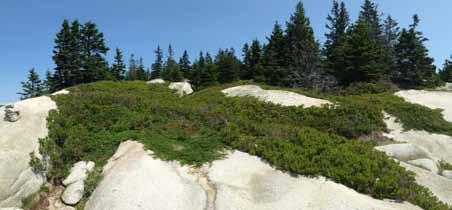
Headland (S4) community, which generally describes areas where seaside herbs such as goosetounge (Plantago maritima) along with small patches of creeping juniper and crowberry are interspersed with exposed bedrock along the coastline. While goosetounge, creeping juniper and crowberry are present in many of these exposed coastal bedrock areas, the absence of other diagnostic species such as rose stonecrop (Rhodiola rosea), and seaside goldenrod (Solidago sempervirens) reduced confidence in a designation of these areas as Open Headland communties.
A significant portion of Hurricane's coastline has been altered by the practice of dumping waste rock along the coastline, especially near the polishing shed and the wharves. These areas may have at one time been either shrubland or open headland communities. Now, grasses and white spruce abut the edge of this rock line on the southeastern shore.
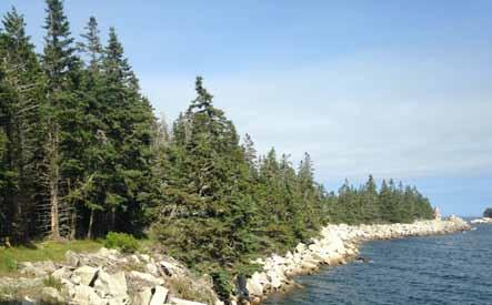
This designation does not refer to any official natural community, but rather is a label given to describe areas that are too heavily influenced by human use to fit a natural community description. General themes of these areas are an abundance of grasses and sedges, the presence of planted trees and shrubs, the presence of earthworms in the soil, and moderately acidic soil (4.5-5.5) of sandy loams and loamy sands. Elderberry, snowberry, apple, and other fruit-bearing shrubs are abundant here. Alder thrives in small clusters where water collects and/or bedrock is near the surface. Sensitive fern, bulrush, sedges and other facultative wetland species are common in small clusters where water collects. These areas grade into Maritime Spruce-Fir Forest, where white spruce forms patches of canopy with scattered bayberry and rose shrubs in the understory.
Humans, deer, birds, and grass all play a role in sustaining the meadow and shrub communities. Humans brought many of the species here on purpose (horsechestnut, elm, apple, lilac, valerian, timothy hay, etc.) and many others were likely transported by accident (many small herbs, earthworms). Deer eat just about anything palatable to them within reach, which often means that spiky, hairy, or otherwise unpalatable plants are given a competitive advantage. Deer browse helps explain why mullein, rubus, juniper, and thistle are all so common on the island, and fleshy species (i.e. jewelweed, bittersweet nightshade) are restricted to areas inaccessible by deer, such as under buildings or in steep ditches. Birds facilitate the spread of shrubby fruit and berry trees (elderberry, honeysuckle, highbush cranberry, etc.) by consuming the fruits and defecating elsewhere on the island. Last but not least, grass species play a very important role in the establishment of canopy trees: white spruce can regenerate in grassy areas, and red spruce cannot. With the decline of red spruce elsewhere on the island, the expansion of this community type is possible.
Early-successional hardwoods such as birch (Betula spp.) and aspen (Populus spp.) appear in small groves on Hurricane, primarily in sheltered, flat areas more recently regrowing from clearing. These trees are
intolerant of shade and germinate on exposed mineral soil, two qualities that generally require clearing by humans or some other natural disturbance event as a precondition to their establishment.
Birch catkins provide spring forage for numerous bird species. Since birch and aspen are both short-lived and have soft, easily decomposable wood, dead snags of these tree species are a reliable source of habitat for cavity-nesting birds (chickadees, woodpeckers, and northern flickers especially).
Characteristic Species:
Common name
Canopy:
white spruce
heart-leaved paper birch
horsechestnut
American elm
apple
Shrubs & Small
Trees:
lilac
bayberry
speckled alder
smooth shadbush
nannyberry
choke cherry
snowberry
Thicket-forming herbs
raspberry
Latin name Latin name
Canopy:
Picea alba
Betula cordifolia
Aesculus hippocastanum
Ulmus americana
Malus domestica
Syringa sp.
Morella caroliniensis
Alnus incana
Amelanchier bartramiana
Viburnum lentago
Prunus virginiana
Symphoricarpos albus
Common name
blackberry
goldenrod
Common herbs
skunk currant
orange hawkweed
cow vetch
common mullein
path rush
common wood rush common timothy
blue-grass spp.
sensitive fern bulrush
brownish sedge
Rubus idaeus
Rubus allegheniensis
Solidago spp.
Ribes glandulosum
Hieracium aurantiacum
Vicia cracca
Verbascum thapsus
Juncus tenuis
Luzula multiflora
Phleum pratense
Poa spp.
Onoclea sensibilis
Schoenoplectus sp.
Carex brunnescens
Manmade freshwater ponds introduce considerable diversity to Hurricane's flora and fauna. They also support mammal populations by providing drinking water and additional sources of food, as evidenced by abundant tracks near freshwater ponds. Amphibians such as red-backed salamanders (Plethodon cinereus) and a large and vocal population of green frogs (Rana clamitans ssp. melanota) are observed around these ponds. Diving beetles, backswimmers, dragonflies, and other insect populations also benefit from the presence of freshwater ponds on the island.
The freshwater ponds on Hurricane range in size and water clarity; the largest and clearest is the main quarry pond on the southeastern edge of the Island. Gulls frantically bathe and splash in this larger quarry pond, which is ringed by alders, birch, aspen, and other broadleaf trees and shrubs. Lichen-encrusted piles of quarry debris – talus, essentially – are used by the Island's raccoon population as denning sites, who also hunt for green frogs and other food in the nearby ponds. A few species of sunfish dart around in the shallows. A thicket of cattails encroaches on the northwestern edge of the pond,
Common name Latin name
narrow-leaved cattail
heart-leaved paper birch
trembling aspen
big-toothed aspen
speckled alder
bulrush
floating pondweed
Typha angustifolia
Betula cordifolia
Populus tremuloides
Populus grandidentata
Alnus incana
Schoenoplectus sp.
Potamogeton epihydrus
which is otherwise open. This pond also serves as a water source for HICSL.
The second quarry pond is shallower and generally more still. The gulls that bathe In the adjacent quarry pond do not (or rarely) visit this smaller quarry pond; tree cover around the perimeter is denser. In July, floating pondweed (Potamogeton epihydrus) blooms here.
A number of smaller, brackish man-made ponds are scattered throughout the island, each hosting somewhat unique plant communities as well as more generally providing habitat for green frogs, salamanders, dragonflies, aquatic insects as well as supporting bird and mammal populations with fresh water and food.
The largest brackish pond, known as the "ice pond" since it was harvested for cut blocks of ice during the quarry period, is ringed by grasses and supports a newly-discovered red-backed salamander population. These red-backed salamaders may exist elsewhere on the island, but may find the ice pond especially suitable because of the addition of protected overhangs and shallow caves in the granite just south of the pond edge (near "the Crack"), as well as the absence of fish species which might predate their egg masses. Several smaller ponds are found elsewhere on Hurricane, including one near Sunset Rock and one on the path leading up the quarry face.
Common name
Large Cranberry
Thread Rush
Toad Rush
Latin name
Vaccinium macrocarpon
Juncus filiformis
Juncus bufonius
Spruce-fir forests are the dominant forest type on Hurricane Island, occupying most of the slopes and hilltops above settlement areas. The exact extent of this forest cover is mapped in the Natural Communities of Hurricane section. This section describes how natural disturbances, human activity, and regeneration shape this community on Hurricane.
» Three natural communties of spruce-fir forests occur on Hurricane, distinguished by dominant species and relative canopy closure. Landscape patterns of these three forest types reflect land use history
» Wind and pathogens are the most common disturbance agents in the region
» The relative size of disturbance and surrounding vegetation influence revegetation trends
» Fires are historically uncommon on Maine islands, though they have occurred more frequently at high-traffic areas such as Acadia National Park. Climate change may increase the risk of fire
» Large patches of spruce on Hurricane Island are showing symptoms of mortality, and the exact cause is uncertain. Acid fog, pathogens, or nutrient deficiency may be involved, separately or together
» A few common plant, insect, and fungal pathogens found on Hurricane Island are identified
» Tree species distribution patterns on Hurricane are connected to ideal conditions for germination and growth
Red spruce on the shallow soils of Hurricane Island are especially susceptible to wind damage. Wind disturbance occurs on various scales, from gusts that remove individual trees to larger storms that clear an entire hillside. The effects of wind disturbance on species composition is a factor of scale and context. Smaller canopy gaps in interior areas caused by windfall are generally revegetated by spruce or fir saplings (Figure 46). In canopy gaps near forest edges, the presence of grasses, raspberry, and other aggressive species may hinder regeneration by red spruce and fir. Instead, quick-growing, shade-intolerant tree species such as birch and aspen are found in larger disturbance sites or in sites along forest edges. (Figure 47).
There are two larger canopy gaps (>.25 acre) caused by wind disturbance: one on the north end of the island by Gibbon's Point, and another in a valley on the eastern side of the island at Valley Cove.
Even though red spruce-fir forests are typically found in areas where fire is uncommon, fire risk in dry months may be a significant safety concern for Hurricane Island. Large fires have occurred on islands in the region. Significant portions of Mount Desert Island, which contains part of Acadia National Park, burned in a fire in 1947, where high fuel loading, high winds, and a short dry spell combined to increase fire risk in the weeks preceding the fire.4 Patterson et al. (1983) review the fire history on Acadia and regionally, and attribute an increase in frequency of fires in the past few centuries
to anthropogenic changes to forest conditions (i.e., logging) and to human activities (smoking, campfires, visitors to the Park).5 In a review of threats to Acadia National Park, Harris et al. (2012) note that fire continues to be a risk on Acadia, but also notes the lack of other studies besides the 1983 study.4 Recommendations for managing fire on islands of
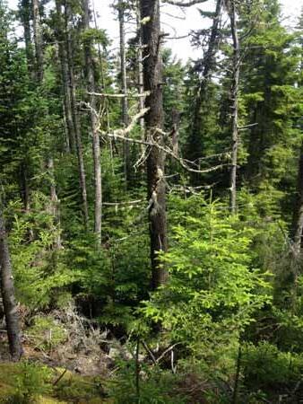
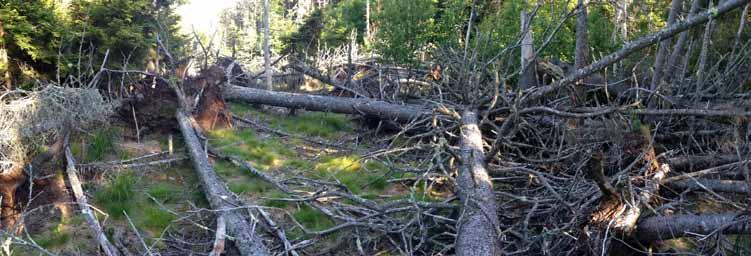
the Maine coast were not encountered in any sources consulted.
Additionally, an increase in summer temperatures with little or negative change in precipitation is predicted for the Maine coast as a result of climate change. See the Climate (part 2) section for a more in-depth discussion of projected ecological impacts related to climate change.
Fires, where they have occurred on Maine islands, generally result in a change in species composition to birch and poplar-dominated groves for several decades following the fire.3,4 Unlike black spruce, red spruce does not thrive in areas that experience frequent burning. Red spruce is shallow-rooted and highly flammable, and, most importantly, the cones of red spruce open fully and its seeds generally do not remain viable for more than a year. Black spruce seeds remain viable for several years inside the cones, which in some cases only open partially or not at all unless forced open by high temperatures. This trait allows black spruce to remain dominant in areas that are fire-prone1, while red spruce thrive in
not shown in detail, are established in the background.
areas that burn very infrequently.2 In a survey of spruce-fir forests of the Maine coast, Davis (1966) suggested that the climatic factors that favor red spruce display similar spatial patterns as the landscape patterns that prevent frequent fires (isolation, southwestern exposure), concluding “fire patterns would be expected to reinforce the same distribution of spruce-fir percentages which is expected on a climatic basis.”3
Several larger patches (>.25 acre) of Hurricane's forests appear to be dying, either a result of some pathogen or else some other cause, such as acid deposition, nutrient deficiency, winter injury, or poor soil conditions (Figure 48). The apparent clustering and radial spread of mortality seems suggestive of pathogenicity or some soil-related condition, but the underlying causes of spruce mortality cannot at this point be conclusively determined.
A few studies have measured acid fog deposition in connec-
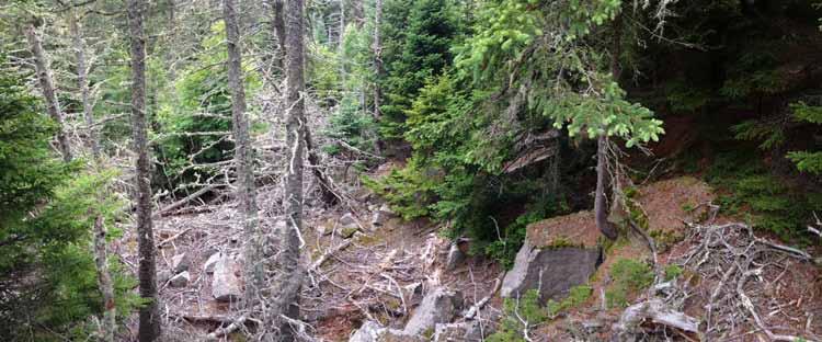
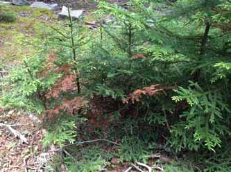
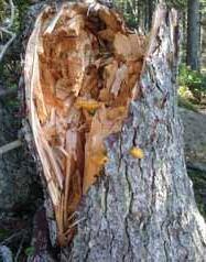
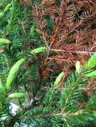
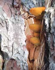
tion with symptoms of spruce decline in low-elevation forests on the Maine coast.6–9 The relatively high surface area of red spruce needles makes this species especially impacted by acid fog, a phenomenon observed both in low-elevation and high-elevation spruce-fir forests. In high-elevations, calcium deficiency and aluminum toxicity in connection with acid rain are suspected causes of spruce decline. However, fog in the Gulf of Maine has been shown to be more acidic than clouds on ridgetops in the northeast.10 Also, acid and ozone arriving to the coast in fog is exported from large urban areas like Boston and New York, which are growing in population and therefore may continue to pose a threat to coastal forests. For high-elevation forests, however, acid deposition has generally decreased since the passage of the Clean Air Act in 1990.
A more thorough study of spruce on the Maine coast and changes in soil conditions over time could yield insight as to the role of acid deposition, nutrient conditions, and spruce mortality in this area.
Cytospora canker (Figure 49) is a disease of spruce trees
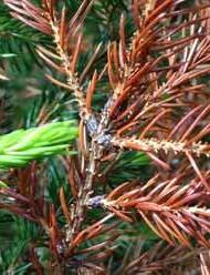
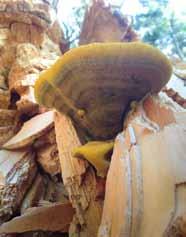
caused by the ascomycete fungus Leucocytospora kunzei (synonyms: Valza kunzei, Cytospora kunzei). The fungus is a common pathogen on several species of spruce trees, and though it does not generally cause outright mortality, it can weaken trees by causing significant branch mortality, potentially leading to tree death. The literature on Cytospora canker is not extensive, but some experiments have demonstrated that drought-stressed and damaged trees are more likely to develop cankers - the fungus itself is commonly found on healthy branches and only acts as a pathogen under certain conditions (in other words, it is an opportunistic pathogen).11,12 The cankers themselves are wounds caused by the fungus, and appear slightly sunken (on large branches). Wood may be visibly discolored around the canker, which itself is usually covered in resin, a defense strategy of the tree. The pathogen is spread by wind and water, but usually develops cankers only on damaged or stressed trees.
Phaeolus schweinitzii is another fungal parasite found on spruce (and other conifer) trees, identified easily when its bright yellow-orange, spongy fruiting bodies first emerge from or around the base of mature conifer trees (see Figure 50). As the fruiting body matures, it turns a dark brown color and becomes more planar (flat) and generally less dis-
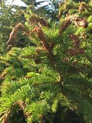
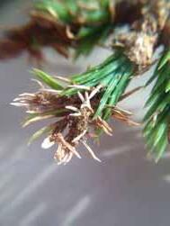
tinctive. This fungus parasitizes healthy trees, and causes butt rot that weakens the tree and causes early mortality, often by making the host tree more susceptible to windthrow.
Spruce budworm
Spruce budworm (Choristoneura fumiferana) is an endemic insect pathogen that, despite its name, generally feeds on balsam fir trees. However, during outbreak years, the spruce budworm will consume vast amounts of spruce and fir in the northeastern US and adjacent areas in Canada. As many as 11 spruce budworm outbreaks since 1704 have consumed balsam fir stands in the northeast.3 This combination of disease and predation is the major driver of stand turnover in balsam fir, and limits its mean age to about 70. Spruce budworm was detected on Hurricane island this summer, both as moths and as caterpillars (Figure 51). Spruce budworm damage was only detected on young white and red/black spruce; a more complete survey of spruce budworm on Hurricane could shed light on the extent of predation and the preference for spruce and fir species.
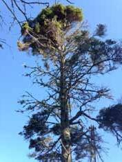
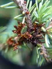
The dense clumping growth form seen on many of the island's trees, called a "witch's broom," is often caused by the small parasitic plant eastern dwarf mistletoe (Arceuthobium pusillum), which can be found growing out of the branches of infected trees. A. pusillum was only found on white spruce during this survey.
Dwarf mistletoe invades the spruce through specialized root structures called "haustoria," which grow directly into the host's xylem and phloem. Dwarf mistletoe is entirely dependent on its host for water, and gets a large proportion of its fixed carbon from the host as well. Its flowers resemble cannons, and in fact their specialty is, ultimately, in ballistic seed dispersal. Using cellular water pressure as a propellant, these tiny flower-cannons blast out seeds coated in a sticky substance that helps the seeds attach to the branches of their next downwind host.
A. pusillum is visible to the naked eye, but best viewed with a hand lens. On Hurricane, there are several spruce "brooms" with dwarf mistletoe low enough to the ground to see easily. The specimen pictured in (Figure 52, right) was found at waist height on the white spruce next to the boardwalk leading to the composting toilets by the dock.
The burls on spruce trees are formed by an entirely different type of nuisance: salt spray. Salt crystals embedded in the bark cause the tree to produce defensive inflammation around the affected area, resulting in large burls forming along the trunk.
Hurricane Island's spruce-fir forests are divided into three natural communities: Low-Elevation Spruce-Fir Forest, Maritime Spruce-Fir Forest, and Red Spruce-Mixed Conifer Woodland (Figure 54). These three communities can be summarized by the following general characteristics:
Low-Elevation Spruce-Fir Forests are dominated by red
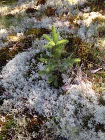
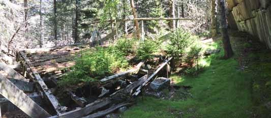
Maritime Spruce-Fir Forests are dominated by white spruce (Picea glauca), contain shrubs such as raspberry (Rubus idaeus) and rough-stemmed goldenrod (Solidago rugosa) in the understory, and have a moderately open canopy (>50% cover).
Red Spruce-Mixed Conifer Woodlands contain a higher variety of species and have more exposed, rocky areas than the
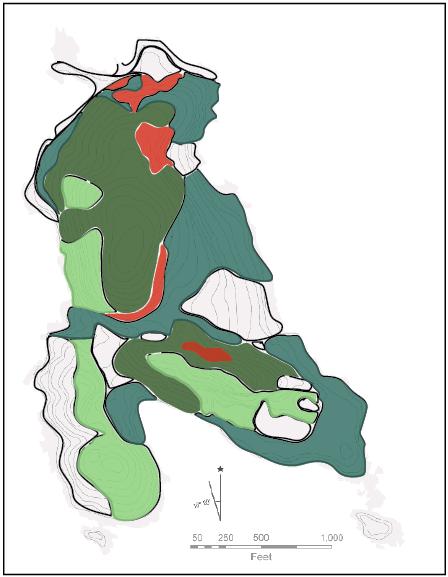

previous two communties. Canopy cover is patchy (25-75% cover).
Tree species have different, often very specific requirements for seed germination. Groundcover, moisture, temperature, competitor species, and light availability can all affect seed germination and survival. Differences in seed germination requirements between species help to explain distribution and successional patterns on the island.
Seed size is one of the most important variables in the survival and distribution of seedlings. As a general rule, the smallest seeds (birch, alder, and spruce) are the most vulnerable to drying out, and do best when in direct contact with mineral soil (as opposed to duff, moss, or herbaceous cover). Larger seeds (i.e. maple, mountain ash) have more stored energy, and can successfully germinate on leaf litter or duff.
Another important pattern observed on Hurricane Island is the effect of grass species on germination of red spruce compared to white spruce. Red spruce were not observed germinating in grassy areas, while this was common for white spruce. This pattern helps explain why the Maritime SpruceFir Forest type, which is characterized by a dominance of white spruce, generally occurs in areas near human occupation, where grasses are established in the understory.
Seedbed and germination conditions of key species are summarized here, along with a few general facts regarding habitat and growth. The Silvics of North America (available online) is a good source for ecological information on most common North American tree species, and is the primary source of information summarized below.13
Red Spruce seeds germinate best in mineral soil, rotting wood, moss beds, or duff (Figure 53). Because the seeds are small, they must remain moist during germination or
else they will readily dry out. Seeds germinating in mineral soil are in direct contact with the soil surface and therefore most likely to survive, whereas seedlings in duff or on rotitng wood may dry out more readily. Mast years occur every 3-8 years in this species. The light, wind-blown seeds can travel over 300ft. Few seeds remain viable for more than one year after dispersing.
Red spruce is very shade tolerant, and seedlings and saplings can remain in deep shade for decades until a canopy opening event (i.e., windfall of a nearby tree) induces a rapid growth response these "released" trees. Because of its tolerance for deep shade, limited nutrients, and thin or rocky soils, red spruce can form dense stands with few other species mixed in.
White Spruce seeds also germinate readily on exposed mineral soil, mosses, and rotting logs. However, white spruce is known to colonize abandoned fields and farmland in this region and compete successfully with grasses, raspberry, and other herbaceous species in sunny, open sites.14 White spruce was one of the first tree species in the grasslands that were established in the wake of the retreating glacier.15 This is an important distinction between red spruce and white spruce: red spruce was never observed germinating in grassy areas on Hurricane, whereas this was common with white spruce. This difference in germination habit is a key piece of the species distribution puzzle on Hurricane Island.
White spruce seeds are also light, wind-dispersed seeds capable of traveling >300 feet. Few seeds are viable after 1-2 years.
Black Spruce, found only in a few locations on Hurricane's northern slope and difficult in may cases to distinguish from red spruce, germinates best in exposed mineral soil, especially after fire or another significant disturbance. Black spruce seeds can also germinate in sphagnum moss or feathermoss, though with less success. Good seed years occur every 2-6 years, and seeds can remain viable in the cones, from which they are slowly released, for up to 25 years. The seeds are light and wind-dispersed, traveling up to 260 feet.
Balsam fir forms patchy, dense stands within areas dominated by red or black spruce. Balsam fir seeds can generate in a wide range of seedbed conditions, though mineral soil with some shade is best. Due to its small size the seeds are also susceptible to drying out on duff, wood, or moss substrates - though they may compete better with spruce on these sites, since balsam fir grows faster. Stands of balsam fir saplings and trees were observed most frequently in small gullies and steep valleys along the perimeter of dense red spruce stands on Hurricane.
Once established, balsam fir requires more light than the very shade-tolerant red spruce. This species is a vigorous
competitor that grows quickly. However, balsam fir stands usually succumb to disease or insects (especially spruce budworm, which preferentially feeds on this species) and thus most stands have a mean age of 70 years.
Heart-leaved birch also produces small, winged seeds that are dispersed by wind. Birch seeds are smaller than spruce seeds, and therefore birch seedlings are even more vulnerable to drying out. Survival is highest when germinating on mineral soil, though rotting wood and humus can support birch seedlings as well. Once established, birch is quickgrowing and intolerant of heavy shade.
The combination of an abundant, wind-dispersed seed supply and a preference for exposed mineral soil and full or partial sun explains the tendency of these birch species to appear in recently-disturbed sites. On Hurricane, birch is found in larger blowdowns and areas that have been recently cleared. Birch grows fast but does not live long, and is often replaced by slower-growing, shade-tolerant species like spruce, hemlock, or maple.
Aspen (bigtooth, quaking) Aspen seeds are light and dispersed by wind. Seeds are only viable for 2-4 weeks after dispersal. Exposed mineral soil is the best seedbed for these species. Once established, aspen species are quick growing and shade intolerant. Like paper and heart-leaved birch, the combination of these qualities make aspen species more common in recently disturbed sites where mineral soil has been exposed and competition is limited. However, unlike birch species, aspen species readily reproduce vegetatively through root suckers or stump-sprouting.
1. Harris, T. B., Rajakaruna, N., Nelson, S. J., & Vaux, P. D. (2012). Stressors and threats to the flora of Acadia National Park, Maine: Current knowledge, information gaps, and future directions. The Journal of the Torrey Botanical Society, 139(3), 323–344.
2. Patterson, W. A., Saunders, K. E., & Horton, L. J. (1983). Fire Regimes of the Coastal Maine Forests of Acadia National Park (No. OSS 83-3). Boston, MA: National Park Service, Office of Scientific Studies.
3. Davis, R. B. (1966). Spruce-Fir Forests of the Coast of Maine. Ecological Monographs, 36(2), 80–94. http:// doi.org/10.2307/1942150
4. de Lafontaine, G., Prunier, J., Gérardi, S., & Bousquet, J. (2015). Tracking the progression of speciation: variable patterns of introgression across the genome provide insights on the species delimitation between progenitor–derivative spruces (Picea mariana × P. rubens). Molecular Ecology, 24(20), 5229–5247. http://doi.org/10.1111/mec.13377
5. Lindbladh, M., Jacobson Jr., G. L., & Schauffler, M. (2003). The postglacial history of three Picea species in New England, USA. Quaternary Research, 59(1), 61–69. http://doi.org/10.1016/S00335894(02)00023-6
6. Jagels, R. (1991). Biophysical Aspects of Fog Deposition on the Needles of Three Conifers. Journal of Experimental Botany, 42(239), 757–763.
7. Jagels, R., Jiang, M., Marden, S., & Carlisle, J. (2002). Red spruce canopy response to acid fog exposure. 2nd International Conference on Fog and Fog Collection, 64(1–4), 169–178. http://doi.org/10.1016/ S0169-8095(02)00089-3
8. Jiang, M., & Jagels, R. (1999). Detection and quantification of changes in membrane-associated calcium in red spruce saplings exposed to acid fog. Tree Physiology, 19(14), 909–916. http://doi. org/10.1093/treephys/19.14.909
9. Jagels, R., Carlisle, J., Cunningham, S., Serreze, S., & Tsai, P. (1989). Impact of Acid Fog and Ozone on Coastal Red Spruce. Water, Air, and Soil Pollution, 48(1), 193–208.
10. Kimball, K. D., Jagels, R., Gordon, G. A., Weathers, K. C., & Carlisle, J. (1988). Differences between new england coastal fog and mountain cloud water chemistry. Water, Air, and Soil Pollution, 39(3), 383–393. http://doi.org/10.1007/BF00279483
11. Grabowski, M., & Kanner, C. A. (2016). Cytospora canker. University of Minnesota Extension. Retrieved from http://www.extension.umn.edu/garden/yard-garden/trees-shrubs/spruce-tree-diseases/cytospora-canker/index.html
12. Kamiri, L., & Laemmien, F. (1981). Effects of drought-stress and wounding on cytospora canker development on Colorado blue spruce. Journal of Arborculture, 7(5).
13. Burns, R. M., & Honkala, B. H. (Eds.). (1990). Silvics of North America: 1. Conifers; 2. Hardwoods (Vols. 1–2). Washington, DC: U.S. Department of Agriculture, Forest Service.
14. Loo, J., & Ives, N. (2003). The Acadian forest: Historical condition and human impacts. The Forestry Chronicle, 79(3), 462–474. http://doi.org/10.5558/tfc79462-3
15. Barton, A. M. (2012). The Changing Nature of the Maine Woods. Durham, NH: University of New Hampshire Press.
Hurricane is home to a diverse array of mammals, birds, amphibians, and insects: each of whom have their own role in the island's ecological processes. This survey is by no means exhaustive, and builds on significant contributions to the existing knowledge of these species by Hurricane employees, student groups, and visiting experts. Over time, the inventory of these species groups will continue to benefit from the expertise of the diverse spectrum of people who spend time on Hurricane. Suggestions on how this effort might be formalized and expanded are mentioned in the final section of this report, Protecting Hurricane's Resources
» Hurricane's mammalian fauna includes 4 common species, 1 unidentified bat species, 1 transient species, and probably other unconfirmed rodent species (mice)
» One species of salamander was newly identified on Hurricane, joining two species of frogs and one snake in the ongoing herpetological inventory of the Island
» Rock debris piles and freshwater ponds, both created by the quarry activities, increase habitat and food supply for raccoons. Voles, otters, and probably mink take advantage of rock/debris piles on the shore.
» Mammals reach islands through swimming (deer, mink, otter), occasional freezing of the Bay, and human transportation (raccoons, mice, earthworms).
» Overpopulation by raccoons is a nuisance for humans
» 26 families of flying insects were identified by a visiting entomologist
The Fox Islands were named by the English explorer Martin Pring who claimed to see foxes on there on his expedition to the Maine coast in 1603. There are probably no foxes on the Fox Islands today, but that doesn't make Pring's account untrue. The fact is that mammals swim, walk across ice, and regularly populate, vanish, and re-populate the islands of the Penobscot Bay. According to Conkling, west Penobscot Bay has frozen over solidly at least 3 times since 1700. Besides wild mammals, horses loaded with provisions made the journey across the ice during the last complete freeze of the western Bay in 1835.1 Of course, mammals are also are transported intentionally and accidentally by people.
In a survey of mammal species on islands in the mid-Coast region, Crowell (1986) determined that the "source pool" of mammals in the mid-coast region–those that could potentially migrate to islands under the right conditions–was 33 species. In a survey of non-volant mammals (i.e., excluding bats) on 24 islands in the Gulf of Maine, Crowell noted 11 mammal species on Vinalhaven Island (20 sq. miles, adjacent to Hurricane). By comparison, nearby Crotch Island (0.2 sq. miles) had three (and one additional but transient species, reported as “.5” by Crowell), and Mount Desert Island (107.8 sq. miles) had 29 species. Crowell concluded that island populations of mammals were maintained in equilibrium by a constant process of migration, extinction, and recolonization.2
Hurricane's mammalian fauna includes: white-tailed deer (Odocoileus virginianus), mink (Neovison vison), raccoon (Procyon lotor), meadow vole (Microtus pennsylvanicus),
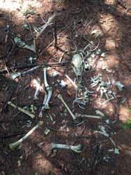
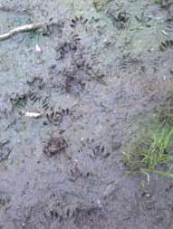
and an unconfirmed bat species (Myotis sp.). Mice also probably exist on the island, but no species have been identified yet. A river otter (Lutra canadensis) was observed once during this survey with two cubs on the southeastern peninsula emerging from a rock pile near the shore. However, subsequent game camera and tracking failed to detect continued presence of otter on the island.
All of these mammals are common in this area, but the raccoon would not be on Hurricane without the assistance of humans. Raccoons generally avoid deep water and are not known to swim to distant islands.
Habitat
Deer trails are easy to spot on Hurricane Island: especially
in the lichen and moss-coated hilltop near Sunset Rock, or in the dense balsam fir stands where pathways are repeatedly used. In fact, at times the difference between a deer trail and a trail made by people is at first unclear. There seems to be a steady population of deer, despite reports of a "removal" (unsolicited) by a sportsman the previous winter (2014) of nine deer. An adult deer can eat 6-8 pounds of vegetation a day for survival; the selective pressure on plant communities exerted by deer therefore is a strong one on an island with such a small area, resulting in an apparent skew towards thorny, hairy, or otherwise unpalatable species of plants on the island. They may also inhibit the regeneration of hardwood species such as red and mountain maple, of which there are only one individual each on the island. Browse is especially visible throughout the meadow-like and early-successional areas of the island - and, of course, by the garden.
Meadow voles prefer grassy areas, not surprisingly, where they tunnel through thick grasses and sedges. With no natural predators, the population of voles on Hurricane is particularly large, noted subjectively by the fact that many voles can be scuttling around, unafraid, around the piles of cobbles along the pathway leading north to Valley Cove.
Raccoons keep close to human activities on the island, raiding the compost bin (despite multiple attempts to secure it), unguarded coolers of visiting campers near Valley Cove, and near cabins. Denning sites can vary, but raccoon latrines and tracks were commonly found near the man-made talus piles by the main quarry pond. Tracks are found at almost all freshwater ponds, where raccoons may hunt for frogs, fish, and minnows. The raccoon population was culled in 2014 by island staff, but they continue to be a nuisance to guests and residents.
Mink are found more commonly along the island's perimeter, where they have easy access to an abundant supply of shellfish, crabs, and other intertidal prey species. They also inhabit abandoned buildings or structures. Their scat reveals their preference for marine species, though they may also hunt frogs, voles, mice, and occasionally birds. Mink and raccoon scat can be differentiated by diet, size, and the tendency of raccoons to re-use established 'latrine' sites, usually on the upslope side of a tree. Mink are more likely to defecate in exposed areas, such as on rock outcrops near the shore.
Otters were observed once on the island on the southeastern peninsula (from a distance close enough to confirm) and may occasionally den above the high tide line on a more secluded part of the shore. No den was detected in this survey. Otters are more transient than mink.
Bats are known on the island but no roosting locations have been confirmed. They most likely take advantage of building overhangs or other man-made structures.
A formal survey of the island's bird population was not conducted as part of this investigation, but surveys conducted by other groups provide a preliminary assessment of species present on the island. A checklist of bird species detected on Hurricane Island is provided in Figure 57. The list is a cumulative species list from HICSL staff as well as data collected by a wildlife field biology class from the University of Vermont in June 2015, led by Dr. James Murdoch and Dr. Alan Strong.
A few amphibian species were found on Hurricane Island. Green frogs (Lithobates clamitans) are the most conspicuous of Hurricane's amphibians, as they call loudly throughout the summer. An eastern red-backed salamander (Plethodon cinereus) was discovered under a rotting log by the "ice pond", the freshwater pond in the valley between Hurricane's two highest points. Several snakes have also been found on Hurricane Island (see Figure 56).
Reptile and Salamader Species Detected (2015)
Common Name
Reptiles
ring-necked snake smooth green snake
Amphibians
common gartersnake green frog
eastern red-backed salamander
Scientific Name
Diadophis punctatus
Opheodrys vernalis
Thamnophis sirtalis
Lithobates clamitans
Plethodon cinereus
HICSL was fortunate to host Kevin Keegan, a visiting entomologist, for one weekend during the summer of 2015. With the assistance of student participants of a weeklong Island Ecology program, Kevin conducted a quick survey of some of the flying insects on Hurricane. The specimens are identified to order and family in Figure 59.
A rapid assessment of Hurricane's earthworm species was conducted with the assistance of a visiting expert, Dr. Josef Gorres from the University of Vermont, who also assisted with soil pit evaluation.
Six species of earthworms of two genera were identified in two small soil pits in the meadow area between Hurricane’s two hills.
Apporectodea turgida
Apporectodea chlorotica
Apporectodea tuberculata
Aporrectodea rosea
Lumbricus terrestris
Lumbricus rubellus
*Only scientific names are provided, as common names for earthworms are not used widely or consistently.
Earthworms found in recently deglaciated regions, such as New England, are brought by humans in dirt used for ballast or plants. In broadleaf forest systems, introduced earthworms can be destructive to the organic horizon and leaf litter layer that many plants, such as sugar maples, depend on for germination. On Hurricane, though the worms are found in most of the island's deeper soils, it is not suspected that earthworms have any serious impact on plant communities. Understanding the extent of the earthworm presence and any patterns in worm species or plant communities would be an interesting project for a future researcher or student.
Cooper's hawk
bald eagle
black guillemot
long-tailed duck
common merganser
common eider
cedar waxwing
scarlet tanager
belted kingfisher
American crow
dark-eyed junco
song sparrow
white-throated sparrow
common loon
barn swallow
herring gull
ring-billed gull
greater black-backed gull
gray catbird
osprey
black-capped chickadee
common yellowthroat warbler
Tennassee warbler
northern parula
black throated blue warbler
yellow-rumped warbler
chestnut sided warbler
American redstart
black throated green warbler
blackpoll warbler
northern flicker
red-necked grebe
golden-crowned kinglet
red-breasted nuthatch
winter wren
Swainson's thrush eastern phoebe
Accipiter cooperii
Haliaeetus leucocephalus
Cepphus grylle
Clangula hyemalis
Mergus merganser
Somateria mollissima
Bombycilla cedorum
Piranga olivacea
Megacyrille alcyon
Corvid brachyrhynchos
Junco hyemalis
Melospiza melodia
Zonotrichia albicollis
Gavia immer
Hirundo rustica
Larus argentatus
Larus delewarensis
Larus marinus
Dumetella carolinensis
Pandion haliaetus
Poeacille atricapillus
Geothlypis trichas
Oreothlypis peregrina
Setophaga americana
Setophaga caerulescens
Setophaga coronata
Setophaga pensylvanica
Setophaga ruticilla
Setophaga virens
Steophaga striata
Colaptes auratus
Podiceps grisegena
Regulus satrapa
Sitta canadensis
Troglodites hiemalis
Catharus ustilatus
Sayornis phoebe
Accipitridae
Accipitridae
Alcidae
Anatidae
Anatidae
Anatidae
Bombycillidae
Cardinalidae
Cerylidae
Corvidae
Emberizidae
Emberizidae
Emberizidae
Gaviidae
Hirundinadae
Laridae
Laridae
Laridae
Mimidae
Pandionidae
Paridae
Parulidae
Parulidae
Parulidae
Parulidae
Parulidae
Parulidae
Parulidae
Parulidae
Parulidae
Picidae
Podicipedidae
Regulidae
Sittidae
Troglodytidae
Turdidae
Tyrranidae
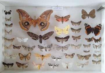
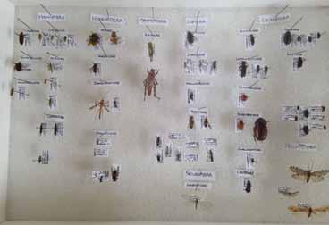
Flying Insect Families Collected on Hurricane Island in July 2016
Coleoptera
Elateridae
Gryinidae
Cerambycidae
Coccinellidae
Lampyridae
Scarabaeidae
Curculionidae
Carabidae
Trichoptera (two unidentified specimens)
Diptera
Tachinidae
Syrphidae
Sarcophagidae
Tabanidae
Neuroptera
Chrysopidae
Orthoptera
Acrididae
Hymenoptera
Apidae
Adrenidae
Ichneumonidae
Formicidae
Hemiptera
Lygaedae
Cercopidae
Miridae
Pentatomidae
Cicindellidae
Gerridae
Lepidoptera (Family ID unavailable)
Works Cited
1. Conkling,
2.
Having withstood probably several clearings, the comings and goings of a town of four hundred-some residents, intensive quarrying and heavy machinery, and then forty years of congregating, trail running and camping during the Outward Bound days, Hurricane’s natural resources are nothing if not tenacious.
That said, there are many signs of erosion and wear on many parts of the island as a result of current and past use. These erosive processes – as well as natural disturbances such as windfall and infrastructure maintenance/expansion – will inevitably expose and/or alter some historical elements of the island, and without a plan to preserve these features, valuable information about the history of Hurricane could be lost.
The following suggestions are made with the goals of biodiversity, historical preservation, sustainability and safety in mind.
This report is only the beginning, hopefully, of many years of natural history observation and documentation of Hurricane's ecology. In conversations with other naturalists who have spent time on Hurricane, many mention a sense of regret that some formalized system for keeping track of natural history observations on the island was not started sooner.
Today, the task of organizing and updating natural history inventories - and crowd-sourcing that information - is easier than ever. Services like iNaturalist and e-Bird are designed to allow easy data entry of species observations, and contribute to a global database that can be filtered for specific locations, time periods, and species.
With that in mind, there are a number of ways that HICSL can easily begin to keep track of species observations on the Island. HICSL can start accounts on either of those sites or ask visitors to record observations during their time here and upload their observations to one of those sites upon their return. Additionally, the contributions of visiting naturalists (of which there are many in a regular season, it seems) could greatly augment the specialized knowledge of the island. Developing a system around how to handle observational data - i.e., a Hurricane-only database that's stored on the website server, or else accounts on larger services like iNaturalist - could streamline that process and make collection of data easier.
Recommendations:
» Consider creating accounts for online naturalist services such as E-bird and iNaturalist.
» Develop a designated server location (public or not) on the website for uploading species observations.
» Host bird counts or 'bioblitz'-type events for other taxa (fungi, lichens, intertidal species) through conservation organizations
Topics of potential interest to students, visiting researchers, and local naturalists are listed in Appendix B
From a biological standpoint, soil is the key to sustaining complex terrestrial ecosystems: nowhere is that more apparent than on a granite island. The difference in the kinds of life forms that can survive on a half inch of soil and those that thrive on a few inches of soil is a difference of creeping mosses and thriving forests. While deeper soils exist in Hurricane's swales and valleys, most of the islands forests and coastal shrub and herb communities grow on less than seven inches of soil. These areas happen to be the most scenic parts of the island as well, and thus experience a heavy footfall by day visitors, staff, and student groups. Erosion on the North Beach area is especially visible, as access to the sandy beach carves multiple paths into the low bluff there, further hastening erosion. Social trails established on the hilltops can be both redundant and confusing, as they do not appear on the offical trail map and contribute unnecessarily to soil erosion.
Recommendations:
» Maintain the trail marking system (updated summer 2015) to ensure that all visitors follow the trails and avoid creating new social trails.
» This includes using only one fork (west fork) of Slocum's trail (blue) as it passes by the water tanks on sunset hill. New marking should reflect this recent change, but debris piles or ropes could help make it clear which fork is in use and which one is not.
» Make a single entry point for the sand beach on the north end of the island from the small ledge above to prevent trampling of the rest of bank, which is very visibly eroding.
» Leave blowdown areas unless they interfere with trail or other infrastructure. These habitats provide structural diversity and food supply for insects, birds, fungi, and mammals. This debris will also help build up future soils.
» Continue using woodchip mulch on roads and trail areas with bare rock exposed - consider this as an alternative to burning woody debris.
» Consider bringing mulch (find some spritely volunteers to help!) further up along the trails to slow vertical 'cutting' by trails
Hurricane’s forests, which probably cleared at least twice in the past few centuries, are now more uniform in composition and age structure, with a single canopy stratum of red spruce in most places and only pockets of dense, sapling-sized balsam fir and red spruce occupying smaller canopy gaps around the edges of the intact forest. Large swaths of red spruce have blown down on the east and north ends of the island. A decline in spruce is evident elsewhere in the forest, in large patches along forest edges. The large patches of spruce mortality suggest that parts of the island's forest composition may soon change.
The presence of large quantities of dead trees does present some concerns for fire risk and, possibly, infrastructure (though no immediate threats were observed to cabins or other buildings). No published work on management strategies to reduce fire risk were encountered in the process of this survey. So what can Hurricane do about managing its forests?
» Avoid thinning inside or near the edge of the current forest. This will only expose trees that have grown straight and thin to more wind damage. Experimental thinning of saplings could be done to reduce competition among young trees and increase the vigor and windfirmness of remaining trees.
» Gather perspectives from other island residents, especially about fire risk. While fire is not historically frequent in this part of the Maine coast (besides heavily-visited areas like Acadia National Park), the risk of fire increases with more debris left on the ground. The drawback to removing debris is that it slows the rate of soil formation, and also removes microhabitat for–among other things–regenerating red spruce. How have other islands dealt with this new stage of managing island spruce-fir forests? What have been the benefits/tradeoffs of their approaches?
» Study the spruce mortality; if the mortality is the result of climatic causes (i.e. acid fog or ozone), other islands and coastal areas may be affected too.
Since current maps of the island accurately document where the Outward Bound tent platforms are, it makes sense now to remove the ones that are most decomposed, as they present an actual safety hazard for anyone who might try to walk across them – some appear solid but are in fact highly decomposed and were built with no shortage of nails.
Morrow's honeysuckle (Lonicera morowii) is listed by the state of Maine as an invasive species. One well-established plant was located in the former quarry town area, near the former town hall. Scientists at Acadia National Park consider Morrow's
honeysuckle to be easy to remove, but serious in its potential impacts (see Harris et al., 2012, cited in Spruce-Fir Forests section, for more information).
Canada thistle (Cirsium arvense) is considered potentially invasive in Maine, and is established in one location near the showerhouse. This species may be difficult to remove, and is likely restricted to sunny, meadow-like areas. Bittersweet nightshade (Solanum dulcamara) is not listed by the state as an invasive or potentially invasive species, but some groups (such as Vital Signs, vitalsigns.gmri.org) consider this species invasive. Bittersweet nightshade was found in several locations near the buildings of Hurricane Island, but nowhere else.
Citizen science groups, like the Gulf of Maine Research Institute's 'Vital Signs' monitoring project, track invasive species in the region. HICSL should consider joining their effort to collect data on invasives in the region.
Hurricane Island is universally cited in literature about Maine’s quarry era, and also contains artifacts from previous occupations that shed light on how humans used these islands in early colonial times as well as before European settlement. As a historical site, Hurricane Island has much to offer to students, researchers, and the public. So how can Hurricane best preserve its historic qualities as resources for educational, research, and public use?
Many artifacts have been removed from the island from a century of visitors and use, but nonetheless finding artifacts –especially those from the “town that disappeared” – is still a relatively common occurrence on Hurricane. As more trees fall, old infrastructure is dismantled and new infrastructure is built, inevitably more and more artifacts are going to turn up and have to be moved or re-buried. As soon as they are moved, however, valuable information about where certain kinds of artifacts are found on the island is potentially lost. This spatial information can tell us much about the demographics, socioeconomic and cultural facets of the islands population over time – since there already exists a good record of who (or what kinds of people, generally) lived and worked where.
It cannot hurt and it can absolutely benefit HIF to start gathering a record of the identity and location of artifacts discovered on the island. This would be relatively easy to start doing and will cost HIF next to nothing to implement, save a few minutes of time when new artifacts are found. Additional benefits include:
» Strengthening future archeology programs/activities on the island (such as the one conducted in the summer of 2015) by using existing data to come up with more focused questions and hypotheses for projects/activities
» Attract and facilitate future research (for example: the doctoral candidate who attended Hurricane’s archaeology program and was, at the time, considering returning for part of this thesis work)
» Encourage researchers, local historians, and residents curious about the area’s past to get involved with HICSL to learn more about the island’s history
» Potential for creating simple but attractively curated displays of Hurricane’s history for visitors and participants
» Communicate and demonstrate an attitude of respect and scientific process in the way HIF interacts with the history of the island; by doing so, encourage others to do the same*
» Increase knowledge among staff and participants about the history of Hurricane and the plurality of the cultures that lived and worked here before HICSL
*Perhaps this goes without saying, but it should probably be made clear that artifact hunting (and of course, removal of artifacts from the island) is NOT encouraged or permitted by visitors, participants, or staff.
Collecting this information would only require some standardized data form and a place to tag and keep artifacts that would otherwise have been moved or disposed of. Data collection should be done using a system that would hold up to archaeological standards.
ii) Develop a preservation plan with the Maine Historic Preservation Office.
At the suggestion of faculty in the University of Vermont's historic preservation program, I recommend that Hurricane work with the Maine State Historic Preservation Office to develop a plan for conserving Hurricane's numerous historic features. This public office is established to help protect Maine’s historical resources, and could provide valuable consultation on data collection and archives, as well as best management practices for balancing safety concerns and historic preservation (i.e., open wells, chimneys with exposed lead flashing, etc.).
Appendix A: Vascular Plants of Hurricane Island as of August, 2015
Vascular plants of Hurricane Island, Maine (Knox County) were identified to species in June-August 2015. Some grass species (estimated 10 spp.) were not identified with confidence and therefore are not listed here. Taxonomic classifications, species names and authors follow the usage of the New England Wildflower Society’s Gobotany webpage (https://gobotany. newenglandwild.org/), which uses the more recent species names from Haines et al. (2011). Other sources consulted for identification are given below.
Key to Species Notes
† = invasive in Maine (DACF, 2013)
‡ = potentially or probably invasive in Maine (DACF, 2013)
§ = fewer than 3 individuals detected
Works Consulted
Magee, D. W., & Ahles, H. E. (2007). Flora of the Northeast: A Manual of the Vascular Flora of New England and Adjacent New York (2nd ed.). Amherst, MA: University of Massachusetts Press.
Maine Department of Agriculture, Conservation, and Forestry (DACF). (2013). Maine Natural Areas Program. Retrieved from http://www.maine.gov/dacf/mnap/
Newcomb, L. (1989). Newcomb’s Wildflower Guide. Boston, MA.
New England Wildflower Society. (2016). Go Botany. Retrieved from https://gobotany.newenglandwild.org/
Common
red-berried elderberry
nannyberry
highbush cranberry
speckled Alder
yellow birch
mountan paper birch
paper birch
grey birch
Morrow’s honeysuckle
snowberry
common juniper
horizontal juniper
bayberry
common lilac
balsam fir
white spruce
black spruce
red spruce
eastern white pine
mountain shadbush
swamp shadbush
smooth shadbush
apple
choke cherry
smooth rose
Scientific Name Family Note
Sambucus nigra L.
Sambucus racemosa L.
Viburnum lentago L.
Viburnum opulus L.
Alnus incana (L.) Moench
Betula alleghaniensis Britt.
Betula cordifolia Regel
Betula papyrifera Marsh.
Betula populifolia Marsh.
Lonicera morrowii Gray
Symphoricarpos albus (L.) Blake
Juniperus communis L.
Juniperus horizontalis Moench
Morella caroliniensis (Mill.) Small
Syringa vulgaris L.
Abies balsamea (L.) P. Mill.
Picea glauca (Moench) Voss
Picea mariana (P. Mill.) B.S.P.
Picea rubens Sarg.
Pinus strobus L.
Amelanchier bartramiana (Tausch) M. Roemer
Amelanchier canadensis (L.) Medik.
Amelanchier laevis Wieg.
Malus pumila P. Mill.
Prunus virginiana L.
Rosa blanda Ait.
Adoxaceae
Adoxaceae
Adoxaceae
Adoxaceae
Betulaceae
Betulaceae
Betulaceae
Betulaceae
Betulaceae
Caprifoliaceae
Caprifoliaceae
Cupressaceae
Cupressaceae
Myricaceae
Oleaceae
Pinaceae
Pinaceae
Pinaceae
Pinaceae
Pinaceae
Rosaceae
Rosaceae
Rosaceae
Rosaceae
Rosaceae
Rosaceae
§
§ *†§
* * § *
beach rose
blackberry
red raspberry
American mountain ash
steeplebush
big tooth aspen
quaking aspen
grey willow
red maple
mountain maple
horsechestnut
American elm
poison ivy
Scotch lovage
jack-in-the-pulpit
sarsaparilla
common yarrow
Canada thistle
field thistle
orange hawkweed
mouse-ear hawkweed
oxeye daisy
rayless chamomile
tall rattlesnake root
rough-stemmed goldenrod
American-aster
common dandelion
common jewelweed
smaller forget-me-not
common comfrey
sea rocket
wormseed wallflower
valerian
bouncing bette
field chickweed
blunt-leaved hrove-sandwort
knotted pearlwort
common chickweed
common bindweed
common dodder
bunchberry
moss stonecrop
brownish sedge
hoary sedge
hoary sedge
nodding sedge
sallow sedge
smooth black sedge
awl-fruited sedge
Rosa rugosa Thunb.
Rubus allegheniensis Porter
Rubus idaeus L.
Sorbus americana Marsh
Spiraea tomentosa L.
Populus grandidentata Michx.
Populus tremuloides Michx.
Salix cinerea L.
Acer rubrum L.
Acer spicatum Lam.
Aesculus hippocastanum L.
Ulmus americana L.
Toxicodendron radicans (L.) Kuntze
Ligusticum scothicum L. ssp. Scothicum
Arisaema triphyllum (L.) Schott
Aralia nudicaulis L.
Achillea millefolium L.
Cirsium arvensis (L.) Scop.
Cirsium discolor (Muhl. ex Willd.) Spreng.
Hieracium aurantiacum L.
Hieracium pilosella L.
Leucanthemum vulgare Lam.
Matricaria discoidea DC.
Nabalus altissimus (L.) Hook.
Solidago rugosa P. Mill.
Symphyotrichum sp.
Taraxacum officinale G.H. Weber ex Wiggers
Impatiens capensis Meerb.
Myosotis laxa Lehm.
Symphytum officinale L.
Cakile edentula (Bigelow) Hook.
Erysimum cheiranthoides L.
Valeriana officinalis L.
Saponaria officinalis L.
Cerastium arvense L.
Moehringia lateriflora (L.) Fenzl
Sagina nodosa (L.) Fenzl
Stellaria media (L.) Vill.
Calystegia sepium (L.) R. Br.
Cuscuta gronovii Willd. ex J.A. Schultes
Chamaepericlymenum canadense (L.) Aschers. & Graebn.
Sedum acre L.
Carex brunnescens (Pers.) Poir.
Carex canescens L.
Carex canescens ssp. disjuncta (Fern.) Toivonen
Carex crinita var. crinita Lam.
Carex lurida Wahlenb.
Carex nigra (L.) Reichard
Carex stipata Muhl. ex Willd.
Rosaceae
Rosaceae
Rosaceae
Rosaceae
Rosaceae
Salicaceae
Salicaceae
Salicaceae
Sapindaceae
Sapindaceae
Sapindaceae
Ulmaceae
Anacardiaceae
Apiaceae
Araceae
Arailiaceae
Asteraceae
Asteraceae
Asteraceae
Asteraceae
Asteraceae
Asteraceae
Asteraceae
Asteraceae
Asteraceae
Asteraceae
Asteraceae
Balsaminaceae
Boraginaceae
Boraginaceae
Brassicaceae
Brassicaceae
Caprifoliaceae
Caryophylaceae
Caryophyllaceae
Caryophyllaceae
Caryophyllaceae
Caryophyllaceae
Convolvulaceae
Convolvulaceae
Cornaceae
Crassulaceae
Cyperaceae
Cyperaceae
Cyperaceae
Cyperaceae
Cyperaceae
Cyperaceae
Cyperaceae
*‡ *§ § § *§ §
stalked woodsedge
black crowberry
creeping snowberry
black huckleberry
one-flowered Indian-pipe
lowbush blueberry
large cranberry
mountain cranberry beach pea
rabbit-foot clover
pinnate hop-clover
red clover
white clover
cow vetch
prickly gooseberry
skunk currant
pale St. Johnswort
common St. Johnswort
greater blue-flag iris
narrowleaf blue-eyed grass
toad rush
common soft rush
thread rush
black grass
common wood rush
split-lipped hemp nettle hooded skullcap
American twinflower
starflower
sweet-scented water lily narrow-leaved fireweed
dwarf enchanter's nightshade
northern willow-herb
common eyebright
narrowleaf cow-wheat one-flowered cancerroot
little yellow rattle
common yellow wood-sorrel
purple foxglove
common plantain
seaside plantain
common speedwell
creeping wild rye wheatgrass
common timothy
sheep sorrel
curled dock
ribbon-leaved pondweed
tall buttercup
tall meadow rue
wood strawberry
Scirpus pedicellatus Fern.
Empetrum nigrum L.
Gaultheria hispidula (L.) Muhl. ex Bigelow
Gaylussacia baccata (Wangenh.) K. Koch
Monotropa uniflora L.
Vaccinium angustifolium Ait.
Vaccinium macrocarpon Ait.
Vaccinium vitis-idaea L.
Lathyrus japonica Willd.
Trifolium arvense L.
Trifolium campestre Schreb.
Trifolium pratense L.
Trifolium repens L.
Vicia cracca L.
Ribes cynosbati L.
Ribes glandulosum Grauer
Hypericum ellipticum Hook.
Hypericum perforatum L.
Iris versicolor L.
Sisyrinchium angustifolium P. Mill.
Juncus bufonius L.
Juncus effusus var. soltus L.
Juncus filiformis L.
Juncus gerardii Loisel.
Luzula multiflora (Ehrh.) Lej.
Galeopsis bifida Boenn.
Scutellaria galericulata L.
Linnaea borealis L. ssp. americana (Forbes) Hultén ex Clausen
Lysimachia borealis (Raf.) U. Manns & A. Anderb.
Nymphaea odorata Ait.
Chamerion angustifolium (L.) Holub.
Circaea alpina L.
Epilobium ciliatum Raf.
Euphrasia nemorosa (Pers.) Wallr.
Melampyrum lineare Desr.
Orobanche uniflora L.
Rhinanthus minor L.
Oxalis stricta L.
Digitalis purpurea L.
Plantago major L.
Plantago maritima L.
Veronica officinalis L.
Elymus repens (L.) Gould
Elymus trachycaulus (Link) Gould ex Shinners
Phleum pratense L.
Rumex acetosella L.
Rumex crispus L.
Potamogeton epihydrus Raf.
Ranunculus acris L.
Thalictrum pubescens Pursh
Fragaria vesca L.
Cyperaceae
Ericaceae
Ericaceae
Ericaceae
Ericaceae
Ericaceae
Ericaceae
Ericaceae
Fabaceae
Fabaceae
Fabaceae
Fabaceae
Fabaceae
Fabaceae
Grossulariaceae
Grossulariaceae
Hypericaceae
Hypericaceae
Iridaceae
Iridaceae
Juncaceae
Juncaceae
Juncaceae
Juncaceae
Juncaceae
Lamiaceae
Lamiaceae
Linnaeaceae
Myrsinaceae
Nymphaeaceae
Onagraceae
Onagraceae
Onagraceae
Orobanchaceae
Orobanchaceae
Orobanchaceae
Orobanchaceae
Oxalicaceae
Plantaginaceae
Plantaginaceae
Plantaginaceae
Plantaginaceae
Poaceae
Poaceae
Poaceae
Polygonaceae
Polygonaceae
Potamogetonaceae
Ranunculaceae
Ranunculaceae
Rosaceae
wild strawberry
silvery cinquefoil
yellow bedstraw
Canada mayflower
eastern dwarf mistletoe
common mullein
long-leaved speedwell
bittersweet nightshade
narrow-leaved cattail
stinging nettle
eelgrass
Fragaria virginiana Duchesne
Potentilla argentea L.
Galium verum L.
Maianthemum canadense Desf.
Arceuthobium pusillum Peck
Verbascum thapsus L.
Veronica longifolia L.
Solanum dulcamara L.
Typha angustifolia L.
Urtica dioica L.
Zostera marina L.
Rosaceae
Rosaceae
Rubiaceae
Ruscaceae
Santalaceae
Scrophulareaceae
Scrophulareaceae
Solanaceae
Typhaceae
Urticaceae
Zosteraceae
hay-scented fern
bracken fern
mountain wood fern
sensitive fern
interrupted fern
royal fern
cinnamon fern
rock polypody
new york fern
marsh fern
Dennstaedtia punctilobula (Michx.) T. Moore
Pteridium aquilinum (L.) Kuhn
Dryopteris campyloptera (Kunze) Clarkson
Onoclea sensibilis L.
Osmunda claytoniana L.
Osmunda regalis L.
Osmundastrum cinnamomeum (L.) C. Presl.
Polypodium virginianum L.
Parathelypteris noveboracensis (L.) Ching
Thelypteris palustris Schott
Dennstaedtiaceae
Dennstaedtiaceae
Dryopteridaceae
Dryopteridaceae
Osmundaceae
Osmundaceae
Osmundaceae
Polypodiaceae
Thelypteridaceae
Thelypteridaceae
* * * * * *
The following is a brief list of questions that were generated as part of this inventory but not pursued as part of this project. These questions could be incorporated in to science education programs and hands-on projects, citizen-science inquiries, or academic research.
Wildlife:
» Conduct a thorough survey of herps (salamanders, frogs, and snakes) on Hurricane. How widely are they distributed and what factors explain where they are and are not encountered?
» Continued monitoring of bird populations, especially spruce-fir habitat specialists like the black-throated blue warbler (Setophaga caerulescens)
» Does Hurricane's meadow vole population fit the criteria of the Shattuckii sub-species classification?
» What is the extent of the earthworm "invasion" of Hurricane? Are there species differences in certain sites that could be traced to specific events or eras?
» What is the exact deer population on Hurricane, and what species are they browsing most heavily on?
» Additional detection of river otters through game cameras and tracking. Did they return to Hurricane after 2015?
Forests:
» What's causing the spruce mortality? Pathogens, nutrients, climate - or normal senesence?
» Monitoring of acid fog and ozone on Hurricane Island - ideally as part of a network of monitoring stations - paired with monitoring of winter injury and other signs of of spruce-fir forest mortality and 'spruce decline'
» Bioindicator lichen species survey for air pollution on Hurricane
» Monitoring of spruce mortality: how quickly is dieoff occurring, and in which directions?
» Regional study of health of low-elevation spruce-fir forests
» Tracking the colonization of new canopy gaps by spruce/fir regeneration versus shade-intolerant trees, raspberry and grass species. What factors influence regeneration trends?
» What is the extent of the spruce budworm presence on Hurricane, and are they preferentially feeding on some species more than others?
» How do Hurricane's upland forests get access to limited essential nutrients? Are shells dropped by birds (corvids and gulls) a significant source of calcium in Hurricane soils? Do lichens fix a significant amount of nitrogen for the forests?
» Are Hurricane's forests even-aged, two-aged, or truly mixed-age? What is the spatial organization of age classes on the island, and does that tell us anything new about the disturbance history here?
» Can additional landscape changes (forest composition, shrub/tree age) be correlated with time by a search through Outward Bound's photo records of the island?
» What archaeological period do Native American artifacts found on the north beach correspond to?
» When exactly was the north end of the island settled, by who, and for what purpose?
» A more complete inventory of Hurricane's graminoid species
» Survey of Hurricane's lichen and moss communities. Do factors such as forest age correlate with species composition or richness?
Coast:
» How extensive is the buried peat deposit under the north beach area?
» What effect do piles of quarried granite on the coast have on coastal ecology?
Fresh Water:
» Nutrient & water clarity comparisons between freshwater ponds: what factors explain observed similarities or differences?
» (Seasonal) - Surveys of breeding amphibian population