Blog Archives
A walk from El Portillo to La Fortaleza in the Teide National Park at flowering time
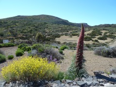
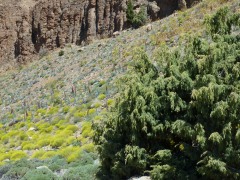
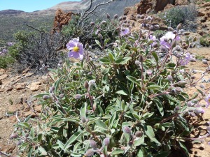
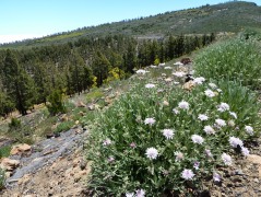
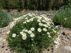
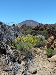
Left to right: Flixweed (Descourainia bourgaeana), Canary wallflower (Erysimum scoparium) and Teide vipers bugloss (Echium wildpretii), near the visitor centre at El Portillo
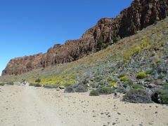
The scree slope beneath the cliffs of La Fortaleza is full of flowering plants, including the Teide vipers bugloss (Echium wildpretii) and Flixweed (Descourainia bourgaeana)

A group of mouflon, an introduced species of wild sheep, which are very shy and rarely seen. This was the first time I had seen them.
Again I do not have time to write a full walk description, although there is one in my book – Walk 32. It is a straightforward easy to walk route from El Portillo visitor centre.
I am just putting up pictures of the flowers in the area as they are at their best at this time of year.
A long-distance project – 4th stage of the Tenerife GR-131
We actually did this stage of the GR-131 in February, but for various reasons I did not get around to blogging it at the time. For this stage we did not have to hire a bus for the group, as we could use the public buses, and private cars. We decided to drive up to the Parador hotel in Las Cañadas, and take the bus to El Portillo to start the walk. There is only one bus a day which leaves the Parador at around 11.00, so we could not start the walk very early.
The signage for the GR-131 in the Teide National Park was completely lacking when I was investigating the route for this project. The red and white signage stopped at El Portillo and gave no indication of the onward section. We had to ask a Park Ranger for directions as we were not sure if the route went along the top of the Caldera wall, or along the bottom. The park ranger told us it went along the bottom, using National Park paths 4 and then NP path 5 to get up the caldera wall to the Degollada de Guajara. However, by the time we walked this section there was limited red/white signage to indicate the ongoing route.
From the junction at El Portillo where the bus stop is, a path goes down behind a noticeboard onto a path which continues below the road, but roughly parallel with it, till it joins a track which leaves the road opposite the National Park Visitor Centre. This is NP path 4, and is a track all the way to the road beyond the Parador. So we turned left on the track and started our walk along it along the base of the caldera wall.

Cedros up the caldera wall, (Juniperus cedrus), the high mountain species of juniper endemic to the Macronesian islands
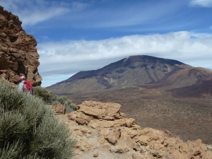
I am not a great fan of walking on tracks in Tenerife, as sometimes they are very rough underfoot, and often boring as they wind their way through countryside a footpath would go straight through. However, this track was mostly very easy to walk on, and it certainly wasn’t boring. The scenery unfolded new vistas with each step, with the views to Mt Teide changing from the north side to the south eastern, and the caldera wall providing a continuously changing panorama of rock types and colours. Not to mention the lava mounded up in some parts of Las Cañadas to the right of the track.

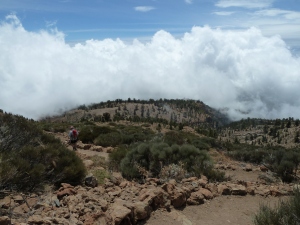
The track approaching the area with the shepherds’ huts and the Teide Viper’s Bugloss. Note the beautiful cloud formations
About half-way along the track I enjoyed watching a pair of Great Grey Shrikes darting around among the Mt Teide broom (Spartocytisus supranubius) plants. They are fairly common in the National Park and have a habit of returning to a prominent place such as the top of a bush, or rock, to look for prey. They then dart out to catch things and return to their perch. This makes it easier for an amateur like me to get a photo, even if a bit fuzzy due to the distance!
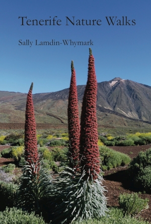
A bit further on there is an open level area below a pinnacle on the caldera wall with a scree slope beneath. At the foot of the scree slope are the remains of stone buildings where in the past shepherds sheltered in their summer stays in Las Cañadas. And up the scree slope in February the skeletons of the previous summer’s blooms of Teide Viper’s Bugloss (Echium wildpretii) were visible. Clearly this area is much favoured by this iconic Canary endemic plant with flower spikes up to 3m high in May/June.
Continuing on the track we came to the path junction with NP path 5 going left up the caldera wall. We did not take it this time, that will be done on the next stage of the GR-131. This time we continued along the track till the NP path 4 turned right towards the Parador.
The walk was 16.7km/10.4miles long, with 255m/837ft of ascent, mostly gentle climbs. It took me nearly 4 hours, though several of our fast walkers were considerably quicker. This was, of course, on a cool day with some snow lying under bushes, so in warmer conditions it could well take longer. In May and June, of course, the walk would be brightened by the floral displays from the local very specialised flora, but I was amazed how colourful and interesting it was even without the flowers.
A challenging walk from the Parador to Villa de Arico
This walk involves starting in Las Cañadas at the Parador hotel at 2100m/6895ft altitude, climbing up to the caldera rim and over Mt Pasajiron at 2529m/8305ft and then descending over 1800m/5910ft to Villa de Arico. It was about 23.5km and took 2 people 6.75hours. So if you are not up to this kind of strenuous walk do not attempt it, especially as most of the way you are nowhere near a road or habitation. The other main difficulty with this walk is that it is linear and that neither end is particularly easy to access by bus. So, having told you all the disadvantages, now let me tell you that it is an excellent walk, with varied landscapes, exceptional views, and good clear, well signed paths with good walking surfaces. We both thoroughly enjoyed the experience.
We caught the 342 bus from Los Cristianos to the Parador, which meant we were not able to start walking till 10.45. When we arrived there was a biting cold wind, and it was cloudy, so it felt very cold. We had a brief look at the signboard at the turning circle by the Parador for this walk, the PR-TF-86. As soon as we were ready we set off at a good pace to try to get warm. We were familiar with the first part of the walk, on National Park path 4 across to the track and then left along the track for 3 km, so we walked fast. At times we were sheltered from the wind and it felt a lot warmer.
After 45 minutes of hard walking we reached the turning right off the track onto path 5 to climb the caldera wall to the Degollada de Guajara. The path zig-zags up the slope and took us about 25 minutes to climb. As we climbed some snowflakes started to drift in the wind. We looked across at Mt Teide nearly covered in dark cloud, and wondered what we were doing! Just before we reached the top we put on all our layers as we knew on the ridge the biting wind would be at its worst. Then we immediately turned left to begin the climb of Mt Pasajiron. By now, fortunately, the sun was trying to break through the cloud on our side of the caldera, and the cloud was beginning to lift from Mt Teide over the other side, so it was looking brighter.
We had walked this bit of the walk only once before, four years ago when the path was much less defined than now, and we got lost just after passing the top of Mt Pasajiron. This time it was a relief to see the well-defined and easy to walk path zig-zagging down from the peak and up the other side of a valley. The relief, and the fact that, in the valley out of the wind, the sun made us feel more relaxed, gave me a little time to look around at the plants. Up there near the edge of the caldera rim is a very special selection of plants, survivors of freezing winds and blazing sun. Of course, barely anything was in flower because it was a bit early anyway, and because of the very dry winter, but I could see there were some rare plants, including the very local endemic false sage, Sideritis eriocephalus, and the Teide knapweed, Cheirolophus teydea. In addition, on a very exposed high point of the next rocky outcrop, a fine specimen of the Cedro, Juniperus cedrus, the juniper of the high mountains.

A good example of a Cedro tree (Juniperus cedrus) the high mountain form of juniper on an exposed ridge
Having climbed out of that valley we started to look for the junction of paths where we knew we had to leave the National Park path 8 and turn right, and downhill to go to Arico. We reached the junction one hour and three-quarters after starting walking. Although there was no signpost, it was well marked, with the yellow/white livery of the PR-TF-86, showing both the way to go, and crosses showing where not to go. We started down the hill till we crossed an old track and found a spot in the sun and out of the wind to have our lunch. We were enjoying wide views to each side and downhill, but only so far, as a cloud was gathering at a lower level, in the pine forest zone.
We continued downhill towards the pine forest we could see ahead. We passed through an area where there were a lot of flakes of obsidian in the path and the land around. The landscape dominated by the Mt Teide Broom (Spartocytisus supranubius) gradually gave way to pine trees, and we even saw a few white flowers among the Escobón (Chamaecytisus proliferus) in the understory. Some of the pine trees were very large and clearly ancient, and under a group of these were some old shelters or corrals for animals. We continued down as the cloud began to restrict our views, but it was not uncomfortably thick.
At an altitude of about 1900m the path crossed a dry riverbed immediately above a dramatic canyon. Around the edge of the canyon were more Cedros (Juniperus cedrus). By now we had passed a number of junctions of paths going left and right, arousing our interest about where they went, but we continued on down following the yellow/white paint markers. A bit lower down the path re-crossed the riverbed, this time at a point where the far wall was a near vertical smooth face of rock.
Soon after this we started to come into contact with signs of civilization in the form of a well-used driveable track which we crossed and re-crossed several times from then on. Now the path junctions had signposts, as we were nearing the small settlement and barbecue park at El Contador. As the path zig-zagged down a steep slope under pines, I saw the first flowers for several miles, a Tenerife Bird’s Foot Trefoil (Lotus campylocladus). We had passed thousands of bushes of Pine Forest Cistus (Cistus symphytifolius) which should have had signs of flowers, but were all shrivelled and dry.
We had now reached the paths we knew from walks in the area of the Parque El Contador, so the route was now familiar. We crossed the dirt track for the last time and came down onto a ridge above El Contador. We were now below the cloud, and feeling a bit warmer. Descending to the level of El Contador, we crossed the narrow tarmac access road and started the final bit of descent, gradually coming out of the pine forest, through open country and finally down to farmland. We took the detour left (not signposted, but with yellow/white markers) which passes along a scenic section of the Barranco de los Andenitos. Then rejoining the path down a ridge we continued to the junction where there is a choice of paths to Ortiz. We chose the left one, along the ridge. The right one goes down into the streambed of the same very scenic through a section popular with rock-climbers.
Reaching the road bridge on the edge of the village of Ortiz we found the signpost to Villa de Arico, which had previously been there, removed. The footpath was blocked by rows of rocks daubed with paint slogans such as ‘stop’ and ‘privado’. I had read about a problem with one particular landowner hereabouts, but we pressed on along the left bank of the barranco from the bridge, negotiating all the obstacles. It was clear many other walkers had done the same, and eventually the path became unobstructed again. However, easy walking was not to last long, soon we started a steep zig-zag section descending a rocky ridge. The path was very rough and required a lot of attention to avoid accidents when we were already tired, so we were glad when the path left the ridge, crossed the barranco, climbed up the other side and joined the tarmac road entering Villa de Arico.
We arrived at the main road just 15 minutes late for the bus we had hoped to catch. Thinking we could catch the next one 2 hours later, we had a very pleasant meal in a bar. Unfortunately the expected bus did not come. Meanwhile we could have caught a bus down to Poris de Abona on the coast and caught the express motorway bus back to Los Cristianos. That would have been quicker than what we actually did which was to take a taxi to Granadilla and a slow bus to Los Cristianos from there. I don’t think our minds were working very well after all the exertion, but we did get home eventually!
