
- The Camargue
The Camargue (in Occitan Provençal: Camarga according to the traditional standard or Camargo according to the Mistralian standard) is the marshy area formed by the Rhône delta.
This land area spans 145,300 ha in the south of France, located between the two main arms of the Rhône Delta and the Mediterranean Sea. It extends to the Crau Plain in the east, Aigues-Mortes in the west and Beaucaire in the north. It thus extends over the departments of the Bouches-du-Rhône and the Gard.
There are 3 parts:
- the Petite Camargue to the west of the Petit-Rhône,
- the Grande Camargue, between the two arms of the Rhône,
- the Plan du Bourg, east of the Grand-Rhône.
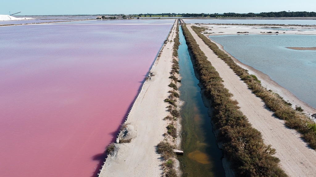
In its center is Vaccarès Lake, and the section located along the sea is lined with salt ponds.
The Camargue is essentially located in the area surrounding Arles, which makes it the largest commune in metropolitan France, from Saintes-Maries-de-la-Mer to Port-Saint-Louis-du-Rhône.
This region is composed of two parts: the north is agricultural land and the south is composed of marshes and salt water bodies that form a special ecosystem.
The vegetation is mainly composed of saltwort and halophilic plants (i.e. plants that tolerate salt water) such as saladella.
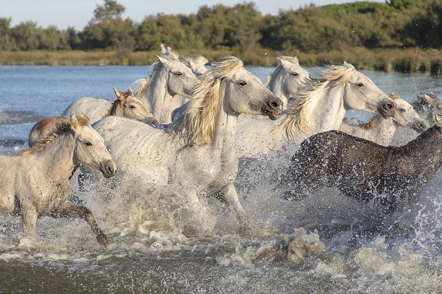
It is also an area of horse and bull breeding, rice cultivation and salt harvesting (salt marshes).
This particular plant and animal life led to the creation of a national nature preserve covering 13,117 hectares (1927) and a regional natural park covering 30,000 hectares (1970).
There is more annual evaporation than rainfall. The river makes up the difference, preventing the region from being burned by the salt.
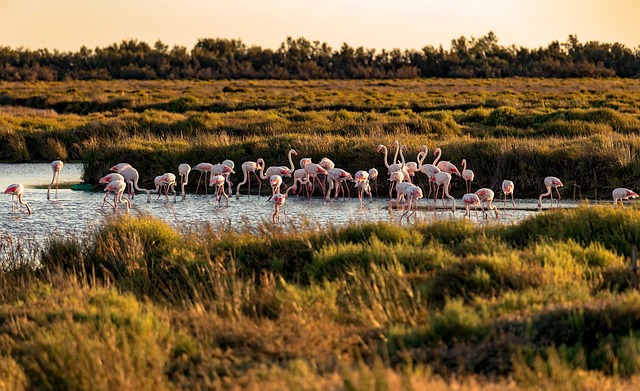
The Camargue is very important on the national and European level for local birds, both migratory birds and winterers. In 2000-2005, it was the biggest French site in terms of the number of winterers hosted each year (122,000 birds, ahead of the Arcachon basin which hosts 105,000).
Camargue Regional Natural Park
The Camargue Regional Natural Park was created in 1970.
The manade ranchers wanted to promote the Camargue breed of horse, as well as the AOC Camargue Bull, bred from two cattle breeds, the Camargue and the Brave.
In the future
The Camargue coasts are undergoing an intense transformation, with zones of maritime erosion around Saintes-Maries-de-la-Mer and in front of Faraman, and widening zones mainly towards the mouth of the Grand Rhône, Beauduc and the Espiguette Lighthouse (Grau-du-Roi). It should also be added that the entire delta and lowlands are beginning to suffer the effects of global warming: increase in salt due to rising sea levels, etc.
The Camargue is also a political and economic issue for multiple stakeholders: the Camargue Regional Natural Park, administrative departments, real estate developers, land developers, Salins du Midi, ranchers, farmers, hunters, tourism professionals, organizations for the protection of the Rhône, the municipalities of Arles and Saintes-Maries-de-la-Mer, the regional authorities, etc.
Places in or near the Camargue
At the gateway to the Camargue and Petite Camargue
- Arles
- Grau-du-Roi
- Beaucaire “northern gateway” to the Camargue
- Tarascon “northern gateway” to the Camargue
- Nîmes
- Fourques
- Bellegarde
- Aimargues
- Saint-Laurent-d’Aigouze
- Aigues-Vives
- Saint-Gilles
- Gallician
- Franquevaux
- Le Cailar
In the Camargue
The Camargue in its most restrictive sense is located between the two arms of the Rhône delta
- Trinquetaille (district of Arles)
- Les Saintes-Maries-de-la-Mer
- Salin-de-Giraud
- Port-Saint-Louis-du-Rhône
In the Petite Camargue
The Petite Camargue, to the west of the current delta, corresponds to an area formerly occupied by the disappearing arms of the Rhône that fed the Languedoc coast, between Beaucaire and the sea.
There are still historical traces of this configuration, probably with a delta that had already begun to tilt towards the east (over time, the mouths of the Rhône have moved from west to east):
- the Spanish branch is mentioned by Latin authors
- and more recently in the Middle Ages, the arm that used to pass under Saint-Gilles before being absorbed by the ponds connecting to the sea near today’s Grand-Motte and Maguelonne.
Nowadays, the Petit Rhône, which is in the process of drying out, can be considered as a remnant of this historical branch, at least in its upper course from Arles to Saint-Gilles.
Article sources from Wikipedia