
Fire History (1896–2013) in an Abies religiosa Forest in the Sierra Norte of Puebla, Mexico

 , and
, and
Abstract
:1. Introduction
2. Materials and Methods
2.1. Study Area
2.2. Tree Sampling
2.3. Laboratory Methods
2.4. Data Analysis
2.5. Climate-Fire Relationship
- A local dendrocronological series based on Pinus patula [Schlechtendal and Chamisso] annual tree-rings from 1905–2011 [44].
- The Winter Index (December-February) NIÑO 3 related to El Niño Southern Oscillation (ENSO) [45] and
- The Palmer Drought Severity Index (PDSI) June-August (1900–2012) for the point closest to our study area, information extracted from the MXDA [46].
3. Results
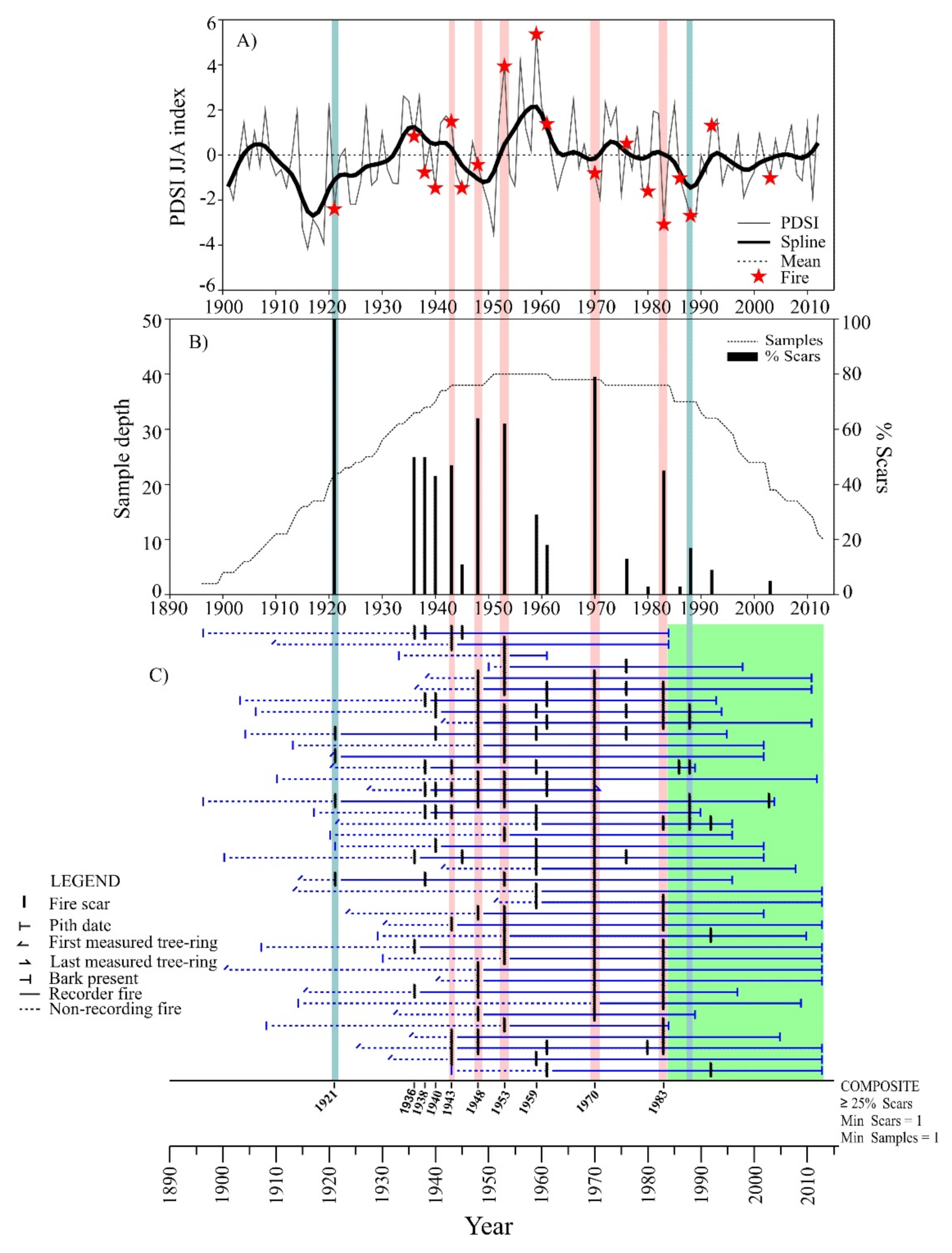
3.1. Fire Frequency
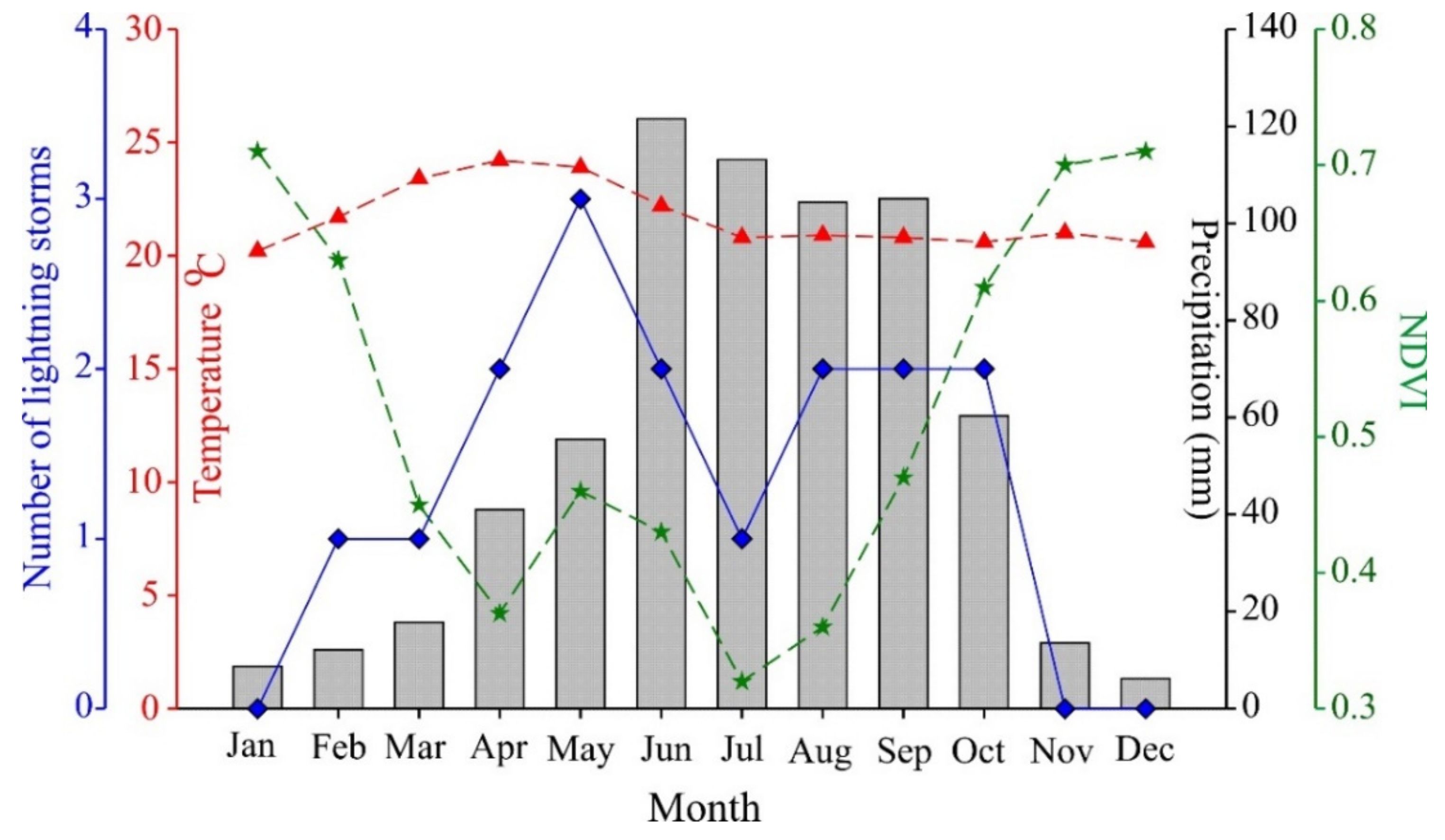
3.2. Seasonality of Fires
3.3. Climate-Fire Relationship
4. Discussion
4.1. Fire Seasonality
4.2. Fire Frequencies
4.3. Climate-Fire Relationships
5. Conclusions
Author Contributions
Funding
Institutional Review Board Statement
Informed Consent Statement
Data Availability Statement
Acknowledgments
Conflicts of Interest
References
- Cuevas-Guzmán, R.; Martínez-Rivera, L.M.; Cisneros-Lepe, A.; Sánchez-Rodríguez, E.V.; Guzmán-Hernández, L. Ordenación y clasificación de los oyametales del estado de Jalisco, México. In Ecología, Manejo y Conservación de los Ecosistemas de Montaña en México; Sánchez, L.R., Galindo, J., Díaz, F., Eds.; Mundi-Prensa: México D.F., Mexico, 2008; pp. 212–227. ISBN 9789687462578. [Google Scholar]
- Sáenz-Romero, C.; Rehfeldt, G.E.; Duval, P.; Lindig-Cisneros, R.A. Abies religiosa habitat prediction in climatic change scenarios and implications for monarch butterfly conservation in Mexico. For. Ecol. Manag. 2012, 275, 98–106. [Google Scholar] [CrossRef]
- Martínez-Méndez, N.; Aguirre-Planter, E.; Eguiarte, L.E.; Jaramillo-Correa, J.P. Modelado de nicho ecológico de las especies del género Abies (pinaceae) en México: Algunas implicaciones taxonómicas y para la conservación. Bot. Sci. 2016, 94, 5–24. [Google Scholar] [CrossRef] [Green Version]
- Rzedowski, J. Vegetación de México; Limusa: México D.F., Mexico, 1978; p. 432. [Google Scholar]
- Comisión Nacional Forestal (CONAFOR). El Sector Forestal Mexicano en Cifras 2019; CONAFOR: San Luis Potosí, Mexico, 2020; p. 96. [Google Scholar]
- Cuevas-Guzmán, R.; Cisneros-Lepe, E.A.; Jardel-Peláez, E.J.; Sánchez-Rodríguez, E.V.; Guzmán-Hernández, L.; Núñez-López, N.M.; Rodríguez-Guerrero, C. Análisis estructural y de diversidad en los bosques de Abies de Jalisco, México. Rev. Mex. Biodivers. 2011, 82, 1219–1233. [Google Scholar] [CrossRef]
- Rzedowski, J. Vegetacion de Mexico; CONABIO: Parques del Pedregal, Mexico, 2006. [Google Scholar]
- Pedraza-Pérez, R.A.; Hoyos-Ramírez, A.; Álvarez-Oceguera, R. Cambio de uso de suelo en la vertiente oriental del Parque Nacional Cofre de Perote y sus áreas circunvecinas. In Proceedings of the VII Congreso Nacional Sobre Áreas Naturales Protegidas de México; CONANP: San Luis Potosí, Mexico, 2009. [Google Scholar]
- Ángeles-Cervantes, E.; López-Mata, L. Supervivencia de una cohorte de plántulas de Abies religiosa bajo diferentes condiciones postincendio. Bol. Soc. Bot. Mex. 2009, 84, 25–33. [Google Scholar] [CrossRef]
- Temiño-Villota, S.; Rodríguez-Trejo, D.A.; Molina-Terrén, D.M.; Ryan, K.C. Modelling initial mortality of Abies religiosa in a crown fire in Mexico. For. Syst. 2016, 25, e047. [Google Scholar] [CrossRef] [Green Version]
- Challenger, A.; Caballero, J. Utilización y Conservación de los Ecosistemas Terrestres de México: Pasado, Presente y Futuro; CONABIO: México D.F., Mexico, 1998. [Google Scholar]
- Secretaria de Medio Ambiente y Recursosos Naturales (SEMARNAT). Norma Oficial Mexicana NOM-059-SEMARNAT-2010. In D. Of. la Fed.; México; 2010; p. 77. Available online: https://www.dof.gob.mx/normasOficiales/4254/semarnat/semarnat.htm (accessed on 25 May 2021).
- Fagre, D.; Peterson, D.L. Modelling and monitoring ecosystem responses to climate chance in three North American mountain ranges. In Proceedings of the Mountain Biodiversity a Global Assessment; Körner, C., Spehn, C., Parthenon, E.M., Eds.; Parthenon: New York, NY, USA, 2002; pp. 249–259. [Google Scholar]
- Sanchez-Velasquez, L.R.; Pineda-Lopez, M.D.R.; Hernandez-Martinez, A. Distribución y estructura de la población de Abies religiosa (H.B.K.) Schl. et Cham., en el Cofre de Perote, Estado de Veracruz, México. Acta Bot. Mex. 1995, 16, 45–55. [Google Scholar] [CrossRef]
- Jiménez, R.J.L. Estructura del bosque de Abies hickelii Flous & Gaussen en Santa María Yavesía, Distrito de Ixtlán, Oaxaca, México. Master’s Thesis, Universidad Nacional Autónoma de México, México D.F., Mexico, 2004. [Google Scholar]
- Encina-Domínguez, J.A.; Encina-Domínguez, F.J.; Mata-Rocha, E.; Valdes-Reyna, J. Aspectos estructurales, composición florística y caracterización ecológica del bosque de oyamel de la sierra de zapalinamé, Coahuila, México. Bol. Soc. Bot. Mex. 2008, 83, 13–24. [Google Scholar] [CrossRef]
- Pineda-López, M.D.R.; Ortega-Solis, R.; Sánchez-Velásquez, L.R.; Ortiz-Ceballos, G.; Vázquez-Domínguez, G. Estructura poblacional de Abies religiosa (Kunth) Schltdl. et Cham., En el ejido el conejo del parque nacional cofre de Perote, Veracruz, México. Rev. Chapingo Ser. Cienc. For. Ambient. 2013, 19, 375–385. [Google Scholar] [CrossRef] [Green Version]
- Lara-González, R.; Sánchez-Velásquez, L.R.; Corral-Aguirre, J. Regeneration of Abies religiosa in Canopy Gaps Versus Understory, Cofre de Perote National Park, México. Agrociencia 2009, 43, 739–747. [Google Scholar]
- Nieto De Pascual-Pola, C.; Musálem, M.A.; Ortega-Alcalá, J. Estudio de Algunas Características de Conos y Semillas de Abies religiosa (hbk) Schi, et Cham. Agrocencia 2003, 37, 521–531. [Google Scholar]
- Cerano Paredes, J.; Villanueva Díaz, J.; Cervantes Martínez, R.; Vázquez Caciano, L.; Trucios Caciano, R.; Guerra de la Cruz, V. Reconstrucción de precipitación invierno-primavera para el Parque Nacional Pico de Tancítaro, Michoacán. Investig. Geográficas 2014, 83, 41–54. [Google Scholar] [CrossRef] [Green Version]
- Aquino-Ramírez, M.; Velázquez-Martínez, A.; Villanueva-Díaz, J.; Hervert-Zamora, H.L.; Gomez-Guerrero, A.; Reyes-Hernández, V.J.; Ramírez-Valverde, G. Respuesta climática de Abies guatemalensis Rehder en Ixtlán de Juárez, Oaxaca, México. Madera Bosques 2019, 25, 1–16. [Google Scholar] [CrossRef]
- Franco-Ramos, O.; Castillo, M.; Muñoz-Salinas, E. Using tree-ring analysis to evaluate intra-eruptive lahar activity in the Nexpayantla Gorge, Popocatépetl volcano (central Mexico). Catena 2016, 147, 205–215. [Google Scholar] [CrossRef]
- Franco-Ramos, O.; Stoffel, M.; Vázquez-Selem, L. Tree-ring based record of intra-eruptive lahar activity: Axaltzintle valley, Malinche volcano, Mexico. Geochronometria 2016, 43, 74–83. [Google Scholar] [CrossRef] [Green Version]
- Fule, P.Z.; Covington, W.W. Fire regimes and forest structure in the Sierra Madre Occidental, Durango, Mexico. Acta Bot. Mex. 1997, 41, 43–79. [Google Scholar] [CrossRef] [Green Version]
- Cerano Paredes, J.; Villanueva Díaz, J.; Fulé, P.Z. Reconstruccion de Incendios y su Relacion con el Clima Para la Reserva Cerro El Mohinora, Chihuahua. Rev. Mex. Ciencias For. 2010, 1, 63–74. [Google Scholar]
- Sáenz-Ceja, J.E.; Pérez-Salicrup, D.R. Dendrochronological reconstruction of fire history in coniferous forests in the Monarch Butterfly Biosphere Reserve, Mexico. Fire Ecol. 2019, 15, 1–18. [Google Scholar] [CrossRef] [Green Version]
- Allen, C.D.; Savage, M.; Falk, D.A.; Suckling, K.F.; Swetnam, T.W.; Schulke, T.; Stacey, P.B.; Morgan, P.; Hoffman, M.; Klingel, J.T. Ecological restoration of Southwestern ponderosa pine ecosystems: A broad perspective. Ecol. Appl. 2002, 12, 1418–1433. [Google Scholar] [CrossRef]
- Carrillo García, R.L.; Rodríguez Trejo, D.A.; Tchikoué, H.; Rivas, A.I.M.; Pérez, J.S. Análisis Espacial de Peligro de Incendios Forestales en Puebla, México. Interciencia 2012, 37, 678–683. [Google Scholar]
- García, E. Modificaciones al Sistema de Clasificacion Climatica de Koppen; Universidad Nacional Autónoma de México: México, D.F., Mexico, 2004; p. 155. [Google Scholar]
- IMTA. Extractor Rápido de Información Climatológica III (ERIC); Instituto Méxicano de Tecnología del Agua: Jiutepec, Mexico, 2009. [Google Scholar]
- Cerano-Paredes, J.; Iniguez, J.M.; Villanueva-Díaz, J.; Cervantes-Martínez, R.; Cambrón-Sandoval, V.H.; Estrada-Arellano, J.R.; Esquivel-Arriaga, G.; Franco-Ramos, O.; Vázquez-Selem, L.; Cardoza-Martínez, G.F. Using Tree-Rings to Reconstruct Fire History Information from Forested Areas. J. Vis. Exp. 2020, 164, e61698. [Google Scholar] [CrossRef] [PubMed]
- Baisan, C.H.; Swetnam, T.W. Fire history on a desert mountain range: Rincon Mountain Wilderness, Arizona, USA. Can. J. For. Res. 1990, 20, 1559–1569. [Google Scholar] [CrossRef]
- Arno, S.F.; Sneck, K.M. A Method for Determining Fire History in Coniferous Forests of the Mountain West; General Technical Report INT-42; United Estates Forest Service: Washington, DC, USA, 1977; p. 28. [Google Scholar]
- Stokes, M.A.; Smiley, T.L. An Introduction to Tree-Ring Dating; University of Arizona Press: Tucson, AR, USA, 1996; ISBN 0816516804. [Google Scholar]
- Dieterich, J.H.; Swetnam, T.W. Dendrochronology of a fire-scarred ponderosa pine. For. Sci. 1984, 30, 238–247. [Google Scholar] [CrossRef]
- Grissino-Mayer, H.D. FHX2—Software for Analyzing Temporal and Spatial Patterns in Fire Regimes from Tree Rings. Tree-Ring Res. 2001, 57, 115–124. [Google Scholar]
- SMN. Información Climatológica 2017. Servicio Meteorológico Nacional, México. Available online: http://smn.cna.gob.mx/es/climatologia/informacion-climatologica (accessed on 25 May 2021).
- Tucker, C.J.; Pinzon, J.E.; Brown, M.E.; Slayback, D.A.; Pak, E.W.; Mahoney, R.; Vermote, E.F.; El Saleous, N. An extended AVHRR 8-km NDVI dataset compatible with MODIS and SPOT vegetation NDVI data. Int. J. Remote Sens. 2005, 26, 4485–4498. [Google Scholar] [CrossRef]
- Grissino-Mayer, H.D.; Baisan, C.H.; Swetnam, T.W. Fire History and Age Structure Analyses in the Mixed Conifer and Spruce-Fir Forests of Mount Graham; Final Report; Mount Graham Red Squirrel Study Committee: Phoenix, AZ, USA, 1994. [Google Scholar]
- Farris, C.A.; Baisan, C.H.; Falk, D.A.; Yool, S.R.; Swetnam, T.W. Spatial and temporal corroboration of a fire-scar-based fire history in a frequently burned ponderosa pine forest. Ecol. Appl. 2010. [Google Scholar] [CrossRef]
- Swetnam, T.W.; Baisan, C.H. Fire Histories of Montane Forests in the Madrean Borderlands; General Technical Report RM; US Department of Agriculture Forest Service: Lakewood, CO, USA, 1996; pp. 15–36. [Google Scholar]
- Fulé, P.Z.; Covington, W.W. Fire regime changes in La Michilia Biosphere Reserve, Durango, Mexico. Conserv. Biol. 1999, 13, 640–652. [Google Scholar] [CrossRef]
- Swetnam, T.W.; Baisan, C.H. Tree-Ring Reconstructions of Fire and Climate History in the Sierra Nevada and Southwestern United States. In Fire and Climatic Change in Temperate Ecosystems of the Western Americas; Springer: New York, NY, USA, 2006; pp. 158–195. [Google Scholar] [CrossRef]
- Quezada-Rivera, D.A. Potencial dendrocronológico de Pinus patula (Schl. et Cham.) y reconstrucción de la precipitación para Tlaxcala-Puebla. Master’s Thesis, Universidad Autónoma Chapingo, Texcoco, Mexico, 2013. [Google Scholar]
- Cook, E. NINO 3 Index Reconstruction. In Int. Tree-Ring Data Bank; 2000. Available online: https://www.ncdc.noaa.gov/data-access/paleoclimatology-data/datasets/tree-ring (accessed on 25 May 2021).
- Stahle, D.W.; Cook, E.R.; Burnette, D.J.; Villanueva, J.; Cerano, J.; Burns, J.N.; Griffin, D.; Cook, B.I.; Acuña, R.; Torbenson, M.C.A.; et al. The Mexican Drought Atlas: Tree-ring reconstructions of the soil moisture balance during the late pre-Hispanic, colonial, and modern eras. Quat. Sci. Rev. 2016, 149, 34–60. [Google Scholar] [CrossRef] [Green Version]
- Cerano-Paredes, J.; Villanueva-Díaz, J.; Vázquez-Selem, L.; Cervantes-Martínez, R.; Esquivel-Arriaga, G.; Guerra-de la Cruz, V.; Fulé, P.Z. Régimen histórico de incendios y su relación con el clima en un bosque de Pinus hartwegii al norte del estado de Puebla, México. Bosque 2016, 37, 389–399. [Google Scholar] [CrossRef] [Green Version]
- Yocom, L.L.; Fulé, P.Z. Human and climate influences on frequent fire in a high-elevation tropical forest. J. Appl. Ecol. 2012, 49, 1356–1364. [Google Scholar] [CrossRef]
- Cerano-Paredes, J.; Iniguez, J.M.; Villanueva-Díaz, J.; Vázquez-Selem, L.; Cervantes-Martínez, R.; Esquivel-Arriaga, G.; Franco-Ramos, O.; Rodríguez-Trejo, D.A. Effects of climate on historical fire regimes (1451–2013) in Pinus hartwegii forests of Cofre de Perote National Park, Veracruz, Mexico. Dendrochronologia 2021, 65, 125784. [Google Scholar] [CrossRef]
- Rodríguez-Trejo, D.A. Incendios de Vegetación: Su Ecología, Manejo e Historia, 1st ed. Mexico. 2014, p. 814. Available online: https://www.researchgate.net/profile/Dante-Rodriguez-Trejo/publication/320867647_Incendios_de_Vegetacion_Su_Ecologia_Manejo_e_Historia_Vol_1_Resumenes/links/59ffea9ba6fdcca1f29ef3e6/Incendios-de-Vegetacion-Su-Ecologia-Manejo-e-Historia-Vol-1-Resumenes.pdf (accessed on 25 May 2021).
- Swetnam, T.W.; Baisan, C.H.; Kaib, J.M. Forest fire histories in the sky islands of La Frontera. In Changing Plant Life of La Frontera: Observations on Vegetation in the United States/Mexico Borderlands; University of New Mexico: Albuquerque, Mexico, 2001; pp. 95–119. [Google Scholar]
- Heyerdahl, E.K.; Alvarado, E. Influence of Climate and Land Use on Historical Surface Fires in Pine-Oak Forests, Sierra Madre Occidental, Mexico. In Fire and Climatic Change in Temperate Ecosystems of the Western Americas; Springer: New York, NY, USA, 2003; pp. 196–217. [Google Scholar] [CrossRef]
- Yocom, L.L.; Fulé, P.Z.; Brown, P.M.; Cerano, J.; Villanueva-Diaz, J.; Falk, D.A.; Cornejo-Oviedo, E. El Niño-Southern Oscillation effect on a fire regime in northeastern Mexico has changed over time. Ecology 2010, 91, 1660–1671. [Google Scholar] [CrossRef] [PubMed] [Green Version]
- Cerano-Paredes, J.; Villanueva-Díaz, J.; Vázquez-Selem, L.; Cervantes-Martínez, R.; Magaña-Rueda, V.O.; Constante-García, V.; Esquivel-Arriaga, G.; Valdez-Cepeda, R.D. Climatic influence on fire regime (1700 to 2008) in the Nazas watershed, Durango, Mexico. Fire Ecol. 2019, 15, 1–14. [Google Scholar] [CrossRef]
- Cerano-Paredes, J.; Villanueva-Díaz, J.; Cervantes-Martínez, R.; Fulé, P.; Yocom, L.; Esquivel-Arriaga, G.; Jardel-Peláez, E. Historia de incendios en un bosque de pino de la sierra de Manantlán, Jalisco, México. Bosque 2015, 36, 39–50. [Google Scholar] [CrossRef] [Green Version]
- Rodríguez Trejo, D.A. Fire regimes, fire ecology, and fire management in Mexico. AMBIO J. Hum. Environ. 2008, 37, 548–556. [Google Scholar] [CrossRef]
- Morales, M.M. Programa de Manejo Forestal para el Aprovechamiento Persistente de Recursos Forestales Maderables para el Tercer Ciclo de Corta, Ejido Rinconada, Municipio de Chignahuapan, Puebla; Chignahuapan: Puebla, Mexico, 2005; p. 107. [Google Scholar]
- Iniguez, J.M.; Swetnam, T.W.; Baisan, C.H. Fire history and moisture influences on historical forest age structure in the sky islands of southern Arizona, USA. J. Biogeogr. 2016, 43, 85–95. [Google Scholar] [CrossRef]
- Skinner, C.N.; Burk, J.H.; Barbour, M.G.; Franco-Vizcaíno, E.; Stephens, S.L. Influences of climate on fire regimes in montane forests of north-western Mexico. J. Biogeogr. 2008, 35, 1436–1451. [Google Scholar] [CrossRef]
- Magana, V.O.; Vázquez, J.L.; Párez, J.L.; Pérez, J.B. Impact of El Niño on Precipitation in Mexico. Geofis. Int. 2003, 42, 313–330. [Google Scholar]
- Seager, R.; Ting, M.; Davis, M.; Cane, M.; Naik, N.; Nakamura, J.; Li, C.; Cook, E.; Stahle, D.W. Mexican Drought: An Observational Modeling and Tree Ring Study of Variability and Climate Change. Atmosfera 2009, 22, 1–31. [Google Scholar]
- Trenberth, K.E. The Definition of El Niño. Bull. Am. Meteorol. Soc. 1997, 78, 2771–2777. [Google Scholar] [CrossRef] [Green Version]
- Gergis, J.L.; Fowler, A.M. A history of ENSO events since A.D. 1525: Implications for future climate change. Clim. Chang. 2009, 92, 343–387. [Google Scholar] [CrossRef]


| Period of Analysis | Category of Analysis | Number of Intervals | MFI | Min | Max | WMPI |
|---|---|---|---|---|---|---|
| 1921–2013 | All scars | 17 | 4.8 | 2 | 15 | 4.2 |
| ≥10% scars | 13 | 5.1 | 2 | 15 | 4.6 | |
| ≥25% scars | 9 | 6.8 | 2 | 15 | 6.1 |
| Scars | Total | Determined Seasons | Undetermined Season | D | EE | ME | LE | L | Spring Fires A | Summer Fires B |
|---|---|---|---|---|---|---|---|---|---|---|
| Number | 153 | 138 | 15 | 0 | 128 | 7 | 3 | 0 | 128 | 10 |
| % | 100 | 90.2 | 9.8 | 0 | 92.8 | 5.1 | 2.1 | 0 | 92.8 | 7.2 |
Publisher’s Note: MDPI stays neutral with regard to jurisdictional claims in published maps and institutional affiliations. |
© 2021 by the authors. Licensee MDPI, Basel, Switzerland. This article is an open access article distributed under the terms and conditions of the Creative Commons Attribution (CC BY) license (https://creativecommons.org/licenses/by/4.0/).
Share and Cite
Cerano-Paredes, J.; Rodríguez-Trejo, D.A.; Iniguez, J.M.; Cervantes-Martínez, R.; Villanueva-Díaz, J.; Franco-Ramos, O. Fire History (1896–2013) in an Abies religiosa Forest in the Sierra Norte of Puebla, Mexico. Forests 2021, 12, 700. https://doi.org/10.3390/f12060700
Cerano-Paredes J, Rodríguez-Trejo DA, Iniguez JM, Cervantes-Martínez R, Villanueva-Díaz J, Franco-Ramos O. Fire History (1896–2013) in an Abies religiosa Forest in the Sierra Norte of Puebla, Mexico. Forests. 2021; 12(6):700. https://doi.org/10.3390/f12060700
Chicago/Turabian StyleCerano-Paredes, Julián, Dante A. Rodríguez-Trejo, José M. Iniguez, Rosalinda Cervantes-Martínez, José Villanueva-Díaz, and Osvaldo Franco-Ramos. 2021. "Fire History (1896–2013) in an Abies religiosa Forest in the Sierra Norte of Puebla, Mexico" Forests 12, no. 6: 700. https://doi.org/10.3390/f12060700