Do you know your French Regions? Perhaps you know less than you think you know about them. An absurdly short survey of the regions on the Internet shows that a majority of regional maps displayed these days are terribly outdated, especially on the giant content farms like TripSavvy, once About.com, where a map I drew many years ago is misrepresented as “Updated”. Below, my traveling friends, is the current map of the Regions of mainland France.
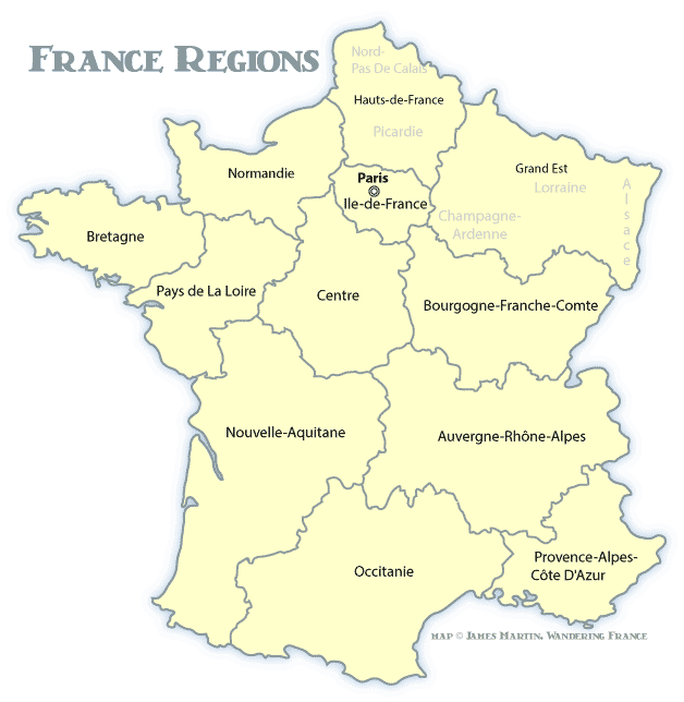
Why the difference? Amalgamation. It’s a fancy word for making big regions out of a few smaller ones so that regional governments can be combined for what is imagined as a “cost savings”. In short, the French parliament passed a law reducing the number of metropolitan regions from 22 to 13 in 2014, which became effective on January 1st, 2016. That’s reflected on our map today.
What you’ll notice on the map is that many of the regions whose names invoked powerful emotions of a special place are gone. Certainly people will use them for a couple of generations before they disappear, so I’ve left a few lightly labeled on the map. Alsace and Lorraine are a couple of those, combined with Champagne-Ardenne and turned in to the adman’s dream label “Grand Est”, the Big East. Don’t confuse it with the Big Easy or a loose confederation of American college football teams.
The map reflects 12 mainland regions; there are actually 13 metropolitan regions, with Corsica standing for both an island and a region.
France also has 5 overseas regions: French Guiana in South America Guadeloupe in the Caribbean (Americas) Martinique in the Caribbean (Americas) Mayotte in the Indian Ocean (Africa) Réunion in the Indian Ocean (Africa)
Since each of these regions contains a single department, the government favors calling them simply departments rather than regions.
The biggest GDP by far is generated in a small region around Paris, the Île-de-France.
So there you have them, the French regions explained.