PAD Conowingo Hydroelectric Project - Exelon Corporation
PAD Conowingo Hydroelectric Project - Exelon Corporation
PAD Conowingo Hydroelectric Project - Exelon Corporation

Create successful ePaper yourself
Turn your PDF publications into a flip-book with our unique Google optimized e-Paper software.
A. Karen Hill, Esq. Telephone 202.347.7500<br />
Vice President Fax 202.347.7501<br />
Federal Regulatory Affairs www.exeloncorp.com<br />
<strong>Exelon</strong> <strong>Corporation</strong><br />
101 Constitution Avenue, NW<br />
Suite 400 East<br />
Washington, DC 20001<br />
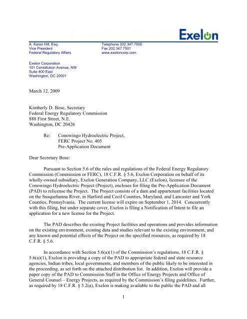
March 12, 2009<br />
Kimberly D. Bose, Secretary<br />
Federal Energy Regulatory Commission<br />
888 First Street, N.E.<br />
Washington, DC 20426<br />
Re: <strong>Conowingo</strong> <strong>Hydroelectric</strong> <strong>Project</strong>,<br />
FERC <strong>Project</strong> No. 405<br />
Pre-Application Document<br />
Dear Secretary Bose:<br />
Pursuant to Section 5.6 of the rules and regulations of the Federal Energy Regulatory<br />
Commission (Commission or FERC), 18 C.F.R. § 5.6, <strong>Exelon</strong> <strong>Corporation</strong> on behalf of its<br />
wholly-owned subsidiary, <strong>Exelon</strong> Generation Company, LLC (<strong>Exelon</strong>), licensee of the<br />
<strong>Conowingo</strong> <strong>Hydroelectric</strong> <strong>Project</strong> (<strong>Project</strong>), encloses for filing the Pre-Application Document<br />
(<strong>PAD</strong>) to relicense the <strong>Project</strong>. The <strong>Project</strong> consists of a dam and appurtenant facilities located<br />
on the Susquehanna River, in Harford and Cecil Counties, Maryland, and Lancaster and York<br />
Counties, Pennsylvania. The current license will expire on September 1, 2014. Concurrently<br />
with this filing, but under separate cover, <strong>Exelon</strong> is filing a Notification of Intent to file an<br />
application for a new license for the <strong>Project</strong>.<br />
The <strong>PAD</strong> describes the existing <strong>Project</strong> facilities and operations and provides information<br />
on the existing environment, existing data and studies relevant to the existing environment, and<br />
any known and potential effects of the <strong>Project</strong> on the specified resources, as required by 18<br />
C.F.R. § 5.6.<br />
In accordance with Section 5.6(a)(1) of the Commission’s regulations, 18 C.F.R. §<br />
5.6(a)(1), <strong>Exelon</strong> is providing a copy of the <strong>PAD</strong> to appropriate federal and state resource<br />
agencies, Indian tribes, local governments, and members of the public likely to be interested in<br />
the proceeding, as set forth on the attached distribution list. In addition, <strong>Exelon</strong> will provide a<br />
paper copy of the <strong>PAD</strong> to Commission Staff in the Office of Energy <strong>Project</strong>s and Office of<br />
General Counsel – Energy <strong>Project</strong>s, as required by the Commission’s filing guidelines. Further,<br />
as required by 18 C.F.R. § 5.2(a), <strong>Exelon</strong> is making available to the public the <strong>PAD</strong> and all<br />
1
materials referenced therein at the Visitor’s Center at Muddy Run Recreation Park in Holtwood,<br />
Pennsylvania, and the Darlington Public Library in Darlington, Maryland, during regular<br />
business hours.<br />
<strong>Exelon</strong> looks forward to working with the Commission, agencies, Indian tribes, local<br />
governments, and members of the public on the relicensing of the <strong>Project</strong>. If you have any<br />
questions regarding the above, please do not hesitate to contact the undersigned. Thank you for<br />
your assistance in this matter.<br />
Respectfully submitted,<br />
Colleen E. Hicks<br />
Manager Regulatory and Licensing, Hydro<br />
<strong>Exelon</strong> Power<br />
300 <strong>Exelon</strong> Way<br />
Kennett Square, PA 19348<br />
Tel: (610) 765-6791<br />
Email: Colleen.hicks@exeloncorp.com<br />
A. Karen Hill<br />
Vice President Federal Regulatory Affairs<br />
<strong>Exelon</strong> <strong>Corporation</strong><br />
101 Constitution Ave.<br />
Suite 400E<br />
Washington, DC 20001<br />
Tel: (202) 347-8092<br />
Email: Karen.Hill@exeloncorp.com<br />
2
Mr. Michael Brownell<br />
Susquehanna River Basin Commission<br />
1721 N. Front Street<br />
Harrisburg, PA 17102-2391<br />
Mr. Larry Miller<br />
US Fish and Wildlife Service<br />
1601 Elmerton Avenue<br />
Harrisburg, PA 17110<br />
Shawn A. Seaman<br />
Maryland Department of Natural Resources<br />
Power Plant Research Program<br />
Tawes State Office Building B-3<br />
580 Taylor Avenue<br />
Annapolis, Maryland 21401<br />
Mr. John McGillen<br />
Maryland Department of the Environment<br />
Industrial Discharge Permits Division<br />
1800 Washington Blvd<br />
Baltimore, MD 21230<br />
Mr. Elder Ghigiarelli<br />
Deputy Administrator<br />
Maryland Department of the Environment<br />
Wetlands and Waterways Program<br />
1800 Washington Blvd<br />
Baltimore, MD 21230<br />
Mr. Kevin Mendik<br />
National Park Service<br />
Boston Support Office<br />
15 State Street<br />
Boston, MA 02109<br />
Mr. James Kardatzke<br />
Bureau of Indian Affairs<br />
U.S. Department of the Interior<br />
545 Mariott Drive, Suite 700<br />
Nashville, TN 37214<br />
<strong>PAD</strong> Distribution List for FERC <strong>Project</strong> No. 405<br />
3<br />
Mr. Jon Kurland<br />
National Marine Fisheries Service<br />
Northeast Regional Office<br />
One Blackburn Drive<br />
Gloucester, MA 01930-2298<br />
Mr. William T. Wisniewski<br />
Deputy Regional Administrator<br />
US Environmental Protection Agency-<br />
Region III<br />
1650 Arch Street<br />
Philadelphia, PA 19103-2029<br />
Mr. Larry Williamson<br />
Pennsylvania Department of Conservation<br />
and Natural Resources<br />
PO Box 1554<br />
Harrisburg, PA 17105-8767<br />
Mr. James Spontak<br />
Pennsylvania Department of Environmental<br />
Protection<br />
909 Elmerton Avenue<br />
Harrisburg, PA 17110-8200<br />
Mr. Andrew Shiels<br />
Pennsylvania Fish and Boat Commission<br />
1601 Elmerton Avenue<br />
PO Box 67000<br />
Harrisburg, PA 17106-7000<br />
Mr. James Leigey<br />
Pennsylvania Game Commission<br />
Bureau of Land Management<br />
2001 Elmerton Ave<br />
Harrisburg, PA 17106-9762<br />
Mr. Wayne Spilove<br />
Pennsylvania Historical & Museum<br />
Commission<br />
300 North Street<br />
Harrisburg, PA 17120-0093
J. Rodney Little<br />
Director and SHPO<br />
Maryland Historical Trust<br />
100 Community Place<br />
Crownsville, Maryland 21032<br />
Alliance for Chesapeake Bay<br />
6600 York Rd.<br />
Suite 100<br />
Baltimore, MD 21212<br />
Atlantic State Marine Fisheries Commission<br />
1444 Eye St. NW<br />
6th Floor<br />
Washington, DC 20005<br />
Cecil County Parks & Recreation<br />
200 Chesapeake Blvd.<br />
Suite 1200<br />
Elkton, MD 21921<br />
Chesapeake Bay Foundation<br />
6 Herndon Ave.<br />
Annapolis, MD 21403<br />
Harford County Parks & Recreation<br />
702 N. Tollgate Rd.<br />
Bel Air, MD 21014<br />
Lancaster County Parks & Recreation<br />
1050 Rockford Rd.<br />
Lancaster, PA 17602<br />
Lower Susquehanna Riverkeeper<br />
324 W. Market St.<br />
York, PA 17401<br />
York County Parks & Recreation<br />
400 Mundis Race Rd.<br />
York, PA 17406<br />
York County<br />
100 W Market Street<br />
York, PA, 17401<br />
4<br />
Lancaster County<br />
50 North Duke Street<br />
Lancaster, PA. 17608<br />
Cecil County<br />
107 North Street<br />
Elkton, MD 21921<br />
Harford County<br />
212 South Bond Street<br />
Bel Air, MD 21014<br />
Lower Chanceford Township<br />
4120 Delta Road<br />
Airville, PA 17302<br />
Peach Bottom Township<br />
545 Broad Street, Extended<br />
Delta, PA 17314<br />
Martic Township<br />
370 Steinman Farm Road<br />
Pequea, PA 17565<br />
Drumore Township<br />
PO Box 38<br />
Drumore, PA 17518<br />
Fulton Township<br />
777 Nottingham Road<br />
Peach Bottom, PA 17563<br />
City of Havre de Grace<br />
711 Pennington Avenue<br />
Havre de Grace, MD 21078<br />
City of Port Deposit<br />
64 S. Main Street<br />
Port Deposit, MD 21904<br />
Borough of Oxford<br />
401 Market Street<br />
Oxford, PA 19363
Town of Bel Air<br />
39 Hickory Avenue<br />
Bel Air, MD 21014<br />
City of Aberdeen<br />
60 North Parke Street<br />
Aberdeen, MD 21001<br />
5<br />
Delaware Nation<br />
P.O. Box 825<br />
Anadarko, OK 73005
PRE-APPLICATION DOCUMENT<br />
FOR THE<br />
CONOWINGO HYDROELECTRIC PROJECT<br />
FERC PROJECT NUMBER 405<br />
EXELON GENERATION COMPANY, LLC<br />
March 2009
<strong>Conowingo</strong> <strong>Hydroelectric</strong> <strong>Project</strong> Pre-Application Document<br />
FERC No. 405 March 2009<br />
TABLE OF CONTENTS<br />
LIST OF TABLES ..................................................................................................................................... vi<br />
1.0 INTRODUCTION ...................................................................................................................... 1-1<br />
2.0 PROCESS PLAN AND SCHEDULE ........................................................................................ 2-1<br />
3.0 PROJECT LOCATION, FACILITIES, AND OPERATION ................................................ 3-1<br />
3.1 <strong>Project</strong> Location ..................................................................................................................... 3-1<br />
3.2 <strong>Project</strong> Facilities ..................................................................................................................... 3-1<br />
3.3 <strong>Project</strong> Location and Lands .................................................................................................... 3-5<br />
3.4 Current <strong>Project</strong> Operation ...................................................................................................... 3-5<br />
3.5 Reservoir Storage ................................................................................................................... 3-7<br />
3.6 Other <strong>Project</strong> Information ...................................................................................................... 3-8<br />
3.6.1 Current License Requirements ......................................................................................... 3-8<br />
3.6.2 Compliance History ....................................................................................................... 3-10<br />
3.6.3 Current Net Investment .................................................................................................. 3-11<br />
3.6.4 Proposed Operation ........................................................................................................ 3-11<br />
3.6.5 Summary of <strong>Project</strong> Generation ..................................................................................... 3-11<br />
4.0 DESCRIPTION OF EXISTING ENVIRONMENT AND RESOURCE IMPACTS (18<br />
C.F.R. §5.6 (d)(3) ...................................................................................................................................... 4-1<br />
4.1 General Description of the River Basin (18 C.F.R. §5.6 (d)(3)(xiii) ..................................... 4-1<br />
4.1.1 Major Land Uses .............................................................................................................. 4-1<br />
4.1.2 Major Water Uses ............................................................................................................ 4-1<br />
4.1.3 Basin Dams and other Energy Producers ......................................................................... 4-2<br />
4.1.4 Tributary Streams ............................................................................................................ 4-3<br />
4.2 Geology and Soils (18 C.F.R. §5.6(d)(3)(ii) .......................................................................... 4-3<br />
4.2.1 Topography ...................................................................................................................... 4-3<br />
4.2.2 Geology ............................................................................................................................ 4-4<br />
4.2.2.1 Bedrock Geology ....................................................................................................... 4-4<br />
4.2.2.2 Surficial Geology ...................................................................................................... 4-5<br />
4.2.3 Soils ................................................................................................................................. 4-5<br />
4.2.3.1 Pennsylvania .............................................................................................................. 4-6<br />
4.2.3.2 Maryland ................................................................................................................... 4-6<br />
4.2.4 Reservoir Shoreline .......................................................................................................... 4-7<br />
i
<strong>Conowingo</strong> <strong>Hydroelectric</strong> <strong>Project</strong> Pre-Application Document<br />
FERC No. 405 March 2009<br />
4.2.4.1 Field studies ............................................................................................................... 4-7<br />
4.2.4.2 Shoreline Types ......................................................................................................... 4-7<br />
4.2.4.3 Erosion Features ........................................................................................................ 4-7<br />
4.2.4.4 Shoreline Erosion Inventory ...................................................................................... 4-8<br />
4.2.4.5 Depositional Features ................................................................................................ 4-9<br />
4.2.4.6 Potential <strong>Project</strong>-Related Causes of Shoreline Erosion ............................................. 4-9<br />
4.3 Water Resources (18 C.F.R. §5.6 (d)(3)(iii) ......................................................................... 4-10<br />
4.3.1 Water Quantity ............................................................................................................... 4-10<br />
4.3.1.1 Hydrology and Streamflow ..................................................................................... 4-10<br />
4.3.1.2 Major Water Withdrawals and Use ......................................................................... 4-11<br />
4.3.1.3 Surface Water Discharges ....................................................................................... 4-13<br />
4.3.2 Water Quality ................................................................................................................. 4-14<br />
4.3.2.1 Water Quality Standards and Classifications .......................................................... 4-14<br />
4.3.2.2 Sediment and Nutrient Loading .............................................................................. 4-17<br />
4.3.2.3 Existing Water Quality Studies ............................................................................... 4-19<br />
4.3.2.4 Existing Water Chemistry ....................................................................................... 4-23<br />
4.3.2.4.1 <strong>Conowingo</strong> Pond ......................................................................................................... 4-23<br />
4.3.2.4.2 <strong>Conowingo</strong> Tailrace ..................................................................................................... 4-25<br />
4.4 Fish and Aquatic Resources (18 C.F.R. §5.6 (d)(3)(iv) ....................................................... 4-27<br />
4.4.1 Resident Fish Species .................................................................................................... 4-27<br />
4.4.1.1 <strong>Conowingo</strong> Pond ..................................................................................................... 4-28<br />
4.4.1.2 Susquehanna River below <strong>Conowingo</strong> Dam ........................................................... 4-31<br />
4.4.2 Migratory fish species .................................................................................................... 4-32<br />
4.4.2.1 Anadromous Fish Species below <strong>Conowingo</strong> Dam ................................................ 4-33<br />
4.4.2.2 Anadromous Fish Species in <strong>Conowingo</strong> Pond ...................................................... 4-45<br />
4.4.2.3 Catadromous Fish Species ....................................................................................... 4-48<br />
4.4.2.4 Commercial Fishing below <strong>Conowingo</strong> Dam ......................................................... 4-51<br />
4.4.3 Recreational Fishery ...................................................................................................... 4-52<br />
4.4.3.1 <strong>Conowingo</strong> Pond ..................................................................................................... 4-52<br />
4.4.3.2 Susquehanna River below <strong>Conowingo</strong> Dam ........................................................... 4-53<br />
4.4.4 Benthic Macroinvertebrates ........................................................................................... 4-58<br />
4.4.4.1 Lower Susquehanna River Basin ............................................................................ 4-59<br />
4.4.4.2 <strong>Conowingo</strong> Pond ..................................................................................................... 4-60<br />
ii
<strong>Conowingo</strong> <strong>Hydroelectric</strong> <strong>Project</strong> Pre-Application Document<br />
FERC No. 405 March 2009<br />
4.4.4.3 <strong>Conowingo</strong> Dam Tailrace and Points Downstream ................................................ 4-61<br />
4.4.4.4 Nuisance Macroinvertebrate Species ...................................................................... 4-62<br />
4.4.5 Phytoplankton and Zooplankton .................................................................................... 4-63<br />
4.4.6 Aquatic Habitat .............................................................................................................. 4-64<br />
4.4.6.1 Susquehanna River below <strong>Conowingo</strong> Dam ........................................................... 4-64<br />
4.5 Terrestrial Wildlife and Botanical Resources (18 C.F.R. §5.6 (d)(3)(v)) ............................. 4-66<br />
4.5.1 Upland Botanical Resources .......................................................................................... 4-66<br />
4.5.2 Terrestrial Wildlife ........................................................................................................ 4-68<br />
4.5.2.1 Mammals ................................................................................................................. 4-69<br />
4.5.2.2 Birds ........................................................................................................................ 4-69<br />
4.6 Wetlands, Riparian, and Littoral Habitat (18 C.F.R. §5.6 (d)(3)(vi))................................... 4-69<br />
4.6.1 Wetland Habitat ............................................................................................................. 4-70<br />
4.6.1.1 <strong>Conowingo</strong> Pond ..................................................................................................... 4-70<br />
4.6.1.2 Below <strong>Conowingo</strong> Dam .......................................................................................... 4-72<br />
4.6.2 Littoral Zone Habitat ..................................................................................................... 4-72<br />
4.6.2.1 <strong>Conowingo</strong> Pond ..................................................................................................... 4-72<br />
4.6.2.2 Below <strong>Conowingo</strong> Dam .......................................................................................... 4-75<br />
4.6.3 Riparian Zone Habitat .................................................................................................... 4-75<br />
4.6.4 Wetland, Littoral, and Riparian Vegetation ................................................................... 4-76<br />
4.6.5 Wetland, Littoral, and Riparian Wildlife ....................................................................... 4-76<br />
4.7 Critical Habitat and Threatened and Endangered Species (18 C.F.R. §5.6(d)(3)(vii)) ........ 4-77<br />
4.7.1 Natural Areas ................................................................................................................. 4-77<br />
4.7.2 T & E Species (Federal and State Listed Species) ......................................................... 4-83<br />
4.7.2.1 Birds ........................................................................................................................ 4-84<br />
4.7.2.2 Reptiles and Amphibians ......................................................................................... 4-86<br />
4.7.2.3 Fish 4-87<br />
4.7.2.4 Plants ....................................................................................................................... 4-91<br />
4.7.3 Non-Listed Rare Species ............................................................................................... 4-98<br />
4.7.3.1 Birds ........................................................................................................................ 4-98<br />
4.7.3.2 Fish 4-99<br />
4.7.3.3 Invertebrates .......................................................................................................... 4-100<br />
4.7.3.4 Plants ..................................................................................................................... 4-100<br />
4.8 Recreation and Land Use (18 C.F.R. §5.6 (d)(3)(viii) ....................................................... 4-104<br />
iii
<strong>Conowingo</strong> <strong>Hydroelectric</strong> <strong>Project</strong> Pre-Application Document<br />
FERC No. 405 March 2009<br />
4.8.1 Existing Recreational Facilities and Opportunities ...................................................... 4-104<br />
4.8.1.1 <strong>Conowingo</strong> Pond Recreation Facilities ................................................................. 4-105<br />
4.8.1.2 Downstream Recreation Facilities ......................................................................... 4-107<br />
4.8.1.3 State Parks ............................................................................................................. 4-108<br />
4.8.1.4 Other Recreational Facilities ................................................................................. 4-109<br />
4.8.2 Recreational Use .......................................................................................................... 4-109<br />
4.8.3 Land Use ...................................................................................................................... 4-110<br />
4.8.3.1 Currently Designated Natural Areas ..................................................................... 4-111<br />
4.8.3.2 <strong>Project</strong> Boundary ................................................................................................... 4-112<br />
4.8.3.3 Shoreline Management .......................................................................................... 4-112<br />
4.9 Aesthetic Resources (18 C.F.R. §5.6 (d)(3)(ix) .................................................................. 4-112<br />
4.9.1 Landscape Description ................................................................................................. 4-112<br />
4.9.2 Scenic Byways and Viewscapes .................................................................................. 4-113<br />
4.10 Cultural Resources (18 C.F.R. §5.6 (d)(3)(x) ..................................................................... 4-114<br />
4.10.1 Prehistoric Context ...................................................................................................... 4-115<br />
4.10.2 Historic Context ........................................................................................................... 4-117<br />
4.10.3 Archeology ................................................................................................................... 4-122<br />
4.10.4 Historic Structures ....................................................................................................... 4-123<br />
4.11 Socio-Economic Resources (18 C.F.R. §5.6 (d)(3)(xi) ...................................................... 4-123<br />
4.11.1 Population Patterns ...................................................................................................... 4-123<br />
4.11.2 Economic Patterns ....................................................................................................... 4-123<br />
4.11.3 Transportation Infrastructure and Access .................................................................... 4-124<br />
4.12 Tribal Resources (18 C.F.R. §5.6(d)(3)(xii) ....................................................................... 4-124<br />
5.0 PRELIMINARY ISSUES AND STUDIES LIST (18 C.F.R. §5.6(d)(4) ................................. 5-1<br />
5.1 Issues Pertaining to the Identified Resources ......................................................................... 5-1<br />
5.2 Potential Studies or Information Gathering ............................................................................ 5-2<br />
5.3 Relevant Comprehensive Waterway Plans ............................................................................. 5-4<br />
5.4 Relevant Resource Management Plan .................................................................................... 5-7<br />
iv
<strong>Conowingo</strong> <strong>Hydroelectric</strong> <strong>Project</strong> Pre-Application Document<br />
FERC No. 405 March 2009<br />
6.0 LITERATURE AND INFORMATION SOURCES CITED IN THE DESCRIPTIONS AND<br />
SUMMARIES OF EXISTING RESOURCE DATA (18 C.F.R. §5.6(c)(2) ......................................... 6-1<br />
7.0 APPENDIX A – SUMMARY OF CONTACTS AND CORRESPONDENCE LETTER<br />
MADE IN PREPARING THE <strong>PAD</strong> (18 C.F.R. §5.6(d)(5) ................................................................... 7-1<br />
8.0 APPENDIX B – PRE-APPLICATION DOCUMENT CONTENT CROSS REFERENCE<br />
TABLE ...................................................................................................................................................... 8-1<br />
9.0 APPENDIX C – AGENT FOR THE APPLICANT 18 C.F.R. 5.6(d)(2)(i) ............................ 9-1<br />
10.0 APPENDIX D – CURRENT LICENSE AND AMENDMENTS .......................................... 10-1<br />
v
<strong>Conowingo</strong> <strong>Hydroelectric</strong> <strong>Project</strong> Pre-Application Document<br />
FERC No. 405 March 2009<br />
LIST OF TABLES<br />
(Following Sections)<br />
Table 2.0-1 ................................................................................................................................................ 2-3<br />
Process Plan and Schedule .................................................................................................................. 2-3<br />
Table 3.2-1 .............................................................................................................................................. 3-12<br />
Summary of Turbine Characteristics at the <strong>Conowingo</strong> <strong>Project</strong> ....................................................... 3-12<br />
Table 3.2-2 .............................................................................................................................................. 3-13<br />
Summary of Electric Generator Characteristics at the <strong>Conowingo</strong> <strong>Project</strong> ...................................... 3-13<br />
Table 3.6.5-1 ........................................................................................................................................... 3-14<br />
Summary of Net <strong>Conowingo</strong> <strong>Project</strong> Generation (MWH) for 1996-2008 ........................................ 3-14<br />
Table 3.6.5-2 ........................................................................................................................................... 3-15<br />
Summary of Net <strong>Conowingo</strong> <strong>Project</strong> Average Monthly and Annual Outflows (cfs) for<br />
1996-2008 as Measured at the Susquehanna River at <strong>Conowingo</strong>, Maryland (No. 01578310) ........ 3-15<br />
Table 4.1-1 ............................................................................................................................................ 4-125<br />
Characteristics of the Susquehanna River Subbasins ...................................................................... 4-125<br />
Table 4.1.3-1 ......................................................................................................................................... 4-126<br />
Hydropower in the Lower Susquehanna River Subbasin ................................................................ 4-126<br />
Table 4.1.4-1 ......................................................................................................................................... 4-127<br />
Major Tributaries to the Lower Susquehanna River ....................................................................... 4-127<br />
Table 4.2.2.1-1 ...................................................................................................................................... 4-128<br />
Bedrock Geologic Units of the <strong>Project</strong> Area in Pennsylvania ......................................................... 4-128<br />
Table 4.2.2.1-2 ...................................................................................................................................... 4-129<br />
Bedrock Geologic Units of the <strong>Project</strong> Area in Maryland .............................................................. 4-129<br />
Table 4.2.2.2-1 ...................................................................................................................................... 4-130<br />
Surficial Geologic Units of the <strong>Project</strong> Area in Pennsylvania ........................................................ 4-130<br />
Table 4.2.3.1-1 ...................................................................................................................................... 4-131<br />
Soil Units of <strong>Project</strong> Area in Pennsylvania ..................................................................................... 4-131<br />
Table 4.2.3.2-1 ...................................................................................................................................... 4-133<br />
Soil Units of <strong>Project</strong> Area in Maryland ........................................................................................... 4-133<br />
Table 4.3.1.1-1 ...................................................................................................................................... 4-134<br />
Corps of Engineers Storage Reservoirs within the Susquehanna River Basin ................................ 4-134<br />
vi
<strong>Conowingo</strong> <strong>Hydroelectric</strong> <strong>Project</strong> Pre-Application Document<br />
FERC No. 405 March 2009<br />
Table 4.3.1.1-2 ...................................................................................................................................... 4-135<br />
Minimum, Median, Mean, and Maximum Flow by Month at Marietta USGS Gage, 1967-2008 .. 4-135<br />
Table 4.3.1.1-3 ...................................................................................................................................... 4-136<br />
Minimum, Median, Mean, and Maximum Flow by Month at <strong>Conowingo</strong> USGS Gage,<br />
1967-2008 ........................................................................................................................................ 4-136<br />
Table 4.3.1.3-1 ...................................................................................................................................... 4-137<br />
Summary of NPDES Dischargers along the <strong>Conowingo</strong> Pond Segment of the<br />
Susquehanna River .......................................................................................................................... 4-137<br />
Table 4.3.2.1-1 ...................................................................................................................................... 4-138<br />
Summary of Pennsylvania’s Protected Water Use Categories ........................................................ 4-138<br />
Table 4.3.2.1-2 ...................................................................................................................................... 4-140<br />
Pennsylvania’s Maximum Water Temperature ............................................................................... 4-140<br />
Criteria Specified for Warm Water Fishes ...................................................................................... 4-140<br />
Table 4.3.2.1-3 ...................................................................................................................................... 4-141<br />
Summary of Maryland’s Designated Use Categories ...................................................................... 4-141<br />
Table 4.3.2.1-4 ...................................................................................................................................... 4-142<br />
Summary of “2006 List of Impaired Surface Waters [303(d) List] and Integrated Assessment of<br />
Water Quality in Maryland” Listings for the Mainstem of the Susquehanna River within the<br />
<strong>Conowingo</strong> Dam Basin and Lower Susquehanna River Basin ....................................................... 4-142<br />
Table 4.3.2.2-1 ...................................................................................................................................... 4-144<br />
Annual Sediment and Nutrient Loadings Below <strong>Conowingo</strong> Dam (1985-2004) ............................ 4-144<br />
Table 4.3.2.4-1 ...................................................................................................................................... 4-145<br />
Comparison Of Frequency Distribution Of Hourly DO Measurements Monitored in the Tailrace<br />
(Station 643), <strong>Conowingo</strong> Hydro Station, June-September 1982-1988 .......................................... 4-145<br />
Table 4.3.2.4-2 ...................................................................................................................................... 4-147<br />
Select Water Quality Parameters Collected by USGS for the Susquehanna River at the<br />
<strong>Conowingo</strong> Dam, January 1978-June 2000 ..................................................................................... 4-147<br />
Table 4.4.1-1 ......................................................................................................................................... 4-150<br />
Fish Species within the <strong>Conowingo</strong> <strong>Project</strong> Waters ........................................................................ 4-150<br />
Table 4.4.1.1-1 ...................................................................................................................................... 4-155<br />
Summary Of Annual Fish Catches In <strong>Conowingo</strong> Pond Relative To PBAPS, 1996-1999. Taxa Listed<br />
Comprised ≥ 5% of the Annual Total Of Fish Collected By All Gears In At Least One Year. ...... 4-155<br />
Table 4.4.1.2-1 ...................................................................................................................................... 4-156<br />
Electrofishing Catches in the Susquehanna River Below <strong>Conowingo</strong> Dam,<br />
vii
<strong>Conowingo</strong> <strong>Hydroelectric</strong> <strong>Project</strong> Pre-Application Document<br />
FERC No. 405 March 2009<br />
January-November 1983. ................................................................................................................ 4-156<br />
Table 4.4.1.2-2 ...................................................................................................................................... 4-157<br />
Gill Net Catches in the Susquehanna River Below <strong>Conowingo</strong> Dam, July-November 1983. ........ 4-157<br />
Table 4.4.1.2-3 ...................................................................................................................................... 4-158<br />
Comparison of Annual Catch of Common Resident Species at <strong>Conowingo</strong> Dam West Fish<br />
Lift, 1991-2008 ................................................................................................................................ 4-158<br />
Table 4.4.1.2-4 ...................................................................................................................................... 4-160<br />
Comparison of Annual Catch of Common Resident Species at <strong>Conowingo</strong> Dam East<br />
Fish Lift, 1991-2008. ....................................................................................................................... 4-160<br />
Table 4.4.2-1 ......................................................................................................................................... 4-161<br />
Annual Count of Migratory Fishes at the <strong>Conowingo</strong> Dam West Fish Lift (1972-2008) ............... 4-161<br />
Table 4.4.2-2 ......................................................................................................................................... 4-163<br />
Annual Count of Migratory Fishes at the <strong>Conowingo</strong> Dam East Fish Lift (1991-2008) ................ 4-163<br />
Table 4.4.2.1-1 ...................................................................................................................................... 4-164<br />
Juvenile Abundance Index for American Shad Collected By Haul Seine in the<br />
Susquehanna River at Marietta, Columbia, and Wrightsville, 1990-2005. ..................................... 4-164<br />
Table 4.4.2.1-2 ...................................................................................................................................... 4-165<br />
Juvenile Abundance Index for American Shad Collected By Lift Net in the Forebay of<br />
Holtwood <strong>Hydroelectric</strong> Station, Susquehanna River, 1985-2005 .................................................. 4-165<br />
Table 4.4.2.2-1 ...................................................................................................................................... 4-166<br />
Estimated Spawning Condition of Adult American Shad, Natural River Flows, and Water<br />
Temperature during the Various Radio Telemetry Studies in <strong>Conowingo</strong> Pond, 1987-2001 ......... 4-166<br />
Table 4.4.3.2-1. ..................................................................................................................................... 4-168<br />
Estimated Annual Fishing Pressure in the Lower Susquehanna River Below <strong>Conowingo</strong> Dam,<br />
Maryland. ........................................................................................................................................ 4-168<br />
Table 4.4.3.2-2 ...................................................................................................................................... 4-169<br />
Annual Fish Harvest Composition (%) and Mean Annual Harvest (Number) by<br />
Recreational Anglers in the Susquehanna River Below <strong>Conowingo</strong> Dam, 1981-1987. ................. 4-169<br />
Table 4.4.4.1-1 ...................................................................................................................................... 4-170<br />
Benthic Macroinvertebrates Known to Occur in the Vicinity of the <strong>Project</strong> Area .......................... 4-170<br />
Table 4.4.5-1 ......................................................................................................................................... 4-178<br />
Algal Species Identified in <strong>Conowingo</strong> Pond.................................................................................. 4-178<br />
viii
<strong>Conowingo</strong> <strong>Hydroelectric</strong> <strong>Project</strong> Pre-Application Document<br />
FERC No. 405 March 2009<br />
Table 4.4.5-2 ......................................................................................................................................... 4-179<br />
Dominant Zooplankton Species Identified in <strong>Conowingo</strong> Pond ..................................................... 4-179<br />
Table 4.4.6-1 ......................................................................................................................................... 4-180<br />
Proportional Habitat Composition of Non-Tidal River below <strong>Conowingo</strong> Dam ............................ 4-180<br />
Table 4.5.1-1 ......................................................................................................................................... 4-181<br />
Vegetation Species Near Northern <strong>Project</strong> Area ............................................................................. 4-181<br />
Table 4.5.2.1-1 ...................................................................................................................................... 4-190<br />
Mammals Near Northern <strong>Project</strong> Area ............................................................................................ 4-190<br />
Table 4.5.2.2-1 ...................................................................................................................................... 4-192<br />
Birds Observed Along Susquehanna River Near <strong>Conowingo</strong> Dam (Glen Cove Marina to<br />
Deer Creek) ..................................................................................................................................... 4-192<br />
Table 4.6.2.1-1 ...................................................................................................................................... 4-201<br />
Mt. Johnson Island – Littoral Zone Substrate.................................................................................. 4-201<br />
Table 4.6.2.1-2 ...................................................................................................................................... 4-202<br />
Peters Creek-Littoral Zone Substrate .............................................................................................. 4-202<br />
Table 4.6.2.1-3 ...................................................................................................................................... 4-203<br />
Fishing Creek – Littoral Zone Substrate ......................................................................................... 4-203<br />
Table 4.6.4-1 ......................................................................................................................................... 4-204<br />
Riverbed Wetland Near Norman Wood Bridge Vegetation ............................................................ 4-204<br />
Table 4.6.4-1a ....................................................................................................................................... 4-205<br />
Emergent Wetland Plants of <strong>Conowingo</strong> Pond ............................................................................... 4-205<br />
Table 4.6.4-2 ......................................................................................................................................... 4-208<br />
Shoreline Margin Wetland Near Norman Wood Bridge Vegetation ............................................... 4-208<br />
Table 4.6.4-3 ......................................................................................................................................... 4-209<br />
Submerged Aquatic Vegetation in <strong>Conowingo</strong> Pond ...................................................................... 4-209<br />
Table 4.6.4-4 ......................................................................................................................................... 4-210<br />
Mt. Johnson Island Riparian Vegetation ......................................................................................... 4-210<br />
Table 4.6.4-5 ......................................................................................................................................... 4-212<br />
<strong>Conowingo</strong> Pond Near Peters Creek Riparian Vegetation .............................................................. 4-212<br />
Table 4.6.4-6 ......................................................................................................................................... 4-213<br />
<strong>Conowingo</strong> Pond Near Fishing Creek Riparian Vegetation ............................................................ 4-213<br />
Table 4.6.5-1 ......................................................................................................................................... 4-214<br />
Reptiles and Amphibians Near Northern <strong>Project</strong> Area ................................................................... 4-214<br />
ix
<strong>Conowingo</strong> <strong>Hydroelectric</strong> <strong>Project</strong> Pre-Application Document<br />
FERC No. 405 March 2009<br />
Table 4.7.2.1-1 ...................................................................................................................................... 4-215<br />
Rare, Threatened, and Endangered Bird Species Potentially in <strong>Conowingo</strong> <strong>Project</strong> Area ............. 4-215<br />
Table 4.7.2.2-1 ...................................................................................................................................... 4-216<br />
Rare, Threatened, and Endangered Reptile and Amphibian Species Potentially in<br />
<strong>Conowingo</strong> <strong>Project</strong> Area ................................................................................................................. 4-216<br />
Table 4.7.2.3-1 ...................................................................................................................................... 4-217<br />
Rare, Threatened, and Endangered Fish and Invertebrate Species Potentially in<br />
<strong>Conowingo</strong> <strong>Project</strong> Area ................................................................................................................. 4-217<br />
Table 4.7.2.4-1 ...................................................................................................................................... 4-218<br />
Rare, Threatened, and Endangered Plant Species Potentially in <strong>Conowingo</strong> <strong>Project</strong> Area ............ 4-218<br />
Table 4.11.1-1 ....................................................................................................................................... 4-220<br />
Population and Housing Data in Cecil, Harford, York and Lancaster Counties ............................. 4-220<br />
Table 4.11.1-2 ....................................................................................................................................... 4-221<br />
Population Trends within Cecil, Harford, York and Lancaster Counties ........................................ 4-221<br />
Table 4.11.1-3 ....................................................................................................................................... 4-222<br />
Major Population Centers Near the <strong>Conowingo</strong> <strong>Project</strong> ................................................................. 4-222<br />
Table 4.11.2-1 ....................................................................................................................................... 4-223<br />
Income Distribution within Cecil, Harford, York, and Lancaster Counties .................................... 4-223<br />
Table 4.11.2-2 ....................................................................................................................................... 4-224<br />
Occupation Distribution Within Cecil, Harford, York, And Lancaster Counties ........................... 4-224<br />
x
<strong>Conowingo</strong> <strong>Hydroelectric</strong> <strong>Project</strong> Pre-Application Document<br />
FERC No. 405 March 2009<br />
LIST OF FIGURES<br />
Figure 3.1-1 ............................................................................................................................................. 3-16<br />
<strong>Conowingo</strong> <strong>Hydroelectric</strong> <strong>Project</strong> ..................................................................................................... 3-16<br />
Figure 3.1-2 ............................................................................................................................................. 3-17<br />
<strong>Conowingo</strong> <strong>Hydroelectric</strong> <strong>Project</strong> Location Map .............................................................................. 3-17<br />
Figure 3.2-1 ............................................................................................................................................. 3-18<br />
<strong>Conowingo</strong> Dam Spillway Rating Curve .......................................................................................... 3-18<br />
Figure 3.2-2 ............................................................................................................................................. 3-19<br />
<strong>Conowingo</strong> Dam Tailwater Rating Curve ......................................................................................... 3-19<br />
Figure 4.1-1 ........................................................................................................................................... 4-225<br />
Lower Susquehanna River Subbasin ............................................................................................... 4-225<br />
Figure 4.1.2-1 ........................................................................................................................................ 4-226<br />
Lower Susquehanna River Subbasin ............................................................................................... 4-226<br />
Figure 4.1.3-1 ........................................................................................................................................ 4-227<br />
Dams in the Lower Susquehanna .................................................................................................... 4-227<br />
Figure 4.1.4-1 ........................................................................................................................................ 4-228<br />
Major Tributaries to the Susquehanna River in the Lower Susquehanna River Subbasin .............. 4-228<br />
Figure 4.2.2.1-1 ..................................................................................................................................... 4-229<br />
Bedrock Geology <strong>Conowingo</strong> <strong>Hydroelectric</strong> <strong>Project</strong> ...................................................................... 4-229<br />
Figure 4.2.3-1 ........................................................................................................................................ 4-230<br />
Soils Within 2000 Feet of <strong>Project</strong> Boundary ................................................................................... 4-230<br />
(Maryland) ....................................................................................................................................... 4-230<br />
Figure 4.2.3-2 ........................................................................................................................................ 4-231<br />
Soils Within 2000 Feet of <strong>Project</strong> Boundary Extent 1 .................................................................... 4-231<br />
(Pennsylvania) ................................................................................................................................. 4-231<br />
Figure 4.2.3-3 ........................................................................................................................................ 4-232<br />
Soils Within 2000 Feet of <strong>Project</strong> Boundary Extent 2 .................................................................... 4-232<br />
(Pennsylvania) ................................................................................................................................. 4-232<br />
Figure 4.2.4.4-1a ................................................................................................................................... 4-233<br />
Shoreline Erosion Study Extent 1 .................................................................................................... 4-233<br />
Figure 4.2.4.4-1b ................................................................................................................................... 4-234<br />
Shoreline Erosion Study Extent 2 .................................................................................................... 4-234<br />
xi
<strong>Conowingo</strong> <strong>Hydroelectric</strong> <strong>Project</strong> Pre-Application Document<br />
FERC No. 405 March 2009<br />
Figure 4.2.4.4-1c ................................................................................................................................... 4-235<br />
Shoreline Erosion Study Extent 3 .................................................................................................... 4-235<br />
Figure 4.2.4.4-1d ................................................................................................................................... 4-236<br />
Shoreline Erosion Study Extent 4 .................................................................................................... 4-236<br />
Figure 4.2.4.4-1e ................................................................................................................................... 4-237<br />
Shoreline Erosion Study Extent 5 .................................................................................................... 4-237<br />
Figure 4.2.4.4-1f .................................................................................................................................... 4-238<br />
Shoreline Erosion Study Extent 6 .................................................................................................... 4-238<br />
Figure 4.3.1.1-1 ..................................................................................................................................... 4-239<br />
Susquehanna River at Marietta, PA USGS Gage, January, February, March, and April<br />
Flow Duration Curves, Period of Record: 1967-2008 ..................................................................... 4-239<br />
Figure 4.3.1.1-2 ..................................................................................................................................... 4-240<br />
Susquehanna River at Marietta, PA USGS Gage, May, June, July, and August Flow<br />
Duration Curves, Period of Record: 1967-2008 .............................................................................. 4-240<br />
Figure 4.3.1.1-3 ..................................................................................................................................... 4-241<br />
Susquehanna River at Marietta, PA USGS Gage, September, October, November, and<br />
December Flow Duration Curves, Period of Record: 1967-2008 ................................................... 4-241<br />
Figure 4.3.1.1-4 ..................................................................................................................................... 4-242<br />
Susquehanna River at Marietta, PA USGS Gage, Annual Flow Duration Curve,<br />
Period of Record: 1967-2008 .......................................................................................................... 4-242<br />
Figure 4.3.1.1-5 ..................................................................................................................................... 4-243<br />
Susquehanna River at <strong>Conowingo</strong>, MD USGS Gage, January, February, March, and<br />
April Flow Duration Curves, Period of Record: 1967-2008 ........................................................... 4-243<br />
Figure 4.3.1.1-6 ..................................................................................................................................... 4-244<br />
Susquehanna River at <strong>Conowingo</strong>, MD USGS Gage, May, June, July, and August Flow<br />
Duration Curves, Period of Record: 1967-2008 .............................................................................. 4-244<br />
Figure 4.3.1.1-7 ..................................................................................................................................... 4-245<br />
Susquehanna River at <strong>Conowingo</strong>, MD USGS Gage, September, October, November, and<br />
December Flow Duration Curves, Period of Record: 1967-2008 ................................................... 4-245<br />
Figure 4.3.1.1-8 ..................................................................................................................................... 4-246<br />
Susquehanna River at <strong>Conowingo</strong>, MD USGS Gage, Annual Flow Duration Curves,<br />
Period of Record: 1967-2008 .......................................................................................................... 4-246<br />
xii
<strong>Conowingo</strong> <strong>Hydroelectric</strong> <strong>Project</strong> Pre-Application Document<br />
FERC No. 405 March 2009<br />
Figure 4.3.1.3-1 ..................................................................................................................................... 4-247<br />
Location of NPDES Discharge Facilities within the <strong>Conowingo</strong> Pond Segment of the<br />
Susquehanna River .......................................................................................................................... 4-247<br />
Figure 4.3.2.1-1 ..................................................................................................................................... 4-248<br />
Location of Chesapeake Bay and Tidal Tributary Water Quality Segments within the Lower<br />
Susquehanna River. ......................................................................................................................... 4-248<br />
Figure 4.3.2.2-1a ................................................................................................................................... 4-249<br />
Susquehanna River Annual Loads – Total Nitrogen ....................................................................... 4-249<br />
Figure 4.3.2.2-1b ................................................................................................................................... 4-250<br />
Susquehanna River Annual Loads – Total Phosphorus ................................................................... 4-250<br />
Figure 4.3.2.2-1c ................................................................................................................................... 4-251<br />
Susquehanna River Annual Loads – Sediment................................................................................ 4-251<br />
Figure 4.3.2.3-1 ..................................................................................................................................... 4-252<br />
Water Quality Stations Sampled in <strong>Conowingo</strong> Pond Relative to Peach Bottom Atomic Power<br />
Station, 1970-1987. Locations With Asterisks (*) Sampled in 1981-1987. ................................... 4-252<br />
Figure 4.3.2.3-2 ..................................................................................................................................... 4-253<br />
Primary Locations Sampled for Dissolved Oxygen (DO) and Water Temperature Relative to<br />
<strong>Conowingo</strong> <strong>Hydroelectric</strong> Station. .................................................................................................. 4-253<br />
Figure 4.3.2.3-3 ..................................................................................................................................... 4-254<br />
DO and Thermal Mapping Locations Sampled in <strong>Conowingo</strong> Pond Relative to Cooling Tower<br />
Reduction Studies, 1996-1999. (Station 611, Located Near <strong>Conowingo</strong> Dam Not Shown). ......... 4-254<br />
Figure 4.3.2.4-1 ..................................................................................................................................... 4-255<br />
Summary of Monthly Average Minimum, Mean, and Maximum Daily Water Temperature in the<br />
River Inflow to <strong>Conowingo</strong> Pond, 1956-2007. Data Courtesy of PPL, Inc. at Holtwood Dam. .... 4-255<br />
Figure 4.3.2.4-2 ..................................................................................................................................... 4-256<br />
Temperature (Top) And DO (Bottom) Profile Data Collected at Station 611 During 1999. .......... 4-256<br />
Figure 4.3.2.4-3 ..................................................................................................................................... 4-257<br />
Summary of Monthly Average Minimum, Mean, and Maximum Surface Dissolved Oxygen<br />
(DO mg/l) in <strong>Conowingo</strong> Pond, 1971-1983, and 1996-1999. ......................................................... 4-257<br />
Figure 4.3.2.4-4 ..................................................................................................................................... 4-258<br />
Example of Seasonal Variations in Water Temperature at Station 643 Downstream of the<br />
<strong>Conowingo</strong> <strong>Hydroelectric</strong> Station. .................................................................................................. 4-258<br />
xiii
<strong>Conowingo</strong> <strong>Hydroelectric</strong> <strong>Project</strong> Pre-Application Document<br />
FERC No. 405 March 2009<br />
Figure 4.3.2.4-5 ..................................................................................................................................... 4-259<br />
Example of Diurnal Variation in Dissolved Oxygen and Water Temperature in the Tailrace<br />
(Station 643), <strong>Conowingo</strong> <strong>Hydroelectric</strong> Station, 1-6 August 2007. .............................................. 4-259<br />
Figure 4.3.2.4-6 ..................................................................................................................................... 4-260<br />
Seasonal Variation in the Biweekly Mean DO Measured in the Outflow (<strong>Conowingo</strong> Dam) of<br />
<strong>Conowingo</strong> Pond, 1979-1983 And 1984. ........................................................................................ 4-260<br />
Figure 4.3.2.4-7 ..................................................................................................................................... 4-261<br />
Comparison of Mean Daily DO in the <strong>Conowingo</strong> Tailrace (Station 643) and Mean DO at Depth<br />
(40-70 Ft) in <strong>Conowingo</strong> Pond During the Turbine Venting, 1 June to 30 September 1991. ......... 4-261<br />
Figure 4.4.1.2-1 ..................................................................................................................................... 4-262<br />
Lower Susquehanna River Below <strong>Conowingo</strong> Dam to Susquehanna Flats .................................... 4-262<br />
Figure 4.4.2.1-1 ..................................................................................................................................... 4-263<br />
Relative Estimates of American Shad Population Downstream of <strong>Conowingo</strong> Dam. Source:<br />
SRAFRC (1985-2005) and MDNR. ................................................................................................ 4-263<br />
Figure 4.4.2.1-4 ..................................................................................................................................... 4-264<br />
American Shad Passage at Upstream Dams Expressed as Percentage of Shad Passed at<br />
<strong>Conowingo</strong>. Source: ASMFRC (2007) And Normandeau Associates (2006-2007). ..................... 4-264<br />
Figure 4.4.2.1-2 ..................................................................................................................................... 4-265<br />
American Shad Passage Counts at <strong>Conowingo</strong> East Fish Lift, 1991-2007. Source: SRAFRC<br />
(1992-2005) And Normandeau Associates (2006-2007). ................................................................ 4-265<br />
Figure 4.4.2.1-3 ..................................................................................................................................... 4-266<br />
Upper Chesapeake Bay Juvenile American Shad Geometric Mean Catch Per Effort (CPUE)<br />
with 95% Confidence Intervals (1959-2005). Source: ASMFC (2007). ........................................ 4-266<br />
Figure 4.4.2.2-1 ..................................................................................................................................... 4-267<br />
American Shad Release Locations in <strong>Conowingo</strong> Pond and Number Released for Various<br />
Adult Shad Migration Studies 1987-2001 ....................................................................................... 4-267<br />
Figure 4.4.3.2-1 ..................................................................................................................................... 4-268<br />
Mean Monthly Fishing Pressure (Angler-Hours) in the <strong>Conowingo</strong> Dam Tailrace and Tidal<br />
Lower River, 1981 - 1987 ............................................................................................................... 4-268<br />
Figure 4.4.6-1 ........................................................................................................................................ 4-269<br />
Aquatic Habitat Map of the Non-tidal Susquehanna River below <strong>Conowingo</strong> Dam ...................... 4-269<br />
Figure 4.4.6-2 ........................................................................................................................................ 4-270<br />
Aquatic Habitat Map of the Non-tidal Susquehanna River near Octoraro Creek ........................... 4-270<br />
xiv
<strong>Conowingo</strong> <strong>Hydroelectric</strong> <strong>Project</strong> Pre-Application Document<br />
FERC No. 405 March 2009<br />
Figure 4.6.1.1-1 ..................................................................................................................................... 4-271<br />
Riverbed Emergent Wetlands .......................................................................................................... 4-271<br />
Figure 4.6.1.1-2 ..................................................................................................................................... 4-272<br />
Water Willow and Purple Loosestrife in Rock Crevasses ............................................................... 4-272<br />
Figure 4.6.1.1-3 ..................................................................................................................................... 4-273<br />
Riverbed Emergent Wetland Zones ................................................................................................. 4-273<br />
Figure 4.6.1.1-4 ..................................................................................................................................... 4-274<br />
Pond Wetlands ................................................................................................................................. 4-274<br />
Figure 4.6.2.1-1 ..................................................................................................................................... 4-275<br />
Mt. Johnson Island Area Depth Contours & Sampling Locations .................................................. 4-275<br />
Figure 4.6.2.1-2 ..................................................................................................................................... 4-276<br />
South Shore of Mt. Johnson Island .................................................................................................. 4-276<br />
Figure 4.6.2.1-3 ..................................................................................................................................... 4-277<br />
Submerged Aquatic Vegetation ....................................................................................................... 4-277<br />
Figure 4.6.2.1-4 ..................................................................................................................................... 4-278<br />
Peter’s Creek Area Depth Contours & Sampling Locations ........................................................... 4-278<br />
Figure 4.6.2.1-5 ..................................................................................................................................... 4-279<br />
Fishing Creek Area Depth Contours & Sampling Locations .......................................................... 4-279<br />
Figure 4.6.2.1-6 ..................................................................................................................................... 4-280<br />
Cobble/Pebble Bar at Fishing Creek ............................................................................................... 4-280<br />
Figure 4.6.2.2-1 ..................................................................................................................................... 4-281<br />
Submerged Aquatic Vegetation ....................................................................................................... 4-281<br />
Figure 4.6.3-1 ........................................................................................................................................ 4-282<br />
Riparian Zones ................................................................................................................................ 4-282<br />
Figure 4.7.1-1a ...................................................................................................................................... 4-283<br />
Protected Areas Map Extent 1 ......................................................................................................... 4-283<br />
Figure 4.7.1-1b ...................................................................................................................................... 4-284<br />
Protected Areas Map Extent 2 ......................................................................................................... 4-284<br />
Figure 4.8.1-1 ........................................................................................................................................ 4-285<br />
Existing Recreation Sites ................................................................................................................. 4-285<br />
Figure 4.8.3-1a ...................................................................................................................................... 4-286<br />
Existing Land Use ........................................................................................................................... 4-286<br />
xv
<strong>Conowingo</strong> <strong>Hydroelectric</strong> <strong>Project</strong> Pre-Application Document<br />
FERC No. 405 March 2009<br />
Figure 4.8.3-1b ...................................................................................................................................... 4-287<br />
Existing Land Use ........................................................................................................................... 4-287<br />
Figure 4.8.3-1c ...................................................................................................................................... 4-288<br />
Existing Land Use ........................................................................................................................... 4-288<br />
Figure 4.8.3-1d ...................................................................................................................................... 4-289<br />
Existing Land Use ........................................................................................................................... 4-289<br />
Figure 4.8.3-1e ...................................................................................................................................... 4-290<br />
Existing Land Use ........................................................................................................................... 4-290<br />
Figure 4.9.2-1 ........................................................................................................................................ 4-291<br />
View From Hawk’s Point Overlook ................................................................................................ 4-291<br />
Figure 4.11-1 ......................................................................................................................................... 4-292<br />
Major Transportation Corridors ...................................................................................................... 4-292<br />
xvi
<strong>Conowingo</strong> <strong>Hydroelectric</strong> <strong>Project</strong> Pre-Application Document<br />
FERC No. 405 March 2009<br />
ABB Asea Brown Boveri, Inc.<br />
LIST OF ABBREVIATIONS<br />
ASBCA Atlantic Striped Bass Conservation Act<br />
ASMFC Atlantic States Marine Fisheries Commission<br />
BMP Best Management Practices<br />
BP Before Present<br />
C.F.R. Code of Federal Regulations<br />
Cfs Cubic Feet per Second<br />
Cm/s Centimeter per Second<br />
COMAR Code of Maryland Regulations<br />
CPUE Catch per Unit Effort<br />
CWA Chester Water Authority<br />
DO Dissolved Oxygen<br />
DOE Department of Energy<br />
EA Environmental Assessment<br />
EAP Emergency Action Plan<br />
EIS Environmental Impact Statement<br />
ERM Environmental Resources Management<br />
<strong>Exelon</strong> <strong>Exelon</strong> Generation Company, LLC<br />
FAC Flow-Adjusted Concentrations<br />
FEMA Federal Emergency Management Agency<br />
FERC Federal Energy Regulatory Commission<br />
FPA Federal Power Act<br />
FWC Flow-Weighted Concentrations<br />
xvii
<strong>Conowingo</strong> <strong>Hydroelectric</strong> <strong>Project</strong> Pre-Application Document<br />
FERC No. 405 March 2009<br />
Hp Horsepower<br />
Hz Hertz<br />
IIP Initial Information Package<br />
ILP Integrated Licensing Process<br />
kV Kilovolt<br />
kVA Kilovolt-Ampere<br />
LYHR Lancaster York Heritage Region<br />
MAAC Mid-Atlantic Area Council<br />
MBSS Maryland Biological Stream Survey<br />
MDE Maryland Department of Environment<br />
MDNR Maryland Department of Natural Resources<br />
MGD Millions Gallons per Day<br />
Mg/L Milligrams per Liter<br />
MGS Maryland Geological Survey<br />
MHT Maryland Historic Trust<br />
MIHP Maryland Inventory of History Properties<br />
Mm Millimeter<br />
MW Megawatts<br />
MWH Megawatt-Hour<br />
MWI Maryland (Department of Natural Resources) Wetlands Inventory<br />
NEPA National Environmental Policy Act<br />
NERC North American Electric Reliability Council<br />
NGVD 1929 National Geodetic Vertical Datum of 1929<br />
NMFS National Marine Fisheries Service<br />
xviii
<strong>Conowingo</strong> <strong>Hydroelectric</strong> <strong>Project</strong> Pre-Application Document<br />
FERC No. 405 March 2009<br />
NOI Notice of Intent<br />
NPDES National Pollution Discharge Elimination System<br />
NPS National Park Service<br />
NRCS Natural Resources Conservation Service<br />
NRHP National Register of Historic Places<br />
NWI National Wetland Inventory<br />
<strong>PAD</strong> Pre-Application Document<br />
<strong>PAD</strong>EP Pennsylvania Department of Environmental Protection<br />
<strong>PAD</strong>CNR Pennsylvania Department of Conservation and Natural Resources<br />
PBAPS Peach Bottom Atomic Power Station<br />
PECO PECO Energy Company<br />
PEPCo PECO Energy Power Company<br />
PFBC Pennsylvania Fish and Boat Commission<br />
PGC Pennsylvania Game Commission<br />
PGS Pennsylvania Geological Survey<br />
PJM Pennsylvania, New Jersey, Maryland Interconnection<br />
Ppt Parts per Thousand<br />
PSD Proportional Stock Density<br />
PUC Public Utility Commission<br />
RBP Rapid Bioassessment Protocols<br />
RIM River Input Modeling<br />
RPM Revolutions per Minute<br />
SAV Submerged Aquatic Vegetation<br />
SD1 Scoping Document 1<br />
xix
<strong>Conowingo</strong> <strong>Hydroelectric</strong> <strong>Project</strong> Pre-Application Document<br />
FERC No. 405 March 2009<br />
SHPO State Historic Preservation Officer<br />
SRAFRC Susquehanna River Anadromous Fish Restoration Committee<br />
SRBC Susquehanna River Basin Commission<br />
SSURGO Soil Survey Geographic Database<br />
STATSGO State Soil Geographic Database<br />
T & E Threatened and Endangered<br />
URDC Urban Research and Development <strong>Corporation</strong><br />
USACE United States Army Corps of Engineers<br />
USDA United States Department of Agriculture<br />
USEPA United States Environmental Protection Agency<br />
USFWS United States Fish and Wildlife Service<br />
USGS United States Geological Survey<br />
WWF Warm Water Fishes<br />
WSSC Wetlands of Special State Concern<br />
YOY Young-of-the-Year<br />
xx
<strong>Conowingo</strong> <strong>Hydroelectric</strong> <strong>Project</strong> Pre-Application Document<br />
FERC No. 405 March 2009<br />
1.0 INTRODUCTION<br />
<strong>Exelon</strong> Generation Company, LLC (<strong>Exelon</strong>) is licensed by the Federal Energy Regulatory Commission<br />
(FERC, or the Commission) to operate the 573-megawatt (MW) <strong>Conowingo</strong> <strong>Hydroelectric</strong> <strong>Project</strong><br />
(<strong>Conowingo</strong> <strong>Project</strong>) (FERC No. 405). The current license for the <strong>Conowingo</strong> <strong>Project</strong> was issued on<br />
August 14, 1980 and expires on September 1, 2014.<br />
<strong>Exelon</strong> is filing with the Commission a Notification of Intent (NOI) to relicense the existing <strong>Conowingo</strong><br />
<strong>Project</strong>. The <strong>Conowingo</strong> <strong>Project</strong> consists of a dam and appurtenant facilities located on the Susquehanna<br />
River near Darlington, MD. At this time, <strong>Exelon</strong> is not proposing to add capacity or make any physical<br />
modifications to the <strong>Project</strong> under the new license.<br />
<strong>Exelon</strong> will apply for license renewal using the Integrated Licensing Process (ILP) as set forth in Part 5 of<br />
the Commission’s regulations (18 C.F.R. Pt.5). The ILP was developed to integrate the pre-filing<br />
consultation with the Commission’s scoping pursuant to the National Environment Policy Act (NEPA)<br />
(42 USC 4321, et seq.). As required under the ILP (18 C.F.R., §5.6), this Pre-Application Document<br />
(<strong>PAD</strong>) will be filed concurrently with the NOI and will be distributed to federal and state resource<br />
agencies, local governments, Indian tribes, and members of the public interested in the application.<br />
The <strong>PAD</strong> provides engineering, operational, economical, and environmental information pertaining to the<br />
<strong>Conowingo</strong> <strong>Project</strong> that is reasonably available at the time the NOI is filed. As part of the ILP process,<br />
the <strong>PAD</strong> will evolve into Exhibit E (the environmental exhibit in the license application) and help<br />
interested parties scope issues and identify study needs for the Commission's NEPA document. The <strong>PAD</strong><br />
also supplies information to help identify and evaluate potential impacts resulting from <strong>Conowingo</strong><br />
<strong>Project</strong> operations. This evaluation will be documented in the license application to be prepared by<br />
<strong>Exelon</strong> and filed with the Commission.<br />
In compliance with the Commission’s regulations governing the content of the <strong>PAD</strong>, <strong>Exelon</strong> contacted<br />
appropriate state and federal resource agencies and interested public parties that may have information<br />
related to the <strong>Conowingo</strong> <strong>Project</strong>’s impact on the Susquehanna River. <strong>Exelon</strong> requested that all parties<br />
provide any relevant studies, data, and information on topics such as water quality, fisheries, recreation,<br />
wildlife, wetlands, aesthetics, and cultural resources. Appendix A contains a form letter sent to<br />
potentially interested stakeholders requesting that information on the <strong>Conowingo</strong> <strong>Project</strong> be provided for<br />
incorporation in the <strong>PAD</strong>. Appendix A also contains a list of contacts made by <strong>Exelon</strong> in connection with<br />
preparing this <strong>PAD</strong>.<br />
1-1
<strong>Conowingo</strong> <strong>Hydroelectric</strong> <strong>Project</strong> Pre-Application Document<br />
FERC No. 405 March 2009<br />
The information contained in this document was assembled based on the requirements set forth in 18<br />
C.F.R. §5.6 (c) and (d) and is organized as follows:<br />
• Section 2 – Process plan and schedule for all pre-application activities, 18 C.F.R. §5.6(d)(1).<br />
• Section 3 – General description of the <strong>Project</strong> location, facilities, and operations, 18 C.F.R.<br />
§5.6(d)(2).<br />
• Section 4 – Description of the existing environment and resource impacts, 18 C.F.R. §5.6(d)(3).<br />
• Section 5 – Preliminary list of resource issues and potential studies or information gathering<br />
needs associated with the issues, relevant qualifying Federal and state or tribal comprehensive<br />
waterway plans; and relevant resource management plans. 18 C.F.R. §5.6(d)(4).<br />
• Section 6 – Literature and information sources cited in the descriptions and summaries of existing<br />
resource data, 18 C.F.R. §5.6(c)(2).<br />
• Appendix A – Summary of contacts and correspondence letter made in preparing the <strong>PAD</strong>, 18<br />
C.F.R. §5.6(d)(5).<br />
• Appendix B– Pre-Application Document Content Cross Reference Table.<br />
• Appendix C– Agent for the Applicant.<br />
• Appendix D– Current License and Amendments.<br />
1-2
<strong>Conowingo</strong> <strong>Hydroelectric</strong> <strong>Project</strong> Pre-Application Document<br />
FERC No. 405 March 2009<br />
2.0 PROCESS PLAN AND SCHEDULE<br />
On March 12, 2009, <strong>Exelon</strong> filed this <strong>PAD</strong> and the NOI to seek a new license for the <strong>Conowingo</strong> <strong>Project</strong><br />
utilizing the ILP. Pursuant to 18 C.F.R. Part 5, the filing of the NOI commences the relicensing process<br />
and sets the schedule for further licensing activities. Thirty days following the filing of the NOI and<br />
<strong>PAD</strong>, the Commission will hold an initial tribal consultation meeting with any federally recognized<br />
Indian tribe potentially affected by the license application pursuant to 18 C.F.R. §5.7 and the Tribal<br />
Policy Statement (18 C.F.R. Part 2).<br />
The Commission will issue a notice of commencement of the proceeding and scoping document within 60<br />
days of receipt of <strong>Exelon</strong>’s NOI and <strong>PAD</strong>. FERC will hold a public scoping meeting and site visit within<br />
30 days of issuing the notice of commencement. Information regarding the location of the scoping<br />
meeting is provided to all interested parties as set forth in 18 C.F.R. §5.8(e). The meeting will be held<br />
within the vicinity of Darlington, MD; further details of the scoping meeting and site visit will be<br />
published in FERC’s notice of commencement of proceeding and scoping document.<br />
Comments on the <strong>PAD</strong> and FERC staff’s scoping document must be filed with the Commission within 60<br />
days following the Commission’s notice of commencement of proceeding. Parties are responsible for<br />
including in their comments any information needs or study requests. The Commission has established<br />
criteria for information and study requests. Specifically, stakeholders requesting studies must:<br />
• Describe the goals and objectives of each study proposal and information sought;<br />
• Explain the relevant resource management goals of the agency or tribe with jurisdiction<br />
over the resource to be studies, if applicable;<br />
• Explain any relevant public interest considerations relating to the proposed study, if the<br />
requester is not a resource agency;<br />
• Describe existing information concerning the subject of the study proposal, and the need<br />
for additional information;<br />
• Explain the nexus between <strong>Project</strong> operations and effects (direct, indirect, and/or<br />
cumulative) on the resource to be studied, and how the study results would inform the<br />
development of license requirements;<br />
• Explain how any proposed study methodology is consistent with generally accepted<br />
practice in the scientific community or considers relevant tribal values and knowledge, if<br />
appropriate; and<br />
2-1
<strong>Conowingo</strong> <strong>Hydroelectric</strong> <strong>Project</strong> Pre-Application Document<br />
FERC No. 405 March 2009<br />
• Describe considerations of level of effort and cost involved in the proposed study, and<br />
explain why any alternative studies proposed by <strong>Exelon</strong> would not be sufficient to meet<br />
the stated information needs.<br />
The Commission has noted in an ILP guidance document that participants should provide study requests<br />
that address each criteria thoroughly, are as detailed as possible, and clearly relate how the information to<br />
be gathered pertains directly to any mandatory conditioning authority.<br />
A detailed Process Plan and Schedule with a timetable for the balance of the licensing process is shown in<br />
Table 2.0-1. The process plan may reflect deadlines on the weekend (Saturday or Sunday). Weekend<br />
deadlines will default to the following Monday. The Process Plan and Schedule was developed in<br />
accordance with the regulations in 18 C.F.R. Part 5. The Process Plan and Schedule incorporates the time<br />
frames set forth in 18 C.F.R. Part 5, reflecting flexibility inherent in the ILP. Additional information<br />
regarding scheduling of events in the timetable will be provided in subsequent notification from the<br />
Commission and <strong>Exelon</strong> in accordance with 18 C.F.R. Part 5.<br />
2-2
<strong>Conowingo</strong> <strong>Hydroelectric</strong> <strong>Project</strong> Pre-Application Document<br />
FERC No. 405 March 2009<br />
TABLE 2.0-1<br />
PROCESS PLAN AND SCHEDULE<br />
Activity Responsibility Time Frame Citation Deadline<br />
File Notice of Intent (NOI) and<br />
Pre-Application Document (<strong>PAD</strong>)<br />
Hold Initial Tribal Consultation Meeting<br />
(if necessary)<br />
Notice NOI/<strong>PAD</strong> and Issue Scoping<br />
Document 1 (SD1)<br />
Applicant<br />
At least 5 (but no more than 5 1/2) years<br />
before existing license expires<br />
2-3<br />
18 C.F.R. §<br />
5.5(d)<br />
March 12, 2009<br />
April 11, 2009<br />
FERC Within 30 days of filing of NOI & <strong>PAD</strong> 18 C.F.R. § 5.7<br />
FERC Within 60 days of filing of NOI & <strong>PAD</strong><br />
Hold Scoping Meeting/Site Visit FERC Within 30 days of issuance of SD1<br />
Comment on <strong>PAD</strong> and SD1;<br />
Submit Study Requests<br />
File Proposed Study Plan Applicant<br />
Hold Study Plan Meeting Applicant<br />
Stakeholders Within 60 days of issuance of SD1<br />
Within 45 days of deadline for filing<br />
comments on <strong>PAD</strong> and SD1<br />
Within 30 days of deadline for filing<br />
proposed SP<br />
Comment on Proposed Study Plan Stakeholders Within 90 days of filing proposed SP<br />
File Revised Study Plan (if necessary) Applicant<br />
Within 30 days of deadline for filing<br />
comments on proposed SP<br />
Comment on Revised Study Plan Stakeholders Within 15 days of filing of revised SP<br />
Issue Study Plan Determination FERC Within 30 days of filing of revised SP<br />
Initiate Formal Study Dispute Resolution<br />
Process<br />
(if necessary)<br />
Stakeholders<br />
Within 20 days of issuance of SP<br />
Determination<br />
Conduct Field Studies Applicant Pursuant to approved SP<br />
File Study Progress Report(s) Applicant Six months after studies begin<br />
File Initial Study Report Applicant<br />
Hold Study Results Meeting Applicant<br />
Pursuant to approved SP or no later than<br />
1 year after approval of SP<br />
Within 15 days of filing of initial study<br />
report<br />
File Study Results Meeting Summary Applicant Within 15 days of study results meeting<br />
File Meeting Summary Disagreements Stakeholders<br />
File Responses to Disagreements Applicant<br />
Resolve Disagreements FERC<br />
File Updated Study Report (if applicable) Applicant<br />
File Preliminary Licensing Proposal (PLP)<br />
or<br />
Draft License Application<br />
Comment on PLP, Additional Information<br />
Requests<br />
(if necessary)<br />
Applicant<br />
Stakeholders<br />
File License Application Applicant<br />
Within 30 days of filing of study results<br />
meeting summary<br />
Within 30 days of filing of meeting<br />
summary disagreements<br />
Within 30 days of filing of responses to<br />
disagreements<br />
Pursuant to approved SP or no later than<br />
2 years after approval of SP<br />
No later than 150 days before final<br />
application is filed<br />
Within 90 days of filing of PLP or draft<br />
license application<br />
No later than 24 months before existing<br />
license expires<br />
18 C.F.R. § May 11, 2009<br />
5.89(a)<br />
18 C.F.R. § June 10, 2009<br />
5.8(d)<br />
18 C.F.R. § July 10, 2009<br />
5.9(a)<br />
August 24, 2009<br />
18 C.F.R. § 5.9<br />
18 C.F.R. §<br />
5.11(e)<br />
18 C.F.R. §<br />
5.12<br />
18 C.F.R. §<br />
5.13(a)<br />
18 C.F.R. §<br />
5.13(b)<br />
18 C.F.R. §<br />
5.13(c)<br />
18 C.F.R. §<br />
5.14(a)<br />
18 C.F.R. §<br />
5.15<br />
18 C.F.R. §<br />
5.15(b)<br />
18 C.F.R. §<br />
5.15(c)(1)<br />
18 C.F.R. §<br />
5.15(c)(2)<br />
18 C.F.R. §<br />
5.15(c)(3)<br />
18 C.F.R. §<br />
5.15(c)(4)<br />
18 C.F.R. §<br />
5.15(c)(5)<br />
18 C.F.R. §<br />
5.15(c)(6)<br />
18 C.F.R. §<br />
5.15(f)<br />
18 C.F.R. §<br />
5.16(a)<br />
18 C.F.R. §<br />
5.16(e)<br />
18 C.F.R. §<br />
5.17(a)<br />
September 23, 2009<br />
November 22, 2009<br />
December 22, 2009<br />
January 6, 2010<br />
January 21, 2010<br />
February 10, 2010<br />
2010-2011<br />
January 21, 2011<br />
February 5, 2011<br />
February 20, 2011<br />
March 22, 2011<br />
April 21, 2011<br />
May 21, 2011<br />
November 1, 2011<br />
December 1, 2011<br />
February 29, 2012<br />
August 31, 2012
<strong>Conowingo</strong> <strong>Hydroelectric</strong> <strong>Project</strong> Pre-Application Document<br />
FERC No. 405 March 2009<br />
3.0 PROJECT LOCATION, FACILITIES, AND OPERATION<br />
3.1 <strong>Project</strong> Location<br />
The <strong>Conowingo</strong> <strong>Project</strong> (Figure 3.1-1) is located on the Susquehanna River (at river mile 10) in<br />
Pennsylvania and Maryland, and has a total drainage area of 27,510 square miles.<br />
<strong>Conowingo</strong> Dam is located in Maryland connecting Cecil and Harford counties, as is the lowermost six<br />
miles of the <strong>Project</strong> reservoir, <strong>Conowingo</strong> Pond. The remaining eight miles of <strong>Conowingo</strong> Pond are<br />
located in Pennsylvania, within York and Lancaster counties (see Figure 3.1-2).<br />
Cecil and Harford counties have 99,695 and 239,993 residents, respectively, and population densities of<br />
239 and 545 people per square mile, respectively. York and Lancaster counties have 421,049 and<br />
498,465 residents, respectively, and population densities of 465 and 525 people per square mile,<br />
respectively. The nearest metropolitan area within the Susquehanna River watershed is Lancaster,<br />
Pennsylvania, approximately 32 miles to the northeast, with a population of about 54,672 people.<br />
Baltimore, Maryland with a population of approximately 637,455 lies 45 miles to southwest of the<br />
<strong>Conowingo</strong> <strong>Project</strong> (U.S. Census Bureau 2008).<br />
The <strong>Conowingo</strong> <strong>Project</strong> is the most downstream of the five hydroelectric projects located on the Lower<br />
Susquehanna River. The upstream projects (York Haven, Safe Harbor, Holtwood, and Muddy Run) are<br />
located at river miles 56, 32, 24, and 22, respectively. Tidewater reaches up the Susquehanna River<br />
within four miles downstream of the <strong>Conowingo</strong> Dam, and the river is navigable by large vessels to Port<br />
Deposit, Maryland, located four miles downstream of the dam.<br />
3.2 <strong>Project</strong> Facilities<br />
<strong>Conowingo</strong> Pond<br />
The reservoir, known as <strong>Conowingo</strong> Pond and formed by <strong>Conowingo</strong> Dam, extends approximately 14<br />
miles upstream from <strong>Conowingo</strong> Dam to the lower end of the Holtwood <strong>Project</strong> tailrace. The <strong>Conowingo</strong><br />
Pond is generally maintained at an elevation of 109.2 feet (National Geodetic Vertical Datum of 1929<br />
[NGVD 1929]), with a surface area of 9,000 acres and a design storage capacity of 310,000 acre-feet, of<br />
which 71,000 acre-feet are usable storage.<br />
The <strong>Conowingo</strong> Pond serves many diverse uses including hydropower generation, water supply,<br />
industrial cooling water, recreational activities and various environmental resources. Relative to<br />
hydropower generation, the <strong>Conowingo</strong> Pond serves as the lower reservoir for the 800-MW Muddy Run<br />
3-1
<strong>Conowingo</strong> <strong>Hydroelectric</strong> <strong>Project</strong> Pre-Application Document<br />
FERC No. 405 March 2009<br />
Pumped Storage <strong>Project</strong> (Muddy Run <strong>Project</strong>), located 12 miles upstream of the <strong>Conowingo</strong> Dam. It also<br />
serves as the source of cooling water for the 2,186 MW Peach Bottom Atomic Power Station (PBAPS),<br />
located approximately seven miles upstream of the <strong>Conowingo</strong> Dam. The Muddy Run <strong>Project</strong> has a<br />
maximum pumping capacity of 28,000 cfs, while PBAPS has a maximum withdrawal capacity of 2,230<br />
MGD (3,450 cfs).<br />
<strong>Conowingo</strong> Pond is used as a public water supply source, with the City of Baltimore and Chester Water<br />
Authority (CWA) having permitted withdrawals of 250 MGD (387 cfs) and 30 MGD (46 cfs),<br />
respectively.<br />
<strong>Conowingo</strong> Dam<br />
The <strong>Conowingo</strong> Dam is a concrete gravity dam with a maximum height of approximately 94 feet and a<br />
total length of 4,648 feet. The dam consists of four distinct sections from east to west: a 1,190-foot long<br />
non-overflow gravity section with an elevation of 115.7 feet; an ogee shaped spillway, the major portion<br />
of which is 2,250 feet long with a crest elevation of 86.7 feet, and the minor portion of which is 135 feet<br />
long with a crest elevation of 98.7 feet; an intake-powerhouse section which is 950 feet long; and a 100foot-long<br />
abutment section. The tailrace and spillway sections of the dam are separated by a dividing<br />
wall extending 300 feet downstream of the powerhouse. The dam and powerhouse also support U.S.<br />
Highway Route No. 1.<br />
During original construction, the entire dam was erected upon a solid rock formation of granite and<br />
diorite. In 1978, to increase the capacity and upgrade the structure to meet stability requirements, the dam<br />
was anchored into the bedrock foundation rock by a post-tensioned anchorage system consisting of<br />
stranded wire tendons installed in holes drilled 105 feet through the structure and continuing another 60<br />
feet into the foundation rock. A total of 537 tendons were installed across the non-overflow, spillway and<br />
powerhouse intake monoliths.<br />
Spillway<br />
Flow over the ogee spillway sections is controlled by 50 stony-type crest gates with crest elevations of<br />
86.7 feet and two regulating gates with crest elevations of 98.7 feet. Each of the crest gates are 22.5 feet<br />
high by 38 feet wide and have a discharge capacity of 16,000 cfs at a reservoir elevation of 109.2 feet.<br />
The two regulating gates are 10 feet high by 38 feet wide and have a discharge capacity of 4,000 cfs per<br />
gate at a reservoir elevation of 109.2 feet. A spillway rating curve is shown in Figure 3.2-1. Tailwater,<br />
3-2
<strong>Conowingo</strong> <strong>Hydroelectric</strong> <strong>Project</strong> Pre-Application Document<br />
FERC No. 405 March 2009<br />
which varies with discharge, is at an approximate elevation of 20.5 feet with all units operating with no<br />
spillway discharge (i.e. 86,000 cfs). A tailwater rating curve is shown in Figure 3.2-2.<br />
One 90-ton and two 60-ton gantry cranes are used to perform gate operations. All three gantry cranes can<br />
be powered from the 440-volt bus on the headworks. The two 60-ton gantry cranes each contain diesels<br />
for emergency backup power. The cranes are mounted on tracks that traverse the powerhouse intake<br />
structure and spillway sections of the dam.<br />
Intakes and Powerhouse<br />
The first seven turbine/generating units (1-7) are completely enclosed within the powerhouse, while the<br />
last four units (8-11) are an outdoor type of construction thereby eliminating a superstructure in this area.<br />
For Units 1-7, a 27-foot-diameter butterfly valve is installed at the entrance to the scroll case. These<br />
valves are operated by oil pressure cylinders which are operated from a central oil pressure system, but<br />
are rarely used. Unwatering is performed by placement of headgates and stoplogs.<br />
The main power station superstructure enclosing Units 1-7 includes the generator room and the electrical<br />
bay. The electrical bay is located between the generator room and the powerhouse headworks and<br />
consists of the 13.8-kilovolt (kV) bus and switching equipment. Compartments for step-up transformers<br />
are located on the roof of the electrical bay, together with the station service control room and the main<br />
control room, from which windows afford a direct view of the generator room.<br />
Units 8-11 are of an outdoor type of construction. Generator circuit breakers and electrical equipment are<br />
located in a two-story structure between the generator area and the headworks. The main step-up<br />
transformers are located on the roof of this structure.<br />
The intakes for each unit are individually protected by seven trash racks; five are entirely steel (clear<br />
spacing of 5.375 inches) and two are steel framed with wood racks (clear spacing of 4.75 inches). The<br />
top two racks are constructed of wood due to frazzle ice accumulations on the steel sections. The racks<br />
were previously cleaned by a stationary crane. However, a multi-purpose gantry crane was installed in<br />
2007 and is now used as a trash rake.<br />
The current hydraulic equipment (Table 3.2-1) for Units 1, 3, 4, 6, and 7 consist of Francis-type single<br />
runner hydraulic turbines, operating at 81.8 revolutions per minute (RPM) and designed to develop<br />
64,500 horsepower (hp) each at a point of best efficiency, under a normal head of 89 feet. Units 2 and 5<br />
consist of 54,000 hp Francis-type turbines with single runners, operating at 81.8 rpm at a point of best<br />
efficiency under a normal head of 89 feet.<br />
3-3
<strong>Conowingo</strong> <strong>Hydroelectric</strong> <strong>Project</strong> Pre-Application Document<br />
FERC No. 405 March 2009<br />
The electric generating equipment (Table 3.2-2) for Units 1 and 3 are Asea Brown Boveri, Inc. (ABB)<br />
50,000 kilovolt-amperes (kVA) and 53,000 kVA, respectively, at 0.9 power factor, 60 hertz (Hz), 13,800<br />
volt, three-phase vertical shaft water wheel type generators. Units 2, 4, 6 and 7 are Voith Siemens 53,000<br />
kVA at 0.9 power factor, 60 Hz, 13,800 volt, three-phase vertical shaft water wheel type generator. Unit<br />
5 is an ABB 40,000 kVA at 0.9 power factor, 60 Hz, 13,800 volt, three-phase vertical shaft water wheel<br />
type generator. Each generator is equipped with a static excitation system supplied with power from the<br />
main generator terminal. Switching and control equipment is provided to connect each pair of generators<br />
through individual 13.8 kV circuit breakers to a 13.8/220 kV transformer.<br />
The hydraulic equipment (Table 3.2-1) for Units 8-11 consists of a Voith-Siemens mixed flow turbines.<br />
Each of these turbines operates at 120 rpm and is designed to develop not less than 85,000 hp each under<br />
a normal head of 86 feet.<br />
The electric generating equipment (Table 3.2-2) for Unit 8 is a Voith Siemens 75,000 kVA at 0.9 power<br />
factor, 60 Hz, 13,800 volt, three-phase vertical shaft water wheel type generator. Units 9, 10, and 11 were<br />
orginally supplied by Westinghouse Electric <strong>Corporation</strong>. These units were rewound by National Electric<br />
Coil Company with ratings of 61,800 kVA at 0.9 power factor, 60 Hz, 13,800 volt, three-phase vertical<br />
shaft water wheel type generators. Each generator is equipped with a static excitation system supplied<br />
with power from the main generator terminal. Switching and control equipment is provided to connect<br />
each pair of the four generators through individual 13.8 kV circuit breakers to a 13.8/220 kV transformer.<br />
Additionally, two house turbines manufactured by S. Morgan-Smith, Inc. have been installed with a full<br />
gate capacity of 1,900 hp each when operating under a normal net head of 89 feet. The generators for<br />
these units are of Westinghouse manufacture and are rated at 1,600 kVA at 0.9 power factor each. These<br />
units provide station service and “black-start” capability.<br />
Fish Passage Facilities<br />
The <strong>Project</strong> currently operates two fish lifts. The west lift, adjacent to the right abutment, is currently<br />
operated under an agreement with the United States Fish and Wildlife Service (USFWS) for American<br />
shad egg production and other research purposes. The newer east lift, which uses regulating gate bays for<br />
attraction flow, is used primarily to pass American shad and other migratory fishes during the April –<br />
June migration season.<br />
3-4
<strong>Conowingo</strong> <strong>Hydroelectric</strong> <strong>Project</strong> Pre-Application Document<br />
FERC No. 405 March 2009<br />
3.3 <strong>Project</strong> Location and Lands<br />
Lands within the presently approved boundary for the <strong>Project</strong> comprise approximately 3,700 acres, and<br />
generally extend along <strong>Conowingo</strong> Pond and the Susquehanna River from Holtwood Dam to Havre de<br />
Grace, Maryland 1 (see Figure 3.1-2).<br />
3.4 Current <strong>Project</strong> Operation<br />
The <strong>Conowingo</strong> <strong>Project</strong> is characterized as a modified run-of-river hydroelectric facility in that limited<br />
active storage is available owing to reservoir size and the relatively small allowable variation in<br />
headwater level. Safe Harbor <strong>Corporation</strong>’s operation of Safe Harbor Dam (FERC No. 1025), a peaking<br />
facility located 24 miles upstream, primarily determines the operation of the <strong>Conowingo</strong> <strong>Project</strong> in terms<br />
of energy generation timing. Maximum hydraulic capacity of Safe Harbor Dam (110,000 cfs) is more<br />
than that of the <strong>Conowingo</strong> powerhouse (86,000 cfs). There is approximately a two-hour lag time for the<br />
arrival of water released at Safe Harbor to reach <strong>Conowingo</strong>.<br />
The <strong>Conowingo</strong> <strong>Project</strong> license allows for the <strong>Conowingo</strong> Pond to normally fluctuate between elevation<br />
(El.) 100.5 feet and 109.5 feet (<strong>Conowingo</strong> Datum). The datum used in this document is NGVD 1929.<br />
The NGVD 1929 datum elevation is 0.7 feet higher than the <strong>Conowingo</strong> Datum. Therefore, the licensed<br />
permitted range of water level fluctuation in <strong>Conowingo</strong> Pond is El. 101.2 to 110.2 NGVD 1929.<br />
The following factors also influence the management of water levels within the <strong>Conowingo</strong> Pond:<br />
• The <strong>Conowingo</strong> Pond must be maintained at an elevation of 107.2 feet on weekends<br />
between Memorial Day and Labor Day to meet recreational needs;<br />
• The Muddy Run <strong>Project</strong> cannot operate its pumps below elevation 104.7 feet due to<br />
cavitation;<br />
• PBAPS begins experiencing cooling problems when the elevation of the pool drops to<br />
104.2 feet;<br />
• The CWA cannot withdraw water below elevation 100.5 feet;<br />
1 <strong>Exelon</strong> intends to file with the Commission an application for license amendment to modify the existing<br />
<strong>Conowingo</strong> <strong>Project</strong> Boundary near the upper end of <strong>Conowingo</strong> Pond.<br />
3-5
<strong>Conowingo</strong> <strong>Hydroelectric</strong> <strong>Project</strong> Pre-Application Document<br />
FERC No. 405 March 2009<br />
• The Nuclear Regulatory Commission license for PBAPS requires the plant to shut down<br />
completely at 99.2 feet; and<br />
• The City of Baltimore cannot withdraw water below elevation 91.5 feet.<br />
The current flow regime below <strong>Conowingo</strong> Dam was formally established with the signing of a<br />
settlement agreement in 1989 between the project owners and several federal and state resource agencies<br />
(FERC 1989). The flow regime was determined through negotiation and based on several studies,<br />
including a habitat based instream flow study conducted by SRBC. In addition, studies were<br />
subsequently completed by MDNR that examined benthic macroinvertebrate populations. These study<br />
results were used to establish the flow regime below <strong>Conowingo</strong> Dam as follows:<br />
March 1 – March 31 3,500 cfs or natural river flow 2 , whichever is less<br />
April 1 – April 30 10,000 cfs or natural river flow, whichever is less<br />
May 1 – May 31 7,500 cfs or natural river flow, whichever is less<br />
June 1 – September 14 5,000 cfs or natural river flow, whichever is less<br />
September 15 – November 30 3,500 cfs or natural river flow, whichever is less<br />
December 1 – February 28 3,500 cfs intermittent (maximum six hours off followed by<br />
equal amount on)<br />
The downstream discharge must equal these values or the discharge measured at the Susquehanna River<br />
at the Marietta United States Geological Survey (USGS) gage (No. 01576000), whichever is less. The<br />
Marietta USGS gage is located approximately 35 miles upstream of <strong>Conowingo</strong> Dam above the Safe<br />
Harbor Dam.<br />
During periods of regional drought and low river flow, <strong>Exelon</strong> has requested and received FERC approval<br />
for a temporary variance in the required minimum flow release from the <strong>Conowingo</strong> <strong>Project</strong>.<br />
Specifically, in the summers of 1999, 2001, 2002, 2005, and 2007 <strong>Exelon</strong> has sought approval to count<br />
the leakage from the <strong>Conowingo</strong> <strong>Project</strong> (approximately 800 cfs) as part of the minimum flow discharge.<br />
This temporary variance is typically approved by resource agencies (i.e., SRBC, MDNR, PFBC, and<br />
USFWS) as well.<br />
3-6
<strong>Conowingo</strong> <strong>Hydroelectric</strong> <strong>Project</strong> Pre-Application Document<br />
FERC No. 405 March 2009<br />
When implemented, the temporary variance allows <strong>Exelon</strong> to maintain an adequate pond level elevation<br />
and storage capacity throughout a low flow period. Maintaining water storage volume is critical under<br />
low flow conditions, not only for electric generating capacity, but also to ensure an adequate water supply<br />
is available for recreational interests and consumptive water usage on <strong>Conowingo</strong> Pond. In 2002, the<br />
SRBC formed the <strong>Conowingo</strong> Pond Workgroup to develop a management plan for <strong>Conowingo</strong> Pond. The<br />
Workgroup was composed of representatives from federal and state agencies, operators of the<br />
hydroelectric facilities and PBAPS, local water utilities, local utilities, and the SRBC. The Workgroup<br />
completed recommendations for their plan in March 2006, and over the intervening period used a<br />
hydrologic model to evaluate a total of 32 operational alternatives for <strong>Conowingo</strong> Pond.<br />
The Workgroup identified the leakage and the minimum flow requirement at the <strong>Project</strong> as the most<br />
critical parameters in managing low flows and enabling the <strong>Conowingo</strong> Pond to remain viable during<br />
droughts. Therefore, the selected <strong>Conowingo</strong> Pond Management Plan was based on establishing a formal<br />
protocol to implement a credit for leakage, and to specify the hydrologic conditions under which the<br />
credit is warranted.<br />
Specifically, the plan includes initiation of an automatic credit for leakage of up to 800 cfs when the flow<br />
conditions at the Marietta USGS gage decline to a flow of 1,000 cfs greater than the current seasonal<br />
minimum flow requirements. However, the Workgroup conditioned this recommendation with<br />
restrictions that prohibit <strong>Exelon</strong> from automatically taking a credit for leakage during the spring spawning<br />
season (April 1 – June 30).<br />
3.5 Reservoir Storage<br />
The reservoir, known as <strong>Conowingo</strong> Pond and formed by <strong>Conowingo</strong> Dam, extends approximately 14<br />
miles upstream from <strong>Conowingo</strong> Dam to the lower end of the Holtwood <strong>Project</strong> tailrace. The <strong>Conowingo</strong><br />
Pond is generally maintained at an elevation of 109.2 feet (National Geodetic Vertical Datum of 1929<br />
[NGVD 1929], with a surface area of 9,000 acres and a design storage capacity of 310,000 acre-feet, of<br />
which 71,000 acre-feet are usable storage.<br />
2 As measured at the Susquehanna River at Marietta USGS gage (No. 0157600).<br />
3-7
<strong>Conowingo</strong> <strong>Hydroelectric</strong> <strong>Project</strong> Pre-Application Document<br />
FERC No. 405 March 2009<br />
3.6 Other <strong>Project</strong> Information<br />
3.6.1 Current License Requirements<br />
The following is a summary of the license requirements that govern operation of the <strong>Conowingo</strong> <strong>Project</strong>.<br />
A complete set of license articles, amendments to the license, and orders establishing license requirements<br />
is provided in Appendix D.<br />
<strong>Conowingo</strong> Reservoir<br />
<strong>Exelon</strong> must make <strong>Conowingo</strong> Pond available to the Muddy Run <strong>Project</strong> as a lower pool for pumpedstorage<br />
operations and to the PBAPS as a source of cooling water (Article 31). In making <strong>Conowingo</strong><br />
Pond available for these purposes, <strong>Exelon</strong> is required to maintain a minimum elevation of 101.2 feet<br />
(100.5 feet <strong>Conowingo</strong> datum) and a normal maximum elevation of 110.2 feet (109.5 feet <strong>Conowingo</strong><br />
Datum) (Article 32). <strong>Exelon</strong> also must provide 35,500 acre-feet of pondage weekly to the Muddy Run<br />
<strong>Project</strong> from <strong>Conowingo</strong> Pond (Article 32).<br />
Recreation<br />
<strong>Exelon</strong> is under a general obligation to provide reasonable recreational facilities at the <strong>Conowingo</strong> <strong>Project</strong><br />
(Article 17). This obligation requires <strong>Exelon</strong> to provide access to <strong>Project</strong> lands and waters for navigation<br />
and outdoor recreation, including fishing and hunting (Article 18). Pursuant to a recreation plan accepted<br />
by the Commission in June 16, 1994, the licensees operate various recreation facilities at the <strong>Project</strong>,<br />
which are set forth in Exhibit R. <strong>Exelon</strong> must update the Commission when it changes recreational access<br />
at the <strong>Conowingo</strong> <strong>Project</strong> (Article 43). Under the Commission’s regulations, <strong>Exelon</strong> must provide a<br />
report of recreational resources at the <strong>Project</strong> to the Commission every six years.<br />
Fish and Wildlife Resources<br />
<strong>Exelon</strong> was obligated to develop, in consultation with federal and state fishery agencies, a plan to improve<br />
water quality and minimum flow releases to protect fish and wildlife resources (Article 34). Pursuant to<br />
this requirement, <strong>Exelon</strong> continuously monitors dissolved oxygen from May 1 through October 1. <strong>Exelon</strong><br />
was also required to construct reasonable facilities for the protection of fish as required by the<br />
Commission (Article 15). Pursuant to a settlement agreement on water quality and fish passage approved<br />
by the Commission on January 24, 1989, <strong>Exelon</strong> operates the East and West Fish lifts at the <strong>Conowingo</strong><br />
<strong>Project</strong> (FERC).<br />
3-8
<strong>Conowingo</strong> <strong>Hydroelectric</strong> <strong>Project</strong> Pre-Application Document<br />
FERC No. 405 March 2009<br />
<strong>Project</strong> Safety<br />
To ensure public safety, <strong>Exelon</strong> has implemented an emergency action plan to warn upstream and<br />
downstream users of an unexpected release of water caused by an accident or failure of the <strong>Project</strong><br />
(Article 35). <strong>Exelon</strong> has also installed and maintained warning devices to notify the public of fluctuations<br />
in the flow from the <strong>Project</strong> (Article 39). To protect the public from hazards created by transmission lines<br />
on <strong>Project</strong> property, <strong>Exelon</strong> has implemented measures to prevent contact between <strong>Project</strong> lines and<br />
telephone or other power transmission lines (Article 14). It has also taken precautionary measures to<br />
prevent wires from falling and endangering human life (Article 14). Pursuant to these articles and the<br />
Commission’s regulations at 18 C.F.R. Part 12, <strong>Exelon</strong> has Commission-approved emergency action and<br />
public safety plans.<br />
Navigation<br />
The United States retains the right to use water for navigation purposes (Article 12), and <strong>Exelon</strong> must<br />
convey to the United States lands and rights-of-way for the construction of navigation facilities (Article<br />
22). Any navigation facilities constructed on the <strong>Project</strong> will be controlled in the interest of navigation<br />
(Article 23), and <strong>Exelon</strong> must provide power to operate such navigation facilities (Article 24). For<br />
navigation safety, <strong>Exelon</strong> must install lights and signals on the waterway at its own expense (Article 25).<br />
Use and Occupancy<br />
Under specified conditions, <strong>Exelon</strong> may grant the right to use or occupy <strong>Project</strong> lands without<br />
Commission authorization, so long as it protects or enhances the scenic, recreational, and other<br />
environmental values of the <strong>Project</strong>. <strong>Exelon</strong> also may grant easements, rights-of-way across, or lease<br />
<strong>Project</strong> lands for a variety of purposes. Before conveying an interest, <strong>Exelon</strong> must consult with federal<br />
and state agencies and the State Historic Preservation officer (Article 38). <strong>Exelon</strong> must supervise and<br />
control those individuals with use and occupancy rights to ensure their compliance with the license, and<br />
take any lawful action necessary against individuals who violate any condition of the use or occupancy,<br />
including cancellation of the use and occupancy and requiring the removal of any non-complying<br />
structures and facilities.<br />
Annual Charges<br />
<strong>Exelon</strong> must pay reasonable annual charges to the Commission to recover the United States’ costs of<br />
administering Part I of the Federal Power Act (Article 30).<br />
3-9
<strong>Conowingo</strong> <strong>Hydroelectric</strong> <strong>Project</strong> Pre-Application Document<br />
FERC No. 405 March 2009<br />
Streamflow and Water Quality<br />
<strong>Exelon</strong> must install and maintain gages to track the flow of water and the amount held and withdrawn<br />
from storage at the <strong>Project</strong> (Article 8). For water quality, <strong>Exelon</strong> was required to develop, in consultation<br />
with federal and state fishery agencies, a plan to improve water quality and minimum flow releases to<br />
protect fish and wildlife resources (Article 34). As a result of this consultation, the <strong>Conowingo</strong> <strong>Project</strong><br />
operates subject to certain minimum flow requirements, established in a settlement agreement approved<br />
by the Commission on January 14, 1989 (FERC 1989). <strong>Exelon</strong> maintains the following minimum flow<br />
requirements pursuant to this settlement: 3,500 cfs or inflow from March 1 to March 31; 10,000 cfs or<br />
inflow from April 1 to April 30; 7,500 cfs or inflow from May 1 to May 31; 5,000 cfs or inflow from June<br />
1 to September 14; 3,500 cfs or inflow from September 15 to November 30; and 3,500 cfs or inflow from<br />
December 1 to February 28, consisting of six hours off followed by six hours on.<br />
The license also requires <strong>Exelon</strong> to operate the <strong>Project</strong> in coordination with adjacent <strong>Project</strong>s (Article 10).<br />
If <strong>Exelon</strong> benefits from a headwater improvement by another licensee on the river or the United States,<br />
<strong>Exelon</strong> must reimburse the owner of the headwater improvement, as directed by the Commission (Article<br />
11).<br />
Changes to the <strong>Project</strong><br />
The license prohibits <strong>Exelon</strong> from making substantial changes to the <strong>Project</strong> without prior approval by the<br />
Commission (Article 2). Once the Commission approves a revised exhibit, the <strong>Project</strong> must conform to<br />
the approved exhibit (Article 3). Minor changes may be made to the <strong>Project</strong> without prior approval by the<br />
Commission (Article 3). Prior to commencing construction or development of <strong>Project</strong> works or other<br />
facilities, <strong>Exelon</strong> must consult with the State Historic Preservation Officer to evaluate the need for<br />
archeological or historic resource surveys to preserve historic sites (Article 37). The operation and<br />
maintenance of the <strong>Project</strong> is at all times subject to the supervision and inspection of the Commission’s<br />
Regional Engineer (Article 4). If <strong>Exelon</strong> makes any changes to lands within the <strong>Project</strong> boundary, it must<br />
file revised exhibits with the Commission reflecting the changes (Article 40).<br />
3.6.2 Compliance History<br />
The <strong>Conowingo</strong> <strong>Project</strong> has been, and continues to be, in compliance with the terms and conditions of the<br />
current license. Over the term of the license, the <strong>Project</strong> has been subject to FERC's standard operational<br />
and environmental inspections. Any compliance related issues noted during the inspections have been<br />
promptly addressed by <strong>Exelon</strong>.<br />
3-10
<strong>Conowingo</strong> <strong>Hydroelectric</strong> <strong>Project</strong> Pre-Application Document<br />
FERC No. 405 March 2009<br />
3.6.3 Current Net Investment<br />
As per 18 C.F.R. § 5.6(d)(2), <strong>Exelon</strong>’s estimated net investment (book value) at the <strong>Conowingo</strong> <strong>Project</strong> is<br />
$237,944,040.<br />
3.6.4 Proposed Operation<br />
At this time, there are no proposed changes in operation compared to the present mode of operation as<br />
described in Section 3.4, Current Operation.<br />
3.6.5 Summary of <strong>Project</strong> Generation<br />
The maximum generating capacity of the <strong>Conowingo</strong> <strong>Project</strong> is 573 MW. The average annual power<br />
generation from 1996 to 2008 was 1,836,125 megawatt-hours (MWH). Average monthly energy<br />
production for this period varied from 64,125 MWH in August to 260,532 MWH in April. Tables 3.6.5-1<br />
and 3.6.5-2 summarize net <strong>Project</strong> generation and outflow records for the period 1996 to 2008. <strong>Project</strong><br />
outflow (which includes both turbine outflow and spillage) was measured at the USGS gage on the<br />
Susquehanna River at <strong>Conowingo</strong>, Maryland (No. 01578310), located on the downstream side of<br />
<strong>Conowingo</strong> Dam. The gage period of record is October 1967 to present. Monthly flow statistics and<br />
flow duration curves for this USGS gage, as well as the USGS gage on the Susquehanna River at<br />
Marietta, Pennsylvania (No. 01576000), are presented in Section 4.3.1.<br />
3-11
<strong>Conowingo</strong> <strong>Hydroelectric</strong> <strong>Project</strong> Pre-Application Document<br />
FERC No. 405 March 2009<br />
TABLE 3.2-1<br />
SUMMARY OF TURBINE CHARACTERISTICS AT THE CONOWINGO PROJECT<br />
Unit Type Manufacturer<br />
3-12<br />
Rated<br />
Head (feet)<br />
Runner<br />
Speed (rpm)<br />
Rated<br />
Output (hp)<br />
1 Francis Voith-Seimens 89 81.8 64,500<br />
2 Francis Voith-Seimens 89 81.8 54,000<br />
3 Francis Voith-Seimens 89 81.8 64,500<br />
4 Francis Voith-Seimens 89 81.8 64,500<br />
5 Francis Voith-Seimens 89 81.8 54,000<br />
6 Francis Voith-Seimens 89 81.8 64,500<br />
7 Francis Voith-Seimens 89 81.8 54,000<br />
8 Mixed Flow Kaplan Voith-Seimens 86 120 85,000<br />
9 Mixed Flow Kaplan Voith-Seimens 86 120 85,000<br />
10 Mixed Flow Kaplan Voith-Seimens 86 120 85,000<br />
11 Mixed Flow Kaplan Voith-Seimens 86 120 85,000<br />
House Francis S. Morgan-Smith 89 1,900<br />
House Francis S. Morgan-Smith 89 1,900<br />
(Source: Data from <strong>Exelon</strong> 2009)
<strong>Conowingo</strong> <strong>Hydroelectric</strong> <strong>Project</strong> Pre-Application Document<br />
FERC No. 405 March 2009<br />
TABLE 3.2-2<br />
SUMMARY OF ELECTRIC GENERATOR CHARACTERISTICS AT THE CONOWINGO PROJECT<br />
Unit Manufacturer Capacity<br />
(kVA)<br />
3-13<br />
Power<br />
Factor<br />
Frequency<br />
(Hz)<br />
Voltage Phases<br />
1 Asea Brown Boveri, Inc. 50,000 0.9 60 13,800 3<br />
2 Voith-Siemens 53,000 0.9 60 13,800 3<br />
3 Asea Brown Boveri, Inc. 53,000 0.9 60 13,800 3<br />
4 Voith-Siemens 53,000 0.9 60 13,800 3<br />
5 ABB 40,000 0.9 60 13,800 3<br />
6 Voith-Siemens 53,000 0.9 60 13,800 3<br />
7 Voith-Siemens 53,000 0.9 60 13,800 3<br />
8 Voith-Siemens 75,000 0.9 60 13,800 3<br />
9 Westinghouse Electric 61,800 0.9 60 13,800 3<br />
10 Westinghouse Electric 61,800 0.9 60 13,800 3<br />
11 Westinghouse Electric 61,800 0.9 60 13,800 3<br />
House Westinghouse Electric 1,600 0.9 60 13,800 3<br />
House Westinghouse Electric 1,600 0.9 60 13,800 3<br />
(Source: Data from <strong>Exelon</strong> 2009)
<strong>Conowingo</strong> <strong>Hydroelectric</strong> <strong>Project</strong> Pre-Application Document<br />
FERC No. 405 March 2009<br />
TABLE 3.6.5-1<br />
SUMMARY OF NET CONOWINGO PROJECT GENERATION (MWH) FOR 1996-2008<br />
Year Jan Feb Mar Apr May Jun Jul Aug Sep Oct Nov Dec Annual<br />
1996 151,326 213,083 286,439 276,379 271,704 130,862 129,311 76,897 172,406 182,791 218,840 293,074 2,403,112<br />
1997 159,696 191,499 311,568 189,021 145,916 112,842 40,281 33,806 35,369 30,185 162,712 144,453 1,557,348<br />
1998 255,415 230,684 303,511 309,578 253,762 123,398 106,071 33,078 18,615 34,368 18,461 27,483 1,714,424<br />
1999 145,016 181,916 253,409 265,420 89,790 32,223 18,602 19,167 91,668 89,773 68,584 157,185 1,412,753<br />
2000 113,236 148,678 310,981 310,183 228,057 189,101 72,574 65,397 44,949 53,974 49,495 127,166 1,713,791<br />
2001 71,909 150,631 216,348 289,489 76,161 94,250 43,249 19,149 32,273 33,774 25,949 109,828 1,163,010<br />
2002 67,109 162,970 158,844 198,041 285,302 184,817 44,710 18,542 18,988 116,854 174,760 207,812 1,638,749<br />
2003 179,166 119,514 296,640 277,388 197,671 276,408 122,471 182,015 201,743 193,222 250,705 302,838 2,599,781<br />
2004 201,261 122,076 294,234 296,600 266,556 132,778 129,884 201,881 196,474 146,450 147,408 286,909 2,422,511<br />
2005 260,473 202,055 210,016 238,836 96,181 57,565 59,865 23,696 28,177 135,231 167,276 204,930 1,684,301<br />
2006 327,129 217,652 135,949 147,974 127,193 154,695 177,811 71,501 149,499 155,866 261,472 159,450 2,086,191<br />
2007 264,151 74,018 298,309 281,658 148,579 54,737 32,665 48,649 25,487 45,636 120,692 235,109 1,629,690<br />
2008 220,717 285,138 310,672 245,901 220,173 68,864 56,708 39,849 38,907 39,952 67,255 249,826 1,843,962<br />
Average 185,893 176,916 260,532 255,882 185,157 124,042 79,554 64,125 81,120 96,775 133,355 192,774 1,836,125<br />
(Source: Data from <strong>Exelon</strong> 2009)<br />
3-14
<strong>Conowingo</strong> <strong>Hydroelectric</strong> <strong>Project</strong> Pre-Application Document<br />
FERC No. 405 March 2009<br />
TABLE 3.6.5-2<br />
SUMMARY OF NET CONOWINGO PROJECT AVERAGE MONTHLY AND ANNUAL OUTFLOWS (CFS) FOR 1996-2008<br />
AS MEASURED AT THE SUSQUEHANNA RIVER AT CONOWINGO, MARYLAND (NO. 01578310)<br />
Year Jan Feb Mar Apr May Jun Jul Aug Sep Oct Nov Dec Annual<br />
1996 126,335 69,379 71,261 72,123 79,348 28,243 26,342 16,355 39,083 52,503 69,697 113,729 63,622<br />
1997 33,632 48,311 73,826 42,067 31,187 24,289 9,076 7,862 8,372 7,297 40,193 32,024 29,705<br />
1998 92,574 79,589 98,319 77,513 68,713 25,563 21,386 8,167 5,608 8,347 5,465 6,733 41,327<br />
1999 46,293 41,671 51,900 56,393 19,984 7,691 5,338 5,304 20,836 19,290 15,647 32,839 26,831<br />
2000 23,899 39,728 81,845 82,043 49,852 40,733 15,932 14,493 11,108 12,588 11,811 28,781 34,350<br />
2001 15,804 35,271 47,248 77,467 18,813 23,018 10,927 5,694 7,977 8,411 7,353 26,562 23,560<br />
2002 15,894 44,571 40,723 47,160 81,132 47,033 11,137 4,803 5,173 25,286 36,270 42,598 33,386<br />
2003 45,462 27,594 104,426 76,380 45,900 84,223 27,690 42,577 54,317 48,145 75,060 94,726 60,681<br />
2004 56,174 28,986 89,977 84,567 67,561 33,257 37,123 52,826 129,767 45,994 50,920 108,100 65,536<br />
2005 107,313 55,007 67,910 113,520 22,473 13,143 13,427 5,912 6,766 35,928 43,743 65,216 45,805<br />
2006 91,180 61,790 31,420 35,170 29,100 61,660 53,250 16,100 36,190 37,350 76,440 37,360 47,251<br />
2007 66,420 18,220 102,400 75,510 34,020 11,960 7,219 10,200 5,735 10,011 26,869 56,442 35,417<br />
2008 50,580 81,570 118,400 54,620 48,210 15,050 11,900 8,655 8,511 8,928 15,433 70,948 41,067<br />
Average<br />
59,351 48,591 75,358 68,810 45,869 31,989 19,288 15,304 26,111 24,621 36,531 55,081 42,195<br />
(Source: USGS 2008)<br />
3-15
<strong>Conowingo</strong> <strong>Hydroelectric</strong> <strong>Project</strong> Pre-Application Document<br />
FERC No. 405 March 2009<br />
FIGURE 3.1-1<br />
CONOWINGO HYDROELECTRIC PROJECT<br />
3-16
<strong>Conowingo</strong> <strong>Hydroelectric</strong> <strong>Project</strong> Pre-Application Document<br />
FERC No. 405 March 2009<br />
Total Discharge-All Gate (cfs)<br />
1,400,000<br />
1,200,000<br />
1,000,000<br />
800,000<br />
600,000<br />
400,000<br />
200,000<br />
FIGURE 3.2-1<br />
CONOWINGO DAM SPILLWAY RATING CURVE<br />
All Gates Combined<br />
Single Crest Gate<br />
Single Regulating Gate<br />
0<br />
0<br />
106 108 110 112<br />
Reservoir Level (ft)<br />
114 116 118 120<br />
(Source: Susquehanna Electric Company, 2002)<br />
3-18<br />
30,000<br />
25,000<br />
20,000<br />
15,000<br />
10,000<br />
5,000<br />
Discharge-Single Gate (cfs)
<strong>Conowingo</strong> <strong>Hydroelectric</strong> <strong>Project</strong> Pre-Application Document<br />
FERC No. 405 March 2009<br />
Tailwater Elevation (ft)<br />
45<br />
40<br />
35<br />
30<br />
25<br />
20<br />
15<br />
10<br />
FIGURE 3.2-2<br />
CONOWINGO DAM TAILWATER RATING CURVE<br />
0 100,000 200,000 300,000 400,000 500,000 600,000 700,000 800,000 900,000<br />
Discharge (cfs)<br />
(Source: Susquehanna Electric Company, 2002)<br />
3-19
<strong>Conowingo</strong> <strong>Hydroelectric</strong> <strong>Project</strong> Pre-Application Document<br />
FERC No. 405 March 2009<br />
4.0 DESCRIPTION OF EXISTING ENVIRONMENT AND RESOURCE IMPACTS (18<br />
C.F.R. §5.6 (D)(3)<br />
4.1 General Description of the River Basin (18 C.F.R. §5.6 (d)(3)(xiii)<br />
The Susquehanna River originates near Cooperstown, New York at Otsego Lake and flows for about 444<br />
miles to the Chesapeake Bay at Havre de Grace, Maryland (SRBC 2008a) (Figure 4.1-1). The drainage<br />
area of the Susquehanna River encompasses portions of New York, Pennsylvania and Maryland and<br />
covers 27,510 square miles. The Susquehanna River Basin can be divided into six major subbasins: the<br />
Upper Susquehanna, Chemung, West Branch Susquehanna, Middle Susquehanna, Juniata, and Lower<br />
Susquehanna. The <strong>Conowingo</strong> <strong>Project</strong> is located on the main stem of the Susquehanna River, within the<br />
Lower Susquehanna subbasin, at River Mile (RM) 10 in Maryland. The main stem flows 130 miles<br />
through the Lower Susquehanna subbasin and the impoundment formed upstream of the <strong>Conowingo</strong><br />
<strong>Project</strong> extends approximately 14 miles. Table 4.1-1 illustrates the drainage area and population within<br />
each subbasin.<br />
4.1.1 Major Land Uses<br />
The Lower Susquehanna subbasin drains 5,809 square miles from Sunbury, Pennsylvania to Havre de<br />
Grace, Maryland (SRBC 2008b). Two-hundred eighty square miles are in Maryland. It is the most<br />
developed of the six subbasins. Some of the most productive agricultural lands and largest population<br />
centers of the Susquehanna River Basin are located in the Lower Susquehanna subbasin as well. Major<br />
population centers include Harrisburg (47,196), Lancaster (54,672), and York (40,226), Pennsylvania<br />
(2007 population estimates) (U.S. Census Bureau 2008).<br />
The National Land Cover Dataset (2001) of the Lower Susquehanna subbasin consists of forested areas<br />
(40 percent), pasture/hay (28 percent), cultivated crops (16.6 percent), developed (11.9 percent), open<br />
water and wetlands (2.9 percent), and barren land (0.6 percent). Section 4.8 provides a detailed analysis of<br />
land use within the <strong>Conowingo</strong> <strong>Project</strong>.<br />
4.1.2 Major Water Uses<br />
Power generation accounts for the largest quantity of water withdrawn for use in the Lower Susquehanna<br />
River (89 percent) (SRBC 2008b) (Figure 4.1.2-1). Additonal water withdrawals are applied to other uses:<br />
industrial (4.8 percent), municipal (4.2 percent), agricultural (1.2 percent), and domestic (0.8 percent).<br />
Data provided by the Susquehanna River Basin Commission (SRBC) (Krista Nelson, SRBC, personal<br />
communication, 2006) indicate that surface water uses withdraw 454.03 million gallons per day (MGD)<br />
4-1
<strong>Conowingo</strong> <strong>Hydroelectric</strong> <strong>Project</strong> Pre-Application Document<br />
FERC No. 405 March 2009<br />
(702 cubic feet per second [cfs]) and groundwater users withdraw 78.16 MGD (121 cfs). Consumptive<br />
water use in the subbasin is 356.59 MGD (552 cfs).<br />
The power producers use surface water while non-power users also rely on groundwater (Risser and<br />
Siwiec 1996; Lindsey, et al. 1998).<br />
The <strong>Conowingo</strong> <strong>Project</strong>, located in Maryland, creates the <strong>Conowingo</strong> Pond, a 14-mile-long 9,000-acre<br />
pond, extending into Pennsylvania, with 35 miles of shoreline, a width varying from 0.5 to 1.3 miles, and<br />
a maximum depth of about 98 feet (SRBC 2006c). The <strong>Conowingo</strong> Pond is currently a source of water for<br />
the:<br />
• <strong>Conowingo</strong> <strong>Project</strong>, located in Cecil and Harford Counties, Maryland;<br />
• Muddy Run <strong>Project</strong>, Lancaster County, Pennsylvania;<br />
• PBAPS, York County, Pennsylvania;<br />
• City of Baltimore, Maryland, municipal water supply;<br />
• Harford County, Maryland, public water supply (provided by Baltimore’s system);<br />
• CWA water supply utility, serving areas of southeast Pennsylvania and northern<br />
Delaware;<br />
• Recreational uses, including boating and fishing; and<br />
• Sustained stream flows downstream of the dam.<br />
A proposed thermoelectric power station (Delta Power Plant <strong>Project</strong>), located in Peach Bottom Township,<br />
York County, Pennsylvania, will withdraw water from the <strong>Conowingo</strong> Pond but is not expected to exceed<br />
a maximum daily consumptive water loss of 8.7 MGD (13 cfs) (SRBC 2006c).<br />
4.1.3 Basin Dams and other Energy Producers<br />
Five dams cross the main stem of the Susquehanna River in the lower subbasin. These consist of four<br />
hydroelectric dams (<strong>Conowingo</strong>, Holtwood, Safe Harbor, and York Haven) and the Adam T. Bower<br />
Memorial Dam (the Sunbury fabridam). On Muddy Run, a tributary to the Lower Susquehanna River,<br />
there are four dams associated with the Muddy Run <strong>Project</strong>: the Main Dam, East Dike, Intake Channel<br />
Dam, and Recreation Dam. Nearly 300 smaller dams are also distributed throughout the subbasin<br />
(Howard Weinberger, Chesapeake Bay Program, personal communication, 2006) (Figure 4.1.3-1). Many<br />
of these dams may be removed in the future, as part of efforts unrelated to this relicensing proceeding.<br />
4-2
<strong>Conowingo</strong> <strong>Hydroelectric</strong> <strong>Project</strong> Pre-Application Document<br />
FERC No. 405 March 2009<br />
Ten dams related to hydropower production are located within the lower subbasin (Table 4.1.3-1). Three<br />
of these dams (<strong>Conowingo</strong> Dam, Holtwood Dam, and Safe Harbor Dam) form a reservoir system<br />
(<strong>Conowingo</strong> Pond, Lake Aldred, and Lake Clarke, respectively). Upstream of these reservoirs is the York<br />
Haven dam. The Muddy Run <strong>Project</strong> Main Dam crosses the Muddy Run ravine a few miles below<br />
Holtwood. The Muddy Run <strong>Project</strong> pumps water from a lower reservoir (<strong>Conowingo</strong> Pond) to an upper<br />
reservoir (Muddy Run Reservoir) formed by the Main Dam.<br />
4.1.4 Tributary Streams<br />
There are 21 major tributaries to the Susquehanna River (each with a drainage area of greater than 100<br />
square miles) in the lower subbasin (Risser and Siwiec 1996). These tributaries are listed in Table 4.1.4-1<br />
and depicted in Figure 4.1.4-1.<br />
Muddy Creek is a major tributary to the <strong>Conowingo</strong> Pond. Smaller named tributaries to the <strong>Conowingo</strong><br />
Pond include <strong>Conowingo</strong> Creek, Broad Creek, Hanes Branch, Michaels Run, Peters Creek, Barnes Run,<br />
Fishing Creek, Wissler Run, and Muddy Run. Numerous unnamed tributaries also discharge to<br />
<strong>Conowingo</strong> Pond. The major tributaries of the <strong>Conowingo</strong> <strong>Project</strong> below the <strong>Conowingo</strong> Dam are<br />
Octoraro Creek and Deer Creek.<br />
4.2 Geology and Soils (18 C.F.R. §5.6(d)(3)(ii)<br />
4.2.1 Topography<br />
The <strong>Conowingo</strong> <strong>Project</strong> is located in the Piedmont Upland Section of the Piedmont Physiographic<br />
Province of Pennsylvania and Maryland. The region is characterized by a rolling upland with broad hills<br />
and some steep-sided valleys (Risser and Siwiec 1996). The Susquehanna River valley narrows and<br />
deepens abruptly to a steep-walled gorge (the Holtwood Gorge) nearly 600 feet deep flanked by gentlyrolling<br />
upland with under 100 feet of local relief as the river enters the Upland Section (Pazzaglia and<br />
Gardner 1993). Upland elevations of the <strong>Project</strong> area boundary decrease downstream, from generally 200<br />
to 300 feet to less than 100 feet NGVD 1929.<br />
The distinctive topography and landforms characterizing the <strong>Project</strong> area developed from the weathering<br />
and erosion of the underlying geologic units described in the next section.<br />
4-3
<strong>Conowingo</strong> <strong>Hydroelectric</strong> <strong>Project</strong> Pre-Application Document<br />
FERC No. 405 March 2009<br />
4.2.2 Geology<br />
The Piedmont Upland Section contains crystalline bedrock (low-grade metamorphic rocks and<br />
metamorphosed igneous rocks) with a mantle of unconsolidated in situ or transported surficial material.<br />
The underlying geologic structure is the result of multiple episodes of metamorphism and deformation.<br />
The Pennsylvania Geological Survey (PGS), Maryland Geological Survey (MGS), and USGS each use<br />
different rock unit terms to represent different levels of detail of geologic mapping in different regions.<br />
The bedrock geology described in this report is based on a digital map compiled by the Susquehanna<br />
River Basin Commission (SRBC 2006d) by merging the digitally updated 1980 Geologic Map of<br />
Pennsylvania (PGS 2001) and a USGS modification of the 1968 Geologic Map of Maryland.<br />
Outcropping bedrock islands in the Susquehanna River from below Holtwood Dam to Mt. Johnson<br />
Island, collectively called the <strong>Conowingo</strong> Islands, are recognized as an outstanding geologic feature of<br />
Pennsylvania (Geyer and Bolles 1979). Most of the islands are concentrated between Holtwood Dam and<br />
Muddy Creek. This area of the Susquehanna River is also known as the Holtwood Gorge. The potholes<br />
and cliffs of the gorge area are regarded by the Pennsylvania Department of Conservation and Natural<br />
Resources (<strong>PAD</strong>CNR) as heritage geology sites called Erosional Remnants. The gorge contains three<br />
distinct bedrock terraces representing episodes of rapid downcutting that took place about 13,000 to<br />
35,000 years ago (Reusser et al. 2004).<br />
4.2.2.1 Bedrock Geology<br />
The bedrock geology of the <strong>Project</strong> area is illustrated in Figure 4.2.2.1-1 and described in Tables 4.2.2.1-1<br />
and 4.2.2.1-2.<br />
In Pennsylvania, the <strong>Project</strong> area is mostly underlain with the Octoraro Formation (Xo) and Peters Creek<br />
Schist (Xpc). The Peach Bottom Slate and Cardiff Conglomerate (undivided) (Xpb) crosses the <strong>Project</strong><br />
area near PBAPS and Peters Creek. Ultamafic rocks consisting primarily of serpentinite (Xu) are present<br />
near Peters Creek. Metabasalt is also present immediately below the Holtwood Dam and near the shore<br />
above Fishing Creek. The Sams Creek Metabasalt (Xsc) encroaches the margin of the <strong>Project</strong> area just<br />
above Fishing Creek. Jurassic and Triassic (?) diabase dikes (Jd and Tr(?)d, respectively) also intrude the<br />
region and edges of the <strong>Project</strong> area.<br />
In Maryland, the major bedrock units are the Metagraywacke Member of the Wissahickon Formation<br />
(wmg), Boulder Gneiss Member of the Wissahickon Formation (wbg), Ultramafic Rock (um), Baltimore<br />
Gabbro Complex (bgb), Gabbro and Quartz Diorite Gneiss (Pzgd), Wissahickon Formation (undivided)<br />
4-4
<strong>Conowingo</strong> <strong>Hydroelectric</strong> <strong>Project</strong> Pre-Application Document<br />
FERC No. 405 March 2009<br />
(wu), Port Deposit Gneiss (Pzpd), Metagabbro and Amphibolite (mgb), and Volcanic Complex of Cecil<br />
County (vc).<br />
4.2.2.2 Surficial Geology<br />
Surficial geologic units overlap with the United States Department of Agriculture (USDA) Natural<br />
Resources Conservation Service (NRCS) soils described in the next section. Descriptions of surficial<br />
geologic units provide information not available in USDA/NRCS soil descriptions.<br />
Surficial geologic units within the <strong>Project</strong> area in Pennsylvania form a discontinuous mantle of<br />
unconsolidated in situ material (weathered bedrock) and transported material (alluvium and colluvium)<br />
(Sevon 1996). Weathered bedrock consists of all in situ rock between the surface and unweathered rock<br />
at depth that is broken or breaks readily with minimal force. Alluvium is material transported and<br />
deposited by running water. Colluvium is material mass transported by gravity.<br />
Some of this material is deposited on lower terraces located within about 150 feet above the present<br />
channel along the margins of the <strong>Conowingo</strong> Pond and Susquehanna River and at major tributary mouths<br />
throughout the <strong>Project</strong> area, and on upland terraces located about 260 and 460 feet above the present<br />
channel (Pazzaglia and Gardner 1993).<br />
The different surficial units mapped in the <strong>Project</strong> area in Pennsylvania by Sevon (1996) are described in<br />
Table 4.2.2.2-1. Similar mapping of the Maryland portion of the <strong>Project</strong> area is not available. However,<br />
Pazzaglia and Gardner (1993) identified the presence of lower terrace deposits at the mouths of Broad and<br />
Deer Creeks and immediately above the <strong>Conowingo</strong> Dam in Harford County.<br />
Other surficial geologic features of the <strong>Project</strong> area are the exposed bedrock islands, large rounded<br />
boulders scattered on the islands, and very deep potholes in the Holtwood Gorge portion of the <strong>Project</strong><br />
area (Thompson 1990). Along the eastern wall of the gorge, unconnected and elongated, spoon-shaped<br />
“deeps” over 3,000 feet in length, about 300 feet across, and up to 115 feet deep occur (Pazzaglia and<br />
Gardner 1993).<br />
4.2.3 Soils<br />
The most up-to-date soils mapping and map unit descriptions available come from the State Soil<br />
Geographic database (STATSGO) for Maryland (Figure 4.2.3-1) and the Soil Survey Geographic<br />
database (SSURGO) for Pennsylvania (Figures 4.2.3-2 and 4.2.3-3). The scale of map units for each<br />
4-5
<strong>Conowingo</strong> <strong>Hydroelectric</strong> <strong>Project</strong> Pre-Application Document<br />
FERC No. 405 March 2009<br />
database differs drastically. SSURGO map units consist of individual soil series and STATSGO map<br />
units are generalized soils associations.<br />
4.2.3.1 Pennsylvania<br />
The <strong>Project</strong> area in Pennsylvania is covered primarily with Manor and Mt. Airy soils that developed from<br />
weathered bedrock on steep slopes. Soils associated with flowing water also occur. Each of these soil<br />
map units is dominantly non-hydric. However, the Cm, Ff, and Ud map units may contain inclusions of<br />
hydric soils. Hydric soils form under conditions that promote the development of wetlands. The soil map<br />
units within the <strong>Project</strong> area in Pennsylvania are described in Table 4.2.3.1-1.<br />
4.2.3.2 Maryland<br />
The <strong>Project</strong> area in Maryland consists of five general soil associations:<br />
• Othello-Elkton-Mattapex (MD005)<br />
• Manor-Glenelg-Chester (MD011)<br />
• Neshaminy-Lehigh-Glenelg (MD029)<br />
• Chrome-<strong>Conowingo</strong>-Neshaminy (MD030)<br />
• Chester-Glenelg-Manor (MD031)<br />
Each of these associations is present in Harford County while only the Manor-Glenelg-Chester and<br />
Neshaminy-Lehigh-Glenelg associations are present in Cecil County. In the <strong>Project</strong> area, the Chester-<br />
Glenelg-Manor association is limited to the border with Pennsylvania and the Othello-Elkton-Mattapex is<br />
restricted to the Havre De Grace vicinity.<br />
These associations are named for the dominant soils series of the map unit. Elkton soils (a member of the<br />
generalized association near Havre De Grace) develop on the coastal plain deposits and would not be<br />
found in the <strong>Project</strong> area. Available descriptive information from the NRCS of these soil series in Cecil<br />
and Harford Counties is provided in Table 4.2.3.2-1. Othello soils are hydric. Mattapex soils may<br />
contain inclusions of hydric Othello soils.<br />
4-6
<strong>Conowingo</strong> <strong>Hydroelectric</strong> <strong>Project</strong> Pre-Application Document<br />
FERC No. 405 March 2009<br />
4.2.4 Reservoir Shoreline<br />
4.2.4.1 Field Studies<br />
Field studies were conducted in 2006 and 2007 to characterize bank stability, shoreline erosion, and<br />
nearshore sedimentation along <strong>Conowingo</strong> Pond margins, islands, and tributaries. Pond tributaries<br />
inventoried were Muddy Creek, Broad Creek, <strong>Conowingo</strong> Creek, Peters Creek, and Fishing Creek with<br />
surveys extending as much as 2,000 feet upstream. The findings of these studies are summarized in this<br />
section. Streambank soils and bedrock are also described above in Sections 4.2.2 and 4.2.3. Streambank<br />
vegetation is described in Section 4.6.<br />
4.2.4.2 Shoreline Types<br />
The shorelines of <strong>Conowingo</strong> Pond consist of a discontinuous distribution of the following types:<br />
• Bedrock outcrops;<br />
• Weathered bedrock (fractured and fragmented);<br />
• Alluvium (material transported and deposited by running water);<br />
• Colluvium (material mass transported by gravity); and<br />
• Disturbed/Artificial<br />
Bedrock outcrops occur as exposures along the river and island shorelines and mid-stream (inundated or<br />
exposed). Bedrock may be bare, covered with alluvium, and/or with colluvium at the toe-of-slope.<br />
Weathered bedrock consists of fragmented rock of varying sizes (boulders to gravel). Vegetation may be<br />
present and rooted in rock fractures or unconsolidated sediment. Distinguishing properties such as<br />
stratification in alluvium, bank failure by mass wasting (e.g., slumps, fallen trees by undercutting), and<br />
soil profile development are evident. Disturbed/artificial shorelines consist of retaining walls, docks,<br />
armored shores (e.g., riprap, gabions), canal towpath berm, rail embankment fill, laid rock (purpose<br />
unknown), industrial structures (e.g., Peach Bottom Atomic Power Station and the Muddy Run <strong>Project</strong>),<br />
and manicured lawns to the water’s edge.<br />
4.2.4.3 Erosion Features<br />
Evidence of shoreline erosion is ubiquitous along unconsolidated shorelines. Typical features are bank<br />
undercutting, fallen trees, mass wasting, terraces, and scarps. In general, two zones of erosion (not always<br />
4-7
<strong>Conowingo</strong> <strong>Hydroelectric</strong> <strong>Project</strong> Pre-Application Document<br />
FERC No. 405 March 2009<br />
present at a single location) are recognizable in <strong>Conowingo</strong> Pond. A lower zone was visible within 1 to 3<br />
feet of the water elevation at the time of the survey (within the range of <strong>Project</strong> water level fluctuation in<br />
the pool) and a higher zone extended 10 to 15 feet above the water elevation at the time of the survey<br />
(above the range of pool fluctuation).<br />
The Norfolk Southern railroad embankment dominates the eastern shoreline of <strong>Conowingo</strong> Pond.<br />
Exposed vertical banks reached about 20 feet above the water level at the time of survey. The abandoned<br />
and collapsing Susquehanna and Tidewater Canal towpath berm dominates the western shoreline below<br />
the Pennsylvania Fish and Boat Commission boat launch opposite the Muddy Run powerhouse. For the<br />
most part, the erosion consists of nominal undercutting, but greater erosion (e.g., 5 to 6 feet vertical bank)<br />
was noted below the Peach Bottom Atomic Power Station. In summary, erosion is ongoing along 'soft'<br />
shorelines that consist predominantly of unconsolidated sediment. Where shorelines are 'hard' (i.e,<br />
predominantly, bedrock, retaining wall, rip-rap) there is little to no erosion.<br />
4.2.4.4 Shoreline Erosion Inventory<br />
Shorelines are categorized and mapped by the predominance of erosion properties as follows:<br />
Low to Moderate Erosion: Predominantly unconsolidated material; includes natural shoreline<br />
(alluvium or colluvium) or disturbed/artificial shoreline (e.g., canal towpath berm, rail<br />
embankment); resource not adversely affected.<br />
Residential: Predominantly disturbed/artificial shorelines clearly associated with residential use;<br />
includes hard and soft shorelines.<br />
Minimum to None: Predominantly bedrock outcrops or non-residential disturbed/artificial hard<br />
shorelines. Bedrock may be bare, covered with alluvium, and/or with colluvium at toe-ofslope;<br />
bedrock may be weathered. Non-residential hard shorelines include industrial and<br />
engineered structures not clearly associated with residential use.<br />
The shoreline erosion inventory of <strong>Conowingo</strong> Pond is illustrated in Figure 4.2.4.4-1. The degree of<br />
erosion observed in the pond is variable, and generally falling within the low to moderate range.<br />
Instances of high erosion do not encroach on infrastructure, therefore, severe erosion was not a ranking<br />
category identified in the erosion inventory. Shoreline erosion in tributaries is also ranked low to<br />
moderate.<br />
4-8
<strong>Conowingo</strong> <strong>Hydroelectric</strong> <strong>Project</strong> Pre-Application Document<br />
FERC No. 405 March 2009<br />
4.2.4.5 Depositional Features<br />
Some shorelines are not erosional but are actively accreting, that is, gradually extending into the pond by<br />
sedimentation. Sediment originating outside of the <strong>Conowingo</strong> <strong>Project</strong> system, as well as some of the<br />
sediment eroding from <strong>Project</strong> area banks, are transported and deposited as alluvium elsewhere in the<br />
system. Large expanses of alluvium are deposited as accretionary features at or near the downstream<br />
ends of existing islands and at or near tributary mouths.<br />
Accretionary features are stabilized by vegetation when optimal conditions of inundation and sediment<br />
stability are reached. Once established, the vegetation initiates a cycle of sediment trapping, stabilization<br />
and accretion. Different degrees of stabilization and vertical accretion have been reached in the Pond,<br />
ranging from littoral areas with or without submerged aquatic vegetation to wetlands with emergent<br />
vegetation. This process is particularly prominent at Mt. Johnson Island, Peters Creek, and Fishing Creek<br />
(see Section 4.6.2.1). Another example of an accretionary shoreline is seen in Peters Creek several<br />
hundred feet upstream of the mouth. A laterally and vertically accreting point bar has developed on the<br />
inside bend of the channel opposite Peach Bottom Marina. A prominent wetland has become established<br />
on this point bar deposit (see Section 4.6.1.1).<br />
The depositional nature of other shorelines along the Pond is manifested by gently sloping deposits at the<br />
water’s edge. These deposits include sediment at the mouths of minor streams entering the river (e.g.,<br />
Muddy Run), sediment associated with stormwater runoff that drains riparian areas, and sediment<br />
deposited by receding floodwaters.<br />
4.2.4.6 Potential <strong>Project</strong>-Related Causes of Shoreline Erosion<br />
The observed erosion along <strong>Conowingo</strong> Pond is predominantly due to natural processes - wind generated<br />
waves, river flow, surface runoff, and mass wasting. Boat wakes are likely another contributing factor at<br />
the summer recreation level of the Pond, and ice effects may be important during colder winters.<br />
Considering these processes act concurrently and <strong>Conowingo</strong> Pond is a flowing waterbody experiencing<br />
strong currents at times (the <strong>Conowingo</strong> <strong>Project</strong> is run-of-the-river), effects of <strong>Project</strong> operations, if any,<br />
are not discernable.<br />
4-9
<strong>Conowingo</strong> <strong>Hydroelectric</strong> <strong>Project</strong> Pre-Application Document<br />
FERC No. 405 March 2009<br />
4.3 Water Resources (18 C.F.R. §5.6 (d)(3)(iii)<br />
4.3.1 Water Quantity<br />
The total drainage area of the Susquehanna River basin is 27,510 square miles, of which 6,270 square<br />
miles are in south-central New York, 20,950 square miles are in central Pennsylvania, and 280 square<br />
miles are in northeastern Maryland. Of this total drainage area, approximately 27,100 square miles are<br />
located above <strong>Conowingo</strong> Dam.<br />
4.3.1.1 Hydrology and Streamflow<br />
There are 14 United States Army Corps of Engineers (USACE) storage reservoirs located throughout the<br />
Susquehanna River basin (Table 4.3.1.1-1). The reservoirs have a total usable storage capacity of<br />
approximately 1,457,887 acre-feet, and regulate flows within portions of the basin to varying degrees.<br />
These reservoirs are primarily operated for flood control, and many of them also support other uses such<br />
as recreation. Raystown Lake, with the largest usable storage, also is used to augment low streamflow.<br />
In addition, Cowanesque Lake storage is used for water supply purposes.<br />
The nearest USGS gages on the main stem Susquehanna River are:<br />
• Susquehanna River at <strong>Conowingo</strong>, Maryland (No. 01578310), located on the downstream<br />
side of <strong>Conowingo</strong> Dam, and 9.9 miles upstream from mouth. The gage effectively<br />
records discharge from the <strong>Conowingo</strong> <strong>Project</strong>. The total drainage area at the gage is<br />
27,100 square miles. The gage has a period of record from October 1967 to present.<br />
• Susquehanna River at Marietta, Pennsylvania (No. 01576000), located 35 miles upstream<br />
from mouth. The total drainage area at the gage is 25,990 square miles. The gage has a<br />
period of record from October 1931 to present. Between <strong>Conowingo</strong> Dam and the<br />
Marietta USGS gage are two other hydroelectric facilities on the Susquehanna River<br />
main stem (in upstream to downstream order: Safe Harbor and Holtwood) as well as the<br />
Muddy Run Pump Storage <strong>Project</strong>.<br />
Monthly and annual flow duration curves for the period October 1, 1967 through December 31, 2008<br />
were calculated for each gage, and are presented in Figures 4.3.1.1-1 through 4.3.1.1-8. Minimum,<br />
median, mean, and maximum flows at each gage for the period October 1, 1967 through December 31,<br />
2008 are provided in Tables 4.3.1.1-2 and 4.3.1.1-3 for each month of the year.<br />
The maximum flood discharge recorded at the <strong>Conowingo</strong> Dam Site (records go back to approximately<br />
1740) was 972,000 cfs on June 24, 1972. This flood, which was a result of Tropical Storm Agnes,<br />
resulted in a maximum headwater level of 112.3 feet. In January 1996, a combination of heavy rain,<br />
4-10
<strong>Conowingo</strong> <strong>Hydroelectric</strong> <strong>Project</strong> Pre-Application Document<br />
FERC No. 405 March 2009<br />
melting snowpack, and ice jams on the Susquehanna River resulted in a peak discharge through the<br />
<strong>Conowingo</strong> <strong>Project</strong> of approximately 909,000 cfs and a maximum headwater elevation of 110.5 feet.<br />
4.3.1.2 Major Water Withdrawals and Use<br />
The Lower Susquehanna River subbasin, in particular <strong>Conowingo</strong> Pond, is one of the major sources of<br />
freshwater for the mid-Atlantic region of the United States. Recent data provided by the Susquehanna<br />
River Basin Commission (SRBC) (Krista Nelson, SRBC, personal communication, 2006) indicate that<br />
surface water users withdraw 454.03 MGD1 (702 cfs) and groundwater users withdraw 78.16 MGD (121<br />
cfs). Consumptive water use in the subbasin is 356.59 MGD (552 cfs). Power generation accounts for<br />
the greatest water withdrawn from the Lower Susquehanna River subbasin (89 percent) (SRBC 2008b).<br />
Additional water withdrawals are applied to other uses: industrial (4.8 percent), municipal (4.2 percent),<br />
agricultural (1.2 percent), and domestic (0.8 percent). Described below are the major water withdrawers<br />
within the <strong>Project</strong> area.<br />
Muddy Run Pumped Storage <strong>Project</strong><br />
<strong>Conowingo</strong> Pond acts as the lower reservoir for the 800-MW Muddy Run Pumped Storage <strong>Project</strong> (FERC<br />
No. 2355), owned by <strong>Exelon</strong>. The Muddy Run <strong>Project</strong> is located approximately 12 miles upstream of<br />
<strong>Conowingo</strong> Dam. The powerhouse turbines have a total discharge capacity from the powerhouse of<br />
32,000 cfs. The total powerhouse pumping capability is 28,000 cfs.<br />
Typical operations consist of pumping water from <strong>Conowingo</strong> Pond to the Muddy Run Reservoir, which<br />
has 35,500 acre-feet of active storage available for pump storage operations. Pumping occurs during low<br />
load periods while generation at Muddy Run occurs during high load periods. With the implementation<br />
of a deregulated power market, operation of the Muddy Run <strong>Project</strong> is not specifically coordinated with<br />
the <strong>Conowingo</strong> <strong>Project</strong>.<br />
1 This number was supplied by SRBC. Clarification is being sought because the combined total potential withdrawal from PBAPS and the Muddy Run Pumped<br />
Storage <strong>Project</strong> is greater than this reported number.<br />
4-11
<strong>Conowingo</strong> <strong>Hydroelectric</strong> <strong>Project</strong> Pre-Application Document<br />
FERC No. 405 March 2009<br />
City of Baltimore<br />
<strong>Conowingo</strong> Pond has been used as partial domestic water supply for the City of Baltimore since 1966.<br />
The Maryland Legislative Acts of 1955, Chapter 203, gave the City of Baltimore rights to withdraw water<br />
from the Susquehanna River.<br />
Currently, the City of Baltimore is approved by the SRBC to withdraw a maximum of 250 MGD (387<br />
cfs) from the <strong>Conowingo</strong> Pond, but is currently limited by its pumping capacity to a withdrawal of<br />
approximately 137 MGD (212 cfs), depending upon system hydraulics. During low flow periods on the<br />
Susquehanna River, the maximum 30-day average withdrawal is reduced to 64 MGD (99 cfs).<br />
The <strong>Conowingo</strong> Pond withdrawal is principally used during major drought periods or under emergency<br />
operating conditions.<br />
The infrastructure associated with the withdrawal was built in the late 1950s and early 1960s, and consists<br />
of an intake structure with a 500 MGD (774 cfs) capacity located 1,000 feet upstream of <strong>Conowingo</strong><br />
Dam; a 144-inch and 108-inch tunnel and pipeline with a potential capacity of 500 MGD (774 cfs); the<br />
Deer Creek Pumping Station, currently equipped with three pumps at a rating of 50 MGD (77 cfs) each<br />
and expandable to five pumps with a combined safe capacity of over 250 MGD (387 cfs); and<br />
approximately 35 miles of 108-inch and 96-inch transmission main to the Montebello Filtration Plants<br />
located in Baltimore, Maryland. The transmission main on the discharge side of the pumping station has<br />
a design capacity of approximately 250 MGD (387 cfs). An additional right-of-way was acquired at the<br />
time of transmission main construction in anticipation of the need to build a parallel conduit at some<br />
future date (SRBC 2006c).<br />
Chester Water Authority (CWA)<br />
The SRBC has permitted CWA to withdraw up to 30 MGD (46 cfs) of water from <strong>Conowingo</strong> Pond.<br />
Increasing water supply demands may lead CWA to request an increase in its maximum withdrawal to 40<br />
MGD (62 cfs). The intake works are located just north of the mouth of Brown’s Run on the east bank,<br />
approximately seven miles upstream of <strong>Conowingo</strong> Dam. CWA began withdrawals in 1970 and supplies<br />
public water to areas in southeast Pennsylvania and northern Delaware (SRBC 2006e).<br />
The infrastructure associated with the withdrawal consists of a pumping station with a submerged 12foot-diameter<br />
grated intake located about 10 feet below normal pool elevation (109.2 feet). A 54-inch<br />
pipe delivers the water from the intake to the sump of the Susquehanna Pumping Station. Three 15-MGD<br />
(23 cfs) vertical turbine pumps, each driven by a 1,500 hp constant speed motor, are used to pump the<br />
4-12
<strong>Conowingo</strong> <strong>Hydroelectric</strong> <strong>Project</strong> Pre-Application Document<br />
FERC No. 405 March 2009<br />
water through approximately 13 miles of 42-inch and 36-inch transmission main to the CWA Octoraro<br />
Treatment Plant. The station capacity with one pump running is approximately 17 MGD (26 cfs); with<br />
two pumps running it is 30 MGD (46 cfs). The third pump is for back-up purposes only (SRBC 2006c).<br />
Peach Bottom Atomic Power Station (PBAPS)<br />
<strong>Conowingo</strong> Pond also is used as a source of cooling water for PBAPS, which has two units with a total<br />
generating capacity of 2,186 MW. A total of approximately 2,230 MGD (3,450 cfs) is required at full<br />
power operation. Peach Bottom is co-owned by <strong>Exelon</strong> Generation and Public Service Electric and Gas<br />
of New Jersey (SRBC 2006c).<br />
Conectiv Mid Merit, LLC<br />
A new electric generating facility, having a maximum capacity of 1,100 MW, has been proposed by<br />
Conectiv Mid Merit, LLC for construction in Peach Bottom Township, Pennsylvania. Currently, the<br />
proposed project is under review by several regulatory agencies. The facility would be located inland<br />
approximately 2.5 miles from the <strong>Conowingo</strong> Pond. Major water needs for the proposed project would<br />
be met by a withdrawal from <strong>Conowingo</strong> Pond.<br />
Water withdrawn from <strong>Conowingo</strong> Pond could be pumped at a maximum daily rate of 19.0 MGD (29 cfs)<br />
using three pumps. Under normal operating conditions, it is planned for two pumps to be active with a<br />
withdrawal rate ranging from 3.5 MGD (5 cfs) to 12.6 MGD (19 cfs), depending on the mode of<br />
operation at the power plant. The amount of consumptive use would vary depending on plant operations<br />
with a maximum daily loss of 8.7 MGD (13 cfs) (SRBC 2006c).<br />
4.3.1.3 Surface Water Discharges<br />
Discharges to the Susquehanna River include both point and nonpoint sources. Nonpoint sources consist<br />
of those not traceable to a pipe, such as agricultural and urban runoff. Point source discharges typically<br />
include manufacturing plants and municipal wastewater treatment plants. Control of pollution from point<br />
source discharges is managed through the National Pollution Discharge Elimination System (NPDES)<br />
permit program.<br />
As shown in Table 4.3.1.3-1, the <strong>Conowingo</strong> Pond segment of the Susquehanna River receives discharges<br />
from a total of 13 NPDES registered facilities (USEPA 2006). The locations of these NPDES discharges<br />
are shown in Figure 4.3.1.3-1.<br />
4-13
<strong>Conowingo</strong> <strong>Hydroelectric</strong> <strong>Project</strong> Pre-Application Document<br />
FERC No. 405 March 2009<br />
4.3.2 Water Quality<br />
The Lower Susquehanna subbasin has some of the most highly productive agricultural lands in the<br />
Susquehanna River Basin in addition to population and industrial centers (SRBC 2004). Impairments to<br />
water quality in the Lower Susquehanna subbasin occur largely due to nutrient enrichment and siltation<br />
from these land uses. Agricultural runoff and livestock in streams commonly cause increased nutrient<br />
levels and sedimentation. In addition, wastewater discharges and stormwater runoff from populated and<br />
industrial areas also increase nutrient and sediment loadings. Nutrients and suspended solids from the<br />
Susquehanna River Basin contribute to nutrient enrichment of the Chesapeake Bay. The Susquehanna<br />
River Basin contributes nearly 50 percent of the freshwater discharge to the Chesapeake Bay (Langland<br />
and Hainly 1997). Therefore, the Susquehanna River Basin has been the focus of nutrient reduction<br />
efforts for decades. Numerous state and federal agencies, as well as watershed and conservation groups<br />
have implemented Best Management Practices (BMPs) in efforts to improve water quality. However,<br />
significant problems still exist within the basin. Information pertaining to water quality within the basin<br />
is regularly collected by numerous resource agencies including the USGS, the Pennsylvania Department<br />
of Environmental Protection (<strong>PAD</strong>EP), the Maryland Department of Natural Resources (MDNR), and the<br />
SRBC. In addition, water quality investigations have been conducted within the vicinity of the<br />
<strong>Conowingo</strong> <strong>Project</strong> pertaining to the operation of the PBAPS and to study the effects of hydropower<br />
operations (<strong>Exelon</strong> 2008).<br />
The following sections discuss Pennsylvania and Maryland water quality standards that are applicable to<br />
the operation of the <strong>Conowingo</strong> <strong>Project</strong>, as well as results from water quality investigations that pertain to<br />
the <strong>Conowingo</strong> Pond and Lower Susquehanna River.<br />
4.3.2.1 Water Quality Standards and Classifications<br />
Pennsylvania<br />
The Pennsylvania Code (Title 25, Chapter 93) establishes narrative and numeric water quality criteria<br />
needed to support a variety of protected water uses (Table 4.3.2.1-1). All surface waters in Pennsylvania<br />
are protected for aquatic life (warm water fishes), water supply (potable, industrial, livestock, wildlife,<br />
and irrigation), and recreation (boating, fishing, water contact sports, and aesthetics). The segment of the<br />
Susquehanna River between the confluence with the Juniata River and the Pennsylvania-Maryland border<br />
where the <strong>Project</strong> is located has a warm water fishes (WWF) designated water use. In addition to<br />
general/narrative standards that are applicable to all surface waters, specific water quality criteria for<br />
4-14
<strong>Conowingo</strong> <strong>Hydroelectric</strong> <strong>Project</strong> Pre-Application Document<br />
FERC No. 405 March 2009<br />
parameters such as pH, alkalinity, bacteria, color, dissolved oxygen (DO), temperature, and certain ions,<br />
metals, and nutrients are established for critical uses (i.e., the most sensitive designated or existing use<br />
designated for protection).<br />
Water quality parameters that have been most closely monitored with regard to the operation of the<br />
<strong>Conowingo</strong> <strong>Project</strong> include DO and temperature. For WWF waters, the Pennsylvania DO standard is a<br />
minimum daily average of 5.0 milligrams per liter (mg/L) with an instantaneous minimum of 4.0 mg/L.<br />
The standard recognizes the natural process of stratification in lakes, ponds and impoundments and<br />
applies to flowing waters and to the epilimnion of a naturally stratified lake, pond or impoundment and<br />
throughout the water column for non-stratified bodies of water.<br />
Maximum temperature limits vary with the time of year. The maximum temperature criteria for WWF are<br />
summarized in Table 4.3.2.1-2. These temperature standards apply only to waters affected by heated<br />
discharges (Barbara Lathrop, <strong>PAD</strong>EP, personal communication, 2006ab). In addition to these<br />
temperature criteria, heated waste sources may not result in a change of temperature in receiving waters<br />
of more than 2°F during a one-hour period.<br />
<strong>PAD</strong>EP has an ongoing program to assess the quality of waters in Pennsylvania and to identify streams<br />
and other bodies of water that do not meet water quality standards (i.e., considered impaired). Reports<br />
that assess the health of the state’s waters and the extent to which water quality standards are being met<br />
are issued every two years. The latest assessment lists the Pennsylvania segment of <strong>Conowingo</strong> Pond in<br />
Category 2 (i.e., waters where some, but not all, designated uses are met). This segment has been<br />
assessed for and has attained the Aquatic Life protected use but the attainment status of the remaining<br />
designated uses is unknown (<strong>PAD</strong>EP 2004, 2006).<br />
Maryland<br />
Maryland’s surface water quality standards (Code of Maryland Regulations Title 26, Subtitle 08, Chapter<br />
2) segment the state’s surface waters into eight designated uses (Table 4.3.2.1-3) based on existing<br />
conditions and potential uses which may be achieved through anticipated improvements in water quality.<br />
All surface waters in Maryland must be protected to support water contact recreation, fishing, aquatic life,<br />
wildlife, and water supply (agricultural, industrial). In addition, each major stream segment within the<br />
state has been assigned to one of the eight designated use categories with associated minimum water<br />
quality criteria.<br />
Numeric water quality criteria for various water quality parameters (e.g., bacteria, DO, temperature, pH,<br />
turbidity, color, toxic substances, etc.) are specified for each designated use. Those water quality<br />
4-15
<strong>Conowingo</strong> <strong>Hydroelectric</strong> <strong>Project</strong> Pre-Application Document<br />
FERC No. 405 March 2009<br />
parameters that have been most closely monitored with regard to the operation of the <strong>Conowingo</strong> <strong>Project</strong><br />
include DO and temperature. Maryland’s water quality standards state the maximum temperature outside<br />
of a mixing zone (i.e., area where an effluent mixes with surface waters) may not exceed 90°F (32°C) or<br />
the ambient temperature of the surface water, whichever is greater. In addition, the standards state that a<br />
thermal barrier that adversely affects aquatic life may not be established.<br />
Under the current license, <strong>Exelon</strong> is required to maintain the Maryland State water quality standard for<br />
DO in releases from the <strong>Conowingo</strong> Station for the life of the license (until 2014). The applicable State<br />
standard was for DO not to be less than 5 mg/l at any time. This numeric DO criterion remained in effect<br />
until revised by Maryland in 2005.<br />
In the current regulations (MDE 2008), the reach of the Susquehanna River from the north side of the<br />
<strong>Conowingo</strong> Dam to the Maryland/Pennsylvania border (i.e., <strong>Conowingo</strong> Pond) is designated as Use I-P<br />
(Water Contact Recreation, Protection of Aquatic Life, and Public Water Supply). The DO criterion is<br />
that DO may not be less than 5 mg/l at any time. The Susquehanna River mainstem from <strong>Conowingo</strong><br />
Dam downstream to the confluence with the Chesapeake Bay is designated as Use II (Support of<br />
Estuarine and Marine Aquatic Life and Shellfish Harvesting - includes applicable Use I-P categories).<br />
Water quality standards for the Chesapeake Bay and tidal tributaries (e.g., Susquehanna River<br />
downstream of <strong>Conowingo</strong> Dam) are further assessed on a Bay Segment scale for four segments with<br />
“Migratory Spawning and Nursery Use” and “Open Water Fish and Shellfish Use” sub-category<br />
designations during specified periods of time (Figure 4.3.2.1-1).<br />
Based on the criteria for Use II and sub-category designations, the current DO standard applicable to<br />
discharges from <strong>Conowingo</strong> is summarized below:<br />
• February 1 through May 31: DO ≥ to 6 mg/l for a 7-day averaging period,<br />
• June 1 to January 31: DO ≥ 5.5 mg/l for a 30-day averaging period; 4.0 mg/l for a 7-day<br />
average; 3.2 mg/l as an instantaneous minimum year round; and for protection of<br />
endangered shortnose sturgeon, 4.3 mg/l as an instantaneous minimum at water column<br />
temperatures 77°F (25°C).<br />
As required by the Clean Water Act, the MDE has an ongoing program to assess whether surface water<br />
bodies within the state meet surface water quality standards. Every two years, the MDE issues a report<br />
that assesses the health of the state’s waters and lists watersheds (rather than specific stream lengths) that<br />
are not meeting surface water quality standards. The latest report, “2006 List of Impaired Surface Waters<br />
[303(d) List] and Integrated Assessment of Water Quality in Maryland” (MDE 2006) is presently in draft<br />
4-16
<strong>Conowingo</strong> <strong>Hydroelectric</strong> <strong>Project</strong> Pre-Application Document<br />
FERC No. 405 March 2009<br />
form. A summary of listings from this report for the mainstem waters within the <strong>Conowingo</strong> Dam Basin<br />
and Lower Susquehanna River Basin is provided in Table 4.3.2.1-4.<br />
4.3.2.2 Sediment and Nutrient Loading<br />
Fine-grained suspended sediment and particle-bound and dissolved nutrients (nitrogen and phosphorus)<br />
originate within the Chesapeake Bay watershed from upland erosion by different land uses (e.g.,<br />
agriculture, mining, construction) and from stream corridor erosion (channel bed and banks) (Gellis et al.<br />
2003, 2005). Sediment also originates from the ocean and from within the Bay itself (shoreline erosion,<br />
coastal marsh erosion, biogenic material) (Langland et al. 2003). Dissolved nitrogen and phosphorus are<br />
transported to surface waters by point source discharges, runoff and soil water, and groundwater (Phillips<br />
and Lindsey 2003).<br />
In a year of normal or average streamflow, the Susquehanna River contributes nearly 50 percent of the<br />
freshwater discharge to Chesapeake Bay and about 25 percent of the sediment load from non-tidal areas<br />
(Langland 1998). The Susquehanna River is the major source of sediment to the northern bay (Langland<br />
et al. 2003). Agriculture is the dominant source of nitrogen and phosphorus to the Susquehanna River<br />
Basin (Sprague et al. 2000).<br />
Before reaching Chesapeake Bay, sediment originating from upland erosion is stored within the<br />
watershed on upland surfaces (e.g., bases of hillslopes, swales and depressions), in reservoirs and<br />
impoundments behind dams, and on floodplains (Herman et al. 2003). During storm events, sediments<br />
delivered to impoundments and sediment already stored within impoundments are made available for<br />
deposition, resuspension, scour, and transport downstream. Legacy sediments eroded during the extensive<br />
land clearing of the 18th and 19th centuries and temporarily trapped behind colonial mill dams are being<br />
recognized as an important upland sediment source to Chesapeake Bay (Merritts and Walter 2003).<br />
The three hydroelectric dams in the Lower Susquehanna River (Safe Harbor Dam, Holtwood Dam, and<br />
<strong>Conowingo</strong> Dam) form three reservoirs (Lake Clarke, Lake Aldred and <strong>Conowingo</strong> Pond, respectively).<br />
After construction, the reservoirs began filling with the sediment trapped behind the dams (Hainly et al.<br />
1995). Since 1950, the water-storage capacity of Lake Clarke has been relatively constant. The waterstorage<br />
capacity of Lake Aldred has changed little since construction of Holtwood Dam in 1910. In other<br />
words, these reservoirs have reached a state of equilibrium (steady-state) with respect to sediment<br />
deposition. As a consequence, these reservoirs no longer store increasing volumes of sediment (Hainly et<br />
al. 1995; Reed and Hoffman 1997; Langland and Hainly 1997). Lake Clarke and Lake Aldred have<br />
4-17
<strong>Conowingo</strong> <strong>Hydroelectric</strong> <strong>Project</strong> Pre-Application Document<br />
FERC No. 405 March 2009<br />
reached their sediment-storage capacity (i.e., there is a net throughput of sediment). In contrast,<br />
<strong>Conowingo</strong> Pond continues to trap sediment and fill (i.e., there is a net deposition of sediment).<br />
Scouring during major flood events, however, interrupts “steady-state” periods of reservoir filling<br />
(Academy of Natural Sciences of Philadelphia 1994). The dynamics of sediment and nutrient storage in<br />
the reservoir system can more accurately be described as periods of gradual accumulation (net deposition)<br />
punctuated by scour events (major storms) that remove stored sediment and increase storage capacity. A<br />
flood pulse of sediment and nutrient loading to the Bay is followed by a decrease in loading as deposition<br />
replaces scoured sediment. The impact of this process on sediment and nutrient loading to Chesapeake<br />
Bay is to alter the timing of sediment and nutrient delivery to the Bay (more during major floods and less<br />
during non-flood periods). During the January 1996 flood event, peak flows through the reservoirs<br />
exceeded 100-year storm flows. USGS estimated that the sediment scoured from the three reservoir<br />
system during the January 1996 flood was about the same as what would have been deposited in four to<br />
six years (Langland and Hainly 1997). Some of this material was redeposited within the system.<br />
USGS completed new bathymetric surveys of the three reservoirs in Fall 2008 (Michael Langland, USGS,<br />
personal communication, November 19, 2008).<br />
Suspended sediment and nutrients are monitored at USGS Gage Station 01578310 located on the<br />
Susquehanna River immediately downstream of the <strong>Conowingo</strong> Dam as part of the River Input<br />
Monitoring (RIM) program. 2<br />
Concentrations are the mass of constituents per volume of water (milligrams or micrograms per liter).<br />
Variations in streamflow can affect concentrations due to dilution and variations in flow path or source.<br />
Flow-weighted concentrations (FWCs) are estimates of mean concentrations measured at a point. FWCs<br />
are useful in assessing actual concentrations moving through the system and concentration variability.<br />
Flow-adjusted concentrations (FACs) are computed to estimate trends independent of the effects of<br />
streamflow. While FAC trends can be used as indicators of human influences in the watershed (e.g., the<br />
effectiveness of nutrient control measures and best management practices to reduce runoff), their<br />
interpretation needs to also consider other hydrologic processes that deliver constituents to streams (e.g.,<br />
2<br />
RIM sites are located near the most downstream limit of nontidal waters on the nine major tributaries of<br />
Chesapeake Bay.<br />
4-18
<strong>Conowingo</strong> <strong>Hydroelectric</strong> <strong>Project</strong> Pre-Application Document<br />
FERC No. 405 March 2009<br />
the roles of groundwater and atmospheric deposition by precipitation). Loads are the total amount of<br />
constituents carried by a stream over a time period (kilograms or pounds per year). Loads are also highly<br />
dependent on streamflow.<br />
FAC trend computations at the <strong>Conowingo</strong> Dam RIM station for the period 1985-2006 show statistically<br />
significant downward trends in total nitrogen (TN), total phosphorus (TP), and suspended sediment (SED)<br />
(Langland et al 2007). Annual FWCs for the same period were generally decreasing for TN. The<br />
<strong>Conowingo</strong> Dam site has the lowest long-term annual mean FWC for TP of all nine RIM sites. Relative<br />
to the other RIM sites, <strong>Conowingo</strong> Dam also has a low long-term annual mean FAC for SED. Sediment<br />
and nutrient loadings in million pounds per year at <strong>Conowingo</strong> Dam are graphically displayed in Figure<br />
4.3.2.2-1 and in million kilograms per year in Table 4.3.2.2-1.<br />
4.3.2.3 Existing Water Quality Studies<br />
Water quality studies, particularly DO and water temperature, have been conducted in <strong>Project</strong> waters<br />
(<strong>Conowingo</strong> Pond and/or below <strong>Conowingo</strong> Dam) beginning in 1959-1960 and thereafter from the late<br />
1960’s through to the present to evaluate the effects of the thermal discharge from PBAPS and operations<br />
of the <strong>Conowingo</strong> <strong>Project</strong> on <strong>Conowingo</strong> Pond and in the river downstream of the Dam. Sampling and<br />
associated objectives of these studies are described below.<br />
Whaley (1960)<br />
The first published study (April 1959 through May 1960) of water quality in the <strong>Conowingo</strong> Pond was<br />
undertaken by Whaley (1960). The objectives were to determine water movements in the <strong>Conowingo</strong><br />
Pond in relation to inflow, outflow, wind and thermal stratification; seasonal and spatial distribution of<br />
temperature, DO and pH; and the organic production by aquatic plants and the oxygen balance in the<br />
<strong>Conowingo</strong> Pond. The study was undertaken to determine the suitability of the Pond as a spawning and<br />
nursery area for anadromous fish. Nearly 2500 water temperature and 550 DO measurements along with<br />
other parameter determinations were taken. Relative to DO and water temperature distribution, Whaley<br />
(1960) noted vertical stratification in DO in the lower <strong>Conowingo</strong> Pond, but not in water temperature.<br />
Peach Bottom Atomic Power Station (PBAPS) Pre- and Post Operational Water Quality Studies<br />
These studies including DO, water temperature, and water chemistry began in June 1967 and continued<br />
through 1987. The objectives were to determine the effects of the operation of PBAPS on the water<br />
quality of <strong>Conowingo</strong> Pond. Before 1970, multiple locations were sampled on an exploratory basis,<br />
primarily from late spring through summer. Systematic sampling at 11 locations throughout <strong>Conowingo</strong><br />
4-19
<strong>Conowingo</strong> <strong>Hydroelectric</strong> <strong>Project</strong> Pre-Application Document<br />
FERC No. 405 March 2009<br />
Pond occurred on a bi-weekly basis thereafter (Figure 4.3.2.3-1). Sampling in 1970-1980 was conducted<br />
in the fulfillment of the US Nuclear Regulatory Commissions’ Environmental Technical Specifications<br />
for operation of PBAPS. On a voluntary basis, PECO continued an abbreviated sampling program in<br />
spring to fall at five key locations (Figure 4.3.2.3-1) through 1987.<br />
DO, water temperature, and water chemistry data along with other study aspects in 1970 through 1980<br />
were summarized in Pre-operational (PBAPS 1974) and Post-operational reports (PBAPS 1974-1980).<br />
During these study years over 3,500 DO and water temperature profiles were taken throughout<br />
<strong>Conowingo</strong> Pond.<br />
Anadromous Fish Dissolved Oxygen (DO) Surveillance<br />
DO and fish surveillance at <strong>Conowingo</strong> Dam was initiated in 1968 for protection of migrating<br />
anadromous fish species during spring, but was expanded in later years for fish (anadromous and resident<br />
species) protection and DO compliance monitoring in spring-early fall. From 1988 through 1991,<br />
activities focused primarily on refinement, maintenance and calibration of DO equipment, and<br />
development of procedures to maintain DO in station releases at or above the Maryland DO standard (≥ 5<br />
mg/l).<br />
During the most intensively sampled years (1980-1991), DO was routinely measured (by grab sampling<br />
and/or continuous monitor) primarily at four locations (Figure 4.3.2.3-2): Elevation 35 (tap off thrust<br />
bearing cooling water line for one or more of the Francis units); Upper Tailrace (in the discharge boil<br />
areas for the Francis and/or Kaplan units); Lower Tailrace (Station 643 about 0.6 mile downstream of the<br />
dam); and the Lower River (about 1.3 mile downstream of the dam).<br />
In 1988-1991, the Upper Tailrace and Lower Tailrace were the primary locations sampled with the Lower<br />
Tailrace continuous monitor at Station 643 designated as the primary location for determining compliance<br />
with the Maryland State DO standard. Overall, more than 250,000 DO and temperature measurements<br />
were taken in 1980 to 1991.<br />
Annual reports (<strong>Conowingo</strong> DO 1969-1991) summarized DO surveillance activities. Data collected,<br />
particularly in 1979 and later years, were utilized to characterize and determine effects of <strong>Conowingo</strong><br />
operation on downstream DO conditions.<br />
4-20
<strong>Conowingo</strong> <strong>Hydroelectric</strong> <strong>Project</strong> Pre-Application Document<br />
FERC No. 405 March 2009<br />
<strong>Conowingo</strong> Dam Article 34 and Related Water Quality Studies<br />
As part of the current license, water quality issues (primarily DO) were specifically addressed in four<br />
objectives contained in Article 34 of the license. In consultation with cooperating agencies, a mutually<br />
satisfactory study plan addressing these issues was accepted by FERC in April 1981.<br />
Objectives 1 through 3<br />
Objectives 1 through 3 addressed DO characterization and dynamics in <strong>Conowingo</strong> Pond and the river<br />
downstream of the dam and the effect of <strong>Project</strong> operations on DO conditions. They were fulfilled by<br />
utilizing the long-term temporal and spatial water quality data (e.g., DO, water temperature, and other<br />
physicochemical parameters) collected throughout <strong>Conowingo</strong> Pond (1970-1984) and in and below<br />
<strong>Conowingo</strong> Dam (in 1978-1984 and via the DO surveillance activities described above). Studies in 1978-<br />
1984 included comprehensive short-term surveys to characterize DO dynamics and water temperature<br />
variations due to operations of the <strong>Conowingo</strong> <strong>Project</strong> in lower <strong>Conowingo</strong> Pond and below <strong>Conowingo</strong><br />
Dam (RMC Environmental Services 1985a, 1985b, Mathur et. al 1988). These included 16 surveys<br />
ranging from 24 to 72 hours in duration conducted on weekdays and weekends, primarily in July through<br />
September, the period of low natural river flows and high water temperatures. More than 1,000 profiles<br />
were taken over diverse prevailing meteorological and generation operations at the <strong>Conowingo</strong> <strong>Project</strong>. In<br />
1981 and 1982 additional specific studies (DO/temperature profiling, biological productivity/water<br />
column metabolism, sediment oxygen demand, flow/velocity patterns, DO modeling, and other near field<br />
studies/assessments) were conducted as provided in the study plan and/or initiated in collaboration with<br />
resource agencies.<br />
Long term and specific near-field data evaluated in addressing one or more of these objectives were<br />
collected from over 55 locations in <strong>Conowingo</strong> Pond and below <strong>Conowingo</strong> Dam. The primary near-field<br />
locations sampled for DO and water temperature are shown in Figure 4.3.2.3-2. The data collected from<br />
these locations were used to characterize and interpret the water quality dynamics of the <strong>Project</strong> area,<br />
effects of <strong>Project</strong> operations on DO, and other specific objectives.<br />
Objective 4 (Turbine Aeration)<br />
Objective 4 called for the assessment and use of methods for ensuring that water released from the <strong>Project</strong><br />
will meet Maryland State water quality standards for DO. Twelve DO enhancement techniques were<br />
reviewed for potential use at <strong>Conowingo</strong> Dam (Canberra-RMC 1986). Of these, turbine aeration (venting)<br />
and intake air/oxygen injection were considered the most feasible for further evaluation and study at the<br />
4-21
<strong>Conowingo</strong> <strong>Hydroelectric</strong> <strong>Project</strong> Pre-Application Document<br />
FERC No. 405 March 2009<br />
dam (C. T. Main 1987). In June 1987, the Licensees submitted to FERC a plan to meet the Maryland DO<br />
standard (≥ 5 mg/l). The Plan was phased beginning in 1988 as follows:<br />
• Test the reliability and effectiveness of full scale prototype turbine venting system;<br />
• Test the intake air injection system at Francis Turbine Unit 5 individually and in<br />
combination with turbine venting;<br />
• Test augmentation with oxygen injection into the draft tube venting system if there is a<br />
minor shortfall (
<strong>Conowingo</strong> <strong>Hydroelectric</strong> <strong>Project</strong> Pre-Application Document<br />
FERC No. 405 March 2009<br />
location (Station 611) in the lower Pond near to <strong>Conowingo</strong> Dam was profiled at least once a week for<br />
DO and temperature as a check on conditions for comparative purposes, if needed.<br />
DO Compliance Monitoring in Turbine Discharge<br />
Between 1988 and 1991, a DO compliance monitoring/testing program was initiated to meet the<br />
Maryland state standard (≥5 mg/l at all times). These included development and use of specific<br />
maintenance, calibration, data acquisition, data compliance analysis, and reporting protocols (PECO<br />
1989b); field studies in support of aeration from the turbine venting system at Francis turbines 1 to 7 and<br />
other techniques for DO enhancement; and development and use of an operation manual (SECO 1997)<br />
and procedures to ensure that the Maryland DO standard is met. Procedures and protocols developed<br />
during this period formed the basis for compliance monitoring that continues through the present.<br />
4.3.2.4 Existing Water Chemistry<br />
The following sections describe the water quality conditions within <strong>Conowingo</strong> Pond and the Lower<br />
Susquehanna River based on information from historical studies and surveys (1959-2007) provided<br />
above.<br />
4.3.2.4.1 <strong>Conowingo</strong> Pond<br />
Water Temperature<br />
Results of long-term monitoring studies conducted within <strong>Conowingo</strong> Pond indicate that water<br />
temperature generally follows a seasonal pattern of variation typical for temperate waters (Figure 4.3.2.4-<br />
1). Water temperatures are lowest in the winter (typically 32-40°F), increase in spring (45-65°F) to<br />
seasonal highs (at or near 80-86°F) in summer and then decline in the fall (70-40°F). Temperatures<br />
throughout the water column in the upper, shallower areas of the Pond remain relatively well mixed<br />
throughout the year; differences in temperature between the surface and bottom are usually less than 1 o F<br />
(Whaley 1960; RMC Environmental Services 1985a, 1985b; Normandeau 1998-2000). Long term<br />
monitoring of water temperature at the MD-PA state line relative to Peach Bottom Atomic Power Station<br />
heated water effluent showed that the respective allowable water temperature standards were met.<br />
Although a distinct summer thermal stratification is absent in the deeper waters in the lower third of the<br />
Pond, surface waters often exceed bottom temperatures by several degrees, particularly on sunny calm<br />
days. Figure 4.3.2.4-2 shows example profiles for selected dates in 1999. Similar patterns were observed<br />
in other years sampled for various studies.<br />
4-23
<strong>Conowingo</strong> <strong>Hydroelectric</strong> <strong>Project</strong> Pre-Application Document<br />
FERC No. 405 March 2009<br />
Analysis of data from 1956–1999 indicates that the range in water temperature at the Pond outflow at<br />
<strong>Conowingo</strong> Dam was similar to the temperature ranges of the inflow values measured at Holtwood<br />
(Normandeau 2000).<br />
Dissolved Oxygen<br />
Although variations between years occurs, surface DO levels are highest in winter (12-15 mg/l), decline<br />
through spring to seasonal lows during summer (5-7 mg/l), and then increase through fall (Figure 4.3.2.4-<br />
3). The general pattern of seasonal variation has remained the same throughout the years of study.<br />
DO levels in the water column remain relatively well mixed throughout most of the year. However,<br />
variations at depth occur in summer, particularly in the deeper waters in the lower Pond near <strong>Conowingo</strong><br />
Dam (Figure 4.3.2.4-2). When stratified, primarily in July-September, differences in DO between surface<br />
and bottom of up to 9 mg/l may occur. Significant stratification of DO rarely occurs in other months or at<br />
locations in the more shallow areas of the Pond (RMC Environmental Services 1985a, 1985b;<br />
Normandeau 1998-2000).<br />
The time of initial development, strength, duration, and stability of DO stratification depends primarily on<br />
prevailing natural river flow (70°F and increasing),<br />
rainstorms, and wind conditions. Typically, stratified conditions initially develop in late June-early July<br />
with low DO levels (
<strong>Conowingo</strong> <strong>Hydroelectric</strong> <strong>Project</strong> Pre-Application Document<br />
FERC No. 405 March 2009<br />
waters > 20 ft deep). On bright sunny days, daily maximum DO values occur in mid to late afternoon<br />
with minimum values occurring just before or after sunrise. Diurnal variations occur due to natural<br />
processes (i.e., net production of oxygen from photosynthetic organisms during daylight and net<br />
respiratory consumption of oxygen through the nighttime). The magnitude of diurnal variations (up to 5<br />
mg/L in surface waters) is affected by wind, rain storms, and/or prolonged cloud cover (RMC<br />
Environmental Services 1985a).<br />
4.3.2.4.2 <strong>Conowingo</strong> Tailrace<br />
Variations in Water Temperature and DO<br />
Long-term monitoring efforts for water temperature and DO have been in effect downstream of the<br />
<strong>Conowingo</strong> Dam since 1968 as part of the anadromous fish surveillance and DO compliance monitoring<br />
programs. Seasonal and diurnal variations in water temperature downstream of <strong>Conowingo</strong> Dam parallel<br />
those observed in surface waters in <strong>Conowingo</strong> Pond. Seasonally, water temperatures are highest in<br />
summer and lowest in winter (Figure 4.3.2.4-4). During the day, water temperatures in the tailrace usually<br />
are a few degrees higher in mid to late afternoon and lowest at night (Figure 4.3.2.4-5).<br />
Seasonal variations in DO downstream of <strong>Conowingo</strong> Dam (Figure 4.3.2.4-6) also parallel those observed<br />
in the surface water in <strong>Conowingo</strong> Pond (Figure 4.3.2.4-3). In studies prior to 1989 (and the start of<br />
turbine aeration) DO levels in summer below the dam ranged from 2 to 6 mg/l with values frequently > 5<br />
mg/l (RMC Environmental Services 1985a, 1985b). Summer DO values in the discharge and downstream<br />
of the powerhouse also reflected and were dependent on the average DO in water at 40 to 70 ft (Mathur<br />
et. al 1988). However, since completion of the installation of the turbine venting system on all Francis<br />
Units in 1991, summer DO levels in turbine discharges typically have been greater than the Maryland<br />
State DO standard. The studies also showed that DO concentrations downstream of <strong>Conowingo</strong> Dam<br />
were unaffected by changes in <strong>Project</strong> operation from peaking to run-of-river (RMC Environmental<br />
Services 1985a).<br />
Meeting the Maryland DO Standard<br />
In 1988, FERC approved a phased study plan in which Philadelphia Electric Company (PECO), a<br />
predecessor of <strong>Exelon</strong>, addressed Article 34, Objective 4, requiring the Licensee to take necessary<br />
measures to maintain Maryland State water quality standard for DO (> 5 mg/) downstream of the dam.<br />
Based on study results in 1988 (PECO 1989a) and 1989 (PECO 1990), a modified turbine venting system<br />
was selected as the method to meet this requirement. The system was installed on all of the seven Francis<br />
4-25
<strong>Conowingo</strong> <strong>Hydroelectric</strong> <strong>Project</strong> Pre-Application Document<br />
FERC No. 405 March 2009<br />
Units beginning in summer 1989 through spring 1991. <strong>Exelon</strong> also developed specific maintenance,<br />
calibration, data acquisition, data compliance analysis, and reporting protocols (PECO 1989b) to maintain<br />
DO levels downstream of the Dam at or above the 5 mg/L standard in 1989-spring 1991 (the interim<br />
period until all Francis units were equipped with the venting system) and summer 1991 and thereafter<br />
(following installation of the venting system on the last Francis unit). The SECO DO Shed (Station 643,<br />
located along the west shore 0.6 mile downstream of the dam) was designated as the primary location for<br />
monitoring compliance to the Maryland State standard (see Figure 4.3.2.3-2).<br />
The success of the venting system installed on all Francis units was most evident in summer 1991. Mean<br />
river inflow in June-September 1991 was the lowest, while water temperature was the highest since 1970.<br />
DO at depth (40-70 ft) in the Pond just upstream of the dam remained 5<br />
mg/l).<br />
Since initial installations in 1989, the turbine venting system has been utilized to meet the Maryland DO<br />
standard through to the present (including the new DO criteria since adopted in 2005). Table 4.3.2.4-1<br />
provides a comparison of the available hourly DO monitoring data in summer months (June-September)<br />
in 1982-1988 (no turbine venting), and 1989-2007 (venting system on one or more Francis units). For the<br />
sake of brevity, DO data for May and October are not presented because naturally occurring DO was > 5<br />
mg/l in these months and venting was not used. A minimum flow release of 5,000 cfs was in effect in all<br />
years.<br />
The comparison shows the significant effectiveness of turbine venting in maintaining the Maryland State<br />
DO standard (Table 4.3.2.4-1). With no venting from 1982-1988, hourly DO values were less than 5 mg/l<br />
20.3% of the time with 8.6% of the values less than 4.0 mg/l; in some years, DO values less than 5 mg/l<br />
occurred nearly 40% of the time. In contrast, in 1989-2007, hourly DO values less than 5 mg/l occurred<br />
only 0.03% (11 h) of the time and none were less than 4.3 mg/l in any year. Based on the past<br />
performance of the installed venting systems to date, DO in releases from the <strong>Conowingo</strong> <strong>Project</strong> are<br />
expected to meet the existing State DO criteria in the future. In addition, <strong>Exelon</strong> installed aerating turbine<br />
runners to one Francis unit in 2005, with a second unit planned in 2008 as end-of-life replacements.<br />
These upgrades provide additional measures to increase DO concentrations in <strong>Project</strong> discharges.<br />
4-26
<strong>Conowingo</strong> <strong>Hydroelectric</strong> <strong>Project</strong> Pre-Application Document<br />
FERC No. 405 March 2009<br />
Other Water Quality Parameters<br />
Information pertaining to water chemistry is collected above the head of tide to enable a causal<br />
relationship to be established with upstream influences (USGS 2004a). The principal water quality<br />
monitoring station for the Lower Susquehanna River (USGS 01578310) is located in the discharge boil<br />
for unit #8 at the <strong>Conowingo</strong> Dam. Discrete water quality samples are collected monthly or bi-monthly<br />
under base flow conditions and during storm events (USGS 2004b). Results of water quality<br />
measurements collected at this site are summarized in Table 4.3.2.4-2.<br />
4.4 Fish and Aquatic Resources (18 C.F.R. §5.6 (d)(3)(iv)<br />
The Lower Susquehanna River in the <strong>Project</strong> area contains a variety of freshwater habitats that support<br />
communities of benthic macroinvertebrates, non-migratory and migratory fishes, amphibians, and<br />
reptiles. The upper portion of <strong>Conowingo</strong> Pond and the <strong>Conowingo</strong> Dam tailrace provide riverine<br />
conditions based on their downstream proximity to the Holtwood and <strong>Conowingo</strong> <strong>Project</strong>s, respectively.<br />
The majority of <strong>Conowingo</strong> Pond provides more lentic conditions with generally greater depths and lower<br />
water velocities compared to the riverine portions of the <strong>Project</strong> area.<br />
Multiple ecological studies have been conducted since 1966 in <strong>Conowingo</strong> Pond and in the vicinity of<br />
<strong>Conowingo</strong> Dam, primarily on the resident and anadromous fishes that utilize these portions of the river<br />
for feeding, spawning, rearing, migration, or other life requisite behavior. A total of 79 fish species have<br />
been identified in the <strong>Project</strong> area. Both the <strong>Conowingo</strong> Pond and the non-tidal portion of the<br />
Susquehanna River below <strong>Conowingo</strong> Dam maintain numerous resident game and forage fish species and<br />
support anadromous and catadromous fishes during their migration.<br />
The following sections summarize fish and other aquatic resources (macroinvertebrates and plankton)<br />
identified in the <strong>Project</strong> area. Reptiles and amphibians are discussed in Section 4.6.5.<br />
4.4.1 Resident Fish Species<br />
The Lower Susquehanna River that includes the <strong>Conowingo</strong> <strong>Project</strong> supports a diverse assemblage of<br />
warmwater fishes that have been studied and monitored by many entities, including but not limited to the<br />
Pennsylvania Fish and Boat Commission (PFBC), the Maryland Department of Natural Resources<br />
(MDNR), the SRBC, and several non-governmental organizations. These studies have included fisheries<br />
population surveys and sampling (including entrainment and impingement) in support of various power<br />
plant projects and impact assessments (Normandeau Associates 2003; PPL and Kleinschmidt Associates,<br />
4-27
<strong>Conowingo</strong> <strong>Hydroelectric</strong> <strong>Project</strong> Pre-Application Document<br />
FERC No. 405 March 2009<br />
2006). Numerous investigations have been conducted to evaluate various life history aspects of the<br />
resident riverine fishes. A total of 58 species of warmwater, coolwater, and coldwater fishes have been<br />
identified in the <strong>Project</strong> area (Table 4.4.1-1). Resident fishes include 20 species of minnows<br />
(Cyprinidae), ten species of sunfishes (Centrarchidae), seven species of perches (Percidae), seven species<br />
of catfishes (Ictaluridae), and five species of suckers (Catostomidae). Resident fish species accounts are<br />
based on studies conducted in <strong>Conowingo</strong> Pond in the vicinities of Holtwood Dam and PBAPS (RMC<br />
1979; Normandeau Associates 2000, 2001; PPL and Kleinschmidt 2006); studies focused on the<br />
<strong>Conowingo</strong> Dam tailrace and downstream (ERM 1981; RMC 1985 unpublished); and historic and recent<br />
<strong>Conowingo</strong> Dam fish lift operations (SRAFRC 2006).<br />
The principal resident gamefish species of the <strong>Conowingo</strong> <strong>Project</strong> include walleye (Sander vitreus),<br />
smallmouth bass (Micropterus dolomieu), largemouth bass (M. salmoides) and channel catfish (Ictalurus<br />
punctatus). Forage species in the Lower Susquehanna River include the gizzard shad (Dorosoma<br />
cepedianum) and various species of minnows (cyprinids) and darters (percids). Young gizzard shad are<br />
the principal forage for several predatory species, including smallmouth bass, largemouth bass, channel<br />
catfish, walleye, and striped bass. Gizzard shad, the most abundant fish species, was inadvertently<br />
introduced into <strong>Conowingo</strong> Pond in 1972 and juveniles may be outcompeting other species in <strong>Conowingo</strong><br />
Pond (e.g., white crappie [Pomoxis annularis]) for food (Normandeau Associates 2000). In 2005, more<br />
than 305,000 gizzard shad (81 percent of the total catch) were trapped below the <strong>Conowingo</strong> Dam and<br />
passed to the Pond via the east lift (SRAFRC 2006). Four species of salmonids occur seasonally in the<br />
<strong>Project</strong> area: brook trout (Salvelinus fontinalis), brown trout (Salmo trutta), rainbow trout (Oncorhynchus<br />
mykiss), and splake (Salvelinus fontinalis x S. namaycush). These species are coldwater taxa and likely<br />
emigrated to the mainstem of the river from various tributaries or from upriver sources (splake).<br />
Salmonids are uncommon in the <strong>Project</strong> area.<br />
4.4.1.1 <strong>Conowingo</strong> Pond<br />
Since 1966, numerous fishery studies in <strong>Conowingo</strong> Pond using trap nets, otter trawls, seines, plankton<br />
meter nets, and other fisheries gear yielded 56 species of fish, the most common and widely distributed of<br />
which were white crappie, channel catfish, bluegill (Lepomis macrochirus), and spotfin shiner (Cyprinella<br />
spilopterus) (Robbins and Mathur 1976; RMC 1979). Wide fluctuations in the annual abundances of<br />
common fishes were noted. Tagging studies assessing the movement of common fishes in <strong>Conowingo</strong><br />
Pond indicated that white crappie moved from deeper water and creek mouths in the lower part of the<br />
Pond in early to mid-spring to the upper part of the Pond in mid- to late spring (RMC 1979). In late fall,<br />
4-28
<strong>Conowingo</strong> <strong>Hydroelectric</strong> <strong>Project</strong> Pre-Application Document<br />
FERC No. 405 March 2009<br />
this species moved back to lower portions of the Pond and into coves, where they supported a major<br />
winter sport fishery (Euston and Mathur 1979). Channel catfish exhibited no significant movement<br />
patterns in <strong>Conowingo</strong> Pond (RMC 1979).<br />
Based on the results of more recent monitoring studies of the <strong>Conowingo</strong> Pond between 1996 and 1999 in<br />
support of PBAPS, the fish community was determined to be little changed from the 1970s (Normandeau<br />
2000). During 1996-1999, up to 54 fish species per year were collected in various locations throughout<br />
<strong>Conowingo</strong> Pond via electroshocking, seines, trap nets, and semi-balloon bottom trawls. Seven species<br />
were the most commonly captured, including channel catfish, spotfin shiner, bluegill, gizzard shad,<br />
tessellated darter (Etheostoma olmstedi), bluntnose minnow (Pimephales notatus), and spottail shiner<br />
(Table 4.4.1.1-1). Collectively these seven species formed 79% to 83% of all fishes collected annually.<br />
The greatest apparent change in the fish community in <strong>Conowingo</strong> Pond since the 1970s was an increase<br />
in relative abundance of gizzard shad, a concomitant reduction in white crappie abundance, and<br />
occurrence of some anadromous fishes such as American shad and white perch resulting from East Fish<br />
Lift operations (see Section 4.4.2).<br />
A detailed analysis of white crappie changes in abundance relative to the PBAPS thermal discharge<br />
following 1993 NPDES permit sampling in <strong>Conowingo</strong> Pond (RMC 1994a) suggested that the depressed<br />
white crappie population in <strong>Conowingo</strong> Pond was unrelated to the PBAPS heated discharge (RMC<br />
1994b). Contributing factors to white crappie abundance fluctuations noted historically included abiotic<br />
factors such as weather (which induce water temperature changes) and extreme hydrological events (e.g.,<br />
Tropical Storm Agnes). Among biotic factors, gizzard shad and white crappie were shown to occupy<br />
similar thermal niches and to use similar habitats at the same time for spawning. Further, both species<br />
feed initially on zooplankton. As a result, abundant larval gizzard shad appeared to depress zooplankton<br />
populations (Mathur et al. 1980) at the times and in habitats also first occupied by larval white crappie.<br />
Poorer larval feeding conditions have apparently depressed recruitment of white crappie from the larval to<br />
older life stages.<br />
Other studies of <strong>Conowingo</strong> Pond fishes conducted by resource agencies were primarily focused on the<br />
well-being of species of management interest or resident fish contaminant levels (e.g., mercury in<br />
largemouth bass). The most recent investigations were by MDNR since, by agreement, Maryland sport<br />
fishing regulations are applied to both portions of <strong>Conowingo</strong> Pond (58 PA Code, Chapter 61, 2007). The<br />
PFBC has not conducted comprehensive fisheries management investigations in <strong>Conowingo</strong> Pond since<br />
the 1970s (M. Kauffman, PFBC, personal communication)<br />
4-29
<strong>Conowingo</strong> <strong>Hydroelectric</strong> <strong>Project</strong> Pre-Application Document<br />
FERC No. 405 March 2009<br />
Game fish and forage fish abundance in lower <strong>Conowingo</strong> Pond was examined by MDNR using night<br />
electrofishing in October 2005 (MDNR 2005). Indices calculated included fish relative abundance<br />
(CPUE; fish per hour), plus stock condition (relative weight; Wr), and stock structure (proportional stock<br />
density; PSD) of black basses.<br />
Walleye were the most abundant gamefish species collected, with 94% of all walleye aged as young-ofyear,<br />
suggesting good 2005 year class success. All walleye were noted in excellent condition. Walleye<br />
abundance and growth was described as remarkable. Largemouth bass were next in gamefish abundance;<br />
largemouth bass CPUE (> 300mm) was 30/hour; proportional stock density (PSD) was 31%. Smallmouth<br />
bass > 300mm were less abundant in the lower portion of <strong>Conowingo</strong> Pond (CPUE = 6/hour); PSD was<br />
45%. Relative weight (Wr) of all black bass was excellent. Bass stocks were considered healthy and<br />
indicative of stable recruitment (MDNR 2005).<br />
Green sunfish and bluegill were the dominant panfish species. Overall forage fish abundance was<br />
excellent. The dominant forage species was gizzard shad, but alewife were also abundant. Since alewife<br />
are not normally passed into <strong>Conowingo</strong> Pond by the East Fish Lift, recruitment may come from<br />
upstream sources (e.g. Raystown Lake in central Pennsylvania).<br />
Limited sampling of fish in 2005 by seine and electrofishing in upper <strong>Conowingo</strong> Pond in and near the<br />
Holtwood tailrace exit collected 28 species (PPL and Kleinschmidt Associates 2006). The most common<br />
fishes were those cyprinids, sunfishes, and darters identified during the more comprehensive sampling<br />
efforts from 1996-1999 (see above). Companion visual and electrofishing surveys in several lentic pools<br />
below the Holtwood Dam spillway identified the area as spawning and rearing habitat for smallmouth<br />
bass, rock bass, other sunfishes, white sucker, and quillback.<br />
Agency fisheries management activities in <strong>Conowingo</strong> Pond also include fish stocking by MDNR<br />
(walleye, tiger muskellunge) and PFBC (striped bass fingerlings). In addition, the PFBC and other<br />
agencies are closely monitoring the Susquehanna River smallmouth bass population due to recent summer<br />
fish kills of juveniles, mainly young of year. During 2005, 2007, and 2008 smallmouth bass juveniles<br />
acquired bacterial infections believed to reduce year class recruitment. The infections appeared to occur<br />
during extended periods of warm water temperatures and low river flows. The special, multi-agency<br />
investigative study of river water quality in 2008, designed in response to the smallmouth bass problem,<br />
did not include study sites in <strong>Conowingo</strong> Pond areas below Holtwood Dam.<br />
4-30
<strong>Conowingo</strong> <strong>Hydroelectric</strong> <strong>Project</strong> Pre-Application Document<br />
FERC No. 405 March 2009<br />
4.4.1.2 Susquehanna River below <strong>Conowingo</strong> Dam<br />
Studies conducted in 1980 and 1981 on the resident fishes inhabiting the Susquehanna River below<br />
<strong>Conowingo</strong> Dam (Figure 4.4.1.2-1) indicated that the white perch (Morone americana) was the most<br />
abundant species (ERM 1981). Channel catfish were second in abundance, but accounted for the greatest<br />
biomass. Other species captured via electroshocking, gill-netting, and trap-netting included common carp<br />
(Cyprinus carpio), yellow perch (Perca flavescens), and American eel (Anguilla rostrata). Gizzard shad<br />
abundance could not be estimated, but this species may have been as abundant numerically as white perch<br />
(ERM 1981).<br />
Fish distribution and abundance studies conducted monthly (river flows permitting) from 1982-1987<br />
documented broad use of the <strong>Conowingo</strong> tailrace, non-tidal pooled areas, and upper tidal habitats by<br />
numerous species of resident fish (RMC 1985, unpublished report). For example, the most common fishes<br />
collected by night electrofishing in January-November 1983, a representative year, were gizzard shad,<br />
American eel, white perch, yellow perch, channel catfish, pumpkinseed, redbreast sunfish, bluegill, and<br />
common carp (Table 4.4.1.2-1). Several common estuarine species were unique to the tailrace (Atlantic<br />
menhaden, Brevoortia tyrannus) or upper tidal reach (bay anchovy, Anchoa mitchilli and tidewater<br />
silverside (Menidia beryllina). Overnight gill net sets in 1983 (July-November) were dominated by<br />
channel catfish, gizzard shad, white perch, striped bass, shorthead redhorse, Atlantic menhaden, and<br />
common carp (Table 4.4.1.2-2).<br />
The West Fish Lift operation in spring (April-early June) also documents abundance of resident fishes in<br />
the <strong>Conowingo</strong> tailrace. Results are tabulated since the 1980s in the series of annual SRAFRC progress<br />
reports. Catches of selected resident fish species at the West Fish Lift from 1991-2008 are shown in Table<br />
4.4.1.2-3. Catches are typically dominated by adult gizzard shad. In spring 2008, more than 724,000<br />
gizzard shad were counted, and more than one million were counted in 1992. Other abundant resident<br />
species caught by the West Fish Lift in spring 2008 included channel catfish, common carp, shorthead<br />
redhorse, quillback, brown bullhead, smallmouth bass, and walleye (Table 4.4.1.2-3).<br />
Resident fish from the <strong>Conowingo</strong> tailrace are also passed into <strong>Conowingo</strong> Pond during spring via the<br />
East Fish Lift. Gizzard shad also dominate East Lift resident fish catches; nearly 920,000 were passed into<br />
<strong>Conowingo</strong> Pond in 2008, but more than one million gizzard shad have been passed in some years (Table<br />
4.4.1.2-4). Smaller numbers of walleye, channel catfish, quillback, carp, and smallmouth bass from the<br />
tailrace are also commonly passed into <strong>Conowingo</strong> Pond.<br />
4-31
<strong>Conowingo</strong> <strong>Hydroelectric</strong> <strong>Project</strong> Pre-Application Document<br />
FERC No. 405 March 2009<br />
Maryland DNR sampled two reaches of the Susquehanna River below <strong>Conowingo</strong> Dam by daytime<br />
electrofishing in October-November 2005 (MDNR 2006). The dominant gamefish species collected was<br />
largemouth bass. Most were taken in tidal water below Lapidum and were in excellent condition. Other<br />
taxa collected included tiger muskellunge, common carp, gizzard shad, and yellow perch. Smallmouth<br />
bass and walleye provide recreational fisheries in this reach but were not captured.<br />
Seasonal Use of the Susquehanna River below <strong>Conowingo</strong> Dam by Resident Fishes<br />
A series of radiotelemetry investigations in the 1980s documented seasonal usage of the Susquehanna<br />
River below <strong>Conowingo</strong> Dam (Figure 4.4.1.2-1) for several species (e.g., RMC 1985, unpublished<br />
report). These included the important resident gamefish species smallmouth bass, walleye, and channel<br />
catfish. Brief synopses of seasonal use determined during the multi-year studies are provided below.<br />
Smallmouth bass ascended in early spring to the <strong>Conowingo</strong> tailrace from tidal lower river wintering<br />
areas. Smallmouth bass remained in or near the tailrace into June, then dispersed downriver and<br />
established individual home ranges in the lower non-tidal section or in tidal water. Individual smallmouth<br />
bass occupied well-defined home ranges throughout summer into fall. During mid-fall the home ranges<br />
broke down, and bass gradually dispersed to deeper overwintering habitats.<br />
Walleye utilized the <strong>Conowingo</strong> tailrace in spring, but by mid-July were found throughout the 10-mile<br />
reach of river below the dam. May and June was a period of frequent, nomadic movement. After mid-<br />
July, many walleye had moved to areas where water temperatures were cooler, including in-river<br />
locations but also to sites well upstream into Octoraro Creek in Pennsylvania, an east shore tributary. By<br />
October, walleye began to exit summer habitats and move generally upriver to the <strong>Conowingo</strong> tailrace.<br />
Channel catfish also moved upriver to the <strong>Conowingo</strong> tailrace in spring. Little movement occurred after<br />
spring, and movement patterns appeared to reflect establishment of home ranges throughout the 10-mile<br />
river reach below the dam. A general downriver movement began in late summer, as fish moved to<br />
deeper areas of the tidal lower river, or out of the river entirely to the Susquehanna Flats or upper<br />
Chesapeake Bay.<br />
4.4.2 Migratory Fish Species<br />
Anadromous fishes are those fish species that spend all or part of their adult life in saltwater and return to<br />
freshwater streams and rivers to spawn. All species of anadromous fish undergo a period of migration<br />
between freshwater and saltwater environments at certain stages to complete their life cycle. Conversely,<br />
catadromous fishes are species that reproduce in offshore ocean waters but spend most of their lives in<br />
4-32
<strong>Conowingo</strong> <strong>Hydroelectric</strong> <strong>Project</strong> Pre-Application Document<br />
FERC No. 405 March 2009<br />
freshwater, estuaries, or inshore ocean waters. Anadromous fish species occurring in the <strong>Project</strong> area are<br />
listed in Table 4.4.1-1. The only catadromous species in the Susquehanna River is the American eel<br />
(Anguilla rostrata) which exhibits facultative catadromy.<br />
The fish lift facilities at the <strong>Conowingo</strong> Dam are designed to pass migratory fishes, particularly members<br />
of the herring family (Clupeidae), including the American shad (Alosa sapidissima), alewife (Alosa<br />
pseudoharengus), blueback herring (Alosa aestivalis), and hickory shad (Alosa mediocris). These<br />
species, along with the catadromous American eel, are targets of restoration. Most of these species have<br />
experienced population declines throughout their range, including the Susquehanna River Basin. Hickory<br />
shad in the Susquehanna River represent an exception.<br />
The Susquehanna River has long been the subject of coordinated efforts among various agencies and<br />
utilities to provide safe passage and restore self-sustaining populations of American shad, river herring,<br />
and other migratory fishes to the Susquehanna River. In recent years, efforts have been focused on<br />
providing upstream passage at the dams along the Susquehanna River. The <strong>Conowingo</strong> Dam contains<br />
two fish passage facilities, one at each end of the powerhouse (East Fish Lift and West Fish Lift).<br />
Operations of these facilities have been instrumental in the anadromous fish restoration program. Annual<br />
catches of migratory fishes in the west (1972-2008) and east (1991-2008) lifts are provided in Tables<br />
4.4.2-1 and 4.4.2-2, respectively.<br />
Life history profiles for each of the migratory fishes in the Lower Susquehanna River are provided in the<br />
following sections. Where available, specific Susquehanna River information for these species is also<br />
provided. Section 4.4.2.1 focuses on migratory species in the Susquehanna River below <strong>Conowingo</strong> Dam.<br />
Additionally, the use of <strong>Conowingo</strong> Pond and several tributaries by anadromous fishes as a result of<br />
restoration activities has been evaluated by resource agencies. These latter studies are summarized in<br />
Section 4.4.2.2.<br />
4.4.2.1 Anadromous Fish Species below <strong>Conowingo</strong> Dam<br />
American Shad (Alosa sapidissima)<br />
The American shad is the largest herring in North America, reaching a maximum size of 30 inches. On<br />
the east coast of the United States, the range of the American shad extends from the Bay of Fundy in<br />
Nova Scotia to the St. Johns River in Florida. American shad spend the summer months actively feeding<br />
on zooplankton and small fish in the Gulf of Maine, Bay of Fundy, and the St. Lawrence estuary. In midfall,<br />
large schools migrate south, where they overwinter in deeper pelagic habitats off the Mid-Atlantic<br />
4-33
<strong>Conowingo</strong> <strong>Hydroelectric</strong> <strong>Project</strong> Pre-Application Document<br />
FERC No. 405 March 2009<br />
coast, particularly from Maryland to North Carolina (ASMFC 1999). Water temperatures between 50˚F<br />
and 59˚F (10˚C and 15˚C) trigger spawning migrations to natal rivers; however, photoperiod, flow<br />
velocity, and water turbidity also influence the onset of spawning (USFWS 1985a, 1986). Migrations are<br />
generally far enough upstream such that eggs hatch prior to drifting into saltwater (USFWS 1985a).<br />
Spawning occurs at water temperatures between 55˚F and 68˚F (13˚C and 20˚C), with a reported peak<br />
spawning temperature of 65-68˚F (18.3-20˚C). Spawning in the Susquehanna River generally occurs<br />
from late-April to early June (Leggett and Carscadden 1978).<br />
American shad eggs are non-adhesive and are dispersed in open water where they are fertilized by<br />
surrounding males. Spawning usually begins after dusk and continues through the night. After<br />
fertilization and water hardening, eggs slowly sink while drifting with the current until hatching takes<br />
place in four to seven days, depending on water temperature (USFWS 1985a). Current velocity is critical<br />
in removing silt deposits, as eggs are susceptible to oxygen deprivation from smothering and abrasion.<br />
American shad larvae are initially planktonic, but exhibit rapid growth under a diet of primarily<br />
zooplankton. Within four to five weeks, the larvae develop into juveniles, which continue to feed on<br />
cladocerans, copepods, and other invertebrates. Juvenile American shad reside in freshwater nursery<br />
areas for approximately six months, growing to three to five inches in length (USFWS 1985a). Nursery<br />
habitat occurs downstream of spawning grounds generally in deeper pools of non-tidal environments<br />
(ASMFC 1999). Heavy rainfall, high water levels, and sudden drops in water temperature may trigger<br />
schools of juvenile American shad to migrate downstream. Emigration occurs in the fall and is initiated<br />
when water temperatures drop below 60˚F (15˚C) (USFWS 1985b). Juvenile shad emigration through the<br />
<strong>Conowingo</strong> <strong>Project</strong> is discussed in Section 4.4.2.2.<br />
Once in the open ocean, young American shad join schools from other rivers and begin their seasonal<br />
migrations northward and southward along the Atlantic Coast. Sexual maturation occurs in three to six<br />
years (USFWS 1985a; ASMFC 1999). Adult American shad then return to their natal rivers to repeat the<br />
spawning cycle. Repeat spawning by American shad exhibits a north-south cline along the Atlantic coast.<br />
The proportion of repeat spawners is higher in northern rivers. The percentage of repeat spawners below<br />
<strong>Conowingo</strong> Dam ranged from 3.8% to 48.1% from 1988-2005; the median was 16.3% (Heisey et al.<br />
2008).<br />
In the Susquehanna River below <strong>Conowingo</strong> Dam, American shad spawning has been documented in the<br />
upper tidal reach approximately 6.5 km (4 mi) below the dam near Port Deposit (Figure 4.4.1.2-1). Radiotagged<br />
shad were followed from daytime staging areas off Port Deposit to late evening and night locations<br />
4-34
<strong>Conowingo</strong> <strong>Hydroelectric</strong> <strong>Project</strong> Pre-Application Document<br />
FERC No. 405 March 2009<br />
in a 500-m flowing section associated with mid-river islands (RMC 1985, unpublished report; Markham<br />
and Weinrich 1994). Shad that roamed upriver into the non-tidal river reach during daytime also utilized<br />
this spawning area later in the evening. Ichthyoplankton samples collected in the evening and at night<br />
included numerous shad eggs. Utilization of this area for shad spawning was most intense in mid-May as<br />
water temperature increased from 65 to 68°F.<br />
Few shad juveniles apparently rear in the tidal Susquehanna River proper (RMC 1985, unpublished<br />
report) but young shad are a component of juvenile finfish index seine surveys conducted on the<br />
Susquehanna Flats annually by MDNR. The Flats comprise a portion of sites in the Upper Bay segment<br />
of the surveys. Record numbers of young-of-year American shad were collected in 2007 Upper Bay<br />
surveys (MDNR press release, October 1, 2007).<br />
Juvenile American shad (and hickory shad, below) rearing in the tidal portion of the Susquehanna River<br />
was investigated by MDNR beginning in 2005. Six beaches were sampled biweekly with a 100-ft x 0.25inch<br />
haul seine. One juvenile American shad was caught in 2005. Most of the catch was juvenile gizzard<br />
shad (SRAFRC 2006).<br />
The American shad has been the focus of intensive restoration efforts in the Lower Susquehanna River for<br />
several decades. Restoration efforts have included a trap and truck transport program, direct lifting of fish<br />
from the <strong>Conowingo</strong> Dam tailrace to the <strong>Conowingo</strong> Pond, monitoring of downriver juvenile migrants,<br />
telemetry and turbine mortality studies, spawning studies using synthetic reproductive hormones, and<br />
stocking of juvenile fish from eggs collected in various east coast and west coast rivers. Based on the<br />
data available from otolith markings, 62 percent of sacrificed American shad collected at the <strong>Conowingo</strong><br />
Dam lift facilities from 1988 to 2005 are of hatchery origin (Hendricks 2006). Conversely, Chapman<br />
(1993) could attribute at most only 40 percent of the Susquehanna population to stocking efforts<br />
following genetic analyses of shad collected from ten east coast rivers and one west coast river.<br />
However, the latter study was based on small sample sizes, limiting the ability to draw definitive<br />
conclusions.<br />
Commercial shad fishing has been part of North American history long before Europeans arrived on the<br />
continent. The American shad has not maintained its value in the modern market and commercial fishing<br />
is no longer a lucrative business venture. In 1989, it was estimated, using econometric models, that a<br />
restored American shad fishery in the Chesapeake Bay could be valued anywhere from 42 million to 178<br />
million dollars (Chesapeake Executive Council 1989). To enhance restoration efforts of American shad,<br />
the PFBC and MDNR have imposed a year-round closed season (i.e., no takes) in the Susquehanna River<br />
4-35
<strong>Conowingo</strong> <strong>Hydroelectric</strong> <strong>Project</strong> Pre-Application Document<br />
FERC No. 405 March 2009<br />
in both Pennsylvania and Maryland. Captured shad by commercial or recreational fishers cannot be kept,<br />
but catch-and-release shad angling below <strong>Conowingo</strong> Dam is popular.<br />
2007 American Shad Stock Assessment<br />
The Susquehanna River drains about 27,500 square miles from Cooperstown, NY to Havre de Grace,<br />
MD; it provides over 50% of the freshwater input to the Chesapeake Bay.<br />
Populations of American shad have declined along the Atlantic Coast, and the Susquehanna River stock<br />
had dwindled to such a low level that the State of Maryland declared a moratorium on both the<br />
commercial and recreational fisheries in 1980. Pennsylvania landings ceased after 1928 (Gerstell 1998).<br />
The causes of decline and population dynamics of shad in the Susquehanna River and elsewhere along the<br />
Atlantic Coast have been investigated for decades and reported in many studies (Mansuetii and Kolb<br />
1953; Walburg and Nichols 1960, 1967; ASMFC 1988, 1998, 2007). Except for the recent ASMFC<br />
(2007) report, most of the other studies relied on commercial fishery data for stock assessments. While it<br />
is difficult to ascribe proportionally which factors caused the decline of the American shad in the<br />
Susquehanna River, three primary factors have been cited in earlier assessments: construction of dams,<br />
overfishing, and pollution. More recently, predation on shad by striped bass has been identified as a<br />
potential cause of decline.<br />
Three separate assessments of the Susquehanna River American shad stock have been made within the<br />
last 20 years using a variety of fishery-based (commercial and recreational) and fishery-independent (fish<br />
passage counts and population estimates via mark-recapture method) analytical tools and indices (Gibson<br />
et al. 1988; ASMFC 1988, 1998, 2007). Gibson et al. (1988) conducted the first ASMFC assessment of<br />
the Susquehanna River American shad stock using the Shepherd stock-recruitment model. Their analysis<br />
indicated that data points were widely scattered and poorly described by the model (ASMFC 2007). They<br />
attributed this to either significant measurement errors in the stock or recruitment estimates or recruitment<br />
variability resulting from density independent (environmental) factors. However over-harvest was<br />
suggested as the major cause of the stock collapse in the late 1970’s (ASMFC 1988).<br />
The second assessment was conducted by ASMFC in 1998 and concluded that shad population<br />
abundance (in-river stock size plus coastal landings from Upper Chesapeake Bay) increased steadily from<br />
a low of about 14,000 fish in 1980 to a high of 342,000 fish in 1995; the population dropped to 213,000<br />
fish in 1996. The increase in stock abundance was in part due to hatchery releases. The overall trend in<br />
shad recruitment to the Upper Bay, based on juvenile abundance, generally increased from 1984 through<br />
4-36
<strong>Conowingo</strong> <strong>Hydroelectric</strong> <strong>Project</strong> Pre-Application Document<br />
FERC No. 405 March 2009<br />
1995 and was not solely due to the hatchery releases (ASMFC 1998). There was no evidence that the<br />
shad stocks from the Upper Bay had suffered recruitment failure or a recent adult stock decline.<br />
The most recent assessment of the Susquehanna River American shad stock was conducted by ASMFC<br />
(2007). The assessment was primarily fishery-independent index based. The indices used were:<br />
American shad population estimates downstream of <strong>Conowingo</strong> Dam, passage counts at the two fish lifts<br />
at <strong>Conowingo</strong> Dam, and juvenile in-river (1985-2005) and Susquehanna Flats (1959-2005) abundance<br />
indices. Based on otolith tagging analysis, shad in the Upper Chesapeake Bay comprises two separate<br />
stocks; one destined for the upper Susquehanna River (evident from greater hatchery contribution, 29 to<br />
90%) and the other spawning downstream of <strong>Conowingo</strong> Dam (14 to 58% hatchery origin).<br />
Figure 4.4.2.1-1 shows the relative estimates of the American shad population downstream of the<br />
<strong>Conowingo</strong> <strong>Project</strong>. The population increased substantially from 1984 to 1992, dipped in 1993, and<br />
generally increased thereafter until 2004. The increase in population during 1984 through 2001 may be<br />
reflective of the large stocking effort (3 to 14 million fry per year) (ASMFC 2007). Hatchery fish<br />
returned in large numbers as adults until 1996, as indexed by otolith analysis of adults captured at the<br />
<strong>Conowingo</strong> West Fish Lift. The population has been in general decline since 2001 coincident with low<br />
passage rates at upstream facilities, suggesting low recruitment from upstream areas.<br />
The decline in the relative estimates of the American shad population downstream of <strong>Conowingo</strong> Dam is<br />
also supported by passage counts between 1991 and 2007 at <strong>Conowingo</strong> East Fish Lift (Figure 4.4.2.1-2).<br />
The passage counts generally increased from 1991 to 2001 and have declined since then.<br />
The third metric used to assess American shad stock, juvenile abundance indices (one in-river and the<br />
other Susquehanna Flats), exhibited somewhat different trends (Figure 4.4.2.1-3). The juvenile<br />
abundance index for the Susquehanna Flats for the period 1959-2005, mostly wild fish, showed an<br />
exponential increase since 1980 (ASMFC 2007). The in-river juvenile abundance index (developed from<br />
sampling sites upstream of Safe Harbor Dam and in Holtwood Dam forebay) exhibited much variability<br />
with a general decline at all sites since 2001 (Tables 4.4.2.1-1 and 4.4.2.1-2). The higher abundance<br />
values generally coincided with years of upstream transport of adult American shad from <strong>Conowingo</strong><br />
Dam (until 1996) or high passage at the York Haven fish ladder. The potential recruitment of juveniles<br />
from the contribution of wild fish to the abundance index has generally been negligible since 2001; 2001<br />
was the highest shad passage count year at the York Haven fish ladder. These fish, through successful<br />
reproduction, contributed to the increased “wild fish” component of the abundance index.<br />
4-37
<strong>Conowingo</strong> <strong>Hydroelectric</strong> <strong>Project</strong> Pre-Application Document<br />
FERC No. 405 March 2009<br />
The significance of the contribution of wild fish to the in-river juvenile index was noted by ASMFC<br />
(2007). Of the 24 statistical correlations, only three were significant. All three relationships involved<br />
wild fish as follows: (1) the relationship between number of adult shad transported or passed above Safe<br />
Harbor Dam and haul seine catch per unit effort (CPUE); (2) the number of adults passed or transported<br />
above York Haven and Lift-net catch; and (3) number of adults passed or transported above York Haven<br />
and haul seine CPUE. No significant correlation was observed between number of hatchery fish stocked<br />
and the two hatchery juvenile indices.<br />
Poor recruitment or low reproduction by adults in upstream areas may also result from low passage rates<br />
at fishways upstream of <strong>Conowingo</strong> Dam (Figure 4.4.2.1-4). With some exceptions, the passage rates at<br />
upstream fishways have been less than 50% of passage rates at <strong>Conowingo</strong>. The passage rate at York<br />
Haven has been less than 5% of that at <strong>Conowingo</strong>. Thus, only a small percentage of adult American<br />
shad is reaching the desired spawning area above York Haven to successfully spawn and expand the wild<br />
fish component of the run.<br />
The most recent ASMFC shad stock assessment did not explicitly account for potential losses to predators<br />
such as striped bass (e.g., Crecco et al. 2006) or flathead catfish, a recent introduction in the Susquehanna<br />
River. The striped bass population has increased substantially in the Upper Bay in recent years. Striped<br />
bass were reported to have consumed a significant number of adult American shad such that the depressed<br />
status of the shad population in the Connecticut River is linked to striped bass predation (Crecco et al.<br />
2006). No data were found to support this linkage in the Susquehanna River. The 2007 ASMFC<br />
assessment report, however, recommends evaluating American shad losses to both striped bass and<br />
flathead catfish.<br />
In summary, the recent decline in American shad population downstream of <strong>Conowingo</strong> Dam may be due<br />
to (a) failure of a significant proportion of the pre-spawners to reach spawning areas upstream of York<br />
Haven and contribute to the expansion of the population; it may be postulated that those fish not reaching<br />
the desired area are essentially “lost” to the population because of a lack of successful spawning in<br />
intervening reservoirs; (b) an unknown proportion of American shad may fall prey to striped bass, the<br />
population of which has increased substantially in the Upper Bay in recent years.<br />
Hickory Shad (Alosa mediocris)<br />
The hickory shad is similar morphologically to the American shad, but is generally smaller and has a<br />
strongly protruding lower jaw. Research regarding hickory shad life history is relatively scarce, and<br />
many assumed that the biology and ecology of the hickory shad was similar to that of the American shad.<br />
4-38
<strong>Conowingo</strong> <strong>Hydroelectric</strong> <strong>Project</strong> Pre-Application Document<br />
FERC No. 405 March 2009<br />
Hickory shad enter the Chesapeake Bay estuary and its tributaries earlier in the spring (March to April)<br />
than do American shad (MDNR 2006a). Recent spawning by hickory shad has been documented as far<br />
north as the Connecticut River. Studies suggest that hickory shad migrate in a pattern similar to the<br />
coastal migrations of American shad, feeding on small fish, squid, fish eggs, zooplankton, and small<br />
crustaceans (ASFMC 1999).<br />
Spawning by adult hickory shad occurs over a water temperature range of 54 o F to 72 o F (12 o C to 22 o C),<br />
and may take place in a diversity of physical habitats, including sloughs, backwaters, tributaries, and tidal<br />
and non-tidal portions of large rivers. Spawning sites in Maryland generally occur in mainstem rivers at<br />
the fall line, but hickory shad are known to enter tributaries of the Susquehanna River below <strong>Conowingo</strong><br />
Dam (e.g., Octoraro Creek, Deer Creek) to spawn (ASMFC 1999; MDNR 2006a). Repeat spawning in<br />
hickory shad may occur but varies among river systems (ASMFC 1999). Spawned eggs are buoyant and<br />
moderately adhesive. Fertilized eggs are transported by river currents and hatch within a few days.<br />
Larval fish drift with the river current until maturation into juveniles.<br />
Documentation of nursery areas of hickory shad is problematic given the rarity of capture of juvenile fish<br />
(MDNR 2006a). Some studies suggest that the majority of juveniles leave freshwater and brackish areas<br />
in early summer and migrate to estuarine nursery areas; however, other studies indicate that juveniles may<br />
migrate directly from freshwater to saltwater. After spawning, adults, which can grow to two feet in<br />
length, return to the ocean. Their marine distribution and movements are unknown, but it is believed that<br />
they follow a pattern similar to the coastal migrations of American shad, moving northward from the mid-<br />
Atlantic and southeast after spawning (ASMFC 1999).<br />
Hickory shad have not been a target of commercial fishermen but were often times harvested as by-catch<br />
in gear set for American shad and striped bass (Chesapeake Executive Council 1989). Historically,<br />
annual harvests were generally below 10,000 pounds per year and rarely reached 50,000 pounds per year<br />
in Maryland. Hickory shad were not as abundant as other alosine species in the lower Susquehanna<br />
River, but were intensively targeted as game fish (Carter 1973). The majority of harvested hickory shad<br />
were captured through recreational angling during spring months in upper Chesapeake Bay tributaries<br />
(Chesapeake Executive Council 1989). Hickory shad in 1981 were added to the American shad harvest<br />
moratorium imposed in 1980 (Lukacovic and Pieper 1996).<br />
Rebounding stocks have revived the status of the hickory shad as an important game species in the Lower<br />
Susquehanna River, but only on a catch-and-release basis. Most fishing occurs at the mouth of Deer<br />
Creek, at several locations in the lower two miles of Deer Creek and Octoraro Creek, and in the<br />
4-39
<strong>Conowingo</strong> <strong>Hydroelectric</strong> <strong>Project</strong> Pre-Application Document<br />
FERC No. 405 March 2009<br />
<strong>Conowingo</strong> tailrace (Figure 4.4.1.2-1). Hickory shad catches by cooperating anglers are monitored by<br />
MDNR. Angler-caught hickory shad are also used to provide MDNR and PFBC with fertilized eggs for<br />
hatchery-rearing and stocking at sites within and out-of-basin. Although apparently abundant below<br />
<strong>Conowingo</strong> Dam, few are caught in either fish lift (Tables 4.4.2-1 and 4.4.2-2).<br />
River Herring – Alewife (Alosa pseudoharengus) and Blueback Herring (Alosa aestivalis)<br />
Alewife and blueback herring are common forage fishes that migrate annually on the east coast of North<br />
America. The alewife ranges from Newfoundland to South Carolina; the blueback herring ranges from<br />
Nova Scotia to Florida. These forage species serve as linkages in the aquatic food chain between<br />
zooplankton and piscivorous fishes. Although the two species are morphologically similar, they may be<br />
distinguished from one another by their scale imbrication patterns, number of vertebrae and gill rakers,<br />
color of peritoneum, and eye diameter to snout length ratios (USFWS 1983a). Adults generally reach a<br />
size of 8 to 12 inches (ASMFC 1985).<br />
Spawning by alewives and blueback herring occurs once per year in spring or early summer. Minimum<br />
spawning temperatures for the alewife and blueback herring are 51˚F to 57˚F (11˚C and 14˚C),<br />
respectively. The lower minimum spawning temperature for the alewife generally results in spawning of<br />
this species three to four weeks prior to that of blueback herring, with peak spawning separated by two to<br />
three weeks in sympatric areas (USFWS 1983b). Spawning ceases for both species when water<br />
temperatures reach 80˚F (27˚C) (USFWS 1983a). The two species prefer different spawning habitats as<br />
well as temperatures. Alewives prefer to spawn in sluggish water over a range of substrates including<br />
sand, gravel, detritus, and submerged vegetation (ASMFC 1999). Blueback herring require higher water<br />
velocities coupled with gravel or other hard substrate to broadcast their eggs (USFWS 1983a; ASMFC<br />
1999). Spawning may occur in a variety of habitats, from small streams to large rivers. The upper<br />
Chesapeake Bay and all of its major tributaries (including the Susquehanna River) have been identified as<br />
spawning areas for both alewife and blueback herring (Chesapeake Executive Council 1989).<br />
Spawning runs of river herring, principally in Deer Creek, a tributary at the head of tide, were<br />
investigated by MDNR from 1968-1970 (Carter 1973). Runs began in April and initially were mostly<br />
alewife. Blueback herring dominated during several pulses in May. River herring run sizes in Deer Creek<br />
during 1969 and 1970, including a small proportion of hickory shad, were estimated at 797,000 and<br />
362,000 fish, respectively.<br />
Following installation of a Denil fishway at Wilson Mill Dam in Deer Creek during 1999-2000, MDNR<br />
evaluated fishway passage of anadromous and resident fishes using a net trap at the fishway exit. More<br />
4-40
<strong>Conowingo</strong> <strong>Hydroelectric</strong> <strong>Project</strong> Pre-Application Document<br />
FERC No. 405 March 2009<br />
than 58,000 river herring, mostly alewife, passed through the ladder in spring 2000 and spawned in<br />
upstream areas (Koslow et al. 2001). Substantially fewer river herring (126 alewife only) passed upstream<br />
in spring 2007 during a follow-up survey (Thompson and Botowski 2007).<br />
Adults migrate downstream immediately after spawning. The adhesive eggs remain attached until water<br />
hardening is complete (approximately 24 hours), after which they ascend into the water column.<br />
Juveniles feed primarily on zooplankton in freshwater nursery areas until spring to early summer<br />
(ASFMC 1999). At 45 mm, juveniles are fully developed and begin emigration from fresh and brackish<br />
water to saltwater between June and November along much of the Atlantic coastline (USFWS 1983b).<br />
Natural environmental factors such as heavy rainfall, high water levels, and sudden decreases in water<br />
temperature have been identified as triggers for emigration of river herring (USFWS 1983a).<br />
Historic data from 1931 indicate that river herring were first in quantity and fifth in total value of all<br />
finfish landed in the state of Maryland for that year, with a total harvest of over 25 million pounds. As of<br />
2004, this number had dropped to 70,000 pounds (MDNR 2005). Historically, a large recreational and<br />
bait fishery existed for both alewife and blueback herring in the tributaries of Chesapeake Bay. Although<br />
some fish were collected through hook-and-line angling, the majority of individuals were collected using<br />
dip nets during March, April, and May (Chesapeake Executive Council 1989). Principal locations of the<br />
dip net fishery in the Susquehanna River below <strong>Conowingo</strong> Dam were along the west bank at the mouth<br />
of Deer Creek, near Rock Run in Susquehanna State Park, and near the Lapidum boat launch. Harvested<br />
fish were used as bait for game fish species, fertilizer, animal feed, and for human consumption (USFWS<br />
1983a). Herring are now the preferred live bait for the Susquehanna River and Flats spring catch-andrelease<br />
fishery for striped bass.<br />
Blueback herring typically outnumber alewife in catches at both the East and West Fish Lifts (Tables<br />
4.4.2-1 and 4.4.2-2). Blueback herring catches at the East Lift exceeded 242,000 individuals in both 1997<br />
and 2001 but recent catches at both lifts have declined markedly since 2001. Four blueback herring were<br />
caught by the East Lift in 2005; none were caught at the West Lift. More alewife are typically caught at<br />
the West Lift than the East Lift. Since 1985, the peak alewife catch at the West Lift (9,189) occurred in<br />
2001. However, no alewife were caught in either 2004 or 2005, a decline that parallels that of blueback<br />
herring (SRAFRC 2006).<br />
Striped Bass (Morone saxatilis)<br />
The striped bass ranges from Canada to Florida along the Atlantic and Gulf coasts, in California on the<br />
Pacific coast, and is an important commercial and recreational fish in the Chesapeake Bay. Striped bass<br />
4-41
<strong>Conowingo</strong> <strong>Hydroelectric</strong> <strong>Project</strong> Pre-Application Document<br />
FERC No. 405 March 2009<br />
may grow to several feet in length and are highly predatory, feeding on a variety of fishes and<br />
invertebrates. Spawning occurs once annually in fresh or brackish water during the months of April,<br />
May, and June in the mid-Atlantic region. Spawning commences with the arrival of males on spawning<br />
grounds in the spring, followed by the arrival of females. Spawning occurs over a period of<br />
approximately four hours, during which eggs are loosely broadcasted into the water (USFWS 1983c).<br />
The spherical, non-adhesive, semi-buoyant eggs drift for several days before hatching. Striped bass eggs<br />
require a minimum flow velocity of 1 foot per second (30.5 centimeters per second (cm/s)) in order to<br />
prevent the eggs from sinking and becoming starved of oxygen in sediments. They are capable of<br />
withstanding temperatures between 57˚F and 73˚F (14˚C and 23˚C). Eggs will generally be rendered<br />
unviable at turbidity levels greater than 1,000 mg/L.<br />
Larvae are more tolerant of flow conditions but require that temperatures remain between 50˚F and 77˚F<br />
(10˚C and 25˚C), with a maximum turbidity of 500 mg/L (USFWS 1983c). The yolk-sac larvae and<br />
finfold larvae stages of the striped bass life cycle are the most critical stages in terms of future cohort<br />
strength, given that these stages suffer higher mortality rates than any other life stage (USFWS 1983c).<br />
Larvae feed primarily on zooplankton. The juvenile stage may be represented by individuals from one<br />
inch to 20 inches in length, depending on sex and location. The majority of juveniles remain in the area<br />
of the river in which they were spawned; however, young-of-the-year (YOY) may move downstream and<br />
shoreward (USFWS 1983c). Shoals and clean sandy bottoms have been reported as nursery areas<br />
(USFWS 1982). Females generally reach sexual maturity at age 5-8, whereas males reach sexual<br />
maturity at 2-3 years.<br />
Migratory stocks in the Chesapeake Bay and its tributaries may account for as much as 90 percent of the<br />
recruitment in the Atlantic coastal fishery (USFWS 1982). Because it is a highly sought sport and<br />
commercial fish, catch data are closely monitored for fishery sustainability and resiliency to withstand<br />
both recreational and commercial fishing pressure as well as environmental degradation. The Atlantic<br />
Striped Bass Conservation Act (ASBCA), originally enacted in 1984 and then reauthorized in 1997,<br />
requires that biennial reports containing annual stock assessments, population dynamic studies, and<br />
various other biological and ecological studies be submitted to Congress and to the Atlantic States Marine<br />
Fisheries Commission (ASMFC). Maryland imposed a moratorium on recreational and commercial<br />
striped bass fishing in 1985 through 1989. The state lifted the moratorium in 1990, and subsequently<br />
instituted a strictly regulated fishery for this species. Both commercial and recreational fisheries have<br />
expanded steadily since 1990. The state of Maryland produced the highest catch totals of striped bass in<br />
4-42
<strong>Conowingo</strong> <strong>Hydroelectric</strong> <strong>Project</strong> Pre-Application Document<br />
FERC No. 405 March 2009<br />
2003 and 2004, with 1,336,900 and 1,066,800 individuals caught during these years, respectively. These<br />
figures include both recreational and commercial landings (NMFS & USFWS 2005).<br />
The striped bass fishery creates employment in the Chesapeake Bay region and bolsters the local<br />
economy by drawing recreational fishermen to the region. Certain areas of Chesapeake Bay and the<br />
Susquehanna River have been designated as striped bass spawning areas by the state of Maryland,<br />
including below the <strong>Conowingo</strong> Dam (Code of Maryland [COMAR] 08.02.15.03). This area, as well as<br />
several other tidal tributaries and portions of Chesapeake Bay, are subject to restrictions on striped bass<br />
fishing. The restrictions are designed to protect spawning striped bass and essential spawning habitats in<br />
an attempt to promote the self-sustainability of the fishery.<br />
In recent years (until 2008) recreational striped bass harvest in the Susquehanna River was prohibited<br />
until June 1. Regulated catch-and-release fishing in spring on the Susquehanna Flats began initially in<br />
1999, and in 2008 extended for more than 60 days from March through early May. The Flats catch-andrelease<br />
spring fishery was extended into the lower Susquehanna River up to the Lapidum/Port Deposit<br />
area in 2007 to accommodate extensive participation (Figure 4.4.1.2-1). In 2008, striped bass harvest in<br />
the Susquehanna River was permitted beginning May 16 (D. Weinrich, MDNR, personal<br />
communication).<br />
Striped bass historically used the Susquehanna River below <strong>Conowingo</strong> Dam for feeding, particularly on<br />
young white crappie during summer (Plosila 1961). More recently, striped bass forays into the lower<br />
Susquehanna River in summer were to feed on abundant gizzard shad (Euston and Rinehart 1984).<br />
Striped bass use of the lower Susquehanna River is primarily nomadic; fish move into and out of the river<br />
regularly (RMC 1985, unpublished report). Large striped bass (> 10 pounds) are most abundant in the<br />
Susquehanna River and Flats in early spring, when they are available to the popular catch-and-release<br />
fishery. Smaller striped bass dominate in these areas later in the year.<br />
White Perch (Morone americana)<br />
The white perch is a migratory species that is tolerant of a wide range of environmental conditions. The<br />
white perch is considered “semi-anadromous,” living entirely within the Chesapeake Bay estuary where it<br />
is a popular sport fish. Its natural range encompasses the coastal areas from New Brunswick and Nova<br />
Scotia south to South Carolina (USFWS 1983d). White perch are bottom-oriented and predaceous on<br />
benthic crustaceans and small fishes. White perch prefer to spawn in freshwater; however, spawning in<br />
brackish water in salinities up to 4.2 ppt have been observed. Spawning may occur in slow or fast water<br />
4-43
<strong>Conowingo</strong> <strong>Hydroelectric</strong> <strong>Project</strong> Pre-Application Document<br />
FERC No. 405 March 2009<br />
and in clear to turbid water. Substrates reported to be used for spawning include clay, sand, gravel, and<br />
crushed shells (USFWS 1983d), but fine gravel or sand substrates are typically used (MDNR 2006b).<br />
Spawning is triggered by rising water temperatures in the spring and may occur from March through July,<br />
depending on climatic conditions and salinity. White perch may spawn in the same body of water where<br />
they are resident or migrate long distances. Males proceed to spawning areas before females. White<br />
perch reach sexual maturity at two to four years of age, with males maturing before females. Female<br />
white perch are typically more fecund compared to other similar-sized fish, and can release anywhere<br />
from 20,000-200,000 eggs. Eggs adhere to the substrate immediately in slow water; however, under<br />
intensive spawning, the eggs may become cohesive and pelagic, particularly in free-flowing streams and<br />
rivers (USFWS 1983d; MDNR 2006b). Eggs are tolerant of siltation, remaining viable at particulate<br />
concentrations of 500 mg/L. Incubation lasts from one to six days and is temperature-dependent.<br />
Juvenile fish gradually move downstream toward brackish water as they grow (Lippson and Lippson<br />
1984).<br />
White perch are caught by recreational and commercial fishermen throughout the year, with the largest<br />
catches during the spring spawning season. Individuals may also be taken in the fall, when large schools<br />
congregate to feed on menhaden, shad, and river herring (MDNR 2006b). Greater than 80 percent of the<br />
total landings of white perch in the Chesapeake Bay are from Maryland waters (MDNR 2006b).<br />
Commercial fishing is conducted by trawls, haul seines, and drifting gill nets in the Chesapeake Bay<br />
(USFWS 1983d).<br />
White perch arrive in the Susquehanna River below <strong>Conowingo</strong> Dam by late March, and provide a<br />
popular sport fishery through spring and summer. After spawning, many white perch return to Upper<br />
Chesapeake Bay waters, but many also remain in the river and occupy habitats throughout the tailrace,<br />
non-tidal section, and upper tidal areas (RMC 1985, unpublished report). Susquehanna River seasonally<br />
resident white perch were ranked third in abundance (after gizzard shad and American eel, or channel<br />
catfish) in 1983 electrofishing and gill net samples (Tables 4.4.1.1-1 and 4.4.1.2-1). White perch that<br />
remain in the river and tailrace after spawning will, along with striped bass, feed on young gizzard shad.<br />
Most young white perch spawned in the river do not rear in the river; young-of-year white perch were<br />
more abundant in electrofishing samples from the Susquehanna Flats than at any site within the river<br />
(RMC, unpublished data).<br />
4-44
<strong>Conowingo</strong> <strong>Hydroelectric</strong> <strong>Project</strong> Pre-Application Document<br />
FERC No. 405 March 2009<br />
Sea lamprey (Petromyzon marinus)<br />
Sea lamprey are a parasitic anadromous species caught in low numbers each spring in both fish lifts. In<br />
2005, the West and East lifts accounted for 10 and 35 sea lamprey, respectively (Tables 4.4.2-1 and 4.4.2-<br />
2). In either lift, lamprey are noted as large free-swimming adults returning from the ocean to spawn, or<br />
as recently transformed juveniles just beginning the parasitic phase. The recently transformed lampreys<br />
that have not yet descended to the ocean are small (8-12 inches) and typically observed attached to either<br />
gizzard shad or American shad.<br />
Sea lamprey live in fresh water habitats as juveniles (termed ammocetes) for up to seven years, then<br />
mature and migrate to the ocean (Cooper 1983). Ammocetes are not parasitic, but rather are filter feeders.<br />
Typical freshwater habitat for juveniles is silt or mud banks in tributary streams. They return from the<br />
ocean after about one year as large, matured adults to freshwater streams to spawn in spring. Sea lamprey<br />
spawn in both Octoraro and Deer Creeks and ammocetes occur in both streams. More than 1,000 sea<br />
lamprey were counted passing the Wilson Mill fishway in Deer Creek during spring 2007 (Thompson and<br />
Butowski 2007).<br />
4.4.2.2 Anadromous Fish Species in <strong>Conowingo</strong> Pond<br />
Anadromous fishes have been passed directly into <strong>Conowingo</strong> Pond from the East Fish Lift since 1997.<br />
At least for American shad, <strong>Conowingo</strong> Pond was expected to serve primarily as a migration corridor to<br />
the Fish Lift at Holtwood Dam, the next facility upstream. However, SRAFRC through the PFBC also<br />
investigated the potential use of tributaries to the Susquehanna River, both in <strong>Conowingo</strong> Pond and in<br />
upriver reaches, for potential use by anadromous fishes, particularly American shad and river herring.<br />
Shad passage through <strong>Conowingo</strong> Pond was investigated before and after 1997 when direct passage to<br />
Holtwood and Safe Harbor dams was implemented. During 1987-2001 there were seven migration studies<br />
(RMC 1990, 1992, 1994, 1995; Normandeau Associates 2001) of gastric-implanted radio-tagged adult<br />
American shad in <strong>Conowingo</strong> Pond, each with differing objectives and release and tagging procedures<br />
(Table 4.4.2.2-1). These studies were conducted over a wide range of hydrological conditions utilizing<br />
American shad in various stages of sexual maturity and released at different locations depending upon<br />
study objectives (Figure 4.4.2.2-1).<br />
Taking into account the known potential effects of handling, tagging, and release on upstream migration<br />
of radio-tagged American shad, a relatively high proportion of pre-spawned radio-tagged American shad<br />
(70% in 1989, 86% in 1993, and 67% in 2001) successfully migrated upstream of the Muddy Run <strong>Project</strong><br />
4-45
<strong>Conowingo</strong> <strong>Hydroelectric</strong> <strong>Project</strong> Pre-Application Document<br />
FERC No. 405 March 2009<br />
with minimal delay. Several of the radio-tagged shad migration studies also confirmed that the thermal<br />
plume from Peach Bottom Station did not affect through-pond migration of adult shad. The higher<br />
proportion of tagged fish successfully migrating past the stations in 1989, 1993, and 2001 indicated that<br />
neither the Muddy Run <strong>Project</strong> nor Peach Bottom caused a significant adverse impact on the upstream<br />
migration of adult American shad. The 2001 study also estimated that about 5.1% of tagged adult shad<br />
were entrained at the Muddy Run <strong>Project</strong>. Another comprehensive evaluation of American shad passage<br />
utilizing radio telemetry in <strong>Conowingo</strong> Pond was conducted in spring 2008 (Normandeau 2009). A total<br />
of 317 adult American shad comprising early, mid, and late run fish were equipped with radio tags and<br />
released into the <strong>Conowingo</strong> East Fish Lift exit flume. Fourteen tags were found in the flume at the study<br />
concusion, so 303 shad left the exit flume. Thirty nine (12.9% of 303) shad returned to and passed<br />
through <strong>Conowingo</strong> Dam within about seven days and five were never detected again after exiting the<br />
fish lift. Two hundred fifty-nine (85.5 % of 303) were monitored at detection sites upstream of<br />
<strong>Conowingo</strong> Dam.<br />
As in previous studies, most fish traveled through the lower Pond along the western shoreline, passing the<br />
Broad Creek or Peach Bottom Atomic Power Station (PBAPS) monitoring sites. Once fish left the Broad<br />
Creek and Peach Bottom regions (west shore) of the Pond they tended to cross over Pond at some point<br />
and travel along the east side of the Pond. Two hundred thirty two (90%) out of 259 fish were<br />
subsequently detected at either Sicily Island below the Muddy Run <strong>Project</strong> or at the Muddy Run <strong>Project</strong>.<br />
Muddy Run Station appeared to have a minimal effect on upstream migration of radio tagged American<br />
shad. Two hundred five (79.2% of 259) shad reaching Sicily Island or the Muddy Run Station migrated<br />
to detection points upstream of Muddy Run. Most of the remaining shad which were not located upstream<br />
of Muddy Run Station left <strong>Conowingo</strong> Pond during a period of sustained high river flows (>50,000 cfs)<br />
that occurred between May 13 and May 24.<br />
Nine (3.6% of 248 exposed to Muddy Run Station) shad were entrained at the Muddy Run <strong>Project</strong>; two<br />
were entrained prior to reaching Holtwood and seven went to Holtwood during daily lift operation hours<br />
and were available for passage prior to being entrained. Two of the seven reaching Holtwood were<br />
entrained following termination of lift operations at Holtwood on 9 June. These findings are similar to<br />
those observed in the 2001 study (Normandeau 2001).<br />
Fourteen (5.4 % of 259 shad that migrated upstream) utilized the Holtwood fish lift. Most passage<br />
occurred late in the migration season following a decrease in consistently high river flows that occurred<br />
during the mid portion of the migration season.<br />
4-46
<strong>Conowingo</strong> <strong>Hydroelectric</strong> <strong>Project</strong> Pre-Application Document<br />
FERC No. 405 March 2009<br />
The PFBC contracted Penn State University to evaluate lower Susquehanna River tributary habitat for<br />
alosid spawning potential. Aquatic habitat within several <strong>Conowingo</strong> Pond tributaries was examined,<br />
including the location of the first migration barrier (Carline et al. 1994-1997). This study identified that<br />
the tributaries were capable of providing alosid spawning habitat, and formed the basis for a 1998 pilot<br />
study of alosid use of upper <strong>Conowingo</strong> Pond and lower Susquehanna River tributaries. Three<br />
Pennsylvania tributaries to <strong>Conowingo</strong> Pond were included for evaluation, including Muddy Creek (York<br />
County), Peters Creek, and Fishing Creek (both in Lancaster County) (Figure 4.4.2.2-1). Adult alosids<br />
were sampled by daytime electrofishing.<br />
Studies of alosid use of the <strong>Conowingo</strong> Pond and tributaries extended from 1998 through 2001. Six<br />
American shad were captured in 1998 during the pilot study in upper <strong>Conowingo</strong> Pond. Two adult<br />
American shad were collected in Muddy Creek in 2001. No other adult shad, or adult river herring, were<br />
captured in the three tributaries studied. Tributary sampling continued in upriver areas above Holtwood<br />
Dam through 2003, but work in the <strong>Conowingo</strong> Pond tributaries ceased after 2001.<br />
Upper <strong>Conowingo</strong> Pond was sampled for juvenile alosids during 1999-2003. Young shad and river<br />
herring were sampled with a push net deployed off the bow of a small boat. Juvenile shad were captured<br />
in 1999 (3) and 2001 (136). Two adult shad in post-spawn condition were also captured during the period.<br />
Additionally, alewife were captured in 2002 and 2003, but were believed to originate from upriver<br />
sources since fewer than 75 alewife were passed into <strong>Conowingo</strong> Pond in each of those years<br />
(Normandeau Associates 2002, 2003).<br />
Adult American shad migrating through <strong>Conowingo</strong> Pond were targeted by the PFBC during 2003-2005<br />
as a potential additional source of fertilized shad eggs to augment annual PFBC hatchery production of<br />
shad fry used to stock the lower Susquehanna River. Drift gill nets were deployed at dusk at several<br />
locations in upper <strong>Conowingo</strong> Pond when water temperature reached 15.5°C. Sampling conducted in<br />
2003 yielded 138 shad and two liters of eggs. Sampling in 2004 and 2005 yielded no shad eggs as the<br />
number of shad, particularly ripe females, declined. The east side of <strong>Conowingo</strong> Pond just below Sicily<br />
Island was the most productive area sampled (Figure 4.4.2.2-1).<br />
Juvenile American shad migrate downstream through <strong>Conowingo</strong> Pond each fall. Catches by different<br />
methods at Holtwood Dam, PBAPS, and <strong>Conowingo</strong> Dam are used as indices to track annual juvenile<br />
shad abundance and run timing (SRAFRC 2006). In 2005, 200 juvenile shad were collected at Holtwood,<br />
135 at PBAPS, and 25 at <strong>Conowingo</strong> Dam. Peak catches of outmigrating juvenile shad can occur in<br />
October or November.<br />
4-47
<strong>Conowingo</strong> <strong>Hydroelectric</strong> <strong>Project</strong> Pre-Application Document<br />
FERC No. 405 March 2009<br />
4.4.2.3 Catadromous Fish Species<br />
The American eel (Anguilla. rostrata) is the only catadromous fish species in North America. The<br />
conventional paradigm for catadromy is spawning takes place in the ocean but rearing occurs in<br />
freshwater systems. Recent evidence indicates, however, that catadromy of American eel is facultative<br />
and not obligatory, since eels may complete the life cycle in saline environments as well.<br />
American Eel (Anguilla rostrata)<br />
The American eel is the only catadromous species present on the Atlantic coast. It is found from the tip<br />
of Greenland, along the entire Atlantic coast of North America, the Gulf of Mexico, and as far south as<br />
the Caribbean and Venezuela in coastal and marine habitats. Inland habitats range from the St. Lawrence<br />
Seaway to the Great Lakes. It comprises a substantial proportion of the biomass of fish fauna in the<br />
Chesapeake Bay and its tributaries (Chesapeake Bay Program 2004). Its life cycle is complex and poorly<br />
understood, and typically includes oceanic, estuarine, and freshwater (riverine) phases. The life cycle is<br />
also more variable than thought earlier, since recent evidence suggests that some anguillids may complete<br />
the life cycle without a freshwater phase (USFWS 2007).<br />
American eel spawn in the winter and early spring in the Sargasso Sea, a large portion of the western<br />
Atlantic Ocean east of the Bahama Islands. There is no information on the spawning depth, incubation<br />
period, exact spawning location, or required environmental conditions for American eel eggs. Fecundity<br />
has been reported to range from 0.5 to 4.0 million eggs per female (ASMFC 2000). The spawning and<br />
nursery habitat provided by the Sargasso Sea is considered an essential component of the hatching<br />
success of American eel eggs. Adult American eel are semelparous and die after spawning.<br />
The many different stages of the American eel life cycle have been categorized by common names.<br />
Following the egg stage, the American eel succeeds from the larval (leptocephalus) stage to the glass eel,<br />
elver eel, yellow eel, and finally to the sexually mature stage known as silver eel (sometimes called<br />
“bronze eel”). There is a period of migration within each of the aforementioned life stages. Larval eels<br />
spawned in the Sargasso Sea are carried by the Antilles, Florida, and Gulf Stream currents to coastal<br />
North America (USFWS 1987). Leptocephali hatch from buoyant eggs and drift in the water column for<br />
several months, growing rapidly until October when growth slows or stops (ASMFC 2000). The duration<br />
of the larval stage is approximately one year (USFWS 1987).<br />
The glass eel is the first stage associated with the transition from offshore marine to inshore habitats.<br />
Glass eels are morphologically similar to yellow eels but lack pigmentation. They are transparent with<br />
4-48
<strong>Conowingo</strong> <strong>Hydroelectric</strong> <strong>Project</strong> Pre-Application Document<br />
FERC No. 405 March 2009<br />
elongated, ribbon-like bodies, ranging in size from 2 to 2.5 inches. Glass eels actively migrate to coastal<br />
areas, estuaries, and freshwater rivers during the late winter and early spring (USFWS 1987).<br />
As the glass eel migrates inshore, it becomes pigmented and becomes an elver eel. Elver eels are<br />
photonegative and display daytime burrowing behavior, preferring to seek refugia in burrows, tubes,<br />
vegetation, shelter, or the substrate itself, while remaining active at night. The presence of soft,<br />
undisturbed bottom sediments provides critical shelter for migrating elvers. Mid-Atlantic elver eel<br />
migrations usually begin in the late winter and early spring. Elver eels slowly become more active during<br />
daylight hours and begin to migrate farther upstream (USFWS 1987). Because of their small size and<br />
limited swimming speed, elvers depend on tides to aid upstream migration. Upstream migration of elvers<br />
may occur over a broad period of time from May (peak migration) through October, and occurs earlier in<br />
the southern portion of its range than in the northern portion (ASMFC 2000). It is during this time period<br />
that the elver eel transitions to the yellow eel stage of its life cycle.<br />
Yellow eels remain in inshore habitats for as little as five years and as many as 20 or more years. Yellow<br />
eels are sexually immature, and hermaphroditic individuals are common at this life stage. Sexual<br />
dimorphism does not occur until individuals grow to a size range of about 200 to 250 mm (USFWS<br />
1987). Yellow eels are nocturnally active benthic omnivores, feeding on insects, mollusks, crustaceans,<br />
worms, and other fishes. While male yellow eels typically remain in estuarine waters, females often take<br />
more than a year to reach an upstream location (USFWS 2005). Maximum sizes of yellow eels are five<br />
feet for females and two feet for males (Chesapeake Bay Program 2004). Yellow eels may move upriver<br />
or downriver within a tributary (Machut et al. 2007), or between fresh and brackish water (USFWS 2007).<br />
Yellow eels become silver eels once sexual maturity has been reached. The silver life stage is the adult<br />
life stage of the American eel. The transition to the silver eel phase is accompanied by several<br />
physiological changes, including a color change from yellow/green to metallic bronze-black, body<br />
fattening and skin thickening, and enlargement of the eye (USFWS 1987; ASMFC 2000). Silver eels<br />
begin the spawning migration in late summer and fall in the Mid-Atlantic region (USFWS 1987).<br />
Outmigration of silver phase eels occurs mainly at night (ASMFC 2000).<br />
The American eel has historically supported a commercial fishery along the Atlantic Coast. Available<br />
harvest data from Maine to Florida indicate that the American eel harvest has declined since the mid-<br />
1970s. Annual eel catch ranged from 913,251 pounds to 3,626,936 pounds between 1970 and 1995. Eel<br />
landings peaked during 1970-1995 at 3.6 million pounds in 1979. Following the 1979 peak, landings<br />
trended downward, reaching no higher than 1.8 million pounds in 1985 and declining overall more than<br />
4-49
<strong>Conowingo</strong> <strong>Hydroelectric</strong> <strong>Project</strong> Pre-Application Document<br />
FERC No. 405 March 2009<br />
75% through the period. The fishery has since then declined to an all time low in 2002, with only<br />
649,000 pounds of eel harvested (American Eel Plan Review Team 2005). Many eels are commercially<br />
caught in a bait fishery and used for recreational striped bass fishing.<br />
Between 1957 and 1980, elver-stage eels (from 23,000 to 6,000,000 individuals) were stocked annually in<br />
the Susquehanna River upriver of hydroelectric dams (ASMFC 2000). Approximately 2,500 juvenile eels<br />
were stocked above Safe Harbor Dam in June 1983 (RMC 1985, unpublished report). No known stocking<br />
occurred above <strong>Conowingo</strong> Dam through 2007. American eels were commonly caught in PBAPS-related<br />
studies during the 1970s but were absent from catches during the most recent PBAPS studies during<br />
1996-1999.<br />
Currently, commercial eel fishing in the state of Pennsylvania is closed, and personal use harvesters are<br />
restricted to 50 eels per person per day. The state of Maryland’s current regulations for recreational<br />
harvest/personal use require that individuals be a minimum of six inches in length and that no more than<br />
25 individuals may be harvested daily. A commercial license is required in tidal waters, and monthly<br />
reporting to the state is mandatory (American Eel Plan Review Team 2005).<br />
The West Fish Lift provides a lengthy timeline of freshwater American eel catches from the <strong>Conowingo</strong><br />
tailrace during normal spring operations. American eels appeared more abundant in the 1970s than at<br />
present, although operating conditions have been substantially altered since then (Table 4.4.2-1). Most eel<br />
captures occurred in June (SRAFRC 2006). Few eels apparently use the East Fish Lift, although some<br />
may also pass unobserved into <strong>Conowingo</strong> Pond (Table 4.4.2-2).<br />
Yellow-stage American eels were a major component of monthly electrofishing catches throughout the<br />
<strong>Conowingo</strong> tailrace, non-tidal, and upper tidal areas (all freshwater) in the 1980s. American eel ranked<br />
second in abundance in samples aggregated across four sampling reaches (Table 4.4.1.2-1). Abundance<br />
was comparable in all four of the sampling zones located within a four mile reach below <strong>Conowingo</strong> Dam<br />
to Port Deposit (RMC 1985, unpublished report).<br />
The USFWS initiated a study of American eel in the <strong>Conowingo</strong> tailrace in 2005 (SRAFRC 2006). Eels<br />
were captured using eel pots and an in-water Irish elver ramp from locations near the West Fish Lift<br />
during 18 May to 2 August. The combined gears captured 251 eels that measured 93 to 733 mm. Elver<br />
catches in the ramp were highest in early July. The study was continued from 10 May to 26 June 2006<br />
when the same gears captured 384 eels over a similar size range. An additional 192 eels were captured<br />
over seven days of special operation between 14 and 26 June 2006 at the West Fish Lift. Elvers were<br />
4-50
<strong>Conowingo</strong> <strong>Hydroelectric</strong> <strong>Project</strong> Pre-Application Document<br />
FERC No. 405 March 2009<br />
experimentally tagged with oxytetracycline (OTC) for an age validation study (Minkinnen and Park<br />
2008).<br />
The <strong>Conowingo</strong> tailrace eel work was expanded in 2007. In addition to continued sampling by eel pots<br />
and Irish elver ramp, the USFWS constructed an informal elver ascent ramp and collection system on the<br />
river bank near the West Fish Lift. Attraction water provided to the base of the bank attracted eels to a<br />
climbing ramp that leads to a collection trap on top of the bank. All gears combined yielded 3,878 eels<br />
(Minkkinen and Park 2008). Elvers captured ranged from 76mm to 169mm. Yellow eels measured<br />
256mm to 734mm, and each received a PIT tag before release back to the tailrace. Elvers were<br />
transported to a site above the first barrier (Wilson Mill Dam) in Deer Creek, a Susquehanna River<br />
tributary 3.5 miles below the dam.<br />
Tailrace eel studies by USFWS have continued in 2008, incorporating an improved climbing ramp and<br />
collection system. The 2008 efforts also included transport of 20,000 elvers above <strong>Conowingo</strong> and<br />
Holtwood dams to the Conestoga River system in Lancaster County, PA.<br />
4.4.2.4 Commercial Fishing below <strong>Conowingo</strong> Dam<br />
Commercial fishing in the tidal Susquehanna River, most notably for American shad, has a lengthy<br />
history. Once prominent as far upriver as the Lapidum/Port Deposit area, commercial (and recreational)<br />
shad harvest has been illegal since 1980 due to the moratorium enacted by Maryland. Moreover, other<br />
traditional commercial fisheries at present are substantially reduced in scope and participation since the<br />
1980s. Commercial fishing is prohibited in the non-tidal Susquehanna River.<br />
White perch, channel catfish, and American eel remain as commercially targeted species in the tidal<br />
Susquehanna River. White perch are harvested by hoop nets in the spring. Channel catfish are caught by<br />
hoop nets (also termed "catfish pots”) in spring through fall (D. Weinrich, MDNR, personal<br />
communication). Yellow perch, while probably not specifically sought, may be legally harvested during a<br />
brief winter season. Hoop nets also account for the occasional capture of endangered shortnose sturgeon<br />
in the tidal Susquehanna River (Mangold et al. 2007). A reward program is in place to encourage<br />
watermen to report such incidental sturgeon captures.<br />
American eel are harvested on a limited basis using baited eel pots. Harvested eels are used as bait for the<br />
Chesapeake Bay blue crab fishery and striped bass recreational fishery, among other uses such as exports.<br />
Mean reported length of commercially harvested American eels in the tidal Susquehanna River during<br />
June 1998 was approximately 30 cm (Weeder 1999). Commercial effort for eel is market-driven and<br />
4-51
<strong>Conowingo</strong> <strong>Hydroelectric</strong> <strong>Project</strong> Pre-Application Document<br />
FERC No. 405 March 2009<br />
effort in the tidal Susquehanna River is now reduced due to low eel prices (D. Weinrich, MDNR, personal<br />
communication).<br />
Striped bass commercial fishing in the upper Chesapeake Bay is tightly regulated by ASMFC and<br />
MDNR, and is prohibited in the tidal Susquehanna River.<br />
4.4.3 Recreational Fishery<br />
The Lower Susquehanna River Basin is an attractive and popular area for recreational fishing. There are<br />
several high value recreational fish available in the <strong>Conowingo</strong> <strong>Project</strong> area, including striped bass,<br />
walleye, largemouth bass, smallmouth bass, channel catfish, flathead catfish (Pylodictis olivaris), various<br />
sunfish, white perch, and yellow perch. Recreational fishing for anadromous fishes is also a valued<br />
attraction. Species such as the American shad, hickory shad (both catch-and-release only), striped bass,<br />
and white perch attract local, as well as out-of-state, anglers during their spring migrations. The local<br />
recreational fisheries for hickory shad and striped bass have been described as some of the best in the<br />
world.<br />
4.4.3.1 <strong>Conowingo</strong> Pond<br />
The <strong>Conowingo</strong> Pond offers a diverse and plentiful community of game fish species to be pursued by<br />
anglers. Fishing regulations on the pool are reciprocal and anglers licensed in either Pennsylvania or<br />
Maryland are permitted to fish in <strong>Conowingo</strong> Pond. By agreement, Maryland’s regulations are applied to<br />
both states’ portions of <strong>Conowingo</strong> Pond. Open fishing seasons on naturally reproducing species such as<br />
largemouth bass, smallmouth bass, walleye, various sunfish species, black and white crappie, common<br />
carp, channel catfish, white sucker, yellow perch exist within the reservoir. Pure strain striped bass are<br />
stocked by the PFBC. More than 5,000 striped bass fingerlings were stocked in <strong>Conowingo</strong> Pond in each<br />
of 2005 and 2006 (PFBC website). Hybrid striped bass are no longer stocked into <strong>Conowingo</strong> Pond, and<br />
those that are caught are transients from upriver sources, including an upriver commercial hatchery.<br />
Walleye and tiger muskellunge are stocked by Maryland (MDNR 2005).<br />
Historically, white crappie and channel catfish (Ictalurus punctatus) made up the majority of the angler<br />
catch in <strong>Conowingo</strong> Pond (Robbins and Mathur 1976). White crappie also stimulated development of a<br />
substantial winter fishery (Euston and Mathur 1979; RMC 1979). For example, 62% of the white crappie<br />
harvest occurred during December through March during a 13-month survey period in 1978-79 (RMC<br />
1979). Development of other recreational fisheries in <strong>Conowingo</strong> Pond also occurred during the 1970s,<br />
such as tournament angling for black bass. Other focused sport fisheries occur, such as that for walleye in<br />
4-52
<strong>Conowingo</strong> <strong>Hydroelectric</strong> <strong>Project</strong> Pre-Application Document<br />
FERC No. 405 March 2009<br />
the thermal plume of Peach Bottom Station (RMC 1979). Overall, sport fishing participation was<br />
dominated by anglers residing within 24 km (15 miles) of the reservoir.<br />
The steep wooded topography of much of the <strong>Conowingo</strong> Pond shoreline, as well as railroad postings,<br />
limit angling access from the shore. Shoreline fishing is available at various locations on the west side of<br />
the Pond and at locations where there are railroad crossings on the east side. Boat angling is the preferred<br />
method on <strong>Conowingo</strong> Pond, particularly in the Pennsylvania portion of the reservoir. Shore angling is<br />
more prevalent in lower <strong>Conowingo</strong> Pond. Ice fishing occurs during cold winters in several tributary<br />
mouths in Maryland.<br />
Tributaries of <strong>Conowingo</strong> Pond, including Fishing Creek in Lancaster County and Muddy Creek and<br />
Michaels Run in York County, Pennsylvania are stocked with trout and represent put-and-take fisheries.<br />
Wild trout are produced in several <strong>Conowingo</strong> Pond tributaries. These include brown trout in Fishing<br />
Creek (PA) and <strong>Conowingo</strong> Creek (PA/MD), and brook trout in Wissler Run (PA). Trout are not<br />
regularly caught in <strong>Conowingo</strong> Pond.<br />
Bass tournaments are regular events on <strong>Conowingo</strong> Pond. During a recent year (2003), permit<br />
applications for 12 tournaments were submitted to the PFBC (R. Lorantas, PFBC, personal<br />
communication). Events were planned for February through November for up to 100 participants each.<br />
Smallmouth and largemouth bass were both caught in catch reports. Other species reported caught were<br />
channel catfish, walleye, and bluegill. Most events emanating from Pennsylvania were based at the<br />
Muddy Creek Fishing Access in York County. Additional bass tournaments in <strong>Conowingo</strong> Pond are<br />
based out of Maryland access points such as Glen Cove Marina in Harford County.<br />
4.4.3.2 Susquehanna River below <strong>Conowingo</strong> Dam<br />
The 10-mile reach of river below <strong>Conowingo</strong> Dam supports numerous varied and highly popular<br />
recreational fisheries. Recreational species sought by anglers include smallmouth bass, largemouth bass,<br />
striped bass, white perch, channel catfish, walleye, and common carp (Plosila 1961; Carter 1973; RMC<br />
1985, unpublished report). American shad and hickory shad provide catch-and-release angling in spring<br />
(Lukacovic 1998). Initial sport fishing surveys from 1958-1960 (Plosila 1961) and in 1970 (Carter 1973)<br />
described the specific fishery components below <strong>Conowingo</strong> Dam and the seasonality and use of each<br />
fishery. Each of these historical surveys illustrated the importance of alosids, channel catfish, and striped<br />
bass to recreational fishers. More recent data are available from a series of annual comprehensive sport<br />
fishing surveys conducted from 1981 though 1987 (e.g., Euston and Rinehart 1984; RMC 1985,<br />
4-53
<strong>Conowingo</strong> <strong>Hydroelectric</strong> <strong>Project</strong> Pre-Application Document<br />
FERC No. 405 March 2009<br />
unpublished report), and surveys by MDNR that target the present-day fisheries for American shad and<br />
hickory shad.<br />
The tidal section of the Susquehanna River from Port Deposit to Havre de Grace also receives angling<br />
pressure from numerous black bass tournaments each year. Typically, anglers fish in the Susquehanna<br />
River as part of tournaments held in a broad area of tidal water that includes the Susquehanna Flats and<br />
Upper Bay tributaries. During 2007, MDNR was aware of at least 31 black bass tournaments with 715<br />
participants in this reach (Mary Groves, MDNR, personal communication). Bass fishing organizations<br />
staged events at two ramps in the Susquehanna River, at Lapidum Launch in Susquehanna State Park and<br />
at Tydings Park in Havre de Grace at the river mouth.<br />
1981-1987 Angling Surveys<br />
The 1980s represented a volatile period in terms of angling and angling regulations for anadromous<br />
species in Maryland, including the Susquehanna River downstream of <strong>Conowingo</strong> Dam. Dwindling sport<br />
and commercial harvests of American shad throughout the 1970s resulted in passage of moratoria in 1980<br />
and 1981 that prevented harvest of American and hickory shad, respectively, by both user groups. The<br />
moratoria remained in effect throughout the creel survey duration and continue today.<br />
Regulatory changes also affected striped bass angling in the Susquehanna River in Maryland during this<br />
period. Poor striped bass reproductive success throughout Chesapeake Bay during most of the 1970s<br />
caused substantial population declines that resulted in increased size and reduced possession limits during<br />
the early 1980s. These harvest restrictions failed to reverse declining abundance, and Maryland legislated<br />
a moratorium on pursuit and harvest of striped bass in 1985. Thus, by 1985, anglers could no longer<br />
harvest two anadromous species that historically stimulated substantial fishing pressure in the<br />
Susquehanna River below <strong>Conowingo</strong> Dam.<br />
A series of annual sport fishing surveys of the 10-mile reach of river below <strong>Conowingo</strong> Dam was initiated<br />
by <strong>Exelon</strong> in 1981 and continued through 1987. Access point survey methodology used throughout the<br />
survey period followed that reported for the same reach by Carter (1973), and also implemented his<br />
recommendation that the <strong>Conowingo</strong> tailrace represent a separate survey stratum. As a result, independent<br />
surveys were performed that treated access areas in the tailrace as one stratum and access areas in the tidal<br />
reach as a second stratum (Figure 4.4.1.2-1). Each year except 1981 the survey began in mid-March and<br />
continued through mid-November. These dates best accommodated observed angling effort and usually<br />
approximated the limits of good fishing weather. For reporting purposes, data from March and November<br />
were included with those from April and October, respectively. The 1981 survey immediately followed<br />
4-54
<strong>Conowingo</strong> <strong>Hydroelectric</strong> <strong>Project</strong> Pre-Application Document<br />
FERC No. 405 March 2009<br />
conclusion of a spring creel survey conducted by MDNR (Weinrich et al. 1982). Effort and catch data<br />
from the independent MDNR and RMC surveys in 1981 were simply added to yield the annual totals for<br />
that year.<br />
An average of more than 3,600 anglers were interviewed each fishing season for a total of 25,587 anglers<br />
during the seven year period. Most anglers (7-year average of 79%) were interviewed in the <strong>Conowingo</strong><br />
tailrace. The proportion of anglers interviewed in the tidal portion of the river ranged from 18% to 27% in<br />
a given year. Clerks interviewed more than 95% of the anglers exiting an access point.<br />
Annual estimated fishing effort below <strong>Conowingo</strong> Dam ranged from 275,805 to 372,313 angler hours, an<br />
average of 312,199 angler hours per year (Table 4.4.3.2-1). Fishing pressure in the <strong>Conowingo</strong> tailrace<br />
comprised 34% to 45% of the angler hours expended annually, suggesting that angler distribution was<br />
more highly concentrated in the tailrace than in the tidal lower river.<br />
The seasonal pattern of fishing effort below <strong>Conowingo</strong> Dam is shown in Figure 4.4.3.2-1. Peak fishing<br />
pressure occurred in May through July in each survey area. The May through July period accounted for<br />
65% of the average annual fishing effort expended in the entire survey area. Tailrace fishing pressure was<br />
remarkably consistent from May through July, which contrasted with a more variable fishing pressure<br />
pattern in the tidal river section during the same three months. In each area, however, bimodal peaks<br />
occurred in May and July. Mean monthly fishing pressure in the tidal river section exceeded that in the<br />
tailrace in all months except September.<br />
More than four out of five anglers were Maryland residents. Most non-residents were from Pennsylvania.<br />
Shore-based fishing predominated in the tailrace; boat anglers represented ≤ 10% of tailrace anglers<br />
annually. Boat anglers represented the majority of those interviewed in the tidal river annually. Boat<br />
fishing was focused near the head of tide from Lapidum Launch to Deer Creek, particularly in the vicinity<br />
of the remnant bridge piers offshore of Susquehanna State Park/Port Deposit. Up to 15% of boat anglers<br />
originating from tidal river launch ramps fished non-tidal reaches as far upstream as <strong>Conowingo</strong> Dam,<br />
while a comparable proportion fished the Susquehanna Flats in some years.<br />
Anglers from both study reaches primarily sought striped bass when harvest was legal. Pursuit of striped<br />
bass dominated angler preferences from about Memorial Day through November, especially among boat<br />
anglers. Prior to Memorial Day, anglers sought mostly black bass and catfish in the tailrace and white<br />
perch in the tidal river. After the closure of striped bass fishing in 1985, the proportion of black bass<br />
anglers, and to a lesser extent channel catfish anglers, increased. The proportion of anglers seeking<br />
common carp in the tailrace also increased.<br />
4-55
<strong>Conowingo</strong> <strong>Hydroelectric</strong> <strong>Project</strong> Pre-Application Document<br />
FERC No. 405 March 2009<br />
White perch, catfish, striped bass, gizzard shad, common carp, and smallmouth bass formed over 90% of<br />
fishes harvested from the entire study area each year except 1983 (Table 4.4.3.2-2). White perch and<br />
catfish (mostly channel catfish) together comprised 71% to 86% of the harvest across years. Striped bass<br />
harvest during 1981-1984 averaged 8,438 fish per year. Age 2 or Age 3 striped bass dominated the striped<br />
bass harvested in all years (Euston and Rinehart 1984). The striped bass harvest was higher in the tailrace<br />
than in the tidal river during two of the three years where delineation was possible (1982-1984). Among<br />
other species, catfishes, gizzard shad, and common carp harvest was higher in the tailrace, whereas white<br />
perch and smallmouth bass harvest was more prevalent in the tidal portion of the river.<br />
Specific temporal patterns were evident for the six species that dominated angler harvest. Peak harvests of<br />
white perch, gizzard shad, common carp, and smallmouth bass typically occurred in May. Catfish and<br />
striped bass harvest peaked in July. Smallmouth bass exhibited a secondary harvest peak in September<br />
that resulted from tidal reach angling, whereas the May harvest peak was produced by tailrace anglers.<br />
Harvests of common carp and gizzard shad throughout the year occurred only in the tailrace.<br />
Winter Angling<br />
Winter (mid-November to mid-March) angling in both survey areas below <strong>Conowingo</strong> Dam was<br />
examined during the same time frame (six winters) by a less intensive survey. Angler effort in the<br />
<strong>Conowingo</strong> tailrace was light and sporadic and responded to periods of good weather. Gizzard shad, carp,<br />
and channel catfish comprised most of the tailrace catch. Periodic incursions of striped bass stimulated<br />
fishing in the tidal reach. The most consistent angling effort and catches in tidal water targeted yellow<br />
perch from shore in Port Deposit.<br />
Catch-and-release Fishing for American shad and Hickory Shad<br />
The moratorium on American shad and hickory shad harvest imposed by MDNR in 1980 and 1981,<br />
respectively, continues today. However, anecdotal reports of high shad catches and angler participation by<br />
the early 1990s prompted an investigation by MDNR of whether catch-and-release fishing for American<br />
shad or hickory shad posed a problem relative to alosid restoration goals. A creel survey of <strong>Conowingo</strong><br />
tailrace anglers seeking American shad was conducted for MDNR in 1996, followed by a short-term<br />
hooking mortality study in 1997 (Lukacovic 1998). A catch-and-release mortality study of hickory shad<br />
in Deer Creek was also conducted by MDNR in 1996 (Lukacovic and Pieper 1996).<br />
Most of the tailrace anglers surveyed in 1996 on the west shoreline immediately below the dam (65%)<br />
targeted either American shad or hickory shad. Striped bass anglers (27%) occurred after the season<br />
opened on June 1 when shad fishing ceased. Anglers expended 1,200 hours of effort to catch 1,838<br />
4-56
<strong>Conowingo</strong> <strong>Hydroelectric</strong> <strong>Project</strong> Pre-Application Document<br />
FERC No. 405 March 2009<br />
hickory shad, 1,791 American shad, and 1,532 river herring. Catch per unit of effort (CPUE) for<br />
American shad and hickory shad was 1.6 and 1.9 fish per angler hour, respectively. Most anglers resided<br />
in Maryland (63%) or Pennsylvania (33%), but six other states were also represented.<br />
The companion hooking mortality study in the <strong>Conowingo</strong> tailrace in 1997 utilized holding tanks and<br />
water supplied by the West Fish Lift. American shad for testing were provided by west shore tailrace<br />
anglers. Water temperature during the study ranged from 11.6 to 18.1°C. Short term mortality for 309<br />
total American shad among 13 trials was less than 1%. The study of angler-caught hickory shad in Deer<br />
Creek in 1996 yielded 0% mortality rate. No hickory shad died among 150 fish in 10 trials (Lukacovic<br />
and Pieper 1996).<br />
Catch-and-release angling for American shad and hickory shad at present is tracked by MDNR through<br />
focused tailrace creel surveys and logbook reports provided by cooperating shad anglers. During 2001-<br />
2005, limited tailrace interviews of 29 to 97 angler parties per season yielded CPUE estimates of 0.49 to<br />
5.52 American shad per angler hour. American shad angler logbook data for 1999-2005 revealed CPUE<br />
estimates of 0.94 to 7.76 fish per angler hour (SRAFRC 2006). The hickory shad fishery in Deer Creek<br />
supports higher catch rates. Logbook reports for 1998-2005 (11-19 separate reports per year) documented<br />
CPUE estimates of 4.3 to 8.3 hickory shad caught per angler hour (SRAFRC 2006).<br />
Hickory shad are caught at specific locations in the Susquehanna River below <strong>Conowingo</strong> Dam, as well<br />
as in the two large tributaries, Deer Creek and Octoraro Creek. The recreational catch-and-release fishery<br />
in Deer Creek deserves particular mention. Anglers near the mouth of Deer Creek utilize mostly spinning<br />
tackle, whereas anglers upstream in the creek favor fly fishing (Lukakovic and Pieper 1996). Fly fishing<br />
for hickory shad is extremely popular and closely tracked each spring by mid-Atlantic anglers, tackle<br />
shops, print media, and internet reports.<br />
Striped bass Sport Fishery<br />
The Susquehanna River sport fishing surveys conducted below <strong>Conowingo</strong> Dam by <strong>Exelon</strong> extended<br />
from 1981 through 1987. From 1981 through 1984, striped bass was the principal driver of sport fishing<br />
pressure in the tailrace and downstream tidal areas (Euston and Rinehart 1984). The significance of<br />
striped bass to Susquehanna River anglers meant that a series of changes to local striped bass angling<br />
regulations that resulted from federal and state management actions had profound effects on river sport<br />
fishing.<br />
Maryland DNR imposed a moratorium on striped bass harvest beginning in 1985 that lasted through<br />
1989. Federal guidelines permitted resumption of harvest in Maryland on a limited basis in fall 1990 after<br />
4-57
<strong>Conowingo</strong> <strong>Hydroelectric</strong> <strong>Project</strong> Pre-Application Document<br />
FERC No. 405 March 2009<br />
certain striped bass reproduction targets were met. Brief fall seasons followed in 1991-1993, although<br />
season length and harvest targets were gradually increased. Longer seasons and size limit changes ensued<br />
after the Chesapeake Bay striped bass population was declared restored in 1995. In addition, for<br />
emergency enforcement purposes the regulatory tide line was moved upriver to <strong>Conowingo</strong> Dam in 1991,<br />
and codified in 1992 (Dale Weinrich, MDNR, personal communication). Thus, the 3.5 miles of river<br />
below <strong>Conowingo</strong> Dam is no longer considered “inland waters” for fisheries management or general<br />
licensing purposes.<br />
A major development in 1999 that affected fishing pressure was creation by MDNR of the Susquehanna<br />
River and Susquehanna Flats striped bass catch-and-release season in early spring. The season was<br />
temporally limited to 1-30 April in 2000, and limited spatially to just the Susquehanna Flats. Season<br />
length was gradually extended to 64 days, so that by 2008 the season opened March 1 and closed May 3.<br />
The Susquehanna River was re-opened to catch-and-release fishing for striped bass in 2007, permitting<br />
angling upriver to a line extending from Lapidum to Port Deposit. Spatial expansion of the fishery into<br />
the Susquehanna River was made to accommodate high participation, since the catch-and-release season<br />
proved enormously popular across a broad spectrum of anglers. Catches of large striped bass exceeding<br />
50 pounds, while not common, are not rare.<br />
The spring catch-and-release striped bass fishery attracts both private boat and charter boat anglers. No<br />
angler use or catch data are available for the Spring Flats fishery. Preliminary creel survey results from<br />
2008 angler interviews may be available in 2009 (Dale Weinrich, MDNR, personal communication).<br />
Historically, fishing at the <strong>Conowingo</strong> Dam could be conducted from the upper and lower catwalks that<br />
span the powerhouse. These facilities were closed to the public for security reasons following the<br />
September 11, 2001 terrorist attacks. New fishing facilities, including construction of a handicappedaccessible<br />
boardwalk and pier, are planned. The new tailrace facilities will permit fishing hours to be<br />
extended. New fishing access is also available (as of June 2008) to anglers on Octoraro Creek from U.S.<br />
Route 222 to the creek’s confluence with the Susquehanna River (MDNR 2006d).<br />
4.4.4 Benthic Macroinvertebrates<br />
Benthic macroinvertebrates play an important role in the structure and function of freshwater stream and<br />
river food webs by limiting the standing crop of primary producers (e.g., periphyton, benthic algae),<br />
breaking down the allochthonous input to these systems (e.g., leaf litter), and providing a forage base for<br />
juvenile piscivorous fishes and adult insectivorous fishes. Throughout the Susquehanna River Basin,<br />
macroinvertebrates are abundant and diverse, with densities averaging 10,000 to 30,000 individuals/m 2 in<br />
4-58
<strong>Conowingo</strong> <strong>Hydroelectric</strong> <strong>Project</strong> Pre-Application Document<br />
FERC No. 405 March 2009<br />
riffle areas (Jackson, et al. 2005). Baetid, isonychiid, and heptageniid mayflies, hydropsychid caddisflies,<br />
and midges are common in high-energy riffle environments. In depositional environments, oligochaete<br />
worms, midges, elmid beetles, and anthopotamid mayflies predominate.<br />
Two crayfish species are native to the main stem Susquehanna River, spinycheek crayfish (Orconectes<br />
limosus) and Allegheny crayfish (Orconectes obscurus); one non-native species, rusty crayfish<br />
(Orconectes rusticus), is common in portions of the lower basin (Jackson, et al. 2005). Abundant<br />
mollusks include fingernail clams (Sphaeriidae), limpets (Ancylidae), sinistral pond snails (Physidae),<br />
and mystery snails (Viviparidae). Thirteen species of unionid bivalves (Unionidae) are present in the<br />
river basin, including the widespread eastern elliptio (Elliptio complanata), triangle floater (Alasmidonta<br />
undulata), elktoe (Alasmidonta marginata), creeper (Strophitis undulatas), and yellow lampmussel<br />
(Lampsilis cariosa).<br />
4.4.4.1 Lower Susquehanna River Basin<br />
Numerous studies have been conducted of the benthic macroinvertebrate communities in the Lower<br />
Susquehanna River Basin. In 1986, the SRBC instituted an interstate water monitoring program for the<br />
Susquehanna River Basin from New York to Maryland using a modification of the United States<br />
Environmental Protection Agency (USEPA) Rapid Bioassessment Protocols (RBP) (Barbour, et al. 1999)<br />
to assess water quality in the basin. This was accomplished in part through the collection of benthic<br />
macroinvertebrate samples and evaluation of habitats at various tributaries and river sites within or<br />
adjacent to the river continuum.<br />
Two water quality stations were established by the SRBC in the Lower Susquehanna River mainstem, one<br />
at river mile 44.5 in Marietta, Pennsylvania, and one at river mile 10 in <strong>Conowingo</strong>, Maryland, directly<br />
below the <strong>Conowingo</strong> Dam. The Marietta station is sampled annually for benthic invertebrates, as deep<br />
waters and absence of riffle habitat at the <strong>Conowingo</strong> station preclude sampling at this location (SRBC<br />
2003, 2004). High water levels in 2003 prevented invertebrate sample collection at the Marietta station.<br />
In August 2002, a total of 16 genera were collected from a riffle/run area using a one-meter-square kick<br />
screen. The fingernet caddisfly (Chimarra sp.) was the dominant taxon, comprising 28 percent of the<br />
composite sample. The elmid beetle (Stenelmis sp.) was second in abundance, comprising 21 percent of<br />
the sample. A total of 17 taxa, including five mayfly (Ephemeroptera) genera, four caddisfly<br />
(Trichoptera) genera, and two beetle (Coleoptera) genera were reported at this location, contributing to an<br />
RBP water quality condition of “slightly impaired”. This score represents a slight decrease in quality<br />
4-59
<strong>Conowingo</strong> <strong>Hydroelectric</strong> <strong>Project</strong> Pre-Application Document<br />
FERC No. 405 March 2009<br />
from the “non-impaired” designation reported in 2003 (SRBC 2003). The habitat condition category at<br />
the Marietta station was rated as “excellent” in 2003 and 2004 (SRBC 2003, 2004).<br />
Similar to the monitoring conducted by the SRBC, MDNR implemented the Maryland Biological Stream<br />
Survey (MBSS) program to assess the ecological health of the State’s rivers and streams. The MBSS<br />
program in part includes the collection of benthic macroinvertebrates from about 1,000 randomly selected<br />
shallow stream sites throughout Maryland, including several locations in the Lower Susquehanna River<br />
Basin (MDNR 2000). Forty-seven families of benthic invertebrates were identified throughout the Lower<br />
Susquehanna River Basin (Millard, et al. 1999), including 50 taxa of flies (Diptera), 15 genera of<br />
caddisflies, 14 genera of mayflies, 12 genera of beetles, and nine genera of stoneflies (Plecoptera) (Table<br />
4.4.4.1-1).<br />
4.4.4.2 <strong>Conowingo</strong> Pond<br />
Benthic invertebrate samples obtained from various locations in <strong>Conowingo</strong> Pond between 1967 and<br />
1984 yielded 61 taxa (Normandeau Associates 2001). Primary components of the benthic community<br />
were oligochaetes and chironomids, with the tubificid worm Limnodrilus hoffmeisteri, the midge<br />
Procladius sp., the phantom midge Chaoborus punctipennis, the midge Chironomus attenuatus, the<br />
midge Coelotanypus consinnus, and the tubificid worm Ilyiodrilus templetoni comprising 94-98 percent<br />
of the total abundance in various years. Few mussels were observed. The generally sparse invertebrate<br />
community in the lower two-thirds of the <strong>Conowingo</strong> Pond may be due to unfavorable substrate<br />
conditions (sand-coal fines and silt) (Normandeau 2001). Burrowing mayflies such as Hexagenia limbata<br />
in this reach provide a significant food resource for species such as smallmouth bass, white crappie, and<br />
channel catfish (RMC 1976).<br />
A study of the macroinvertebrate community was conducted below Holtwood Dam in September 2005<br />
(Normandeau 2006a). A total of 38 taxa, including insects, crayfish, and snails, were collected in pools<br />
and riffles within one mile downstream of Holtwood Dam in areas of flowing water and coarse substrate<br />
(Table 4.4.4.1-1). The macrobenthic community in the riffles was determined to be similar to that of the<br />
pools, and the taxonomic composition was judged to be similar to other areas of the Susquehanna River<br />
(Normandeau 2006a).<br />
An assessment of the mussel community conducted below Holtwood Dam in September 2005 revealed<br />
little available mussel habitat in the spill pool and tailrace areas below the Dam. A total of six live<br />
4-60
<strong>Conowingo</strong> <strong>Hydroelectric</strong> <strong>Project</strong> Pre-Application Document<br />
FERC No. 405 March 2009<br />
mussels (five eastern elliptio and one yellow lampmussel) were identified downstream of the Holtwood<br />
Dam from a single sheltered location of the shoreline adjacent to the tailrace (Normandeau 2006b).<br />
4.4.4.3 <strong>Conowingo</strong> Dam Tailrace and Points Downstream<br />
Benthic macroinvertebrates were studied in three habitat types below the <strong>Conowingo</strong> Dam in the summer<br />
of 1980: constantly submerged channel, isolated pools, and exposed areas (those dewatered during low<br />
dam discharges) (Martin Marietta <strong>Corporation</strong> 1982). A total of 110 taxa were collected in basket<br />
samplers, with 15 of the 110 taxa constituting 90 percent of the total abundance. The amphipod<br />
Gammarus lacustris (32.2 percent), the turbellarian flatworm Dugesia tigrina (25.1 percent), the midge<br />
Dicrotendipes sp. (5.5 percent), the netspinning caddisfly Cheumatopsyche sp. (3.5 percent), the<br />
oligochaete worm Nais pseudobtusa (3.5 percent), and the ramshorn snail Gyraulis sp. (3.5 percent) were<br />
the numerically dominant species (Martin Marietta <strong>Corporation</strong> 1982). General results of this study<br />
indicated low invertebrate abundance in the intermittently exposed areas and significant community<br />
differences between the channel and isolated pool habitats. Channel habitats contained relatively fewer<br />
filter-feeders and more shredders, with a decreasing trend in abundance downstream. Gastropods,<br />
oligochaetes, and turbellarians are taxa tolerant of fluctuations in dissolved oxygen and were prevalent in<br />
isolated pool habitats (Martin Marietta <strong>Corporation</strong> 1982).<br />
The benthic macroinvertebrate community was also characterized via basket samplers and modified Tsamplers<br />
in the Susquehanna River downstream of the <strong>Conowingo</strong> Dam near the confluence of Octoraro<br />
Creek. Collections made between 1982 and 1984 found that Chironomidae (midge) larvae, the<br />
polychaete Manayunkia speciosa, the amphipod Gammarus fasciatus, tricladid worms, and the caddisfly<br />
Cheumatopsyche were the dominant taxa (Weisberg and Janicki 1985). The 17 taxa comprising 97<br />
percent or greater of collections are listed on Table 4.4.4.1-1. Benthic drift organisms were also sampled<br />
in 1983 using stationary nets deployed in the river channel below the Dam. Fifty-three taxa of<br />
invertebrates were identified; eight taxa comprised 97.5 percent of the collections numerically.<br />
Leptodora kindtii, the giant water flea, was the most abundant species (75 percent of the total catch per<br />
unit effort); phantom midge (Chaoborus) larvae and pupae, oligochaetes, chironomid larvae and pupae,<br />
Manayunkia speciosa, and the caddisfly Cheumatopsyche were also abundant in drift samples (Weisberg<br />
and Janicki 1985).<br />
Benthic macroinvertebrate populations were evaluated between 1988 and 1993 as part of series of studies<br />
for determining a suitable schedule of wintertime minimum flows below <strong>Conowingo</strong> Dam (Weisberg and<br />
Scott 1990; Scott 1991; Scott and Richkus 1994). Macroinvertebrates were collected from gravel and<br />
4-61
<strong>Conowingo</strong> <strong>Hydroelectric</strong> <strong>Project</strong> Pre-Application Document<br />
FERC No. 405 March 2009<br />
bedrock substrates over three distinct flow regimes (continuous, intermittent, no-flow) on the northeast<br />
side of Rowland Island, located approximately one mile downstream of the <strong>Conowingo</strong> Dam near the<br />
confluence of Octoraro Creek. The benthic macroinvertebrate community observed in the 1988-1993<br />
studies was similar to that observed in 1980 and 1982-1984. Eleven taxa dominated collections: the<br />
Asiatic clam Corbicula fluminea, the polychaete Manayunkia speciosa, the flatworm Dugesia tigrina,<br />
segmented worms (Oligochaeta), netspinning caddisflies (Hydropsychidae), the limpet Ferrissia<br />
rivularis, the amphipod Gammarus fasciatus, the midge Polypedilum sp., the ramshorn snail Menetus sp.,<br />
other Chironomidae, and the midge Cricotopus sp. (Weisberg and Scott 1990) (Table 4.4.4.1-1). The<br />
relative importance of taxa differed between substrate types; tube-building and netspinning organisms<br />
were more abundant on bedrock, while free-living organisms were more abundant in gravel.<br />
Benthic macroinvertebrates represent important food resources to fishes below <strong>Conowingo</strong> Dam,<br />
particularly juveniles of important game species. The diets of young-of-year striped bass and smallmouth<br />
bass (60-100mm) showed heavy utilization of chironomids and amphipods prior to the onset of piscivory<br />
by these species (McKeown et al. 1984)<br />
4.4.4.4 Nuisance Macroinvertebrate Species<br />
The Asiatic clam (Corbicula fluminea) is a small bivalve native to southeastern Asia often found at high<br />
densities in clear, well-oxygenated waters. Since the mid-1980s, this species has rapidly colonized the<br />
Lower Susquehanna River (<strong>Exelon</strong> 2001). The Asiatic clam was detected in the <strong>Conowingo</strong> Pond in<br />
1985 downstream of the PBAPS discharge and the Muddy Run Pumped Storage <strong>Project</strong>, and was the<br />
focus of a surveillance program for assessing the extent of biofouling on the operations at PBAPS<br />
(Normandeau 2003). Colonization of the Susquehanna River below the <strong>Conowingo</strong> Dam by the Asiatic<br />
clam has occurred since 1997 (Foster, et al. 2006). Another non-indigenous bivalve is the zebra mussel<br />
(Dreissena polymorpha), a small, fingernail-sized mussel native to the Caspian Sea region of Asia. An<br />
ongoing monitoring program has been established in the <strong>Conowingo</strong> Pond in the vicinity of the PBAPS in<br />
response to the presence of zebra mussels in the upper Susquehanna River drainage (Normandeau 2003;<br />
Kazya et al. 2005). To date, no zebra mussels have been found as a result of the monitoring program.<br />
However, several zebra mussels were recently detected at two locations in <strong>Conowingo</strong> Pond (October<br />
2008) and in Muddy Run Reservoir (November 2008) by other monitoring programs. The initial animal<br />
found was live and discovered in a cooling water strainer at <strong>Conowingo</strong> Dam in late October. Subsequent<br />
zebra mussels found in both <strong>Conowingo</strong> Pond and Muddy Run Reservoir were dead. Pennsylvania Sea<br />
Grant confirmed the identification of the zebra mussels and received the associated information about the<br />
4-62
<strong>Conowingo</strong> <strong>Hydroelectric</strong> <strong>Project</strong> Pre-Application Document<br />
FERC No. 405 March 2009<br />
discoveries (dates, locations, live/dead, etc.). Sea Grant then notified <strong>PAD</strong>EP who disseminated the<br />
information via a press release.<br />
The macrobenthic community of the Lower Susquehanna River Basin appears to have changed little over<br />
the past 25 years, with the exception of the introduction of the Asiatic clam and now the zebra mussel.<br />
Aquatic insects (particularly chironomid larvae) and oligochaetes dominate the macrobenthos.<br />
4.4.5 Phytoplankton and Zooplankton<br />
Pelagic algae, or phytoplankton, represent the base of the aquatic food chain, converting sunlight into<br />
biomass and providing a food source for zooplankton and small invertebrates. Zooplankton are grazers of<br />
phytoplankton and are the primary food source for zooplanktivorous fish and invertebrates. Most studies<br />
have evaluated the association between nutrients from the river and phytoplankton blooms in the<br />
Chesapeake Bay. Riffle areas in the North Branch of the Susquehanna River are reported to have high<br />
pelagic algal densities, with biomass averaging 30–90 mg chlorophyll a per square meter (Jackson, et al.<br />
2005). Pools in the North Branch have limited algal biomass due to a reduction in sunlight from<br />
suspended fine particle transport.<br />
The <strong>Conowingo</strong> Pond plankton community was characterized during ecological studies conducted at<br />
various locations in the Pond from 1966 through 1978 (RMC 1979). A total of 44 genera of algae were<br />
identified in <strong>Conowingo</strong> Pond in the vicinity of the Muddy Run <strong>Project</strong>, including the most common<br />
genera observed: Pandorina, Pleodorina, Pediastrum (green algae), Melosira (diatom), and Anacystis,<br />
Gomphosphaeria, and Anabaena (blue-green algae) (Table 4.4.5-1). Diatoms comprised 50 percent of<br />
the phytoplankton population in <strong>Conowingo</strong> Pond. Green algae were common in August and September,<br />
brown algae in October, diatoms in June and July, and blue-green algae in September. Phaeopigments<br />
and chlorophyll a are algal indicators that varied seasonally. Elevated levels were found during the<br />
summer months, with a peak in June (RMC 1979). Chlorophyll a concentrations were generally higher in<br />
surface waters of the <strong>Conowingo</strong> Pond, particularly in deeper areas of the Pond.<br />
The zooplankton community in <strong>Conowingo</strong> Pond was evaluated in studies conducted between 1966 and<br />
1978 (RMC 1979). The community was comprised of 53 species, and was numerically dominated by six<br />
taxa: the water fleas Diaphanosoma leuchtenbergianum, Daphnia spp., and Bosmina longirostris, the<br />
cyclopoid copepod Cyclops vernalis, cyclopoid copepodids, and general copepod nauplii (Table 4.4.5-2).<br />
The mean monthly density of these dominant taxa was greatest between the months of June and<br />
September, with densities exceeding 100 individuals/L (RMC 1979). Densities averaged less than three<br />
individuals/L from November through May. Peak abundance occurred at times of warm water<br />
4-63
<strong>Conowingo</strong> <strong>Hydroelectric</strong> <strong>Project</strong> Pre-Application Document<br />
FERC No. 405 March 2009<br />
temperatures and low river inflow. The production of zooplankton increased considerably when flushing<br />
time exceeded 15 days (RMC 1979).<br />
During studies of the benthic macroinvertebrate community conducted from 1982 to 1984 downstream of<br />
the <strong>Conowingo</strong> Dam, Weisberg and Janicki (1985) found that the giant water flea numerically dominated<br />
the invertebrate drift catch in August and September 1983. This species comprised nearly 75 percent of<br />
the total catch per unit effort. It is a large cladoceran that is a voracious predator of other cladocerans,<br />
copepods, and rotifers. It is typically found in lacustrine habitats and is present in <strong>Conowingo</strong> Pond.<br />
Other unspecified cladoceran taxa and copepods were observed in invertebrate drift samples and in the<br />
stomachs of white perch, white catfish, and yellow perch collected below the <strong>Conowingo</strong> Dam near<br />
Rowland Island (Weisberg and Janicki 1985). Striped bass young-of-year also foraged heavily on these<br />
cladoceran and copepod resources (McKeown et al. 1984).<br />
4.4.6 Aquatic Habitat<br />
4.4.6.1 Susquehanna River below <strong>Conowingo</strong> Dam<br />
The current flow regime within the Susquehanna River below <strong>Conowingo</strong> Dam was formally established<br />
with the signing of a settlement agreement in 1989 between the project owners and several federal and<br />
state resource agencies (FERC 1989). The flow regime was determined through negotiation and based on<br />
several studies, including a habitat based instream flow study conducted by SRBC. In addition, studies<br />
were subsequently completed by MDNR that examined benthic macroinvertebrate populations. These<br />
study results were used to establish the flow regime below <strong>Conowingo</strong> Dam as follows: 3,500 cfs or<br />
inflow from March 1 to March 31; 10,000 cfs or inflow from April 1 to April 30; 7,500 cfs or inflow from<br />
May 1 to May 31; 5,000 cfs or inflow from June 1 to September 14; 3,500 cfs or inflow from September<br />
15 to November 30; and 3,500 cfs or inflow from December 1 to February 28, consisting of 6 hours off<br />
followed by 6 hours on.<br />
Baseline aquatic habitat data were acquired in summer 2008 to develop a habitat map of the non-tidal<br />
portion of the Susquehanna River from <strong>Conowingo</strong> Dam downstream to Deer Creek, which is the natural<br />
upstream limit of tidal influence. The study area was approximately 3.5 miles in length. The field surveys<br />
were conducted in August and September during summer minimum flow generation from <strong>Conowingo</strong><br />
Dam. Summer minimum flows were provided by one small generating unit discharging approximately<br />
5,700 cfs (USGS gage at <strong>Conowingo</strong> Dam). Two separate crews surveyed the entire reach in small boats,<br />
each covering mid-river to a respective shoreline. Habitat mapping was accomplished using a<br />
4-64
<strong>Conowingo</strong> <strong>Hydroelectric</strong> <strong>Project</strong> Pre-Application Document<br />
FERC No. 405 March 2009<br />
morphological typing scheme. Conventional channel geomorphic units such as riffle, run, pool,<br />
backwater, side channel, etc. were assigned to individual habitat polygons. Hybrid classifications such as<br />
“ruffle” (displaying both run and riffle characteristics) also proved useful. Additionally, crews spatially<br />
defined special reach features such as the spillway area and the tailrace.<br />
Habitat polygons were identified using GPS technology, with habitat boundaries recorded as data points<br />
in the GPS. The various polygons were also drawn and annotated on aerial photograph base maps of the<br />
survey area. Except for the tailrace and spillway areas, the substrate composition and occurrence of<br />
submerged aquatic vegetation (SAV) within each polygon was visually determined and recorded. As<br />
necessary, crews waded to make specific observations, particularly in small areas of diverse habitat, such<br />
as the habitat complex at the Octoraro Creek mouth. All information was processed and stored as various<br />
layers in a GIS database. Historical names of certain habitat features significant to recreational anglers,<br />
for example, were added to the final map product.<br />
The base habitat map of the non-tidal reach is shown in Figure 4.4.6-1. An accompanying table within the<br />
figure provides the surface area (acres) of each habitat polygon and the proportional substrate<br />
composition. Table 4.4.6-1 provides the assigned habitat type for each polygon, its surface area, and its<br />
proportional contribution to the surface area of the non-tidal reach. The estimated surface area of the nontidal<br />
reach, including tailrace and spillway, was 1,177.5 acres. The hybrid habitat type “ruffle” formed<br />
59% of the non-tidal reach, comprising a contiguous pathway from below the tailrace-spillway area to the<br />
tidal limit. The combined tailrace and spillway area, as defined for this study (Figure 4.4.6-1), formed<br />
15.1% of the non-tidal reach. Two deep pools within the ruffle segment formed 8.2% of the non-tidal<br />
surface area.<br />
A subset of non-tidal habitat adjacent to the mouth of Octoraro Creek was mapped in finer detail (Figure<br />
4.6.6-2). The area features shallow riffles, shallow pools, and a unique habitat type comprising more than<br />
eight acres termed “interconnected shallow pools”. This area consisted of small, shallow riffles<br />
connecting varying sizes of shallow pools in an area treated as a single habitat type. The side channel<br />
habitats that originated at Octoraro Creek likely represent remnants of historic canal pathways based on<br />
available maps.<br />
Bedrock formations with scattered areas of variable-sized cobble characterized the majority of substrates<br />
in the non-tidal habitat area below the tailrace/spillway, especially in the predominant ruffle and deep<br />
pool habitats. Much of the substrate in the vicinity of Octoraro Creek was cobble. A fairly even<br />
4-65
<strong>Conowingo</strong> <strong>Hydroelectric</strong> <strong>Project</strong> Pre-Application Document<br />
FERC No. 405 March 2009<br />
distribution of cobble, boulders, and bedrock occurred in the “interconnected shallow pools” habitat.<br />
Patches of SAV were scarce, mainly found in small habitats near Octoraro Creek.<br />
4.5 Terrestrial Wildlife and Botanical Resources (18 C.F.R. §5.6 (d)(3)(v))<br />
4.5.1 Upland Botanical Resources<br />
The region encompassing the <strong>Project</strong> area is characterized by a diversity of terrestrial botanical resources<br />
influenced by geologic features, soil type, hydrology, climate, and historic and current land use.<br />
Examples of geologic and geomorphic features influencing the botanical communities include:<br />
• The steeply incised gorge formed by the Susquehanna River and the associated deep<br />
ravine habitats of tributary streams;<br />
• The rocky outcrops and cliffs along the gorge, including rare serpentine bedrock<br />
outcrops; and<br />
• The bedrock and alluvial islands within the Susquehanna River.<br />
A detailed description of the geology of the <strong>Project</strong> area is provided in Section 4.2.2. Recognized species<br />
and communities of concern and their habitats are identified and described in Section 4.7.<br />
Botanical investigations have assessd areas near or overlapping the <strong>Conowingo</strong> <strong>Project</strong> area. These<br />
studies include those conducted as part of the Holtwood Redevelopment <strong>Project</strong> (PPL and Kleinschmidt<br />
2006), <strong>Conowingo</strong> Islands Ecological Survey (RMC 1981), Keever (1972), Harrison (2004), and USDA<br />
(2004). They provide data to generally describe the predominant terrestrial botanical communities that<br />
may lie within and in the vicinity of the <strong>Conowingo</strong> <strong>Project</strong>.<br />
Based on the classification system developed by <strong>PAD</strong>CNR (Fike 1999), the dominant vegetative<br />
assemblages within the <strong>Project</strong> vicinity fall within several terrestrial and palustrine systems and forest<br />
physiognomic categories. Some confined areas represent other sub-dominant vegetative communities<br />
within two forest physiognomic categories. Though this system was developed for Pennsylvania, it is<br />
useful for describing portions of the <strong>Project</strong> in Maryland. Within this context, the primary natural plant<br />
communities are likely to include:<br />
• Mixed mesophytic and rich hemlock-mesic hardwood forest;<br />
• Dry oak-mixed hardwood or red oak-mixed hardwood forest; and<br />
• Virginia pine-mixed hardwood forest.<br />
4-66
<strong>Conowingo</strong> <strong>Hydroelectric</strong> <strong>Project</strong> Pre-Application Document<br />
FERC No. 405 March 2009<br />
Limited areas also may support Serpentine Virginia pine-oak forest characterized by an open canopy and<br />
flora occurring on serpentinite-derived soils. These forest communities are described below.<br />
Mixed Mesophytic and Rich Hemlock-Mesic Hardwood Forest<br />
These communities are associated with the deep ravines and gorges that occur along the tributary streams<br />
leading into the <strong>Project</strong> area. Muddy Creek, Broad Creek, Bald Friar Ravine (about 4,500 feet below the<br />
Pennsylvania/Maryland border in Cecil County) and the Ferncliff Wildlife and Wildflower Preserve are<br />
examples of locations where these communities dominate. A few of these areas may support virgin<br />
stands of timber along the steep slopes. Species dominance within these communities is variable between<br />
locations, and assemblages differ slightly from those listed in Fike (1999).<br />
In the Ferncliff area, dominant species (in descending order) include American beech (Fagus<br />
grandifolia), eastern hemlock (Tsuga canadensis), tuliptree (Liriodendron tulipifera), white ash (Fraxinus<br />
americana), northern red oak (Quercus rubra), scarlet oak (Q. coccinea), sugar maple (Acer saccharum),<br />
chestnut oak (Q. montana), and American basswood (Tiliea americana) (Keever 1972). Additional<br />
species that may occur at other locations include cucumber-tree (Magnolia acuminata), black cherry<br />
(Prunus serotina), black walnut (Juglans nigra), shagbark hickory (Carya ovata), Ohio buckeye<br />
(Aesculus glabra), and yellow buckeye (A. flava). The understory of this community may include<br />
pawpaw (Asimina triloba), bladdernut (Staphylea trifolia), rosebay (Rhododendron maximum), eastern<br />
redbud (Cercis canadensis), and witch-hazel (Hamamelis virginiana).<br />
Dry Oak-Mixed Hardwood and Red Oak-Mixed Hardwood Forest<br />
These assemblages primarily consist of hardwoods occurring on mesic (red oak-mixed) and drier (dry<br />
oak-mixed) conditions. Red oak-mixed hardwood forests make up much of Pennsylvania’s hardwood<br />
forests (Fike 1999).<br />
This community is found throughout the region at elevations somewhat greater than the mixed<br />
mesophytic forests. Species typically found within this community include northern red oak, red maple<br />
(Acer rubrum), black oak (Quercus velutina), white oak (Q. alba), yellow birch (Betula alleghaniensis),<br />
and mockernut hickory (C. tomentosa). Understory shrubs include northern arrowwood (Virburnum<br />
recognitum), maple-leaved viburnum (Viburnum acerifolium), spicebush (Lindera benzoin), and H.<br />
virginiana. The herbaceous layer is variable and may include wild-oats (Uvularia sessilifolia), may-apple<br />
(Podophyllum peltatum), and striped wintergreen (Chimaphila maculata).<br />
4-67
<strong>Conowingo</strong> <strong>Hydroelectric</strong> <strong>Project</strong> Pre-Application Document<br />
FERC No. 405 March 2009<br />
Virginia Pine-Mixed Hardwood Forest<br />
This community is found in dry, rocky, higher elevation areas and is dominated by three species,<br />
including chestnut oak, Virginia pine (Pinus virginiana), and table mountain pine (P. pungens) (USDOI<br />
1980). Other species that may be associated with this community include red oak, scarlet oak, black oak,<br />
and white oak, along with black cherry, red maple, sweet birch (Betula lenta), and hickories (Carya spp.).<br />
The understory is a mix of northern red cedar (Juniperus virginiana), shining sumac (Rhus copallina),<br />
and Allegheny blackberry (Rubus allegheniensis) (Fike 1999).<br />
Serpentine Virginia Pine-Oak Forest<br />
This community is represented by a mix of pine and oak trees, underlain by serpentine bedrock where<br />
serpentinite chemistry still characterizes the soils and influences species composition (Fike 1999).<br />
Community composition may include Virginia pine, pitch pine (Pinus rigida), post oak (Quercus<br />
stellata), blackjack oak (Q. marilandica), sassafras (Sassafras albidum), black cherry, northern red cedar,<br />
black gum (Nyssa sylvatica), black locust (Robinia pseudoacacia), and red maple. The understory of this<br />
community is often dense and difficult to traverse, and may include greenbrier (Smilax rotundifolia),<br />
catbrier (S. glauca), lowbush blueberry (Vaccinium palidum), and deerberry (V. stamineum) (Fike 1999).<br />
Other communities are likely associated with wetland and riparian areas and may include red maple-black<br />
gum palustrine forest, sycamore-river birch-box elder floodplain forest, and red maple-elm-willow<br />
floodplain swamp. Wetland vegetation is described in Section 4.6.4.<br />
Species identified in botanical surveys conducted for the Holtwood Redevelopment <strong>Project</strong> (PPL and<br />
Kleinschmidt 2006), which included the northern part of the <strong>Conowingo</strong> <strong>Project</strong>, are listed in Table 4.5.1-<br />
1.<br />
4.5.2 Terrestrial Wildlife<br />
The physiographic setting of the <strong>Project</strong> area, with its relatively large tracts of undisturbed terrestrial<br />
habitats and the broad-leaved terrestrial and palustrine forests, provides a wide variety of habitats for<br />
terrestrial wildlife. These include over-wintering and breeding habitats for migratory and resident bird<br />
species. Terrestrial wildlife surveys have been performed for areas adjacent to and including parts of the<br />
<strong>Project</strong> (PPL and Kleinschmidt 2006). Wildlife identified in these surveys is likely to be similar to<br />
wildlife within the <strong>Project</strong> area, and include songbirds, large and small mammals, and herptiles (reptiles<br />
and amphibians). Mammal species that may occur in or near the <strong>Conowingo</strong> <strong>Project</strong>, and birds residing<br />
4-68
<strong>Conowingo</strong> <strong>Hydroelectric</strong> <strong>Project</strong> Pre-Application Document<br />
FERC No. 405 March 2009<br />
in, near, or migrating through the <strong>Conowingo</strong> <strong>Project</strong>, are described below. Herptile species are discussed<br />
in Section 4.6.5 as wetland, littoral, or riparian species.<br />
4.5.2.1 Mammals<br />
Forested areas provide habitats for red and gray fox, raccoon, red and grey squirrel, chipmunk, opossum,<br />
and white-tailed deer. Mammals such as mink and raccoon forage for food along the shore. Mammals in<br />
the <strong>Project</strong> area are likely to be similar to the species reported in the PPL study. The presence of most of<br />
the mammals identified in the PPL surveys was deduced from tracks, scat, or skeletal remains, not from<br />
direct observations. River otter or muskrat middens were observed below the Holtwood Dam (and within<br />
the <strong>Conowingo</strong> <strong>Project</strong>).<br />
A list of mammals observed or historically recorded in the vicinity of Lake Aldred is presented in Table<br />
4.5.2.1-1.<br />
4.5.2.2 Birds<br />
Herons, egrets and gulls have been reported within the <strong>Conowingo</strong> <strong>Project</strong> between Holtwood Dam and<br />
the Norman Wood Bridge (Route 372)(PPL and Kleinschmidt 2006). Additionally, avian wildlife<br />
observed in the <strong>Project</strong> area in Maryland is documented by the Harford County Bird Club. The Harford<br />
Bird Club, a chapter of the Maryland Ornithological Society, maintains a list of birds (244 species)<br />
observed by local birders along the Susquehanna River from the mouth of Deer Creek below the<br />
<strong>Conowingo</strong> Dam to Glen Cove Marina above the dam, and within an inland area that extends about 200<br />
yards from the shoreline (Blom 1999). This list is presented in Table 4.5.2.2-1.<br />
4.6 Wetlands, Riparian, and Littoral Habitat (18 C.F.R. §5.6 (d)(3)(vi))<br />
The <strong>Conowingo</strong> <strong>Project</strong> encompasses a variety of water-dependent habitats that can be variously defined<br />
by frequency of inundation, water depth, and geomorphic position in the landscape adjacent to an open<br />
body of water. These habitats are characterized by a variety of vegetation types and wildlife species.<br />
Wetlands, the riparian zone, and the littoral zone are three broad habitat types that are present in the<br />
<strong>Project</strong> area. Field studies were conducted 2006-2008 to investigate the character of the <strong>Conowingo</strong><br />
<strong>Project</strong> shoreline and the distribution of wetland, riparian, and littoral habitats of <strong>Conowingo</strong> Pond.<br />
Vegetation surveys were part of these studies. Additionally, wetland and benthic invertebrate studies<br />
conducted in support of the Holtwood Redevelopment <strong>Project</strong> overlap with the portion of the <strong>Conowingo</strong><br />
4-69
<strong>Conowingo</strong> <strong>Hydroelectric</strong> <strong>Project</strong> Pre-Application Document<br />
FERC No. 405 March 2009<br />
<strong>Project</strong> above Norman Wood Bridge. The findings of these and other studies are provided below. The<br />
occurrence, distribution, and characterization of wetland, littoral, and riparian habitats are described<br />
below in Sections 4.6.1, 4.6.2, and 4.6.3, respectively. While vegetation and wildlife may be discussed<br />
therein, additional discussions of vegetation and wildlife are provided in Sections 4.6.4 and 4.6.5. Rare,<br />
threatened and endangered (RTE) species, and critical habitats, are discussed in Section 4.7.<br />
4.6.1 Wetland Habitat<br />
4.6.1.1 <strong>Conowingo</strong> Pond<br />
The Susquehanna River between the Holtwood Dam and the downstream end of Hennery Island is a<br />
bedrock stream reach (Reusser et al. 2004). Downstream of Hennery Island the bedrock channel bottom<br />
is covered with a thickening wedge of sediment that has been accumulating behind the <strong>Conowingo</strong> Dam<br />
since its construction in 1928 (Hainly et al. 1995; Langland and Hainly 1997; Hill et al. 2006). The<br />
accumulation of sediment above Hennery Island is minimal because of the high-water velocities<br />
associated with releases from the Holtwood Dam, discharges from the Muddy Run facility, and the<br />
narrow channel geometry in this section of the Pond. Thus, the <strong>Conowingo</strong> Pond reach of the<br />
Susquehanna River acts as a mixed bedrock-alluvial system. The characteristics of wetlands in the<br />
bedrock-dominated reach of <strong>Conowingo</strong> Pond and the more alluvial reach below Hennery Island differ as<br />
a function of hydrology and sedimentary processes.<br />
Bedrock-Dominated Reach<br />
The bedrock reach is characterized by riverbed emergent wetlands. For a distance of about 7,000 feet a<br />
large extent of riverbed is exposed below the Holtwood Dam spillway, between Piney Island and the<br />
York County shoreline. This area is comprised of intermittently exposed bedrock with shallow pools at<br />
low water levels (Figure 4.6.1.1-1). A change in habitat character occurs about 3,500 feet below the<br />
spillway. This correlates with a hydrologic change manifested by a line of rapids on USGS topographic<br />
maps and breaking water on aerial photographs.<br />
The upstream section appears to be a higher energy flow regime. Vegetation grows in cracks and<br />
crevasses on the protected downstream side of rocks. The pools here are smaller and more isolated (10 to<br />
100 square feet) while the downstream section has larger more contiguous areas of open water (1,000 to<br />
10,000 square feet) that are wider and deeper. Upstream vegetation is generally shorter and less abundant<br />
than that downstream. As the energy conditions diminish downstream, the vegetation becomes more<br />
4-70
<strong>Conowingo</strong> <strong>Hydroelectric</strong> <strong>Project</strong> Pre-Application Document<br />
FERC No. 405 March 2009<br />
prominent, growing on most available rock surfaces, upstream and downstream. The downstream area<br />
corresponds to the riverbed emergent marsh of PPL and Kleinschmidt (2006).<br />
Pioneer vegetation (primarily water willow [Justicia Americana] and purple loosestrife [Lythrum<br />
salicaria]) become established in silt deposited by receding waters in crevasses on bare rock and in the<br />
silt matrix of predominantly weathered bedrock and gravel/cobble substrates (Figure 4.6.1.1-2). Dense<br />
root mats with trapped sediment ultimately develop and may be stripped from the rock by moving water.<br />
The root mats are important for the development of more complex vegetation zones because, as they<br />
continue to trap sediment, they become thicker and provide a foundation for soil development.<br />
Vegetative zones correlating with elevation and inundation are evident. The water willow and purple<br />
loosestrife zone (lower elevation with longer periods of inundation) transitions to grasses, sedges and<br />
rushes (Figure 4.6.1.1-3). The width of these zones is a function of slope (i.e., narrow zones with steep<br />
slopes). An element of protection against erosion is afforded to the vegetation growing at higher<br />
elevations.<br />
The mosaic of water willow and soft rush patches, undercut root mats, rock ledges and rivulets between<br />
bedrock and boulders serves as a nursery for small fish by providing habitat and protection. Fish are<br />
observed hiding in and amongst plant stems and root mat ledges over the water.<br />
A different type of wetland is found at the shore margins of the river and islands where riverbed emergent<br />
marsh zones transition to woody vegetation such as black willow (Salix nigra) and red maple (Acer<br />
rubrum) saplings. The wetland community here is more diverse than the riverbed emergent wetland. The<br />
vegetation near the shoreline is composed of elements found growing on the riverbed as well as elements<br />
that are encroaching from the riparian forest located upgradient.<br />
The Lancaster County Natural Areas Inventory (Nature Conservancy 1990, 1993) indicates that the<br />
western margin of Lower Bear Island, between two cleared power rights-of-way, consists of a hardwood<br />
dominated wetland. Reconnaissance level field observations recorded at the northernmost edge of this<br />
area along the shore identify river birch and purple loosestrife.<br />
In support of the Holtwood Development <strong>Project</strong>, PPL investigated wetlands between the Holtwood Dam<br />
and Norman Wood Bridge (PPL and Kleinschmidt 2006). Emergent and forested wetlands along the<br />
tailrace on the east margin and downstream tip of Piney Island and in the spillway along the western<br />
margin of the river were delineated. Riverbed emergent marsh consisting of a patchy mosaic of equal<br />
parts open water, rock, and emergent wetland was identified below Brushy Island and upstream of the<br />
4-71
<strong>Conowingo</strong> <strong>Hydroelectric</strong> <strong>Project</strong> Pre-Application Document<br />
FERC No. 405 March 2009<br />
Norman Wood Bridge, and erosional remnant wetlands were identified in bedrock scour depressions at<br />
the upstream tip of Piney Island and on adjacent Fry and Holly Islands.<br />
Alluvial-Dominated Reach<br />
The distribution of vegetation in riverbed emergent wetlands is limited by the location of silt in rock<br />
crevasses and pockets of weathered bedrock and gravel/cobble substrates with a silt matrix. In contrast,<br />
wetlands that have developed in the alluvial reach, located at sites of accumulating sediment, densely<br />
cover the substrate.<br />
Thirty-one emergent wetlands have been identified between Lower Bear Island and <strong>Conowingo</strong> Dam<br />
(Figure 4.6.1.1-4). The majority are associated with tributary creeks to <strong>Conowingo</strong> Pond. Non-native,<br />
invasive species include tree-of-heaven, day lily, purple loosestrife, and Japanese knotweed. Commonly<br />
observed species in the alluvial-dominated reach are provided in Table 4.6.4-1.<br />
4.6.1.2 Below <strong>Conowingo</strong> Dam<br />
Below the dam, Maryland Wetland Inventory maps depict the presence of deciduous broad-leaved<br />
forested and scrub-shrub wetlands and persistent emergent wetlands subject to a variety of water regimes<br />
(i.e., temporarily flooded, seasonally flooded, seasonally flooded/saturated, semi-permanently flooded, or<br />
seasonal tidal). At the farthest downstream extent of the <strong>Project</strong> area, on the western shore near US Route<br />
40, the river is tidally influenced and a freshwater tidal emergent wetland is indicated.<br />
4.6.2 Littoral Zone Habitat<br />
The littoral zone is the near-shore area extending from the seasonal high water level to the furthest extent<br />
of rooted aquatic vegetation. Typically, rooted aquatic vegetation is distributed as an upper zone of<br />
emergent rooted vegetation, a middle zone of floating-leaved rooted vegetation, and a lower zone of<br />
submersed rooted vegetation (Wetzel 1975). The field study of littoral habitat in <strong>Conowingo</strong> Pond<br />
distinguished between a shallow littoral zone (0 to 5 feet) and deep littoral zone (5 to 10 feet).<br />
4.6.2.1 <strong>Conowingo</strong> Pond<br />
Major littoral habitats are situated on alluvium. Large expanses of alluvium are deposited as accretionary<br />
features at/near the downstream ends of existing islands and at/near tributary mouths. Accretionary<br />
features are stabilized by vegetation when optimal conditions of inundation and sediment stability are<br />
reached. Once established, the vegetation initiates a cycle of sediment trapping, stabilization and<br />
4-72
<strong>Conowingo</strong> <strong>Hydroelectric</strong> <strong>Project</strong> Pre-Application Document<br />
FERC No. 405 March 2009<br />
accretion. This process is particularly prominent at Mt. Johnson Island, Peters Creek, and Fishing Creek.<br />
Alluvial accretionary features also are found below the Norman Wood Bridge, e.g., at an unnamed island<br />
below Piney Island.<br />
Some shorelines are characterized by gently sloping, yet very narrow, deposits at the water’s edge. These<br />
include sediments deposited at the mouths of minor tributaries entering <strong>Conowingo</strong> Pond (e.g., Muddy<br />
Run), sediments associated with stormwater runoff that drained riparian areas, and sediments deposited<br />
by receding floodwaters.<br />
Field observations in 2007 generally support geomorphic features of the <strong>Conowingo</strong> Pond bottom<br />
depicted by the 1993 bathymetric survey by the United States Geological Survey (USGS) (Reed and<br />
Hoffman 1997). Between Hennery Island and the vicinity of the Maryland-Pennsylvania border,<br />
<strong>Conowingo</strong> Pond is characterized by broad expanses of relatively flat bottom with less pronounced<br />
channelization than the bottom below this section to the <strong>Conowingo</strong> Dam. Much of this area is at or<br />
below the maximum littoral zone depth of 10 feet when water levels are at the minimum licensed<br />
reservoir elevation of 101.7 ft (100.5 ft <strong>Conowingo</strong> Datum). Thus, a substantial portion of <strong>Conowingo</strong><br />
Pond in Pennsylvania is within littoral depths at some point within the licensed range of water level<br />
fluctuation.<br />
The sediment composition of accretionary littoral zone substrates is consistent with the findings of the<br />
USGS and Maryland Geological Survey (MGS) (Hainly et al. 1995; Hill et al. 2006). The USGS and<br />
MGS studies both identified a major property of bottom sediments in <strong>Conowingo</strong> Pond below Hennery<br />
Island to be significant anthracite coal content associated with sands.<br />
Mt. Johnson Island<br />
Accretionary sediment deposition is evident on the downstream side of Mt. Johnson Island from aerial<br />
photographs (Figure 4.6.2.1-1). Depth soundings indicate that the margins of the accretionary zone<br />
visible on these aerials correlate with depth contours of 5 and 10 feet below normal pool elevation. Two<br />
shallow littoral shoals (at normal pool) are separated by a narrow channel. Flow is stronger in the channel<br />
than on the shoals. The portion of the shoal along the southeast corner of Mt. Johnson Island was<br />
subaerially exposed during field work.<br />
Near the water’s edge at the upper limits of the littoral zone, along the south shore of the island, the<br />
substrate consists of bedrock and boulders of weathered bedrock (Figure 4.6.2.1-2). The shoal substrate<br />
consists of sand and silt (Table 4.6.2.1-1). The sands are predominantly sub-angular to well-rounded<br />
4-73
<strong>Conowingo</strong> <strong>Hydroelectric</strong> <strong>Project</strong> Pre-Application Document<br />
FERC No. 405 March 2009<br />
quartz (coarse-to-fine) with varying amounts of coal. Sand-sized grains of coal are angular and can be<br />
abundant. Biotite flakes and coal are found in sands and silts.<br />
The SAV is primarily Eurasian milfoil (Myriophyllum spicatum) but pondweed (Potamogeton sp.) and<br />
water star grass (Heteranthera dubia) also are present. The SAV distribution varies from dense to<br />
sporadic clusters (Figure 4.6.2.1-3). This is an invasive species of milfoil. When present as dense mats on<br />
the water surface, Eurasian milfoil blocks sunlight from reaching other SAV and interferes with boating<br />
and fishing. Blue-green algae, at times thick, may cover the SAV or float in clumps on the water surface.<br />
There is a sharp line visible on the water surface that demarcates areas of dense milfoil and no milfoil.<br />
The water depth along this “veg line” was recorded and is very consistent. Dense milfoil is restricted, for<br />
the most part, to depths of 5 to 6 feet below mean pool elevation. Areas free of milfoil are generally in<br />
depths under 5 feet and over 6 feet below mean pool elevation.<br />
Peters Creek<br />
Sediment deposition at the mouth of Peters Creek also is evident on aerial photographs (Figure 4.6.2.1-4).<br />
Depth soundings indicate that the edge of the visible delta-like deposition correlates with depths of 5 and<br />
10 feet below normal pool elevation, similar to Mt. Johnson Island. Relative to normal pool elevation the<br />
shallow littoral zone is extremely narrow a few hundred feet upstream of Peters Creek, whereas<br />
downstream it extends more than half a mile as a flat bed a few hundred feet wide. This configuration<br />
suggests the sediment load of Peters Creek is primarily deposited near shore and downstream of the creek.<br />
The deep littoral zone widens downstream from 200 to 300 feet to over a thousand feet.<br />
The littoral substrate consists of a sub-angular to rounded medium sand and silt or “jelly-like” mud (Table<br />
4.6.2.1-2). The sand is predominantly quartz with varying amounts of coarse sand-sized angular coal<br />
grains. Biotite flakes are present in the sand. The organic rich silt sample had a minor amount of coal.<br />
Milfoil is the dominant SAV. Milfoil and pondweed have a much sparser distribution here than at Mt.<br />
Johnson Island. Blue-green algae are also present attached to the SAV.<br />
Fishing Creek<br />
Sediment deposition at the mouth of Fishing Creek also is evident on aerial photographs (Figure 4.6.2.1-<br />
5). Depth soundings indicate that the 5-foot and 10-foot contours parallel the shoreline in a fairly uniform<br />
manner. The shallow littoral zone is wide and flat (slope less than 1%) while the deep littoral is narrow<br />
and much steeper (slope approximately 5%).<br />
4-74
<strong>Conowingo</strong> <strong>Hydroelectric</strong> <strong>Project</strong> Pre-Application Document<br />
FERC No. 405 March 2009<br />
The substrate ranges from pebbles and cobbles at the shallowest area to sand and silt elsewhere (Table<br />
4.6.2.1-3). Silts contained some sand (quartz and coal). One sample was medium-to-coarse grained coal<br />
sand.<br />
The SAV is primarily milfoil with some pondweed. Blue-green algae can be found attached to SAV.<br />
Water willow is established on the cobble/pebble bar opposite the stream mouth. This bar is visible on<br />
aerial photos. Waves were seen breaking on the cobble/pebble bar which may be an incipient island<br />
(Figure 4.6.2.1-6). Snags promote vertical accretion by trapping sediment. As the water willow becomes<br />
established, more sediment is trapped and the bar stabilizes and continues to aggrade horizontally and<br />
vertically.<br />
4.6.2.2 Below <strong>Conowingo</strong> Dam<br />
The Chesapeake Bay Program’s annual SAV survey indicates that there is suitable littoral habitat for<br />
SAV in the tidal portion of the <strong>Project</strong>. The SAV beds are identified through the analysis of aerial<br />
photographs obtained from flights that extend upstream in the Susquehanna River as far as the<br />
<strong>Conowingo</strong> Dam. SAV maps for 2006 identify no SAV beds below the dam to Robert Island (Orth et. al.<br />
2007). Moderate to dense SAV beds are identified within the <strong>Conowingo</strong> <strong>Project</strong> boundary below Robert<br />
Island (Figure 4.6.2.2-1). Ground surveys of SAV species at these particular locations are not reported.<br />
4.6.3 Riparian Zone Habitat<br />
Riparian zones border waterways landward of the littoral zone. In Fischer, et al. (2000), the USACE<br />
defines riparian zones as long strips of vegetation adjacent to inland aquatic systems that affect or are<br />
affected by the presence of water. Riparian habitat can be a wetland or non-wetland (upland) (Tiner<br />
1999). Field surveys of riparian habitat of <strong>Conowingo</strong> Pond defined riparian habitats as non-wetland<br />
areas only.<br />
The characteristics of upland riparian habitat along <strong>Conowingo</strong> Pond and island margins are directly<br />
influenced by shoreline sedimentation and erosion. The riparian zone is situated at the water’s edge at<br />
elevations higher than adjacent wetlands and littoral zones, if present. Riparian vegetation may be rooted<br />
in rock fractures or unconsolidated sediment (alluvium, colluvium, and soil). Root undercutting is<br />
commonplace along unconsolidated shorelines. The width of the riparian zone is a function of slope<br />
(Figure 4.6.3-1). Where the upland topography is very steep, the riparian zone is very narrow to absent.<br />
4-75
<strong>Conowingo</strong> <strong>Hydroelectric</strong> <strong>Project</strong> Pre-Application Document<br />
FERC No. 405 March 2009<br />
Along Mt. Johnson Island, steep topography and a rocky substrate limit the riparian area to a zone that is<br />
only several meters wide before the forest transitions to a non-riparian upland forest. The riparian<br />
vegetation is dominated by trees, and the shrubs and herbs are confined to the shoreline. At Peters Creek,<br />
the riparian zone is located between the shoreline and railroad embankment. The substrate is composed<br />
largely of boulders and gravel and the vegetation is typical of that observed in disturbed areas (e.g.,<br />
sumac). Black cherry and silver maple are the dominant trees. The Fishing Creek riparian zone also is<br />
located between the shoreline and railroad embankment. The banks slope away from the water’s edge at<br />
approximately 25 to 30 degrees. The composition of the riparian vegetation at Fishing Creek is similar,<br />
but slightly more diverse, than that observed at Peters Creek.<br />
The species composition and structure of riparian forests observed upgradient of wetlands were the same<br />
as that seen in the riparian areas located adjacent to littoral zones. Topography also strongly influences<br />
the extent of riparian forests located adjacent to the wetlands.<br />
4.6.4 Wetland, Littoral, and Riparian Vegetation<br />
Field inventories of wetland, littoral, and riparian vegetation within <strong>Conowingo</strong> Pond were conducted in<br />
2007 and 2008. Plant species identified in wetlands, littoral, and riparian habitats are listed in Tables<br />
4.6.4-1 through 4.6.4-4.<br />
4.6.5 Wetland, Littoral, and Riparian Wildlife<br />
Littoral zones provide habitat for fish and benthic invertebrates. These aquatic resources are described in<br />
Section 4.4. Wetlands and the riparian zone also provide habitats for many forms of wildlife.<br />
Documentation of reptiles and amphibians likely to utilize <strong>Project</strong> area wetlands and riparian zones is<br />
based on surveys conducted near Lake Aldred for the Holtwood Redevelopment <strong>Project</strong> (PPL and<br />
Kleinschmidt 2006) and ancillary observations of wildlife during field investigations for vegetation and<br />
physical processes. These surveys included areas within the <strong>Conowingo</strong> <strong>Project</strong> area between Holtwood<br />
Dam and the Norman Wood Bridge (Route 372). Reptiles and amphibians in the <strong>Project</strong> area are likely to<br />
be similar to the species reported in the PPL study.<br />
Reptiles and Amphibians<br />
During the PPL surveys, grey tree frogs were heard from vernal pools on the rock islands below<br />
Holtwood Dam (and within the <strong>Conowingo</strong> <strong>Project</strong>). They are likely to also be present in riparian forests.<br />
Pickerel, green, leopard, and bull frogs were observed along tributaries and wetlands. Many frogs were<br />
observed in the erosional remnant wetlands just below Holtwood Dam. These wetlands protect the frogs<br />
4-76
<strong>Conowingo</strong> <strong>Hydroelectric</strong> <strong>Project</strong> Pre-Application Document<br />
FERC No. 405 March 2009<br />
from predatory fish. Amphibian tadpoles and adults were observed in wetlands adjacent to the Holtwood<br />
<strong>Hydroelectric</strong> Station. Snapping turtles, red-eared sliders, painted turtles, common map turtles, and wood<br />
turtles were observed basking along the shore. The black rat snake and northern water snake also were<br />
observed. Water snakes were observed in <strong>Conowingo</strong> Pond during 2008 wetland surveys.<br />
A list of reptiles and amphibians observed or historically recorded in the vicinity of Lake Aldred is<br />
presented in Table 4.6.5-1.<br />
4.7 Critical Habitat and Threatened and Endangered Species (18 C.F.R. §5.6(d)(3)(vii))<br />
Knowledge of RTE species use of habitats within the boundary of the <strong>Conowingo</strong> <strong>Project</strong> is based on<br />
historical and current documented occurrences on record with resource agencies and observations by the<br />
public. The following Federal and state agencies were contacted in 2006 regarding the potential presence<br />
of RTE species and critical habitats within the <strong>Conowingo</strong> <strong>Project</strong> boundary:<br />
• National Marine Fisheries Service (NMFS)<br />
• United States Fish and Wildlife Service (USFWS) – PA and MD offices<br />
• Maryland Department of Natural Resources (MDNR)<br />
• Pennsylvania Department of Conservation and Natural Resources (<strong>PAD</strong>CNR)<br />
• Pennsylvania Game Commission (PGC)<br />
• Pennsylvania Fish and Boat Commission (PFBC)<br />
A request for information was again submitted to these agencies in 2008 to inform this Pre-Application<br />
Document. These resource agencies identified known or potential occurrences of listed and non-listed<br />
species. This section summarizes the occurrence, distribution, and habitat requirements of the RTE<br />
species identified by these resource agencies and others recently reported to be in the vicinity of the<br />
<strong>Conowingo</strong> <strong>Project</strong>.<br />
4.7.1 Natural Areas<br />
Natural areas with unique habitats known to support, or potentially support, listed and non-listed species<br />
or communities of concern are partly within the <strong>Conowingo</strong> <strong>Project</strong> boundary. These include:<br />
• USFWS designated Critical Habitat at Deer Creek<br />
• MDNR recommended Protection Areas<br />
4-77
<strong>Conowingo</strong> <strong>Hydroelectric</strong> <strong>Project</strong> Pre-Application Document<br />
FERC No. 405 March 2009<br />
• MDNR designated Non-tidal Wetlands of Special State Concern<br />
• Erosional Remnants (recognized by <strong>PAD</strong>CNR)<br />
• Riverside Outcrop Plant Community (recognized by <strong>PAD</strong>CNR)<br />
• National Park Service Natural Landmark at Ferncliff Wildlife and Wildflower Preserve<br />
• Upland Slopes of <strong>Conowingo</strong> Pond (Lancaster County Natural Heritage Area)<br />
These areas are discussed below.<br />
USFWS Critical Habitat<br />
USFWS designated the main channel of Deer Creek in Harford County, Maryland, from Elbow Branch to<br />
the Susquehanna River as critical habitat for the Maryland darter (Etheostoma sellare) (49 Fed. Reg.<br />
34,228-32; Aug. 29, 1984). Although the Maryland darter is thought to be extirpated from the state, it<br />
may occur in the critical habitat designated at Deer Creek, which crosses the thin strip of <strong>Project</strong> lands<br />
along the Harford County shoreline below <strong>Conowingo</strong> Dam. USFWS initiated a 5-Year Review of the<br />
Maryland darter and several other listed species by notice issued January 2007 (72 Fed. Reg. 4,018-19;<br />
Jan. 29, 2007).<br />
MDNR Protection Areas<br />
Twelve areas located wholly or partly within the <strong>Conowingo</strong> <strong>Project</strong> boundary have been recommended<br />
by MDNR for protection to the Maryland Natural Heritage Program based on the quality of the<br />
communities and the presence of rare species (Figure 4.7.1-1). These are:<br />
• Wildcat Ravine (Cecil County)<br />
• Bald Friar Ravine (Cecil County)<br />
• Susquehanna Floodplain (Cecil County)<br />
• Susquehanna Slopes (Cecil County)<br />
• South Lapidum (Harford County)<br />
• Glen Cove Marina (Harford County)<br />
• Bald Hill (Harford County)<br />
• Northern Susquehanna Canal (Harford County)<br />
• Deer Creek (Harford County)<br />
4-78
<strong>Conowingo</strong> <strong>Hydroelectric</strong> <strong>Project</strong> Pre-Application Document<br />
FERC No. 405 March 2009<br />
• Broad Creek Woods (Harford County)<br />
• Stafford Road Slopes (Harford County)<br />
• I-95 Crossing (Harford County)<br />
The exact locations of RTE plants documented in these areas have not been revealed by resource agencies<br />
and, therefore, the actual recorded occurrences of RTE plants within the <strong>Conowingo</strong> <strong>Project</strong> boundaries<br />
are uncertain for those areas only partly within the <strong>Conowingo</strong> <strong>Project</strong>. The rationales for protection and<br />
recent documentations of rare species are briefly described below.<br />
Wildcat Ravine (Cecil County)<br />
Wildcat Ravine is characterized by steep slopes and rock soil that support large hemlock and tulip trees<br />
which are rare in Cecil County (McCarthy 1988a). At the mouth of the tributary stream leaving the<br />
ravine, a culvert conveys flow under the railroad. A pond and emergent wetland has developed behind<br />
the railroad embankment. This wetland has been designated as a Nontidal Wetland of Special State<br />
Concern (see below) wherein MDNR documents the occurrence of the state listed Virginia mallow (S.<br />
hermaphrodita) (letter dated July 21, 2006). The <strong>Conowingo</strong> <strong>Project</strong> boundary extends into the ravine<br />
from the Susquehanna River.<br />
Bald Friar Ravine (Cecil County)<br />
Bald Friar Ravine is characterized by extremely steep and stony slopes that support a lush deciduous<br />
forest with an exceptionally diverse herbaceous layer (McCarthy 1988b). The tributary stream at the base<br />
of the ravine flows through a culvert under the railroad. This restriction has created a small pond along<br />
the railroad bank. The <strong>Conowingo</strong> <strong>Project</strong> boundary extends into the ravine from its confluence with the<br />
Susquehanna River. Wetland habitat at the mouth of the ravine has been designated by the State as a<br />
Nontidal Wetland of Special State Concern (see below).<br />
Susquehanna Floodplain (Cecil County)<br />
The Susquehanna Floodplain lies within the <strong>Conowingo</strong> <strong>Project</strong> boundary extending approximately 1.5<br />
miles downstream from just below the <strong>Conowingo</strong> Dam. The area includes the confluence of Octoraro<br />
Creek with the Susquehanna River. The floodplain forest and exposed riverine rock and pools support<br />
numerous rare plants (MDNR 1998a). MDNR (letter dated July 21, 2006) identified documented<br />
occurrences of the state listed plants in this area - valerian (V. pauciflora) species in the area extending<br />
3,700 feet south of Octoraro Creek; tall dock (R. altissimus) on the north and south sides of the Octoraro<br />
Creek mouth; and flat-stemmed spike-rush (E. compressa) between <strong>Conowingo</strong> Dam and mouth of<br />
Octoraro Creek. Non-listed plant species of concern also identified by MDNR in this area are butternut (J.<br />
4-79
<strong>Conowingo</strong> <strong>Hydroelectric</strong> <strong>Project</strong> Pre-Application Document<br />
FERC No. 405 March 2009<br />
cinerea) and ostrich fern (M. struthiopteris). MDNR (letter dated July 21, 2006) also documents the map<br />
turtle (G. geographica) at the mouth of Octoraro Creek and colonies of great blue heron (Ardea herodias)<br />
and black-crowned night-heron (N. nycticorax) on the forested floodplain.<br />
Susquehanna Slopes (Cecil County)<br />
Susquehanna Slopes extends from the <strong>Conowingo</strong> Dam upstream past <strong>Conowingo</strong> Creek. The mesic<br />
forests of the rocky slopes and ravines, and the young woods of Funk’s Pond, support numerous rare<br />
plants (MDNR 1998b). Six listed plant species are documented as present here by MDNR (July 21,<br />
2006). These are: Hitchcock’s sedge (C. hithcockiana) and Goldenseal (H. canadensis) along the wooded<br />
slopes near Camp <strong>Conowingo</strong> and goldenseal, swamp oats (S. pensylvanica), veined skullcap (S.<br />
nervosa), and American gromwell (L. latifolium) between Route 1 and the <strong>Conowingo</strong> Creek boat<br />
landing.<br />
South Lapidum (Harford County)<br />
South Lapidum contains suitable habitat for the state endangered map turtle (G. geographica) within its<br />
non-tidal wetlands, streams tributary to the Susquehanna River, the river shoreline, and old canal (Farr<br />
1988a). Unique to the Piedmont of Maryland, Canadian hemlock (Tsuga canadensis) is found growing in<br />
rock crevices along its steep slopes. The emergent marsh here is designated a Nontidal Wetland of Special<br />
State Concern (see below).<br />
Glen Cove Marina (Harford County)<br />
Glen Cove and the associated marina are located at the mouth of Peddler Run. Goldenseal populations<br />
are on the forested slopes along the margins of the cove (Farr 1988b; MDNR letter dated July 21, 2006).<br />
Bald Hill (Harford County)<br />
Bald Hill consists of serpentine outcrops along an existing cleared transmission line corridor downstream<br />
of Broad Creek and in a 100-foot strip of forest on either side of the right-of-way. This area supports a<br />
serpentine barrens plant community known to include state listed harebell (C. rotundifolia) (Farr 1988c;<br />
MDNR letter dated July 21, 2006).<br />
Northern Susquehanna Canal (Harford County)<br />
The Northern Susquehanna Canal area overlaps part of the Deer Creek Protection Area described below.<br />
It includes steep slopes and ravines with a well-stratified, mature forest with a herbaceous ground layer<br />
with rare plants (Farr 1988d). River floodplain wetlands at lower elevations include a WSSC (see below).<br />
Birds indicative of high quality forest habitat are found here. MDNR (letter dated July 21, 2006)<br />
identified documented occurrences of the following state listed plant species in the forested floodplains,<br />
4-80
<strong>Conowingo</strong> <strong>Hydroelectric</strong> <strong>Project</strong> Pre-Application Document<br />
FERC No. 405 March 2009<br />
rocky shores, and moist woods of the Northern Susquehanna Canal area: Davis’ sedge (C. davisii), glade<br />
fern (D. pycnocarpon), sweet-scented Indian-plantain (H. suaveolens), star-flowered false Solomon’s-seal<br />
(S. stallata), and valerian (V. pauciflora).<br />
Deer Creek (Harford County)<br />
Deer Creek has been discussed above as critical habitat designated by USFWS for the Maryland darter.<br />
Lower Deer Creek was recommended for protection by MDNR not only for the Maryland darter, but also<br />
for the shortnose sturgeon (A. brevirostrum), Atlantic sturgeon (A. oxyrhinchus), and logperch (P.<br />
caprodes) which were observed using the waterbody for spawning (Farr 1988e). Plant species of note that<br />
may occur within the area are identical to those presented for the North Susquehanna Canal and may<br />
reflect the common boundaries the areas share. The Deer Creek Protection Area contains the USFWS<br />
Critical Habitat.<br />
Broad Creek Woods (Harford County)<br />
Broad Creek Woods encompasses ravines draining to Broad Creek with nearly pristine old-growth stands<br />
of Eastern hemlock (Tsuga canadensis) (Farr 1988f). While common in the cooler mountainous western<br />
Maryland, a stand of Eastern hemlock of this size (over 75 acres) and quality is very rare in the warmer<br />
Piedmont.<br />
Stafford Road Slopes (Harford County)<br />
Stafford Road Slopes is comprised of steep, rocky slopes and moderately sloping hillsides with seeps, a<br />
mature forest and abundance of wildflowers (Farr 1988g). MDNR (letter dated July 21, 2006) documents<br />
the occurrence of the state rare Emory’s sedge along the river bank north of Rock Run; the rare tenuis<br />
amphipod (Stygobromus tenuis tenuis) in a spring seep on a rocky hillside above Stafford Road; a<br />
population of the state rare large-seeded forget-me-not (Myosotis macrosperma) in a forested floodplain<br />
near the railroad tracks at Lapidum and Herring Run; and the state endangered hellbender salamander (C.<br />
allegheniensis) at Rock Run. Rock Run and Herring Run are designated as Nontidal Wetlands of Special<br />
State Concern (see below).<br />
I-95 Crossing (Harford County)<br />
The I-95 Crossing area contains suitable habitat for the state endangered map turtle (G. geographica)<br />
within its non-tidal wetlands, streams tributary to the Susquehanna River, the river shoreline, and old<br />
canal (Farr 1988h). Unique to the Piedmont of Maryland, Canadian hemlock (Tsuga canadensis) is found<br />
growing in rock crevices along its steep slopes. The wetland complex here is designated a Nontidal<br />
Wetlands of Special State Concern (see below).<br />
4-81
<strong>Conowingo</strong> <strong>Hydroelectric</strong> <strong>Project</strong> Pre-Application Document<br />
FERC No. 405 March 2009<br />
MDNR Nontidal Wetlands of Special State Concern<br />
Wetlands that may provide unique habitat value and/or those that support RTE species are designated as<br />
Nontidal Wetlands of Special State Concern by the State of Maryland. These wetlands, identified and<br />
regulated under the Maryland Department of Environment (MDE), are mapped for guidance purposes and<br />
listed in Maryland’s Code of Regulations (Md. Code Regs. 26.23.06). These wetlands receive special<br />
protection such as an expanded buffer from development (Md. Code Regs. 26.23.01.04).<br />
Several Nontidal Wetlands of Special State Concern designations occur within <strong>Conowingo</strong> <strong>Project</strong><br />
boundaries (Figure 4.7.1-1). These include wetlands associated with the Wildcat Ravine, Bald Friar<br />
Ravine, Northern Susquehanna Canal, Deer Creek, South Lapidum, and I-95 Crossing Protection Areas<br />
described above. Wetlands associated with Rock Run and Herring Run, tributaries to the Susquehanna<br />
River within the Stafford Roads Slopes Protection Area, and an unnamed tributary 550 feet north of I-95,<br />
are identified as Nontidal Wetlands of Special State Concern by MDNR (letter dated July 21, 2006) but<br />
are not listed in the Code of Maryland Regulations (COMAR) or shown on the MDNR map.<br />
Erosional Remnants<br />
Erosional Remnants are a heritage geology type identified by the <strong>PAD</strong>CNR (<strong>PAD</strong>CNR 2008). These are<br />
landforms or outcrops produced by erosion, e.g., free-standing rock columns or boulders; bedrock<br />
pinnacles, peaks or cliffs; and non-glacial potholes.<br />
Riverside Outcrop Community<br />
The Riverside Outcrop Community is recognized by the Pennsylvania Natural Heritage Program as an<br />
imperiled to critically imperiled plant association. It is found along banks of major rivers with rock<br />
outcrops subject to winter ice scour, periodic flooding, and periods of drought. This community is<br />
present in the <strong>Conowingo</strong> Islands reach of the <strong>Conowingo</strong> <strong>Project</strong>, often associated with erosional<br />
remnants.<br />
Peavine Island and the rock outcrop river shoreline of the <strong>Conowingo</strong> Islands reach along Lower<br />
Chanceford Township are part of the <strong>Conowingo</strong> Island Macrosite, identified in the York County Natural<br />
Areas Inventory (NAI) as a Priority Preservation Site for maintaining biological diversity in York County<br />
(Nature Conservancy 2004). The York County NAI reports 12 occurrences of species of special concern<br />
as well as other uncommon species. This area supports a diverse plant community within habitats that<br />
range from floodplain thickets and forests, to outcrop cliffs, vernal ponds, dry shrub heath, mesophytic<br />
and dry rocky forests, and littoral zone. Plants on rocks typically grow in crevices and hollows where<br />
sediment accumulates.<br />
4-82
<strong>Conowingo</strong> <strong>Hydroelectric</strong> <strong>Project</strong> Pre-Application Document<br />
FERC No. 405 March 2009<br />
The Lancaster County Natural Heritage Inventory (PNHP 2008), the 2008 update of the 1990 Lancaster<br />
County NAI,) includes the <strong>Conowingo</strong> Islands and adjacent riverside areas of the Lower Susquehanna<br />
River (Riverside Cliff/Outcrop Community) as a Natural Heritage Area providing habitat to 16 plant<br />
species of concern and three animal species of concern and the exposed rock outcrops facing the river<br />
downstream of Wissler Run as part of the Midway Station/Wissler Run Natural Heritage Area as<br />
supporting two fern species of concern.<br />
Recent botanical surveys of this community in a portion of the <strong>Conowingo</strong> <strong>Project</strong> were conducted in<br />
support of the Holtwood Redevelopment <strong>Project</strong> (Kleinschmidt 2005; 2007). The Pennsylvania<br />
endangered sticky goldenrod (S. simplex spp. randii var. racemosa) was identified in the riverside outcrop<br />
community on Rocky Island below the Norman Wood Bridge and islands adjacent to Piney Island below<br />
Holtwood Dam. Additionally, PA endangered aster-like boltonia (also known as false aster or white<br />
doll’s daisy) is found in the riverside outcrop community of the Holtwood Dam spillway area.<br />
Ferncliff Wildlife and Wildflower Preserve<br />
The Ferncliff Wildlife and Wildflower Preserve in Lancaster County was designated by the National Park<br />
Service as a National Natural Landmark in November 1972. The preserve is situated along Benton Ravine<br />
(Barnes Run) northeast of Mt. Johnson Island. It is a steep-sided forested, narrow valley with a cascading<br />
stream and large rock exposures (PNHP 2008). High quality hemlock-tuliptree-birch forest and spring<br />
wildflowers are present. Towards the river, the landscape drops off abruptly to form a rideline of steep<br />
bluffs. The <strong>Conowingo</strong> <strong>Project</strong> boundary extends upstream in Barnes Run and may encompass areas<br />
within into the preserve and the Lancaster County Benton Ravine Natural Heritage Area.<br />
Upland Slopes of <strong>Conowingo</strong> Pond<br />
The slopes of the Susquehanna River below the cluster of <strong>Conowingo</strong> Islands to the <strong>Conowingo</strong> Dam are<br />
identified as unique habitats for RTE species and natural communties (PNHP 2008). The forested slopes<br />
and rock cliffs on both sides of the river are included in two Natural Heritage Areas - Lower Susquehanna<br />
River and Haines Glen. Mt. Johnson Island is part of the Lower Susquehanna River area. It was<br />
designated a bald eagle sanctuary in 1936 by the National Audubon Society (Cohen 2004).<br />
4.7.2 T & E Species (Federal and State Listed Species)<br />
In response to requests for information, Federal and state resource agencies identified listed threatened or<br />
endangered species and non-listed rare species that occur or may be present within the boundaries of the<br />
<strong>Conowingo</strong> <strong>Project</strong>. Listed species are discussed in this section and non-listed species are discussed in<br />
4-83
<strong>Conowingo</strong> <strong>Hydroelectric</strong> <strong>Project</strong> Pre-Application Document<br />
FERC No. 405 March 2009<br />
Section 4.7.3. For Maryland, the status reported here is from the county lists for Harford and Cecil<br />
Counties.<br />
4.7.2.1 Birds<br />
Three bird species were identified by PGC, USFWS, and MDNR:<br />
• Bald eagle Haliaeetus leucocephalus<br />
• Black-crowned night-heron Nycticorax nycticorax<br />
• Osprey Pandion haliaetus<br />
Table 4.7.2.1-1 provides the listing status of these species. Background on these species is provided<br />
below.<br />
Bald eagle (PA and MD Threatened)<br />
Bald eagles nest in and near the <strong>Project</strong> area in both Pennsylvania and Maryland. PGC identified seven<br />
known bald eagle nests within the <strong>Conowingo</strong> <strong>Project</strong> in Pennsylvania (letter dated June 5, 2008). These<br />
are at Lower Bear Island (1), Upper Bear Island (2), Piney Island (1), eastern shore of the Susquehanna<br />
River across form Piney Island (2) and the western shore of the Susquehanna River across from Piney<br />
island (1). In Maryland, the MDNR (letter dated July 21, 2006) indicated that known bald eagle nests are<br />
located along the Susquehanna River in Harford County, MD between Line Bridge Road and Broad<br />
Creek; on Roberts Island; at an unnamed tributary to the Susquehanna River about 3,000 feet north of I-<br />
95; and on a tower between <strong>Conowingo</strong> Dam and the mouth of Octoraro Creek.<br />
Regionally, bald eagles are becoming increasingly abundant, and are present throughout the year within<br />
the <strong>Conowingo</strong> <strong>Project</strong>. There is an over-wintering population throughout the <strong>Project</strong> area and their<br />
concentration near the <strong>Conowingo</strong> Dam is well documented. Twenty to 50 eagles may regularly occur in<br />
the area in the winter (Crable 2000), attracted to abundant fish resources.<br />
Bald eagles prefer large rivers and lakes with abundant fisheries stock, which serve as their primary food<br />
source. Preferred water bodies include those with adjacent banks vegetated with mature canopy trees used<br />
for perches and for nesting. Nests are primarily constructed in dominant mature trees (often pine,<br />
sycamore, red oak and red maple), or cliffs near water, but occasionally are built on man-made structures.<br />
Kleinschmidt (2006) reported that egg laying and incubation occur between January and April with<br />
fledging occurring as early as mid-June and as late as the end of July.<br />
Black-crowned night-heron (PA Endangered)<br />
4-84
<strong>Conowingo</strong> <strong>Hydroelectric</strong> <strong>Project</strong> Pre-Application Document<br />
FERC No. 405 March 2009<br />
PGC documents a known occurrence of the black-crowned night-heron on the western shore of the<br />
Susquehanna River a little over two miles north of the Maryland-Pennsylvania state line (letter dated June<br />
5, 2008). While not listed in Maryland, the black-crowned night-heron also occurs in the Susquehanna<br />
Floodplain Protection Area on the east side of the Susquehanna River below the <strong>Conowingo</strong> Dam<br />
(MDNR letter dated July 21, 2006).<br />
These areas are used during the breeding season, where night-herons can be found foraging well away<br />
from nesting colonies in these areas. The only area in Pennsylvania known to support wintering nightherons<br />
is in the southeastern most portion of the State in Philadelphia (i.e., Tinicum) (McWilliams and<br />
Brauning 2000). As such, this species presence within the <strong>Conowingo</strong> <strong>Project</strong> is limited to the months of<br />
April through October.<br />
The black-crowned night-heron is a communal nester, building nests near lakes, streams and on wooded<br />
river islands. The nests are built at the top of deciduous and coniferous trees 20 to 40 feet above the<br />
ground. This species arrives in late March/early April, peaking in mid to late April. While fall migration<br />
is not well defined, by the second week of August through October, individuals move away from nesting<br />
colonies (Brauning 1992; McWilliams and Brauning 2000). Black-crowned night-herons forage on a<br />
variety of prey including fish, crustaceans, plants, small reptiles and amphibians, insects, mussels and<br />
even carrion (PGC 2006). As their name suggests, this night-heron is primarily nocturnal, but may also<br />
be active at dawn and dusk.<br />
Osprey (PA Threatened)<br />
PGC identified six known osprey nests within the <strong>Conowingo</strong> <strong>Project</strong> in Pennsylvania (letter dated June<br />
5, 2008). These are at Piney Island (2), on the western shore of the Susquehanna River across from Piney<br />
Island (2), and in the <strong>Conowingo</strong> Reservoir (2) about three miles north of the Maryland-Pennsylvania<br />
state line. In Maryland, ospreys have historically built nests on Rowland Island just below the <strong>Conowingo</strong><br />
Dam (McConaughy 1997). Cohen (2004) states that osprey are regularly observed at Hawk Point in<br />
Susquehannock State Park.<br />
This bird prefers salt marshes, large inland rivers, lakes, ponds and marshes bordered by mature trees.<br />
Given that their diet is primarily fish, they require access to an abundant supply, however, they also will<br />
take small waterfowl/mammals and carrion. Kleinschmidt (2006) reported that preferred foraging habitat<br />
by local osprey was associated with shallow water with low turbidity. They nest in snags and on<br />
structures and have been observed locally perching on transmissions towers and on trees on the islands.<br />
4-85
<strong>Conowingo</strong> <strong>Hydroelectric</strong> <strong>Project</strong> Pre-Application Document<br />
FERC No. 405 March 2009<br />
Ospreys are found throughout the <strong>Project</strong> area during only a portion of the year. Kleinschmidt (2006)<br />
reported that ospreys migrate into the area in April and depart by the end of September. Winter reports of<br />
osprey were not found, therefore it is presumed that they are present in the <strong>Project</strong> area during migration<br />
and the breeding season only.<br />
4.7.2.2 Reptiles and Amphibians<br />
Four listed herptile species were identified by USFWS, PFBC, and MDNR. These species are:<br />
• Hellbender salamander Cryptobranchus alleganiensis<br />
• Bog turtle Glyptemys muhlenbergii (formerly Clemmy muhlenbergerii)<br />
• Map turtle Graptemys geographica<br />
• Rough green snake Opheodrys aestivus<br />
Table 4.7.2.2-1 provides the listing status of these species.<br />
Hellbender salamander (MD Endangered)<br />
MDNR (letter dated July 21, 2006) documents the occurrence of the hellbender salamander at Rock Run,<br />
a Wetland of Special State Concern.<br />
This wholly aquatic salamander prefers gravel or sand substrate conditions. Abundant large structure is<br />
needed for hiding given its secretive behaviors. Preferred water conditions include fast-moving, midsized<br />
streams/channels with good water quality. Hellbender breeds in August/September and builds a<br />
nest in a saucer shaped excavation in the stream’s substrate. Their prey base includes crayfish and snails<br />
and will also consume aquatic invertebrates such as insects and worms.<br />
Bog turtle (PA Endangered; MD and Federal Threatened)<br />
The <strong>Conowingo</strong> <strong>Project</strong> is within the range of the federally and Maryland threatened and Pennsylvania<br />
endangered bog turtle (letters from USFWS and PFBC dated July 27, 2006 and August 18, 2006,<br />
respectively). USFWS has prepared a bog turtle recovery plan (USFWS 2001).<br />
The actual presence of this species within <strong>Project</strong> boundaries is wholly dependent upon the type of<br />
wetlands present given that this species is a habitat specialist. The omnivorous bog turtle prefers<br />
wetlands with cool spring water, mucky substrates and hummocky vegetation with an open canopy. None<br />
of the 31 wetlands surveyed in the <strong>Conowingo</strong> Pond in 2008 are suitable as potential bog turtles habitats.<br />
4-86
<strong>Conowingo</strong> <strong>Hydroelectric</strong> <strong>Project</strong> Pre-Application Document<br />
FERC No. 405 March 2009<br />
Bog turtles migrate, often through forested areas and small stream channels, between hibernation sites and<br />
sites used for foraging, basking and reproduction.<br />
Map turtle (MD Endangered)<br />
MDNR (letter dated July 21, 2006) documents the map turtle near the mouth of Broad Creek; the<br />
occurrence of a breeding population during the 1970s at an unidentified linear cove along the Harford<br />
County side of the river; a population recorded in the 1990s at Steele Island and near Steele Island on the<br />
Cecil County shoreline; and at the mouth of Octoraro Creek. The rocks north of Steele Island are a good<br />
basking location for these turtle (White and White 2002).<br />
The map turtle is found in deep, slow-moving large rivers and lakes with ample locations for basking.<br />
Muddy bottoms with aquatic vegetation are preferred. In addition to vegetation, which comprises a<br />
majority of the diet, mollusks and crayfish supplement the largely vegetarian diet. Map turtles lay a<br />
clutch of eggs April to mid-July with hatching occurring later in the summer (mid-August to September).<br />
Rough green snake (PA Endangered)<br />
PFBC (letter dated August 18, 2006) identified known occurrences of the rough green snake near<br />
<strong>Conowingo</strong> <strong>Project</strong>. At the very northern portion of its range in the Susquehanna River Valley, this snake<br />
is an inhabitant of marshes and moist areas near streams, lakes and marshes. It is an arboreal species,<br />
preferring particularly dense growth of brush, trees and vines and it forages primarily on insects (INHS<br />
2004).<br />
4.7.2.3 Fish<br />
Four listed fish species were identified by USFWS (Maryland), NMFS, and MDNR. Hickory shad is a<br />
Pennsylvania endangered anadromous fish.<br />
• Shortnose sturgeon Acipenser brevirostrum<br />
• Atlantic sturgeon Acipenser oxyrinchus oxyrinchus<br />
• Hickory shad Alosa mediocris<br />
• Maryland darter Etheostoma sellare<br />
• Logperch Percina caprodes<br />
Table 4.7.2.3-1 provides the listing status of these species.<br />
4-87
<strong>Conowingo</strong> <strong>Hydroelectric</strong> <strong>Project</strong> Pre-Application Document<br />
FERC No. 405 March 2009<br />
Shortnose sturgeon (PA, MD, and Federal Endangered)<br />
The shortnose sturgeon is an anadromous species. NMFS (letter dated August 14, 2006) identified ten<br />
shortnose sturgeon captures in the lower Susquehanna River, Susquehanna Flats, and Upper Chesapeake<br />
Bay. Three captures were made by commercial watermen in the tidal reach of the lower Susquehanna<br />
River and were tagged for later recapture (Welsh et al. 2002). One Susquehanna River shortnose sturgeon<br />
tagged with a sonic transmitter was recaptured within one month in the C&D canal. This occurrence, plus<br />
recent genetic analysis (Grunwald et al. 2002; Wirgin et al. 2005), suggests that shortnose sturgeon using<br />
the lower Susquehanna River, Flats, and upper bay may be wanderers from the more abundant Delaware<br />
River/estuary population (Welsh et al. 2002).<br />
Much of the recent data on shortnose sturgeon utilizing the tidal Susquehanna River accrued from a<br />
Reward Program initiated in 1996 that targeted Atlantic sturgeon captures by commercial fishermen in the<br />
Chesapeake Bay (Mangold et al. 2007). Maryland DNR provided an updated list of shortnose sturgeon<br />
captures reported to them through 2004 by commercial watermen via the Reward Program. Eleven<br />
shortnose sturgeon were reported from either the tidal lower Susquehanna River (Perryville RR bridge to<br />
Port Deposit) or Susquehanna Flats (Figure 4.4.1.2-1). Of the eight captures within the river, five came<br />
from above the I-95 bridge.<br />
Two shortnose sturgeon are also known from the <strong>Conowingo</strong> tailrace, both occurring in 1986. One was<br />
captured by an angler in May, retrieved by West Fish Lift personnel, and returned alive to the tailrace<br />
after measurement. The other was also angler-captured later in the year but succumbed. The specimen<br />
was forwarded to the Maryland Natural Heritage Program and now resides at the Academy of Natural<br />
Sciences in Philadelphia, PA.<br />
Atlantic sturgeon (PA Endangered)<br />
The Atlantic sturgeon is a Federal species of concern and candidate species (71 Fed. Reg. 61,022-61,025 -<br />
Oct. 17, 2006) and Pennsylvania endangered species. NMFS (letter dated August 14, 2006) documented<br />
occurrences of Atlantic sturgeon in the lower Susquehanna River below <strong>Conowingo</strong> Dam and MDNR<br />
(letter dated July 21, 2006) cites the known occurrences of Atlantic sturgeon at the <strong>Conowingo</strong> Dam. The<br />
recent (1996-2000) compilation of commercial watermen incidental capture data reported by Welsh et al.<br />
(2002) identified two Atlantic sturgeon from the Susquehanna Flats but none from the lower Susquehanna<br />
River. Both captures were wild fish. Hatchery-raised Atlantic sturgeon juveniles have also been marked<br />
and released into the Nanticoke River, MD, a mid-Chesapeake Bay tributary. Although juveniles are<br />
known to range widely within and outside of estuaries, no hatchery juveniles were recaptured in the lower<br />
Susquehanna River or Flats (Welsh et al. 2002).<br />
4-88
<strong>Conowingo</strong> <strong>Hydroelectric</strong> <strong>Project</strong> Pre-Application Document<br />
FERC No. 405 March 2009<br />
Logperch (MD Threatened)<br />
Logperch are insectivores that inhabit warm streams, large moderate-gradient rivers and lakes, and spawn<br />
over sand or gravel (Jenkins and Burkhead 1993). Four recorded logperch observances in the Maryland<br />
portion of the <strong>Conowingo</strong> <strong>Project</strong> were reported by MDNR (letter dated July 21, 2006) in lower<br />
<strong>Conowingo</strong> Pond. Additional occurrences are noted below.<br />
Logperch were captured in low numbers by multiple gear types (seine, bottom trawl) annually throughout<br />
<strong>Conowingo</strong> Pond during the 1970s (RMC 1978; 1979). Most were taken by seine. Maryland captures<br />
were comparatively few since most seine sites were in Pennsylvania. For example, one of 12 logperch<br />
captures in 1977 occurred in Maryland. During 1978, 50 of 63 total logperch were captured by seine,<br />
none from Maryland.<br />
More recently, 211 logperch were captured in <strong>Conowingo</strong> Pond in 1996, mostly by seine but also by<br />
bottom trawl, trap net, and electrofishing. Seine stations with the highest catch rates (catch per station)<br />
included the boat launch in Broad Creek, a west shore <strong>Conowingo</strong> Pond tributary in Harford County, MD,<br />
and Fishing Creek, an east shore tributary in PA (Normandeau 1997). Additional logperch were captured<br />
in Broad Creek in 1999 and near Frazer Tunnel (Cecil County, MD) among 55 total individuals<br />
(Normandeau 2000). Mean seine catch rate (all stations) for logperch in 1996 and 1999 was 1.07 and 1.43<br />
logperch per collection. During both study periods (1970s, 1990s), overall logperch abundance was ≤<br />
0.8% of all fishes sampled. Although logperch captures have occurred throughout <strong>Conowingo</strong> Pond, most<br />
logperch captures occurred just above the Maryland state line in Pennsylvania near PBAPS due to the<br />
sampling protocols.<br />
Logperch also occur in the Susquehanna River below <strong>Conowingo</strong> Dam. Electrofishing in the <strong>Conowingo</strong><br />
tailrace and at five stations in the upper tidal zone between Deer Creek and Port Deposit, MD yielded<br />
logperch in 1982 and 1983 (RMC, unpublished reports). Logperch were also caught in the <strong>Conowingo</strong><br />
tailrace during West Fish Lift operations in spring through at least 2001, typically one or two individuals<br />
per year (SRAFRC 1991; 1992; 2002).<br />
Maryland darter (MD and Federal Endangered)<br />
The Maryland darter was declared endangered in 1967 and a short section of lower Deer Creek, including<br />
the confluence with the tidal Susquehanna River, was identified as “Critical Habitat” in 1984 (Federal<br />
Register, August 29, 1984) (see Section 4.7.1). The critical habitat designation included a tributary of<br />
nearby Swan Creek, also in Harford County. The last known sighting in Deer Creek occurred in 1988 in a<br />
permanent riffle about 0.5 miles upstream of the confluence, well beyond the influence of the<br />
4-89
<strong>Conowingo</strong> <strong>Hydroelectric</strong> <strong>Project</strong> Pre-Application Document<br />
FERC No. 405 March 2009<br />
Susquehanna River (Federal Register, February 15, 1996). The Maryland darter is a habitat specialist,<br />
preferring cobble/gravel riffle habitats and feeding on aquatic insects and snails.<br />
More recently (1995) the Maryland Farm Bureau petitioned USFWS to de-list the Maryland darter<br />
(Federal Register, February 15, 1996) due to lack of recent sightings. The published 90-day finding<br />
asserted that de-listing was not warranted. Moreover, the USFWS speculated that the Maryland darter<br />
may also continue to survive in the Susquehanna River adjacent to Deer Creek, and that such cannot be<br />
ruled out until proper searches have occurred.<br />
The USFWS in 2007 initiated a 5-year status review of 10 northeastern listed species, including the<br />
Maryland darter. Any new information on species biology, habitat conditions, implemented conservation<br />
measures, or threat status is being solicited for the determination (Federal Register, January 29, 2007).<br />
The SRBC recently issued a report on water availability, use and demand issues in Deer Creek through<br />
2025 (SRBC 2008c).<br />
Hickory shad (PA Endangered)<br />
Hickory shad have passed into <strong>Conowingo</strong> Pond via the East Fish Lift very infrequently (12 fish since<br />
1991) (SRAFRC 2005). One hickory shad was observed in the Holtwood Fish Lift in 1997 (SRAFRC<br />
1998). Few, if any, are caught by the West Fish Lift (SRAFRC 2005).<br />
Hickory shad have become relatively abundant in the <strong>Conowingo</strong> Dam tailrace in the early spring of<br />
recent years. Anglers engaged in catch-and-release fishing for hickory shad in the <strong>Conowingo</strong> tailrace<br />
cooperate with MDNR and PFBC to provide brood stock for tank or hatchery spawning. Hatchery-raised<br />
progeny of these individuals are stocked as fry in Chesapeake Bay tributaries by MDNR. The PFBC<br />
stocks most hickory shad fry out-of-basin, but one in-basin location that received hickory shad fry for five<br />
years beginning in 2003 was the Muddy Creek Fishing Access, just upstream of Muddy Creek, a west<br />
shore upper <strong>Conowingo</strong> Pond tributary in PA. As many as 5.4 million hatchery-marked fry were stocked<br />
(2005) annually during the five-year period. Hickory shad fry stocking at Muddy Creek was discontinued<br />
after 2007. Octoraro Creek, a known hickory shad spawning tributary (east shore) of the lower<br />
Susquehanna River below <strong>Conowingo</strong> Dam, received an initial stocking of 3.5 million fry near Pine<br />
Grove, PA in 2008.<br />
Hickory shad also are abundant in the tidal Susquehanna River below the tailrace during late March<br />
through early May, particularly within and at the mouth of Deer Creek. Deer Creek, in particular, is<br />
known for high-caliber catch-and-release angling for hickory shad. Angler-caught hickory shad from the<br />
mouth of Deer Creek are also used for hatchery production of fry by both Maryland and Pennsylvania.<br />
4-90
<strong>Conowingo</strong> <strong>Hydroelectric</strong> <strong>Project</strong> Pre-Application Document<br />
FERC No. 405 March 2009<br />
4.7.2.4 Plants<br />
<strong>PAD</strong>CNR (letter dated August 23, 2006) identified 12 Pennsylvania state listed plant species known to<br />
have historically occurred in the vicinity of the <strong>Conowingo</strong> <strong>Project</strong> in Pennsylvania. In 2008, <strong>PAD</strong>CNR<br />
removed two species (*) and added five species (letter dated June 3, 2008) (**). In Maryland, MDNR<br />
identified 13 Maryland state listed plant species (letter dated July 21, 2006). While MDNR provided<br />
information on location, <strong>PAD</strong>CNR did not. These species are described in the following sections. The<br />
listing status of these plant species are provided in Table 4.7.2.4-1.<br />
<strong>PAD</strong>CNR<br />
• Arrow-feathered three awned Aristida purpurascens*<br />
• Leopard's-bane Arnica acaulis*<br />
• Bradley's spleenwort Asplenium bradleyi<br />
• Aster-like boltonia Boltonia asteroides<br />
• Reflexed flatsedge Cyperus refractus<br />
• Flat-stemmed spike-rush Eleocharis compressa<br />
• Harbinger-of-spring Erigenia bulbosa **<br />
• Bicknell’s hoary rockrose Helianthemum bicknellii **<br />
• American holly Ilex opaca<br />
• Common hemicarpa Lipocarpha micrantha<br />
• False loosestrife seedbox Ludwigia polycarpa<br />
• Umbrella magnolia Magnolia tripetala **<br />
• Three-flowered melicgrass Melica nitens<br />
• Sticky goldenrod Solidago simplex ssp. randii var. racemosa<br />
• Slender goldenrod Solidago speciosa var. erecta<br />
• Tawny ironweed Vernonia glauca **<br />
• Appalachian gametophyte fern Vittaria appalachiana **<br />
4-91
<strong>Conowingo</strong> <strong>Hydroelectric</strong> <strong>Project</strong> Pre-Application Document<br />
FERC No. 405 March 2009<br />
Arrow-feathered three awned (PA Threatened)<br />
Arrow-feathered three awned is a perennial graminoid (USDA NRCS 2008). This upland plant is<br />
typically found in prairies and meadows with sandy soils and within barrens. The plant requires an open<br />
canopy with full sun (OHDNR 2008).<br />
Leopard's-bane (PA and MD Endangered)<br />
Leopard's-bane is a perennial forb primarily found in upland habitats (USDA NRCS 2008). It grows in<br />
rocky soils of open woods, thickets and serpentine barrens (NatureServe 2008).<br />
Bradley's spleenwort (PA Threatened)<br />
Bradley's spleenwort is a perennial forb (USDA NRCS 2008). This plant grows in acidic rock outcrops<br />
and barrens, within crevices and ledges, and on cliff faces (OHDNR 2008). In its letter dated June 3,<br />
2008, <strong>PAD</strong>CNR describes the habitat for this plant as crevices of dry, shaded, acid rock outcrops.<br />
Aster-like boltonia (PA and MD Endangered)<br />
The Aster-like boltonia (also known as White doll’s daisy or False aster) is a perennial forb often found in<br />
wetlands (USDA NRCS 2008) with an open canopy (Hilty 2008). The species prefers sandy to loamy<br />
acidic soils; gravel shores; sandy, wet thickets (Slattery et al. 2003); alluvial meadows and marshes; and<br />
openings in forested floodplains (Hilty 2008). The Aster-like boltonia is found in the riverside outcrop<br />
community of the Holtwood Dam spillway area (Kleinschmidt 2007). In its letter dated June 3, 2008,<br />
<strong>PAD</strong>CNR describes the habitat for this plant as rocky shores and exposed rocky river beds.<br />
Reflexed flatsedge (PA Endangered)<br />
Reflexed flatsedge is a perennial graminoid (USDA NRCS 2008). This primarily upland plant species<br />
(USDA NRCS 2008) prefers an open canopy and sandy soils, and is typically associated with fields, open<br />
dry woods, and barrens (OHDNR 2008). In its letter dated June 3, 2008, <strong>PAD</strong>CNR describes the habitat<br />
for this plant as sand, alluvial banks and dry woods.<br />
Flat-stemmed spike-rush (PA and MD Endangered) (also noted by MDNR)<br />
Flat-stemmed spike-rush is a perennial graminoid associated with wetlands (USDA NRCS 2008) that<br />
typically grows in wet sand and gravel or mud (Hilty 2008). This species prefers the full sun and is found<br />
in wet depressions in woodlands and limestone glades, wet prairies, roadside ditches (Hilty 2008), and<br />
other wet seeps in calcareous grasslands, fens, and waste places (FNA 2002). MDNR (letter dated July<br />
21, 2006) reports a population of this species between <strong>Conowingo</strong> Dam and the mouth of Octoraro Creek<br />
(in or near in the Susquehanna Floodplain Protection Area). In its letter dated June 3, 2008, <strong>PAD</strong>CNR<br />
describes the habitat for this plant as wet, sandy ground and stream banks.<br />
4-92
<strong>Conowingo</strong> <strong>Hydroelectric</strong> <strong>Project</strong> Pre-Application Document<br />
FERC No. 405 March 2009<br />
Harbinger-of-spring (PA Threatened)<br />
Harbinger-of-spring is a perennial and annual forb (USDA NRCS 2008) found in rich, mixed hardwood<br />
forests located in lowlands, coastal plains, and mountain valleys (PNHP 2008). In its letter dated June 3,<br />
2008, <strong>PAD</strong>CNR describes the habitat for this plant as seeps and spring heads on wooded slopes.<br />
Bicknell’s hoary rockrose (PA and MD Endangered)<br />
Bicknell’s hoary rockrose is a perennial subshrub/forb (USDA NRCS 2008) that prefers dry, open areas<br />
with abundant sun and generally thin soil (e.g., rock outcrops, exposed banks, barrens, and open forests)<br />
(Kunsman 2006). In its letter dated June 3, 2008, <strong>PAD</strong>CNR describes the habitat for this plant as dry<br />
rocky slopes, open woods and serpentine barrens.<br />
American holly (PA Threatened)<br />
American holly is a perennial shrub or small tree that typically grows in uplands (USDA NRCS 2008).<br />
This species can tolerate a variety of light conditions; grows in shallow, well-drained, sandy soil (USDA<br />
NRCS 2008); and is adapted to a wide range of habitats, including coastal dunes (USDA NRCS 2008)<br />
and deciduous woodlands (Steury and Davis 2003). American holly is found on Piney Island as mature<br />
trees and understory (Kleinschmidt 2005, 2007) and on a historic causeway between Piney island and<br />
Barclay Island. In its letter dated June 3, 2008, <strong>PAD</strong>CNR describes the habitat for this species as moist<br />
alluvial woods and wooded slopes.<br />
Common hemicarpa (PA Endangered)<br />
Common hemicarpa is an annual graminoid typically associated with wetlands (USDA NRCS 2008). This<br />
plant prefers moist, sandy soil (OHDNR 2008) and grows in areas of sparse vegetation along the borders<br />
of ponds and streams (MNAP 2004) and on sandy beaches (COSEWIC 2002), which often provide the<br />
required open canopy. Common hemicarpa is generally very sensitive to habitat disturbance and is found<br />
in areas that are protected from strong currents or rough water (COSEWIC 2002). In its letter dated June<br />
3, 2008, <strong>PAD</strong>CNR describes the habitat for this plant as moist sand.<br />
False loosestrife seedbox (PA Endangered)<br />
False loosestrife seedbox is a semi-aquatic (Ramstetter and Mott-White 2002) perennial forb associated<br />
with wetlands (USDA NRCS 2008). This plant is generally found on level terrain (Ramstetter and Mott-<br />
White 2002) and can grow in a variety of substrates, including sand, gravel, silt and muck (Peng 1989).<br />
The plant prefers a mostly open canopy (Ramstetter and Mott-White 2002). Typical habitats for this<br />
species are former oxbows, river channels in floodplain swamps (Sorrie 1986), marshes and wet prairies<br />
4-93
<strong>Conowingo</strong> <strong>Hydroelectric</strong> <strong>Project</strong> Pre-Application Document<br />
FERC No. 405 March 2009<br />
(Gleason and Cronquist 1991), and on the shores of ponds and other wet places (Fernald 1950). In its<br />
letter dated June 3, 2008, <strong>PAD</strong>CNR describes the habitat for this plant as wet meadows and swales.<br />
Umbrella magnolia (PA Threatened)<br />
Umbrella magnolia is a perennial tree usually found in upland areas, preferring fine to medium textured<br />
soils that are neutral to slightly acidic. This species has a low tolerance for drought and is shade tolerant<br />
(USDA NRCS 2008). It is found in rich woods and ravines (FNA 1993+), near mountain streams and<br />
other wet areas (Kling et al. 2008), and in mesic shaded coves (OHDNR 2008). In its letter dated June 3,<br />
2008, <strong>PAD</strong>CNR describes the habitat for this species as rich wooded slopes and floodplains.<br />
Three-flowered melicgrass (PA Threatened)<br />
Three-flowered melicgrass is a perennial graminoid that prefers a partly open canopy and calcareous or<br />
sandy loam soil (USDA NRCS 2008). Typical habitats for this species include open dry woods; rocky<br />
grasslands; streambanks; and dry to mesic prairies (OHDNR 2008). In its letter dated June 3, 2008,<br />
<strong>PAD</strong>CNR describes the habitat for this plant as steep rocky slopes and river banks.<br />
Sticky goldenrod (PA Endangered)<br />
Sticky goldenrod is a perennial forb (USDA NRCS 2008) that grows in boulder/cobble river bars<br />
(KYNPC 2006a). This plant is found in the riverside outcrop community below Holtwood Dam,<br />
including areas downstream of the Norman Wood Bridge within the <strong>Conowingo</strong> <strong>Project</strong> (Kleinschmidt<br />
2005, 2007). In its letter dated June 3, 2008, <strong>PAD</strong>CNR describes the habitat for this plant as rock crevices<br />
and shores.<br />
Slender goldenrod (PA Endangered and MD Threatened)<br />
Slender goldenrod is a perennial forb (USDA NRCS 2008) that grows in both loamy and sandy soils,<br />
prefers full sun or partial shade, and is found in open woods and fields (Slattery et al. 2003). In its letter<br />
dated June 3, 2008, <strong>PAD</strong>CNR describes the habitat for this plant as dry, acidic shaley banks.<br />
Tawny ironweed (PA Endangered)<br />
Tawny ironweed is a perennial forb (USDA NRCS 2008) that grows in sandy to clay soils that can be<br />
acidic, neutral, or basic (Plants for a Future 2008). It is found in upland woods and dry fields and<br />
clearings (Rhoads and Block 2000) and rich woods (Citizens United 2008; Foster and Duke 1990). In its<br />
letter dated June 3, 2008, <strong>PAD</strong>CNR describes the habitat for this plant as dry fields, open slopes or<br />
clearings.<br />
4-94
<strong>Conowingo</strong> <strong>Hydroelectric</strong> <strong>Project</strong> Pre-Application Document<br />
FERC No. 405 March 2009<br />
Appalachian gametophyte fern (PA Threatened)<br />
Appalachian gametophyte fern is a perennial forb (USDA NRCS 2008) mostly found growing on<br />
noncalcareous rocks, in dark moist cavities, and occasionally as an epiphyte on tree bases (Farrar 1993).<br />
In its letter dated June 3, 2008, <strong>PAD</strong>CNR describes the habitat for this plant as heavily shaded, moist<br />
crevices and overhangs in noncalcareous rock.<br />
MDNR<br />
• Davis' sedge Carex davisii<br />
• Hitchcock's sedge Carex hitchcockiana<br />
• Glade fern Diplazium pycnocarpon<br />
• Flat-stemmed spike-rush Eleocharis compressa<br />
• Sweet-scented Indian plantain Hasteola suaveolens<br />
• Goldenseal Hydrastis canadensis<br />
• American gromwell Lithospermum latifolium<br />
• Tall dock Rumex altissimus<br />
• Veined skullcap Scutellaria nervosa<br />
• Virginia mallow Sida hermaphrodita<br />
• Star-flowered false Solomon's seal Smilacina stellata<br />
• Swamp oats Sphenopholis pensylvanica<br />
• Valerian Valeriana pauciflora<br />
Davis' sedge (MD Endangered)<br />
Davis' sedge is a perennial graminoid (USDA NRCS 2008) found growing in both upland and floodplain<br />
woodlands where the canopy is somewhat open (Hilty 2008). It is known to inhabit deciduous forested<br />
floodplains and moist limestone woodlands; rocky shores; abandoned fields and wet meadows; and<br />
unpaved trails (NYNHP 2008a). MDNR (letter dated July 21, 2006) documents scattered populations of<br />
this species in the forested floodplains, rocky shores, and moist woods in or near the Northern<br />
Susquehanna Canal Protection Area north of the mouth of Deer Creek.<br />
4-95
<strong>Conowingo</strong> <strong>Hydroelectric</strong> <strong>Project</strong> Pre-Application Document<br />
FERC No. 405 March 2009<br />
Hitchcock's sedge (MD Endangered)<br />
Hitchcock's sedge is a perennial graminoid (USDA NRCS 2008) that grows under a mostly closed canopy<br />
of rich mesic woods, in rock soils along unstable slopes (MADFW 2004), and in calcium-rich loams on<br />
slopes near streams (FNA 1993+). MDNR (letter dated July 21, 2006) identified documented<br />
occurrences of this sedge in or near the Susquehanna Slopes Protection Area along the wooded shoreline<br />
slopes north of <strong>Conowingo</strong> Creek.<br />
Glade fern (MD Threatened)<br />
Glade fern is a perennial forb (USDA NRCS 2008) that prefers neutral to slightly alkaline soils and grows<br />
in moist open woods and slopes, moist meadows, swamps (Connecticut Botanical Society 2005) and<br />
forested ravines (Steury and Davis 2003). MDNR (letter dated July 21, 2006) documents scattered<br />
populations of this species in the forested floodplains, rocky shores, and moist woods in or near the<br />
Northern Susquehanna Canal Protection Area north of the mouth of Deer Creek.<br />
Flat-stemmed spike-rush (PA and MD Endangered) (also noted by <strong>PAD</strong>CNR)<br />
Flat-stemmed spike-rush is a perennial graminoid associated with wetlands (USDA NRCS 2008) that<br />
typically grows in wet sand and gravel or mud (Hilty 2008). This species prefers the full sun and is found<br />
in wet depressions in woodlands and limestone glades, wet prairies, roadside ditches (Hilty 2008), and<br />
other wet seeps in calcareous grasslands, fens, and waste places (FNA 2002). MDNR (letter dated July<br />
21, 2006) reports a population of this between <strong>Conowingo</strong> Dam and the mouth of Octoraro Creek (in or<br />
near in the Susquehanna Floodplain Protection Area).<br />
Sweet-scented Indian plantain (MD Endangered)<br />
Sweet-scented Indian plantain is a perennial forb (USDA NRCS 2008). The species prefers an open<br />
canopy, though it will tolerate some shade. The plant grows in alluvial soils that are found on high-energy<br />
floodplains and stream banks but can also be found within open woodlands and along the edges of<br />
thickets (Sharp 2000). The species requires some disturbance to maintain suitable habitat; ice and river<br />
scour may be immediately destructive to established plants but are necessary to regenerate suitable habitat<br />
(Sharp 2000). MDNR (letter dated July 21, 2006) documents scattered populations of this species in the<br />
forested floodplains, rocky shores, and moist woods in or near the Northern Susquehanna Canal<br />
Protection Area north of the mouth of Deer Creek.<br />
Goldenseal (MD Threatened)<br />
Goldenseal is a perennial forb (USDA NRCS 2008) that requires a mostly closed canopy (Henson 2001).<br />
The plant typically grows in moist, well-drained acidic sandy loam soil that contains abundant organic<br />
4-96
<strong>Conowingo</strong> <strong>Hydroelectric</strong> <strong>Project</strong> Pre-Application Document<br />
FERC No. 405 March 2009<br />
matter (Henson 2001). Goldenseal may be found within mixed hardwood forests (Henson 2001), rich<br />
moist woodlands, and along wooded streams (Penskar et al. 2001). MDNR (letter dated July 21, 2006)<br />
identified documented occurrences of Goldenseal sub-populations in the wooded bluffs in or near Glen<br />
Cove Marina and in or near the Susquehanna Slopes Protection Area along the wooded shoreline between<br />
Route 1 and <strong>Conowingo</strong> Creek boat landing and north of <strong>Conowingo</strong> Creek.<br />
American gromwell (PA and MD Endangered)<br />
American gromwell is a perennial forb (USDA NRCS 2008) that prefers a partly closed canopy that<br />
provides light to medium shade (Hilty 2008). This plant grows in loamy soil that contains abundant<br />
organic matter in rich deciduous woods, wooded slopes and along shaded riverbanks (Hilty 2008).<br />
MDNR (letter dated July 21, 2006) identified documented occurrences along the shoreline, mostly in rich<br />
moist woods, between Route 1 and <strong>Conowingo</strong> Creek boat landing (in or near the Susquehanna Slopes<br />
Protection Area).<br />
Tall dock (MD Endangered)<br />
Tall dock is a perennial forb (USDA NRCS 2008) which prefers full to part sun and rich fertile soil,<br />
although it may tolerate gravel and/or clay (Hilty 2008). The plant grows in wet depressions, stream<br />
margins (Hoagland et al. 2001) and low areas along ponds, lakes and riverbanks (Hilty 2008). MDNR<br />
(letter dated July 21, 2006) documents the occurrence of this species on the north and south sides of the<br />
Octoraro Creek mouth (in or near the Susquehanna Floodplain Protection Area).<br />
Veined skullcap (MD Endangered)<br />
Veined skullcap is a perennial forb (USDA NRCS 2008) which grows in wet to mesic deciduous<br />
woodlands, near wetland edges, and in wet depressional floodplain forests (Steury and Davis 2003).<br />
MDNR (letter dated July 21, 2006) identified documented occurrences along the shoreline, mostly in rich<br />
moist woods, between Route 1 and <strong>Conowingo</strong> Creek boat landing (in or near the Susquehanna Slopes<br />
Protection Area).<br />
Virginia mallow (PA and MD Endangered)<br />
Virginia mallow is a perennial forb (USDA NRCS 2008) that prefers a mostly open canopy (OHDNR<br />
2008). The plant grows in sandy or rocky alluvial soil (Gleason and Cronquist 1991) on stream and<br />
riverbanks (MDWHS 2007; OHDNR 2008). MDNR (letter dated July 21, 2006) documents the<br />
occurrence of this species in the WSSC of Wildcat Ravine.<br />
4-97
<strong>Conowingo</strong> <strong>Hydroelectric</strong> <strong>Project</strong> Pre-Application Document<br />
FERC No. 405 March 2009<br />
Star-flowered false Solomon's seal (MD Endangered)<br />
Star-flowered false Solomon's seal is a perennial forb associated with wetlands (USDA NRCS 2008) and<br />
grows in shallow soils that range in texture from gravelly loam to silt and sandy loam (Pfister et al. 1977;<br />
Severson and Thilenius 1976; Wasser and Hess 1982; Youngblood et al. 1985). This species generally<br />
prefers moist environments; however, it also grows on rocky, well-drained side hills, coastal plains<br />
(Cholewa and Johnson 1983; Hitchcock and Cronquist 1973), thickets, and open forests adjacent to<br />
streams (Habeck 1992; Lackschewitz 1991; Youngblood et al. 1985). MDNR (letter dated July 21, 2006)<br />
documents scattered populations of this species in the forested floodplains, rocky shores, and moist<br />
woods in or near the Northern Susquehanna Canal Protection Area north of the mouth of Deer Creek.<br />
Swamp oats (MD Threatened)<br />
Swamp oats is a perennial graminoid associated with wetlands (USDA NRCS 2008). The plant requires<br />
full sun and grows in wet meadows and woods, swamps and streamsides (Gleason and Cronquist 1991;<br />
OHDNR 2008). MDNR (letter dated July 21, 2006) identified documented occurrences along the<br />
shoreline in swamp habitat between Route 1 and <strong>Conowingo</strong> Creek boat landing (in or near the<br />
Susquehanna Slopes Protection Area).<br />
Valerian (MD Endangered)<br />
Valerian is a perennial forb usually associated with wetlands (USDA NRCS 2008). This plant grows in<br />
the rich loamy soils associated with forested floodplains, mesic forests (Iverson et al. 1999), and along<br />
moist wooded stream banks (NatureServe 2008). MDNR (letter dated July 21, 2006) documents this<br />
species on the floodplain downstream of Octoraro Creek (in or near the Susquehanna Floodplain<br />
Protection Area) and in forested floodplain, rocky shore, and moist woods habitat in or near the Northern<br />
Susquehanna Canal Protection Area north of the mouth of Deer Creek.<br />
4.7.3 Non-Listed Rare Species<br />
Non-listed species identified by resource agencies are discussed in this section.<br />
4.7.3.1 Birds<br />
One bird species was identified by PGC (letter dated August 24, 2006).<br />
Prothonotary warbler (Protonotaria citrea)<br />
Prothonotary warbler is a Pennsylvania species of concern identified by the PGC as having “historically<br />
occurred and might presently occur” within the vicinity of the <strong>Project</strong> boundaries. Cohen (2004) indicates<br />
4-98
<strong>Conowingo</strong> <strong>Hydroelectric</strong> <strong>Project</strong> Pre-Application Document<br />
FERC No. 405 March 2009<br />
that prothonotary warbler is an uncommon nester in the riverine habitat adjacent to the Muddy Run<br />
reservoir, which is interpreted to mean along the Susquehanna River. Breeding records indicate that this<br />
species has been documented breeding in Washington Boro in Lancaster County and along the<br />
Susquehanna River near Conowego Heights in York County (McWilliams and Brauning 2000). Both of<br />
these locations are north of the <strong>Project</strong> area, which indicates that prothonotary warblers could occur<br />
within the <strong>Project</strong> area during migration. In Maryland, the prothonotary warbler was identified as<br />
occurring in vicinity of the <strong>Project</strong> in the Northern Susquehanna Canal and South Lapidum Protection<br />
Areas (Farr 1988a; 1988d).<br />
This insectivorous bird species is typically associated with large swamps, wet woods bordering bodies of<br />
open water (e.g., lakes), river bottomlands, willow-lined backwaters and wooded settings around standing<br />
water. The prothonotary warbler is a migratory species arriving in late April and departing in late<br />
summer. This species is a cavity nester using woodpecker holes, old fence posts and nest boxes over<br />
water.<br />
4.7.3.2 Fish<br />
Two non-listed species may be present in the <strong>Conowingo</strong> <strong>Project</strong>. The listing status of these species are<br />
provided in Table 4.7.2.3-1.<br />
• Bowfin Amia calva<br />
• American eel Anguilla rostrata<br />
Bowfin<br />
The Pennsylvania Natural Heritage Program lists the bowfin as “imperiled or vulnerable” and as<br />
“candidate proposed” status by the Pennsylvania Biological Survey. Bowfin are rare in Pennsylvania, and<br />
prefer heavily vegetated warm lakes and rivers (Cooper 1983). Bowfin are historically known in upper<br />
<strong>Conowingo</strong> Pond in Pennsylvania from two individuals captured in 1974.<br />
American eel<br />
A petition submitted to the USFWS to list the American eel as threatened or endangered was denied in<br />
2007 (Federal Register, February 2, 2007). American eel commonly occur in the Susquehanna River<br />
below <strong>Conowingo</strong> Dam. American eel studies by USFWS are currently underway in the <strong>Conowingo</strong><br />
tailrace. For more information on American eel in the <strong>Conowingo</strong> <strong>Project</strong> area see Section 4.4.2.3.<br />
4-99
<strong>Conowingo</strong> <strong>Hydroelectric</strong> <strong>Project</strong> Pre-Application Document<br />
FERC No. 405 March 2009<br />
4.7.3.3 Invertebrates<br />
One RTE invertebrate species was identified within the vicinity of the <strong>Conowingo</strong> <strong>Project</strong>. The listing<br />
status of this species is provided in Table 4.7.2.3-1.<br />
Tenuis amphipod (Stygobromus tenuis tenuis)<br />
The tenuis amphipod was identified by the MDNR (letter dated July 21, 2006) as occurring at a spring<br />
seep on a rocky hillside above Stafford Road in Harford County (see Stafford Road Slopes Protection<br />
Area). According to the MDNR’s website, the status of this amphipod is “SU”, which indicates that the<br />
species is “possibly rare in Maryland, but of uncertain status for reasons including lack of historical<br />
records, low search effort, cryptic nature of the species, or concerns that the species may not be native to<br />
the State” (MDNR 2007). This species is known to prefer shallow groundwater habitats, wells, seeps<br />
and springs. Information on breeding, disturbance tolerance and preferred substrate conditions were not<br />
found.<br />
4.7.3.4 Plants<br />
<strong>PAD</strong>CNR (letter dated August 23, 2006) identified six non-listed plant species of concern known to have<br />
historically occurred in the vicinity of the <strong>Conowingo</strong> <strong>Project</strong> in Pennsylvania. In 2008, <strong>PAD</strong>CNR added<br />
four species (letter dated June 3, 2008). In Maryland, MDNR identified six non-listed plant species (letter<br />
dated July 21, 2006). These species are:<br />
<strong>PAD</strong>CNR<br />
• Lobed spleenwort Asplenium pinnatifidum<br />
• Wild oat Chasmanthium latifolium<br />
• Fringe tree Chionanthus virginicus<br />
• Swamp-dog hobble Leucothoe racemosa<br />
• Prickly-pear cactus Opuntia humifusa<br />
• Leaf-cup Polymnia uvedalia<br />
• Tooth-cup Rotala ramosior<br />
• Cranefly orchid Tipularia discolor<br />
• Eastern gama-grass Tripsacum dactyloides<br />
4-100
<strong>Conowingo</strong> <strong>Hydroelectric</strong> <strong>Project</strong> Pre-Application Document<br />
FERC No. 405 March 2009<br />
• Netted chainfern Woodwardia areolata<br />
The listing status of these plant species are provided in Table 4.7.2.4-1.<br />
Lobed spleenwort 3<br />
Lobed spleenwort is a perennial forb (USDA NRCS 2008). The species grows on cliffs, ledges, and in<br />
crevices of acidic rocks, including sandstone boulders (FNA 1993+). In its letter dated June 3, 2008,<br />
<strong>PAD</strong>CNR describes the habitat for this plant as crevices of dry, lightly shaded cliffs of noncalcareous<br />
rocks.<br />
Wild oat<br />
Wild oat is a perennial graminoid that usually occurs in upland areas (USDA NRCS 2008). This species<br />
is found on streambanks, shaded slopes, in alluvial woods, and in bottomland hardwood forests (Slattery<br />
et al. 2003; USDA NRCS 2008). Habitat preferences for wild oat include well-drained, rich soil that is<br />
acidic to neutral and full sun or partial shade (NCSU 2008; Slattery et al. 2003). In its letter dated June 3,<br />
2008, <strong>PAD</strong>CNR describes the habitat for this plant as river and stream banks and alluvial woods.<br />
Fringe tree<br />
Fringe tree is a perennial shrub or small tree (USDA NRCS 2008). This species prefers medium to<br />
coarse, moist acidic soils; is shade tolerant; and occurs on moist woods, hillsides, and streambanks, as<br />
well as limestone glade margins, rocky bluffs, and ledges (MBG 2008; USDA NRCS 2008). In its letter<br />
dated June 3, 2008, <strong>PAD</strong>CNR describes the habitat for this species as moist woods.<br />
Swamp-dog hobble<br />
Swamp-dog hobble is a perennial shrub (USDA NRCS 2008). It is a shade tolerant shrub that prefers fine<br />
to medium grained, acidic soils. Its native habitat is thickets located near lakes or ponds (UTA 2008). In<br />
its letter dated June 3, 2008, <strong>PAD</strong>CNR describes the habitat for this species as wet woods and thickets.<br />
3 <strong>PAD</strong>CNR identified this plant as a species of concern although it has no status in Pennsylvania. While this plant is a state<br />
endangered species in Maryland, the MDNR did not identify it as known to occur in the vicinity of the <strong>Conowingo</strong> <strong>Project</strong>.<br />
4-101
<strong>Conowingo</strong> <strong>Hydroelectric</strong> <strong>Project</strong> Pre-Application Document<br />
FERC No. 405 March 2009<br />
Pickly-pear cactus<br />
Prickly pear cactus is a perennial shrub (USDA NRCS 2008). It is drought tolerant and shade intolerant<br />
(Kaul and Keeler 1980; Weaver and Albertson 1944). Prickly-pear cactus can tolerate a wide variety of<br />
soils conditions: silty loam to sand and gravel, soils with low nutrient levels, and acidic or alkaline soils<br />
(Benson 1982). This species is generally found in sandy areas that are in early successional stages and in<br />
various communities, including deserts, grasslands, prairies, and woodlands (Benson 1982; Environment<br />
Canada 2008). In its letter dated June 3, 2008, <strong>PAD</strong>CNR describes the habitat for this species as dry,<br />
shaley cliffs and barrens.<br />
Leaf-cup<br />
Leaf-cup is a perennial forb (USDA NRCS 2008) that grows in rich woods, moist thickets, ravines,<br />
stream and riverbanks (Fernald 1950; PNHP 2008). In its letter dated June 3, 2008, <strong>PAD</strong>CNR describes<br />
the habitat for this plant as ravines, thickets and river or stream banks.<br />
Tooth-cup<br />
Tooth-cup is an annual forb USDA NRCS 2008) associated with open canopy wetlands (Mattrick 2001).<br />
Typical habitats include wet sandy or mucky shores and margins of lakes and ponds, wet depressions,<br />
riparian wetlands, and irrigated fields (Beal 1977; Correll and Correll 1972; Eisendrath 1978; Merriman<br />
1930). Mattrick (2001) reports that the species is known to occur in various locations along the lower<br />
Susquehanna River. One specific occurrence is under one of the high-tension utility lines, adjacent to the<br />
River. In its letter dated June 3, 2008, <strong>PAD</strong>CNR describes the habitat for this plant as wet sandy shores<br />
and other swampy open grounds.<br />
Cranefly orchid<br />
Cranefly orchid is a perennial forb (USDA NRCS 2008). This primarily upland plant species is found<br />
growing in rich well-drained soils within in mixed hardwood forests (Perles et al. 2006; USDA NRCS<br />
2008). Cranefly orchid occurs within the boundaries of the Ferncliff Wildlife and Wildflower Preserve<br />
(LYHR 2006). In its letter dated June 3, 2008, <strong>PAD</strong>CNR describes the habitat for this plant as deciduous<br />
forests and stream banks.<br />
Eastern gamagrass<br />
Eastern gamagrass, is a perennial graminoid (USDA NRCS 2008). This plant is typically found in wetter<br />
areas associated with swales, thickets, woodland borders, abandoned fields, wet shores, roadsides and<br />
limestone glades and prefers an open canopy (Hilty 2008; Slattery et al. 2003; USDA NRCS 2008). Soil<br />
4-102
<strong>Conowingo</strong> <strong>Hydroelectric</strong> <strong>Project</strong> Pre-Application Document<br />
FERC No. 405 March 2009<br />
conditions are generally loam to clay with and range from neutral to acidic (Slattery et al. 2003). In its<br />
letter dated June 3, 2008, <strong>PAD</strong>CNR describes the habitat for this plant as swamps and wet shores.<br />
Netted chainfern<br />
Netted chainfern, a perennial forb, usually occurs in wetlands where moist, acidic soils are found (FNA<br />
1993+; MBG 2008; PNHP 2008; USDA NRCS 2008; UTA 2008). Netted chainfern occurs in acidic<br />
bogs, woodland swamps, thickets, on seeps, siliceous cliffs and ledges, and near still water. In its letter<br />
dated June 3, 2008, <strong>PAD</strong>CNR describes the habitat for this plant as moist or wet woods and acidic bogs.<br />
MDNR<br />
• Koehne's ammannia Ammannia latifolia<br />
• Harebell Campanula rotundifolia<br />
• Emory's sedge Carex emoryii<br />
• Butternut Juglans cinerea<br />
• Ostrich fern Matteuccia struthiopteris<br />
• Large-seeded forget-me-not Myosotis macrosperma<br />
Koehne's ammannia<br />
Koehne's ammannia is an annual subshrub (USDA NRCS 2008) associated with wetlands and grows in<br />
brackish marshes (USFWS 1997). Although MDNR (letter dated July 21, 2006) refers to its presence in a<br />
WSSC north of Port Deposit in 1975, the agency states they have no current records to verify the presence<br />
of this population still exists.<br />
Harebell<br />
Harebell is a perennial forb (USDA NRCS 2008) associated with open to shaded upland habitats,<br />
including moist limestone cliffs, rocky shores, shady hillsides, roadsides, rock crevices, pine woods, and<br />
prairies (OHDNR 2008; UMH 2008). MDNR (letter dated July 21, 2006) identifies the known<br />
occurrence of this species in the serpentine barrens in or near the Bald Hill Protection Area.<br />
Emory's sedge<br />
Emory's sedge is a perennial graminoid associated with wetlands (USDA NRCS 2008). Typical habitats<br />
include water edges, floodplain terraces, stream and riverbanks, sandy gravel bars, and marshes (Fernald<br />
1970; Fleming et al. 2006; NYNHP 2008b; Voss 1972). This sedge prefers calcareous or basic waters<br />
4-103
<strong>Conowingo</strong> <strong>Hydroelectric</strong> <strong>Project</strong> Pre-Application Document<br />
FERC No. 405 March 2009<br />
(Fernald 1970). MDNR (letter dated July 21, 2006) cites the known occurrence of this species along the<br />
river bank just north of Rock Run, a WSSC.<br />
Butternut<br />
The butternut tree grows in rocky, alluvial soils (DLIA/ATBI 2008). This tree requires an open canopy, as<br />
it is intolerant of shade (George and Fischer 1989). Butternut is typically found in stream benches and<br />
terraces and in the talus of rock ledges (Nowacki et al. 1990; Smith et al. 1975). MDNR (letter dated July<br />
21, 2006) documents populations of this species on the floodplain downstream of Octoraro Creek (in or<br />
near the Susquehanna Floodplain Protection Area) and along the shoreline, mostly in rich moist woods,<br />
between Route 1 and <strong>Conowingo</strong> Creek boat landing (in or near the Susquehanna Slopes Protection<br />
Area).<br />
Ostrich fern<br />
Ostrich fern is a perennial forb typically associated with wetlands (USDA NRCS 2008). This fern prefers<br />
a mostly closed canopy that provides light to full shade. It grows in slightly acidic alluvial soils that are<br />
high in organic content and range in texture from sandy loam to muck (Rook 2004; Swain and Kearsley<br />
2001). Typical habitat for the Ostrich fern includes deciduous and mixed forest, wooded river bottoms,<br />
and swamps (Rook 2004). MDNR (letter dated July 21, 2006) documents populations of this species on<br />
the floodplain downstream of Octoraro Creek (in or near the Susquehanna Floodplain Protection Area).<br />
Large-seeded forget-me-not<br />
Large-seeded forget-me-not is an annual forb (USDA NRCS 2008). This species grows in a range of<br />
habitats including woodlands, forest edges, prairies, meadows, fields, bogs, and fens and is equally likely<br />
to occur in wetland or upland habitats (Evergreen 2008; USDA NRCS 2008). MDNR (letter dated July<br />
21, 2006) documents populations of this species on the floodplain downstream of Octoraro Creek (in or<br />
near the Susquehanna Floodplain Protection Area) and along the railroad in the forested floodplain at<br />
Lapidum in or near the Herring Run WSSC and Stafford Roads Slopes Protection Area.<br />
4.8 Recreation and Land Use (18 C.F.R. §5.6 (d)(3)(viii)<br />
4.8.1 Existing Recreational Facilities and Opportunities<br />
Visitors to the <strong>Conowingo</strong> <strong>Project</strong> area can participate in a variety of recreation activities. There are<br />
currently 21 formal and 10 informal/unimproved recreation sites within the <strong>Project</strong> area that offer fishing,<br />
hiking, boating, camping, wildlife viewing, sightseeing, swimming, and picnicking opportunities. Some<br />
of the recreation facilities contain historic features which include Locks 12, 13, 15, and portions of the<br />
4-104
<strong>Conowingo</strong> <strong>Hydroelectric</strong> <strong>Project</strong> Pre-Application Document<br />
FERC No. 405 March 2009<br />
“Susquehanna and Tidewater Canal” system. There are nine formal boat launching facilities within the<br />
<strong>Conowingo</strong> <strong>Project</strong>, which offer amenities such as boater courtesy docks, boat slips, gas, a repair shop<br />
and dry storage. Of the 12 recreation facilities that offer shoreline fishing opportunities, one offers a<br />
fishing platform or pier, and two contain a bait or tackle shop. Nine recreation facilities offer picnicking<br />
opportunities. Eight of the recreation facilities contain some form of restroom facility. In addition to the<br />
above facilities, there are two state parks that are located partially within the <strong>Project</strong> boundary and offer<br />
camping opportunities and other recreational opportunities. The following sections provide a description<br />
of each recreational facility or opportunity that is currently available within the <strong>Project</strong> boundary. Figure<br />
4.8.1-1 shows the locations of the facilities listed below.<br />
4.8.1.1 <strong>Conowingo</strong> Pond Recreation Facilities<br />
Lock 12 Historic Area - 1<br />
This facility is located within the <strong>Project</strong> boundary and is owned by <strong>Exelon</strong> and PPL and is operated by<br />
PPL. The facility is also located within the Holtwood <strong>Project</strong> boundary. The facility is located at the site<br />
of Lock 12, which was part of the Susquehanna and Tidewater Canal. The facility offers picnicking and<br />
shoreline fishing opportunities and includes a parking lot, picnic area with grills, picnic tables, play<br />
equipment, interpretive displays, and restrooms.<br />
Lock 13 Historic Area -2<br />
This facility is located within the <strong>Project</strong> boundary and is owned by <strong>Exelon</strong> and PPL. The facility is<br />
located at the site of the Susquehanna and Tidewater Canal Lock 13. There is a trail that runs between<br />
Lock 12 and Lock 13, and the site offers bankfishing opportunities. The facility is protected but remains<br />
in a primitive state with no public amenities or interpretive improvements.<br />
Lock 15 Interpretive Area -3<br />
This day use area is located within the <strong>Project</strong> boundary and is owned and operated by <strong>Exelon</strong>.<br />
Recreation users of the area will find picnicking and shoreline fishing opportunities. There are<br />
interpretive signs on site that describe the Susquehanna and Tidewater Canal system, how the lock<br />
worked, and the history of the site. There is a pathway that connects the picnic area with the Muddy<br />
Creek Boat Launch. The Mason-Dixon trail runs through and connects Lock 15 Park with Locks 13, and<br />
12 north of the facility.<br />
4-105
<strong>Conowingo</strong> <strong>Hydroelectric</strong> <strong>Project</strong> Pre-Application Document<br />
FERC No. 405 March 2009<br />
Muddy Creek Boat Launch -4<br />
This boating facility is owned by <strong>Exelon</strong> and was developed and is leased to and operated by the<br />
Pennsylvania Fish and Boat Commission. The facility provides shoreline fishing access, a launching<br />
ramp, courtesy docks, and portable toilets. The site is used by both power boaters and car top boaters.<br />
Individuals who wish to have a picnic can take a pathway that connects this site to the Lock 15<br />
Interpretive Area. The facility is located within the <strong>Project</strong> boundary.<br />
Cold Cabin Boat Launch - 6<br />
This small boat launch area is located within the <strong>Project</strong> boundary and is owned by <strong>Exelon</strong> and leased to<br />
Peach Bottom Township who has developed parking and recreation facilities. Amenities include a hard<br />
surface boat launch, parking and a picnic area.<br />
Dorsey Park Boat Launch - 7<br />
This day use facility is located outside of the <strong>Project</strong> boundary; however, it allows access to the <strong>Project</strong><br />
area. The site, which is owned and operated by <strong>Exelon</strong>, includes boat launching, courtesy docks,<br />
shoreline fishing, and picnicking opportunities. Amenities include two boat ramps, portable toilets, picnic<br />
tables, and grills.<br />
Peach Bottom Marina - 8<br />
The marina is located within the <strong>Project</strong> boundary, owned by <strong>Exelon</strong>, and operated by a contractor. The<br />
facility offers boat launching, shoreline fishing, and picnicking opportunities. The facility amenities<br />
include a boat launch, boater courtesy docks, boat storage, repair shop, portable toilet, fueling facilities<br />
and picnic tables.<br />
Line Bridge Access - 9<br />
This site is located within the <strong>Project</strong> boundary and is owned by <strong>Exelon</strong> (project lands) and Harford<br />
County (non-project back lands). The property provides shoreline access, small parking area and an<br />
informal gravel boat launch. There are no additional amenities available at this site. The site is<br />
maintained by Harford County.<br />
Broad Creek Public Landing - 10<br />
This facility is located within the <strong>Project</strong> boundary and is owned by <strong>Exelon</strong> and operated by Harford<br />
County. The facility offers boat launching and shoreline fishing opportunities. Due to the steep terrain<br />
and limited parking at the site, off-site parking has been provided by <strong>Exelon</strong>.<br />
4-106
<strong>Conowingo</strong> <strong>Hydroelectric</strong> <strong>Project</strong> Pre-Application Document<br />
FERC No. 405 March 2009<br />
<strong>Conowingo</strong> Creek Boat Launch - 11<br />
The boat launching facility is located within the <strong>Project</strong> boundary and is owned and operated by <strong>Exelon</strong>.<br />
The facility offers boat launching and shoreline fishing opportunities.<br />
Glen Cove Marina - 12<br />
The marina, located within the <strong>Project</strong> boundary, is owned by <strong>Exelon</strong> and is operated by a contractor.<br />
Recreation opportunities available at the facility include boat launching and picnicking. Facility<br />
amenities include a boat ramp, boat slips, portable toilets, fueling facilities and picnic tables.<br />
Funk’s Pond - 13<br />
This site is located within the <strong>Project</strong> boundary and is owned and operated by <strong>Exelon</strong>. The site offers<br />
picnicking and shoreline fishing opportunities. Picnic tables and trash cans are available at the site.<br />
There is a pedestrian trail that leads from the parking area to Funk’s Pond and doubles as a maintenance<br />
road.<br />
<strong>Conowingo</strong> Swimming Pool - 14<br />
The swimming pool complex, located within the <strong>Project</strong> boundary, is owned by <strong>Exelon</strong> and operated by a<br />
contractor This facility is located on the north side of Route 1 adjacent to the <strong>Project</strong> visitor and meeting<br />
center.<br />
4.8.1.2 Downstream Recreation Facilities<br />
<strong>Conowingo</strong> Fisherman’s Park – 15, 16<br />
The park is located within the <strong>Project</strong> boundary on the western shore of the Susquehanna River<br />
immediately downstream of the <strong>Conowingo</strong> Dam/powerhouse. The facility is a popular fishing and bird<br />
watching area. Amenities at the park include shore fishing, a car top boat launch, observation areas,<br />
portable toilets, picnic areas and scenic views. Improvements to enhance bankfishing are currently under<br />
construction and should be completed later this year. This area also serves as a trailhead for the Lower<br />
Susquehanna Heritage Greenway to Deer Creek and the wildflower viewing area.<br />
Octoraro Creek Access - 17<br />
This access area is located within the <strong>Project</strong> boundary on the southern shore of Octoraro Creek. The area<br />
includes a new parking lot, public safety signage, a public information kiosk, and shoreline access trail.<br />
4-107
<strong>Conowingo</strong> <strong>Hydroelectric</strong> <strong>Project</strong> Pre-Application Document<br />
FERC No. 405 March 2009<br />
The area offers shoreline fishing opportunities for both Octoraro Creek and the eastern shore of the<br />
Susquehanna River.<br />
Deer Creek Access Site - 29<br />
This facility is located within the <strong>Project</strong> boundary, on property owned by <strong>Exelon</strong>, and leased to the State<br />
of Maryland as part of Susquehanna State Park. The site provides carry-in boat launching and shoreline<br />
fishing opportunities. There is a hiking trail that extends from this site north to the Dam.<br />
Lapidum Boat Launch – 30<br />
The facility is located within the <strong>Project</strong> boundary, on the west side of the Susquehanna River and is part<br />
of Susquehanna State Park. The site provides two boat launches, a courtesy dock, and restrooms.<br />
McLhinney Park or North Park - 31<br />
The property is owned by <strong>Exelon</strong> and is leased to the City of Havre de Grace. The park amenities include<br />
a picnic area and a playground. The park is located within the <strong>Project</strong> boundary.<br />
Susquehanna Museum of Havre de Grace - 32<br />
This facility is owned by the city of Havre de Grace and operated by the Susquehanna Museum of Havre<br />
de Grace, Inc. The museum is located within the <strong>Project</strong> boundary. This site includes the restored lock<br />
house and a portion of the southerly terminus of the Susquehanna and Tidewater Canal. Lectures, guided<br />
tours and other special events are held at this site on a regular basis throughout the year. There is a<br />
walking trail that leaves the site and loops through McLhinney Park. There are also bankfishing<br />
opportunities and restrooms at this site.<br />
4.8.1.3 State Parks<br />
Susquehannock State Park - 5<br />
The Susquehannock State Park is located adjacent to the <strong>Conowingo</strong> and Muddy Run <strong>Project</strong>s. Portions<br />
of the park are located within the <strong>Conowingo</strong> <strong>Project</strong> boundary and are leased to the State of<br />
Pennsylvania. The park offers numerous opportunities including limited camping, hiking, picnicking,<br />
scenic views, and horseback riding trails.<br />
Susquehanna State Park - 30<br />
The Susquehanna State Park is located downstream of the <strong>Conowingo</strong> Dam in Maryland. The majority of<br />
the park is located outside of the <strong>Project</strong> boundary; however, parts of the facility are located within the<br />
4-108
<strong>Conowingo</strong> <strong>Hydroelectric</strong> <strong>Project</strong> Pre-Application Document<br />
FERC No. 405 March 2009<br />
<strong>Project</strong> boundary and leased to the state. This facility offers a boat launch, campsites, fishing, hiking,<br />
picnicking, horseback riding trails, bow hunting opportunities, playground, and more. Lapidum Boat<br />
Launch is part of the park and provides access to the Lower Susquehanna River. There are also<br />
opportunities to view historic sites within the park.<br />
4.8.1.4 Other Recreational Facilities<br />
The Mason-Dixon Trail - 19<br />
The Mason-Dixon Trail is a 190-mile hiking trail that connects the Appalachian Trail with the Horseshoe<br />
Trail. Approximately 25 miles of the trail run along the <strong>Project</strong> area and occasionally enter the <strong>Project</strong><br />
boundary. The trail was constructed and is maintained by a group of volunteers. The trail currently<br />
connects Lock 15 interpretive area and Lock 12 historic area, both of which are within the <strong>Project</strong><br />
boundary.<br />
Lower Susquehanna Heritage Trail – 18, (20-28)<br />
The Lower Susquehanna Heritage Trail (LSHT) is a 2.2-mile improved section of trail that travels<br />
between <strong>Conowingo</strong> Dam and Stafford Road at Deer Creek. The trail is accessible from the Deer Creek<br />
Picnic Area or <strong>Conowingo</strong> Dam parking area. Interpretive panels are located along the improved section<br />
of the trail. A one-mile unimproved section continues along the Susquehanna River to the trestle bridge<br />
at the mouth of Deer Creek. The Greenways trail continues on a 3-mile unimproved section by following<br />
the Susquehanna Ridge Trail from the trestle or picnic area at Lapidum. Portions of the trail are located<br />
within the <strong>Project</strong> boundary. There are nine informal bank fishing access trails that leave from the LSHT<br />
and offer shoreline fishing opportunities.<br />
Susquehanna River Water Trail- 33<br />
A portion of the Susquehanna River Water Trail extends from the northerly terminus of the <strong>Conowingo</strong><br />
<strong>Project</strong> to the Maryland border. A 103-mile section of the river from Sunbury to the Maryland border has<br />
been designated as a National Recreational Trail by the U.S. Department of the Interior. This designation<br />
recognizes exceptional trails that connect people to resources and improve the quality of life.<br />
4.8.2 Recreational Use<br />
Recreational use numbers within the <strong>Project</strong> boundary come from the FERC Form 80 Recreation Report,<br />
which was completed in March of 2003. According to the Form, a total of 25,000 daytime recreation<br />
days and 6,000 nighttime recreation days were recorded in 2002. The Form 80 indicated that the marinas<br />
4-109
<strong>Conowingo</strong> <strong>Hydroelectric</strong> <strong>Project</strong> Pre-Application Document<br />
FERC No. 405 March 2009<br />
are used at 70 percent of their capacity and the boat ramps/launching lanes are used at 60 percent<br />
capacity. Revised recreational use figures and capacity utilization rates will be available in April 2009.<br />
The revised use figures will cover the period from April 2008 to February 2009.<br />
The majority of users come to the site from the cities and suburbs of Lancaster and York, Pennsylvania.<br />
Lancaster is located approximately 32 miles to the northeast of the <strong>Project</strong> area and has a population of<br />
about 54,672 people. York is located approximately 38 miles to the northwest of the <strong>Project</strong> area and has<br />
a population of about 40,226. The majority of recreation users to the <strong>Project</strong> area participated in boating<br />
or fishing activities. Other popular activities included picnicking, swimming and camping. Individuals to<br />
the area also participate in sightseeing, wildlife viewing and hiking activities.<br />
According to Pennsylvania’s Recreation Plan 2004-2008, the most popular activity for the <strong>Project</strong> area is<br />
walking. This was followed by sightseeing, swimming, wildlife viewing, visiting wild areas, picnicking,<br />
hiking, nature walks, fishing and sledding. The report also indicates that bird and wildlife watching are<br />
growing in popularity.<br />
4.8.3 Land Use<br />
The <strong>Conowingo</strong> <strong>Project</strong> is located within the Lower Susquehanna subbasin on the main stem of the<br />
Susquehanna River. Overall land use in the subbasin includes agricultural, forest, urban, and wetland<br />
uses. Some of the most productive agricultural lands and largest population centers of the Susquehanna<br />
River Basin are located in the Lower Susquehanna subbasin as well. Major population centers include<br />
Harrisburg (47,196), Lancaster (54,672), and York (40,226), Pennsylvania (U.S. Census Bureau 2008).<br />
The fertile limestone soils in the area yield a high agricultural production and landscape consists of small<br />
farms.<br />
Land use within the <strong>Project</strong> boundary has been classified into 10 major use classes (Figure 4.8.3-1). The<br />
classes are defined as:<br />
Class 1: <strong>Project</strong> Operations - All <strong>Project</strong> lands used for <strong>Project</strong> operations.<br />
Class 2: Developed Recreation - <strong>Project</strong> lands managed for concentrated, active recreational<br />
activities.<br />
Class 3: Industrial/Commercial - <strong>Project</strong> lands that are managed for economic development<br />
purposes. This includes industrial facilities, business parks, and industrial water access<br />
(intakes, discharges, barge terminals, etc.).<br />
Class 4: Residential - <strong>Project</strong> lands where private residential property exists.<br />
4-110
<strong>Conowingo</strong> <strong>Hydroelectric</strong> <strong>Project</strong> Pre-Application Document<br />
FERC No. 405 March 2009<br />
Class 5: Sensitive Resources - <strong>Project</strong> lands managed for protection and enhancement of sensitive<br />
resources. Sensitive resources are defined as resources protected by the state or federal<br />
law or executive order, and other natural features that <strong>Exelon</strong> considers important to the<br />
area or natural environment.<br />
Class 6: Forest Management/Undeveloped - <strong>Project</strong> lands that are being managed for timber and<br />
pulp production or are undeveloped. These lands are generally available for public use.<br />
Class 7: Agricultural Land – <strong>Project</strong> lands that are being managed for agricultural use or are<br />
adjacent to agricultural use.<br />
Class 8: Cottages – <strong>Project</strong> lands that are currently leased to individuals for seasonal cottages.<br />
Class 9: Protected Forest Lands – <strong>Project</strong> lands that are currently designated as protected forests<br />
and will remain unharvested. These areas are generally open to the public.<br />
Class 10: Public Access Lands: - <strong>Project</strong> lands that will continue to be leased to state, county or<br />
conservation entities. These lands are generally open to the public but are managed by a<br />
state, county or conservation entity.<br />
Approximately 692 acres (21 percent of the lands within the <strong>Project</strong> boundary) are fully open for public<br />
use. These include public access lands (17 percent), and developed recreation lands (5.4 percent). In<br />
addition, another 583 acres (24 percent of lands within the <strong>Project</strong> boundary) are classified as Forest<br />
Management/Undeveloped areas and are generally open to the public. Sensitive resources occupy<br />
approximately 883 acres (36 percent) of <strong>Project</strong> lands.<br />
There are approximately 61.2 miles of shoreline within the <strong>Project</strong> boundary. A large percentage of the<br />
shoreline is open for public use including shoreline classified as public access (15 percent) and developed<br />
recreation (6 percent). A significant portion (37 percent) of the shoreline located within the <strong>Project</strong><br />
boundary is classified as Forest Management/Undeveloped and again is generally open to the public. An<br />
active railroad right-of-way on the eastern shore of the <strong>Project</strong> makes areas of the <strong>Project</strong> shoreline<br />
inaccessible to the public. Some of the shoreline lands may also be too steep for public access to the<br />
shoreline. Additionally, sensitive resources occupy 14 percent of the shoreline and are not available for<br />
public use.<br />
4.8.3.1 Currently Designated Natural Areas<br />
The designation of the potholes in Holtwood Gorge of the Susquehanna River by <strong>PAD</strong>CNR as heritage<br />
geology sites is discussed in Section 4.2.2 (Geology).<br />
4-111
<strong>Conowingo</strong> <strong>Hydroelectric</strong> <strong>Project</strong> Pre-Application Document<br />
FERC No. 405 March 2009<br />
Several other sites have been recognized and/or designated as natural areas by various agencies, and these<br />
are detailed in Section 4.7.1 (Natural Areas).<br />
4.8.3.2 <strong>Project</strong> Boundary<br />
The <strong>Conowingo</strong> <strong>Project</strong> has 12,400 acres of land within the <strong>Project</strong> boundary 4 . These lands include the<br />
<strong>Conowingo</strong> Pond. The lands are located within Lancaster and York counties in Pennsylvania and Harford<br />
and Cecil counties in Maryland. The water area within the <strong>Project</strong> boundary covers approximately 10,400<br />
acres; the remaining 2,000 acres consist of upland areas that exist in the <strong>Project</strong>.<br />
4.8.3.3 Shoreline Management<br />
The licensee manages forested lands within the <strong>Project</strong> boundary to enhance multiple uses. These uses<br />
include: timber products, wildlife habitat, recreation, watershed protection and aesthetics. Buffer zones<br />
are maintained around areas of special value or use, which includes waterways, roads, important wildlife<br />
areas, recreation areas, and other public use areas. The licensee also manages several cottage clusters and<br />
leases several single cottages along the <strong>Conowingo</strong> Pond and downstream of the Dam. Those cottages<br />
that are leased on islands must adhere to the <strong>Conowingo</strong> Islands Public Use Policy. A comprehensive<br />
shoreline management plan for the <strong>Conowingo</strong> <strong>Project</strong> will be developed as part of the relicensing<br />
process.<br />
4.9 Aesthetic Resources (18 C.F.R. §5.6 (d)(3)(ix)<br />
4.9.1 Landscape Description<br />
The <strong>Conowingo</strong> <strong>Project</strong> section of the Susquehanna River offers a diversity of natural and built<br />
environments. The Lower Susquehanna is over a mile and a half wide in places, and several towns along<br />
or near the river actively market their commerce, unique heritage, and recreation opportunities<br />
(Susquehanna Greenway Partnership 2004).<br />
4 <strong>Exelon</strong> will file with the Commission an application for license amendment to modify the existing <strong>Conowingo</strong><br />
<strong>Project</strong> Boundary near the upper end of <strong>Conowingo</strong> Pond.<br />
4-112
<strong>Conowingo</strong> <strong>Hydroelectric</strong> <strong>Project</strong> Pre-Application Document<br />
FERC No. 405 March 2009<br />
The <strong>Project</strong> lands include many areas of high aesthetic value due to their topography, geology, and<br />
vegetation. The landscape surrounding <strong>Conowingo</strong> <strong>Project</strong> reflects the agricultural economy that has<br />
historically dominated the area. The rolling landscape consists of small farmsteads, some of which were<br />
settled by Amish families and colonists from other religious sects. Single-family homes and scattered<br />
low-density residential developments are located among these farms. Tiny villages that have grown up<br />
around the busiest intersections provide the farm community with basic goods and services. Clustered<br />
around these village centers is a handful of industrial sites including feed and grain mills, rock quarries<br />
and produce packaging plants. Woodland and open space areas commonly exist along the major stream<br />
valleys where steep slopes and poor soils discourage land development.<br />
The hillsides of the <strong>Conowingo</strong> <strong>Project</strong> are part of this open network and are relatively undeveloped. The<br />
only substantial land uses, other than open space, currently found along the <strong>Conowingo</strong> <strong>Project</strong> shoreline<br />
are the electric power production facilities and various recreation amenities (Urban Research &<br />
Development <strong>Corporation</strong> 1993). In the area of the <strong>Project</strong> lands, the Susquehanna River landscape is<br />
also rural and scenic, as the river flows between steep gorge-like ridges. The forested areas of the<br />
landscape are markedly different from the surrounding farmlands.<br />
4.9.2 Scenic Byways and Viewscapes<br />
From Harrisburg, Pennsylvania to Havre de Grace, Maryland, the lower section of the Susquehanna River<br />
Water Trail shows off the scope of this largest tributary of the Chesapeake Bay. This 65-mile segment of<br />
the trail helps boaters, canoeists and kayakers explore and enjoy the river's history and scenic beauty.<br />
Twenty-one interpretive panels at access points guide users to the water trail from Harrisburg to the<br />
Mason-Dixon line. The remaining stretch to Havre de Grace is now under development.<br />
A portion of the Mason-Dixon Trail is located along the west bank of the Susquehanna River and the<br />
<strong>Conowingo</strong> Pond. The 190-mile-long trail starts at Whiskey Springs, on the Appalachian Trail, in<br />
Cumberland County, Pennsylvania and heads east towards the Susquehanna River, following the west<br />
bank of the Susquehanna south to Havre de Grace.<br />
Sightseers interested in the natural beauty of <strong>Conowingo</strong> Pond enjoy Susquehannock State Park. The<br />
224-acre park is on a wooded plateau overlooking the Susquehanna River in Drumore, Pennsylvania.<br />
Among the park’s primary attractions are the river overlooks, which afford panoramic views of the lower<br />
reaches of the Susquehanna River. Hawk Point, the park’s main overlook, provides a spectacular view of<br />
the upper reaches of <strong>Conowingo</strong> Pond (Figure 4.9.2-1). Many islands are in view from Hawk Point<br />
including Mt. Johnson Island, the world’s first bald eagle sanctuary. Also located at the park is Wissler’s<br />
4-113
<strong>Conowingo</strong> <strong>Hydroelectric</strong> <strong>Project</strong> Pre-Application Document<br />
FERC No. 405 March 2009<br />
Run Overlook, which gives an excellent view of the original rocky nature of the Susquehanna River’s<br />
natural riverbed and the Muddy Run Pumped Storage hydroelectric plant with the well-known Norman<br />
Wood Bridge (Route 372) in the background (<strong>PAD</strong>CNR 2006).<br />
There are over 60 islands in the <strong>Conowingo</strong> Pond segment of the Susquehanna River. These islands are<br />
comprised of the erosional remnants of the native bedrock, unlike other islands further upstream, which<br />
are primarily alluvial in nature. The groups of islands within the upper portion of <strong>Conowingo</strong> Pond<br />
(<strong>Conowingo</strong> Islands), in particular, represent one of the most scenic areas in the local region. In addition,<br />
the Ferncliff Wildflower and Wildlife Preserve, located in Drumore, Pennsylvania, is one of only about<br />
600 National Natural Landmark sites that encourage the conservation of outstanding examples of our<br />
country's natural history. The preserve is a scenic wooded ravine that is a favorite spot for bald eagles<br />
that nest nearby and often are seen soaring above or hunting for fish. Barnes Run, which flows through<br />
the preserve, is a direct tributary to <strong>Conowingo</strong> Pond. Ferncliff also features an old-growth forest and<br />
contains many spring wildflowers (LYHR 2006).<br />
4.10 Cultural Resources (18 C.F.R. §5.6 (d)(3)(x)<br />
In Pennsylvania, the <strong>Project</strong> is located in Lancaster and York Counties. In Lancaster County, the <strong>Project</strong><br />
area is located in Martic, Drumore, and Fulton Townships. The primary towns or villages in Martic<br />
Township are Holtwood and Bethesda; in Drumore Township, the primary towns or village are Liberty<br />
Square and Drumore; and in Fulton Township, Peach Bottom is the primary town. Lancaster County,<br />
named for Lancashire, England, was created from part of Chester County on May 10, 1729 (Stevens<br />
1964:364). In York County, the <strong>Project</strong> area is located in Lower Chanceford and Peach Bottom<br />
Townships, whose primary towns or villages include Boeckel Landing and Coal Cabin Beach and Coyne<br />
Locke, respectively. York County was named for either the Duke of York or the city and shire of York,<br />
England and was created on August 19, 1749 from part of Lancaster County.<br />
In Maryland, the <strong>Project</strong> area is located in both Harford and Cecil Counties. Cecil County was formed in<br />
1679, and Harford County was formed in 1773. In Harford County, primary towns or villages include<br />
Havre de Grace, Lapidum, Rock Run, Darlington, Berkley, and Castleton. Primary towns or villages in<br />
Cecil County include Pilot Town, Oakwood, Mt. Zoar, Kilby Corner, <strong>Conowingo</strong> Station, Octoraro,<br />
Rollandsville, and Port Deposit.<br />
4-114
<strong>Conowingo</strong> <strong>Hydroelectric</strong> <strong>Project</strong> Pre-Application Document<br />
FERC No. 405 March 2009<br />
4.10.1 Prehistoric Context<br />
The prehistory of the northeastern United States is generally divided into three broad periods: the<br />
Paleoindian Period (before 8000 BC), the Archaic Period (8000–1000 BC), and the Woodland Period<br />
(1000 BC–AD 1600). A fourth period of much shorter duration, the Contact Period, is used to describe<br />
the time of initial Native American–European interaction, and before all native peoples were assimilated<br />
and/or removed from the region. These various periods are associated with unique sets of social,<br />
political, and technological adaptations that arose, at least in part, in response to gradually changing<br />
environmental conditions following the end of the last Ice Age. Native American archaeological sites<br />
dating to all these time periods, and representing all manner of local cultural adaptations, are known to<br />
exist within the immediate vicinity of the <strong>Conowingo</strong> Dam <strong>Project</strong> area and throughout the surrounding<br />
region.<br />
Paleoindian Period (before 8000 BC)<br />
The ancestors of the first people to occupy what is today the eastern United States entered the North<br />
American continent from northeast Asia at least 15,000 years ago. By about 14,000 Before Present (BP),<br />
groups of these early Native Americans, or Paleoindians, had entered the Susquehanna River basin.<br />
Paleoindians practiced a hunting-and-gathering way of life, and employed a wide-ranging, highly mobile<br />
settlement system. This settlement pattern was, in part, based on the acquisition of widely dispersed highquality<br />
lithic materials that could be used for tool making and hunting of migratory large, cold-adapted<br />
game animals — mastodon, caribou, and woodlands bison, along with horse, deer, giant beaver, moose,<br />
elk, and mammoth — that inhabited the grasslands and forests south of the Laurentide Ice Sheet (Fagan<br />
2000). The most distinctive artifact in the Paleoindian toolkit is the fluted point (Justice 1987), and<br />
variations of this projectile point form have been found as surface finds and in stratified sites throughout<br />
the Susquehanna River Valley.<br />
Archaic Period (8000–1000 BC)<br />
The Archaic Period developed from the preceding Paleoindian Period. It represents a time of marked<br />
cultural change, as modern environmental conditions slowly emerged. The Archaic is generally divided<br />
into three sub-periods: Early Archaic, Middle Archaic, and Late Archaic (Gardner 1980). The specific<br />
cultural differences among these periods is primarily in the diversity of tool types found within sites, and<br />
the organization of a more sedentary way of life (evidenced by gradual increases in site size, duration of<br />
occupation, and frequency across the landscape). The transition from early to late subperiods is also<br />
characterized by an increasing reliance on the exploitation of aquatic and plant food resources, and a<br />
4-115
<strong>Conowingo</strong> <strong>Hydroelectric</strong> <strong>Project</strong> Pre-Application Document<br />
FERC No. 405 March 2009<br />
continued expansion of regional population density (Custer 1996; Funk 1978; Kraft and Mounier 1982).<br />
Diagnostic artifact types include a diverse array of side- and corner-notched projectile points, primarily<br />
made from locally available lithic materials. By the Late Archaic Period, toolkits had been expanded to<br />
commonly include a variety of groundstone artifacts, steatite and sandstone containers, atlatl weights,<br />
mortars, pestles, and full-grooved axes (Justice 1987).<br />
Woodland Period (1000 BC–AD 1600)<br />
The Woodland Period emerged out of a series of cultural adaptations that began in the terminal portion of<br />
the Late Archaic. The overall cultural tendency in the period 1000 BC–AD 1600 was toward moresedentary<br />
lifestyles and was associated with a growing reliance on the exploitation of imported<br />
domesticated plant species (Raber 1985). Technological advances that accompanied this social change<br />
included the development of ceramic containers and food storage capabilities, and the introduction of the<br />
bow and arrow. The introduction of domesticated plants helped to establish a more stable way of life and<br />
allowed, among other innovations, the establishment of regionally distinct tribal networks, the elaboration<br />
of sociopolitical systems (including the emergence of ranked, stratified societies), and increased burial<br />
ceremonialism (Custer 1996; Stewart and Cavallo 1983).<br />
By the Late Woodland (AD 1000 to 1500), maize-focused horticulture had become well established<br />
throughout much of the Susquehanna drainage basin and helped create a trend toward the establishment<br />
of permanent, year-round settlements on large floodplains and terraces of major stream channels (Kraft<br />
1986). In the Susquehanna River Valley, small farmsteads began to appear by about 1000 AD.<br />
Settlement by this time was focused primarily on floodplain settings, and settlement concentration over<br />
time eventually led to the formation of full-fledged horticultural villages. By the end of this period,<br />
increased population density may have served to heighten tensions between regional tribes, contributed to<br />
escalating episodes of warfare, and led to the first appearance of fortified village settlements in easily<br />
defended locations. In addition to the cultivation of plants, such as maize, beans, and squash, Late<br />
Woodland people in south central Pennsylvania continued to hunt, fish, and gather wild plant foods into<br />
the Contact period (AD 1500 to 1750) (Raber 1985; Custer 1996; Kraft 1986). The Woodland Period<br />
terminates with the introduction of European goods into Late Woodland assemblages.<br />
4-116
<strong>Conowingo</strong> <strong>Hydroelectric</strong> <strong>Project</strong> Pre-Application Document<br />
FERC No. 405 March 2009<br />
4.10.2 Historic Context<br />
Industrial History of the <strong>Project</strong> Area<br />
The early history of the <strong>Project</strong> area was marked by agriculture, iron forging, quarrying, and milling. For<br />
example, in the seventeenth century in both Cecil and Harford Counties in Maryland, the economy was<br />
primarily based on tobacco agriculture, until overproduction compelled settlers to begin milling as a<br />
means of income. In these areas, settlers made use of natural resources, such as those required in the<br />
production of iron (Lower Susquehanna Heritage Greenway 2006). Drumore Township had an<br />
agricultural focus early on as well (Snyder and Boyle 1984a).<br />
Two eighteenth century industries in Cecil County’s town of Port Deposit (known as Creswell’s Ferry<br />
until 1812) were milling and the quarrying of the area’s bluish gray granite. The town’s role as a port of<br />
deposit for raw materials floated down the Susquehanna River gave rise to its new name. In addition to<br />
the quarrying and the port function, the town supported lumber mills, gin mills, foundries, and other<br />
industries for processing and distribution (Maryland Historic Trust [MHT], National Register of Historic<br />
Places [NRHP] Detail Report, Port Deposit Historic District, CE-1291).<br />
Mills and forges were evident from early in the history of Lapidum, Harford County, and a large<br />
warehouse that was built in 1772 was used for these industries (MHT, Maryland Inventory of History<br />
Properties (MIHP) Property Detail Report, Lapidum Warehouse Wharf Site, Darlington, HA-376). From<br />
the mid-eighteenth century to the mid-nineteenth century, Martic Forge, on Pequea Creek (roughly six<br />
miles above the <strong>Project</strong> area) in Lancaster County, Pennsylvania, was the industrial center of Martic<br />
Township. Here too, iron production was the industrial focus for this area early on, and it was also one of<br />
the more important iron-producing centers for Lancaster County. In addition to iron production, again<br />
several mills existed in the area in the eighteenth and early nineteenth centuries (Snyder and Boyle<br />
1984b).<br />
In Cecil and Harford Counties in Maryland, early manufacturing and excavating industries focused on<br />
exploiting fish, agricultural products, forests and mineral resources (Lower Susquehanna Heritage<br />
Greenway 2006). Iron production could be found in many communities, including Rowlandsville, Cecil<br />
County where it started in the late-eighteenth century and continued for most of the nineteenth century.<br />
In addition to mining, milling, foraging, and agriculture, production of sickles was important in Drumore<br />
Township and Lancaster Township in the eighteenth and nineteenth centuries as well (Snyder and Boyle<br />
1984a). In Lancaster County, iron production at Martic Forge and Colemanville Forge and rolling mill<br />
continued in operation until roughly the mid-nineteenth century (Clare 1892:1). Statistics indicate the<br />
4-117
<strong>Conowingo</strong> <strong>Hydroelectric</strong> <strong>Project</strong> Pre-Application Document<br />
FERC No. 405 March 2009<br />
importance of milling throughout the region, primarily in the mid-nineteenth century, when in Martic<br />
Township there were 12 mills in 1840. By 1860, the number had dropped to three mills and five saw mills.<br />
In Drumore Township, milling was most important in the 1840s and 1860s when there were six mills and<br />
nine saw mills in 1848 and five mills and eight saw mills in 1860. Lastly, in Fulton Township, the midnineteenth<br />
century saw the highest number of mills with seven mills and seven saw mills in 1848, but only<br />
eight mills in 1860 (Roddy 1916). By the end of the nineteenth century, Lancaster County furnaces and<br />
forges on the <strong>Conowingo</strong> and Octoraro Creeks were no longer running (Clare 1892:1).<br />
Although abandoned by 1895, chrome mining at Rock Spring and Epsom salt mining had been notable<br />
industries in Peach Bottom Township, York County. Originally used for medicinal purposes, by the end<br />
of the nineteenth century, Black Barren Springs had become a resort for invalids (Pardoe 1895:22–23).<br />
Stone quarries in Southern York County were producing slate from the mid-1800s into the twentieth<br />
century. Welsh immigrants were attracted to the area, because the slate was so similar to that which they<br />
quarried in Wales. They built homes in a style similar to those in the slate regions they came from (Sheets<br />
1991:124).<br />
Just after 1900, two square miles of slate were discovered in Peach Bottom Township. Across the United<br />
States, Peach Bottom slate was used for roofing, paving, and for tombstones (Sheets 1991:125). At the<br />
time, both the Maryland and Pennsylvania and the Baltimore and Delta Railroads served the Peach<br />
Bottom area. Due to the railroad depots at Peach Bottom, it became a shipping center and consequently,<br />
warehouses, coal yards, hotels, and mills were built there (Smeltzer 1963:54). Rowlandsville in Cecil<br />
County supported the Morocto Paper Company, which produced roofing paper into the twentieth century<br />
(MHT, MIHP Property Detail Report, Rowlandsville Iron Train Bridge, CE-881).<br />
In the early-twentieth century, creameries were a significant element of Lancaster’s economy. In 1916<br />
there were 40 creameries in the county. One of the biggest, Farmer’s Creamery, was located in Drumore<br />
Township (Roddy 1916). Agricultural land use continued into the twentieth century; in 1960, Lancaster<br />
County was the largest farming county in Pennsylvania with 4,650 farms (Stevens 1964:345). In<br />
comparison, York County had 2,700 farms, a little more than half of those in Lancaster County (Stevens<br />
1964:345).<br />
Also in the early-twentieth century, power production facilities were developed to take advantage of the<br />
Susquehanna River’s force. In 1904, the York Haven <strong>Hydroelectric</strong> Station, located at Conewago Falls,<br />
was opened (Sheets 1991:210). In 1916, there were nine hydroelectric plants in Lancaster County (Roddy<br />
1916). The Holtwood Power Plant, which began operation in 1910, was the largest and is a major<br />
4-118
<strong>Conowingo</strong> <strong>Hydroelectric</strong> <strong>Project</strong> Pre-Application Document<br />
FERC No. 405 March 2009<br />
producer of electricity for south central Pennsylvania (Synder and Boyle, Martic Township 1984). In<br />
northern Maryland, the agrarian economy shifted toward an industrial one in the early part of the<br />
twentieth century and populations decreased in the two counties. As in Pennsylvania, power plants were<br />
constructed on and along the river. The <strong>Conowingo</strong> Dam was built linking Cecil and Harford Counties<br />
near Darlington between 1926 and 1928 to provide hydroelectric power (Lower Susquehanna Heritage<br />
Greenway 2006; MHT Determination of Eligibility (DOE) Form, US 1 over Susquehanna<br />
River/<strong>Conowingo</strong> Dam, HA-1971).<br />
In York County, PBAPS is located on the western bank of the Susquehanna River. Unit 1, which is<br />
retired, was originally built to demonstrate the commercial viability of nuclear power (Lancaster Guide<br />
1973:137). PBAPS, co-owned by <strong>Exelon</strong> Generation and Public Service Electric and Gas of New Jersey,<br />
was the second nuclear power plant to operate in Pennsylvania. It was completed in 1967. The opening of<br />
the Bainbridge Naval Training Center, now closed, in Port Deposit, Cecil County, resulted in a tripling of<br />
the town’s population during WWII. This influx of people also encouraged growth in agriculture and<br />
industry. However, as in many outlying regions, farmland is decreasing and being replaced by sprawling<br />
residential development.<br />
Transportation History of the <strong>Project</strong> Area<br />
The development of many of the settlements and villages surrounding the <strong>Project</strong> area relate directly to<br />
the proximity to the Susquehanna River and its tributaries and creeks. As these areas developed, the need<br />
for various modes of transportation grew as well. The use of roads, ferries, bridges, and canals, in<br />
addition to railroads and modern highways, allowed residents and businesses to transport their goods and<br />
travel throughout the region.<br />
Roads often served as the earliest and simplest transportation routes. The first post road from Alexandria<br />
to Philadelphia ran through Harford, located adjacent to the <strong>Project</strong> area, by 1670. The road followed the<br />
first settlements along the coastal areas, and was essential in providing early landowners with a crude<br />
highway for their travel to the early government seats. By 1687, a second post road was laid out and was<br />
noted as a more direct north-south route. It was known as the “path that runs from the Potomack to the<br />
Susquehanna” and the “King’s Road” (Wright 1967:102–103). A public road system was enacted in<br />
Maryland by 1783, and an act in 1785 stated that every farmer or landowner must have the right to a road<br />
to his property (Wright 1967:104). In 1815, an act in Harford called for the first stone or gravel roads in<br />
the county; these passed from Belle Aire to the river at Rock Run and toward McCall’s ferry near<br />
Holtwood, as well as across the river at <strong>Conowingo</strong> (Wright 1967:106).<br />
4-119
<strong>Conowingo</strong> <strong>Hydroelectric</strong> <strong>Project</strong> Pre-Application Document<br />
FERC No. 405 March 2009<br />
Crossing the Susquehanna was often accomplished by ferry in the early periods. Holtwood village in<br />
Lancaster is located near the site of an early ferry that crossed the Susquehanna. William H. Nelson<br />
started the ferry service in 1738, and it was transferred to James McCall in 1806. The well-used ferry,<br />
later renamed Clark’s ferry, continued throughout the nineteenth century, and was closed around 1936<br />
(Snyder and Boyle 1984c). Another ferry was in operation by the mid-eighteenth century from Lapidum<br />
in Harford County across the river to Port Deposit in Cecil County. This ferry was in view of the<br />
Susquehanna and Tidewater Canal (MHT, DOE Form, Stafford Run over Herring Run Bridge H-19,<br />
Harford County, HA-1877).<br />
Several bridges have spanned the Susquehanna in the <strong>Project</strong> area. By 1815, a wooden bridge designed<br />
by Theodore Burr was constructed at Holtwood and spanned the Susquehanna River (Snyder and Boyle<br />
1984c). At Darlington in Harford County, there was a covered bridge that spanned the river that was built<br />
by the Rock Run Bridge and Banking Company in 1818. This bridge replaced a ferry that was located in<br />
Lapidum (MHT, MHIP Property Detail Report, Rock Run Bridge Piers, HA-196). A wooden spanned<br />
railroad bridge carrying the Philadelphia, Wilmington and Baltimore line was constructed across the river<br />
at Havre de Grace in 1866, since ferry and steamboat were not efficient. The Pennsylvania Railroad<br />
Company built a new bridge here by 1909, which later became a toll bridge operated by the County of<br />
Harford. It was later a double-decker bridge and was closed by 1939 when Route 43 was constructed<br />
upstream (MHT, NRHP Detail Report, Havre de Grace Historic District, HA-1617). Another later bridge<br />
of note is the <strong>Conowingo</strong> Bridge, constructed as part of the <strong>Conowingo</strong> Dam in 1927 to carry US Route 1<br />
over the Susquehanna River (MHT, DOE Form, US 1 over Susquehanna River, HA-1971).<br />
After the American Revolution, the Lower Susquehanna region grew rapidly, partly due to great<br />
navigational improvements. Shipping became central to the prosperity of the region (Lower Susquehanna<br />
Heritage Greenway 2006). The advent of canals was significant for the shipping industry. In the<br />
nineteenth century, canals and later railroads connected inland cities to those on the coast, fostered<br />
western expansion, and encouraged greater industrial production by facilitating transportation of more<br />
goods and raw materials. Large amounts of coal and lumber were transported on canals in the nineteenth<br />
century. In Cecil County in 1783, a group of Baltimore merchants were granted permission by the<br />
general Assembly of Maryland "to cut and take out a canal at Love-island, [just below the Pennsylvania<br />
state line] and continue the same to tide water in Susquehanna river, and make said canal not less than<br />
thirty feet wide, and three feet deep" (Hanson 1787:364). The charter referred to this group as the<br />
”Proprietors of the Susquehanna Canal.” The group included Augustine Washington, half-brother of<br />
George Washington, as well as John Carroll, signer of the Declaration of Independence. The<br />
4-120
<strong>Conowingo</strong> <strong>Hydroelectric</strong> <strong>Project</strong> Pre-Application Document<br />
FERC No. 405 March 2009<br />
Susquehanna Canal, also known as the Maryland, Port Deposit, and <strong>Conowingo</strong> Canal, was opened to<br />
traffic in 1803 and was located on the east bank of the Susquehanna. It ran from the Pennsylvania-<br />
Maryland border to the outskirts of Port Deposit. It is noted as contributing greatly to the growth of<br />
towns in Cecil County along the Susquehanna, including Port Deposit (MHT, NHRP Detail Report, Port<br />
Deposit Historic District, CE-1291). The canal included nine locks. In spite of the corporation holding<br />
exclusive rights to the canal and any gristmills or water works built upon it, it was not financially<br />
successful (Wilner 1984:5). It was bypassed frequently on the river heading downstream, so not enough<br />
tolls were collected to maintain it properly. The canal was sold at auction in 1817 and was abandoned<br />
when the Susquehanna and Tidewater canal opened in 1840. (Shank 1982). In 1829, the Chesapeake and<br />
Delaware Canal opened, connecting the head of the Chesapeake with the Delaware River (Lower<br />
Susquehanna Heritage Greenway 2006). Steam tugs were used on this canal to bring canal boats to<br />
Philadelphia and Baltimore (Shank 1982).<br />
The Susquehanna and Tidewater Canal was the most significant canal for the area with a charter that was<br />
approved on April 18, 1835 by the Pennsylvania and Maryland legislatures. Open by 1840, it was located<br />
on the west bank of the river and went as far as Wrightsville on the west side of the Susquehanna in York<br />
County, terminating in Havre De Grace in Harford County (Smeltzer 1963:13). Most of the traffic on this<br />
canal was going to Baltimore, Philadelphia, and New York (Smeltzer 1963:42). There was a two-tiered<br />
towpath built on the canal; the mules on the lower walkway went east and the mules on the upper<br />
walkway traveled west (Smeltzer 63: 43). In 1843, groceries were the largest item traveling up the river,<br />
and to a lesser extent iron products, coffee, bricks, and dry goods. Coal was the most significant product<br />
going down river, in addition to lumber, bacon, tobacco, and whiskey. The canal had steady traffic; in<br />
1850, there were 1,640 boats towed to Baltimore and 2,560 towed to Philadelphia from Havre De Grace<br />
(Shank 1988:6). A count of four dams, five culverts, 18 overhead bridges, 33 waste-weirs, and six<br />
aqueducts were located on the canal (Shank 2001:71). By 1870, the traffic on the canal began to decline,<br />
mostly due to railroad competition (Shank 1988:7).<br />
The rains associated with the Johnstown Flood, or the great storm of 1889, had a large impact on the<br />
Susquehanna and Tidewater Canal in the <strong>Project</strong> area, and was a result of a storm that began on May 30,<br />
1889. The storm lasted for 36 hours in some areas, with over eight inches of rain covering a 12,000<br />
square mile area in central Pennsylvania. Fourteen miles above Johnstown, the storm first swept away the<br />
South Fork Dam on the Conemaugh River, causing the City of Johnstown to get hammered by flood<br />
waters. The city was destroyed in ten minutes and over 2,200 people were killed. By May 31 st , the west<br />
branch of the Susquehanna was filled with logs and began to rise. Fifty people along this branch were<br />
4-121
<strong>Conowingo</strong> <strong>Hydroelectric</strong> <strong>Project</strong> Pre-Application Document<br />
FERC No. 405 March 2009<br />
killed as well (Stranahan 1993: 120). Then the log dam at Lockhaven broke on June 1 st , as logs poured<br />
through the river. An estimated 73,000,000 feet of lumber traveled through the river as the flood waters<br />
then reached Williamsport. Here, a log boom held the logs in place for a while, but eventually<br />
150,000,000 feet of logs broke through and moved toward the Susquehanna’s main branch. When the<br />
flood reached the junction city of Sunbury, it first rushed up into the north branch before flowing down<br />
the main channel of the Susquehanna (Shappee 1940). Horses, homes, mills, lumber, and crops were<br />
carried down the river in the flood (Walker 1922). The flood dealt a huge blow to the canal, destroying<br />
the gates at Muddy Creek and miles of the canal, marking the beginning of the end (Smeltzer 63:54). The<br />
canal was bought by the Reading Railroad by the 1890s and closed by 1900.<br />
Trains proved to be more dependable than canals. Unprofitable canals could be filled in and converted to<br />
carry railroad tracks (Stranahan 1993:69). Planned in 1828 and finished in 1834, the "Iron Rail Road"<br />
was built from Philadelphia to Columbia on the Susquehanna River and included a stop in Lancaster. It<br />
was the first government-built railroad in the world. In 1837, the Philadelphia, Wilmington, and<br />
Baltimore line reached the Susquehanna. By 1838, the city of Baltimore had constructed a railroad to<br />
York (Stevens 1964:155-156). The Pennsylvania Railroad was chartered on April 13, 1846. Beginning in<br />
Harrisburg, where a connection could be made to Philadelphia, the railroad reached Pittsburgh by 1852.<br />
In 1857, Pennsylvania Railroad purchased the Philadelphia to Columbia (State) Railroad and the main<br />
line of the state canals. It also came to control the routes connecting Columbia to Lancaster and<br />
Lancaster to Harrisburg (Ayres 1859: vi). A railroad building frenzy occurred in the 1850s when many<br />
shorter lines were constructed to link railroads and canals together (Stevens 1964:156). By the 1860s, a<br />
network of lines had developed along the Susquehanna River and its tributaries. These included the<br />
Maryland and Pennsylvania Railroad along Muddy Creek and the Octoraro Railroad along Octoraro<br />
Creek and the Susquehanna River (Lower Susquehanna Heritage Greenway 2006).<br />
4.10.3 Archeology<br />
Preliminary research was conducted at the Pennsylvania Historical and Museum Commission Bureau for<br />
Historic Preservation and the Maryland Historic Trust for information on previously recorded<br />
archaeological sites. There are several previously-recorded historic and prehistoric sites and resources in<br />
the vicinity of the <strong>Project</strong> area in both Maryland and Pennsylvania. Information regarding these sites is<br />
available at the State Historic Preservation Offices in their respective states.<br />
4-122
<strong>Conowingo</strong> <strong>Hydroelectric</strong> <strong>Project</strong> Pre-Application Document<br />
FERC No. 405 March 2009<br />
4.10.4 Historic Structures<br />
Preliminary research was conducted at the Pennsylvania Historical and Museum Commission Bureau for<br />
Historic Preservation and the Maryland Historic Trust for information on previously recorded historic<br />
above ground structures. Historic structures in the vicinity of the <strong>Conowingo</strong> Dam <strong>Project</strong> area include<br />
those that are listed on or are eligible for the State or National Registers and those of undetermined status.<br />
Some properties have been recorded but were found to be ineligible. Information regarding these sites is<br />
available at the State Historic Preservation Offices in their respective states.<br />
4.11 Socio-Economic Resources (18 C.F.R. §5.6 (d)(3)(xi)<br />
4.11.1 Population Patterns<br />
The area immediately surrounding the <strong>Project</strong> is relatively rural in nature. Based on results of the 2007<br />
population estimates (Table 4.11.1-1), Cecil and Harford counties have 99,695 and 239,993 residents,<br />
respectively, and population densities of 239 and 545 people per square mile. York and Lancaster<br />
counties have 421,049 and 498,465 residents, respectively, and population densities of 465 and 525<br />
people per square mile (U.S. Census Bureau 2008). Population growth within the four counties ranged<br />
from approximately 17% in Lancaster County to 40% in Cecil County between 1990 and 2007 (Table<br />
4.11.1-2). In general, the Pennsylvania counties exhibited slower population growth (U.S. Census Bureau<br />
2008).<br />
The nearest metropolitan area within the Susquehanna River watershed is Lancaster, Pennsylvania,<br />
approximately 32 miles to the northwest, with a population of about 54,672 people. Outside of the<br />
Susquehanna River watershed, Baltimore, Maryland with a population of approximately 637,455 lies 45<br />
miles southwest of the <strong>Project</strong>. Philadelphia, Pennsylvania, located approximately 72 miles to the<br />
northwest, has a population of 1,449,634. Significant population centers near the <strong>Conowingo</strong> <strong>Project</strong> are<br />
shown in Table 4.11.1-3 (U.S. Census Bureau 2008).<br />
4.11.2 Economic Patterns<br />
The economic status of the <strong>Project</strong> area varies considerably (see Table 4.11.2-1). The 1999 median<br />
income in Cecil and Harford counties was $50,510 and $57,234, respectively. For Maryland, the 1999<br />
median income is $52,868. In 1999, 9.8% and 7.3% of households in Cecil County and Harford counties,<br />
respectively, had incomes of less than $15,000. Households earning more than $100,000 comprised<br />
11.7% (Cecil) and 16.2% (Harford) of the total within each county (U.S. Census Bureau 2008).<br />
4-123
<strong>Conowingo</strong> <strong>Hydroelectric</strong> <strong>Project</strong> Pre-Application Document<br />
FERC No. 405 March 2009<br />
The 1999 median income in York and Lancaster counties was $45,268 and $45,507, respectively (1999<br />
median income is $40,106 in Pennsylvania). Households earning less than $15,000 comprised 11.3%<br />
(York) and 10.7% (Lancaster) of the total within each county. In York and Lancaster counties,<br />
respectively, 8.7% and 9.8% of households had incomes of more than $100,000 (U.S. Census Bureau<br />
2008).<br />
Table 4.11.2-2 illustrates the percent distribution by occupation within Cecil, Harford, York, and<br />
Lancaster Counties. In general, the distribution does not vary much by county, aside from a few<br />
exceptions. Within Harford County, more people are employed in professional related occupations<br />
compared to other counties. In addition, York County and, to some extent, Cecil and Lancaster Counties<br />
have a larger agricultural job component compared to Harford County.<br />
4.11.3 Transportation Infrastructure and Access<br />
A variety of transportation routes provide access to the <strong>Project</strong> area. Several major highways following<br />
north-south or east-west directional patterns link the large metropolitan areas with the smaller cities in the<br />
vicinity of the <strong>Conowingo</strong> <strong>Project</strong>. These highways (Interstate 83 from Harrisburg to Baltimore, U.S.<br />
Route 30 from York to Philadelphia, and U.S. Route 40 and Interstate 95 from Baltimore to Philadelphia)<br />
provide regional access to the <strong>Project</strong> area. Five smaller roadways (U.S. Routes 1 and 222, Maryland<br />
Route 623 and Pennsylvania Routes 74 and 272) provide more proximal access to <strong>Conowingo</strong> Pond.<br />
Transportation from one side of the Susquehanna River to the other is made possible by: the Norman<br />
Wood Bridge (Route 372) at the north end of <strong>Conowingo</strong> Pond; U.S. Route 1 over <strong>Conowingo</strong> Dam; and<br />
I 95 and US Route 40 at the south end (Figure 4.11-1). Rail transportation via the Norfolk Southern<br />
Railroad can also be found along <strong>Conowingo</strong> Pond. Although direct service to <strong>Conowingo</strong> Pond is not<br />
provided, freight trains traveling from Baltimore to Harrisburg utilize the Columbia-Port Deposit Branch,<br />
which parallels the eastern shoreline of <strong>Conowingo</strong> Pond and the Lower Susquehanna River (Urban<br />
Research & Development <strong>Corporation</strong> 1993).<br />
4.12 Tribal Resources (18 C.F.R. §5.6(d)(3)(xii)<br />
There are no Federal or Indian reservation lands within the <strong>Project</strong> boundary. The only federally<br />
recognized Indian tribe whose interests may be affected by the relicensing is the Delaware Nation.<br />
Mr. Edgar L. French, President<br />
Delaware Nation<br />
P.O. Box 825<br />
Anadarko, OK 73005<br />
4-124
<strong>Conowingo</strong> <strong>Hydroelectric</strong> <strong>Project</strong> Pre-Application Document<br />
FERC No. 405 March 2009<br />
TABLE 4.1-1<br />
CHARACTERISTICS OF THE SUSQUEHANNA RIVER SUBBASINS<br />
Subbasin Drainage Area (square miles) Population<br />
Upper Susquehanna 4,944 488,800<br />
Chemung 2,595 225,350<br />
West Branch Susquehanna 6,978 475,350<br />
Middle Susquehanna 3,771 696,800<br />
Juniata 3,404 312,750<br />
Lower Susquehanna 5,809 1,761,500<br />
Susquehanna River Basin Total 27,501 3,960,550<br />
(Source: SRBC 2008b)<br />
4-125
<strong>Conowingo</strong> <strong>Hydroelectric</strong> <strong>Project</strong> Pre-Application Document<br />
FERC No. 405 March 2009<br />
TABLE 4.1.3-1<br />
HYDROPOWER IN THE LOWER SUSQUEHANNA RIVER SUBBASIN<br />
<strong>Project</strong> Dams River (River Mile) 1 NID ID 1<br />
4-126<br />
NID<br />
Height<br />
(feet) 2<br />
NID Length<br />
(feet) 2<br />
NID Storage<br />
(acre-feet) 2<br />
Generating Capacity<br />
(megawatts) 1<br />
<strong>Conowingo</strong> Susquehanna (10) MD00097 94 4,648 310,000 573<br />
Muddy Run Main Dam Muddy Run(22) 2 PA00266 260 4,800 60,500 800 3<br />
Muddy Run Intake Channel Dam (Canal Dam) Muddy Run (NA) PA83008 35 2,300 60,500 NA<br />
Muddy Run Recreation Dam Muddy Run (NA) PA83009 90 750 3,000 NA<br />
Muddy Run East Dike Muddy Run (NA) PA83010 12 800 60,500 NA<br />
Holtwood Susquehanna (24.6) PA00854 55 3,075 19,000 107<br />
Safe Harbor Susquehanna (32.2) PA00855 75 4,869 144,000 417<br />
York Haven Main Dam Susquehanna (56.1) PA00515 23 7,970 13,300 19<br />
York Haven East Channel Dam Susquehanna (NA) PA83001 10 935 13,300 NA<br />
York Haven Headrace Susquehanna(NA) PA83004 28 3,500 13,300 NA<br />
1<br />
FERC (2004)<br />
2<br />
USACE (2005)<br />
NA Not Applicable<br />
2<br />
Susquehanna Electric Co. (2005)<br />
3<br />
Pennsylvania PUC (2005)
<strong>Conowingo</strong> <strong>Hydroelectric</strong> <strong>Project</strong> Pre-Application Document<br />
FERC No. 405 March 2009<br />
Tributary<br />
TABLE 4.1.4-1<br />
MAJOR TRIBUTARIES TO THE LOWER SUSQUEHANNA RIVER<br />
Drainage Area<br />
(square miles)<br />
4-127<br />
State Physiographic Province<br />
Shamokin Creek 137 PA Ridge and Valley<br />
Middle Creek 175 PA Ridge and Valley<br />
Penns Creek 533 PA Ridge and Valley<br />
Mahanoy Creek 157 PA Ridge and Valley<br />
Mahantango Creek 164 PA Ridge and Valley<br />
Wiconisco Creek 116 PA Ridge and Valley<br />
Sherman Creek 244 PA Ridge and Valley<br />
Conodoguinet Creek 506 PA Ridge and Valley<br />
Yellow Breeches Creek 219 PA Ridge and Valley<br />
Swatara Creek 571 PA Ridge and Valley<br />
Bermudian Creek 110 PA Piedmont<br />
Conewago Creek 515 PA Piedmont<br />
South Branch Codorus Creek 117 PA Piedmont<br />
Codorus Creek 278 PA Piedmont<br />
Chickies Creek 126 PA Piedmont<br />
Cocalico Creek 140 PA Piedmont<br />
Conestoga River 277 PA Piedmont<br />
Pequea Creek 154 PA Piedmont<br />
Muddy Creek 139 PA Piedmont<br />
Octoraro Creek 210 MD & PA Piedmont<br />
Deer Creek 170 MD & PA Piedmont<br />
(Source: Risser and Siwiec 1996)
<strong>Conowingo</strong> <strong>Hydroelectric</strong> <strong>Project</strong> Pre-Application Document<br />
FERC No. 405 March 2009<br />
TABLE 4.2.2.1-1<br />
BEDROCK GEOLOGIC UNITS OF THE PROJECT AREA IN PENNSYLVANIA<br />
Unit Map Symbol Age Description<br />
Octoraro Formation Xo Probably lower Paleozoic<br />
4-128<br />
Albite-chlorite schist with phyllite, hornblend gneiss, and<br />
granitized members<br />
Peters Creek Schist pc Probably lower Paleozoic Chlorite-sericite schist with interbedded quartzite<br />
Peach Bottom slate and Cardiff<br />
Conglomerate (undivided)<br />
Xpb Probably lower Paleozoic<br />
Bluish-black slate and quartz conglomerate having matrix<br />
of sericite and chlorite<br />
Ultramafic rocks Xu Probably lower Paleozoic Serpentinite with pyroxenite and steatite<br />
Sams Creek Metabasalt Xsc Probably lower Paleozoic Green, altered basaltic flows; schistose<br />
Metabasalt mb Precambrian Metabasalt<br />
Diabase dike Jd Jurassic Medium- to coarse grained, quartz tholeiite<br />
Quarryville Diabase Tr(?)d Triassic (?)<br />
(Source: PGS 2001)<br />
Very dark gray, medium- to coarse-grained olivine<br />
tholeiite
<strong>Conowingo</strong> <strong>Hydroelectric</strong> <strong>Project</strong> Pre-Application Document<br />
FERC No. 405 March 2009<br />
TABLE 4.2.2.1-2<br />
BEDROCK GEOLOGIC UNITS OF THE PROJECT AREA IN MARYLAND<br />
Unit<br />
4-129<br />
Map<br />
Symbol<br />
Metagraywacke Member of the Wissahickon Formation wmg Schist<br />
Boulder Gneiss Member of the Wissahickon Formation wbg Gneiss with schist<br />
Ultramafic rock um Massive<br />
Description<br />
Baltimore Gabbro Complex bgb Mixed gabbro; massive<br />
Gabbro and Quartz Diorite Gneiss Pzgd Quartz gabbro with quartz gneiss; massive<br />
Wissahickon Formation (undivided) wu Schist<br />
Port Deposit Gneiss Pzpd Gneiss with diorite; massive<br />
Metagabbro and Amphibolite mgb Metagabbro with amphibolite<br />
Volcanic Complex of Cecil County vc Metaigneous with metavolvanics (locally)<br />
(Source: SRBC 2006b)
<strong>Conowingo</strong> <strong>Hydroelectric</strong> <strong>Project</strong> Pre-Application Document<br />
FERC No. 405 March 2009<br />
TABLE 4.2.2.2-1<br />
SURFICIAL GEOLOGIC UNITS OF THE PROJECT AREA IN PENNSYLVANIA<br />
Unit Description<br />
Rock and alluvium undivided Flat to vertical surfaces of schist bedrock either bare or covered with<br />
alluvium. Exposed areas in bed of Susquehanna River.<br />
Schist bedrock and colluvium undivided Surfaces with low to steep slopes underlain by unweathered or weathered<br />
schist bedrock and thin (< 6 feet), discontinuous deposits of colluvium.<br />
Rock Surfaces with steep to very steep slopes underlain by unweathered or<br />
weathered rock that is at or very close to the surface. Some colluvium may<br />
occur at the base of the slope.<br />
Alluvium Material underlies narrow to broad, flat-surfaced floodplains of perennial<br />
streams. Comprises stratified sand, silt and clay in upper part; same plus<br />
gravel in lower part. Generally less than 10 feet thick.<br />
Alluvium and colluvium undivided Alluvium and colluvium are mapped together where the valley in which<br />
they occur is too narrow to map the units separately at 1:24,000 scale.<br />
Colluvium Colluvium is unsorted and unstratified to crudely stratified debris derived<br />
from underlying bedrock. Comprised of fragments set in finer-grained<br />
matrix. Platy fragments in schist bedrock areas. Mapped where greater<br />
than 6 feet thick.<br />
(Source: Sevon 1996)<br />
4-130
<strong>Conowingo</strong> <strong>Hydroelectric</strong> <strong>Project</strong> Pre-Application Document<br />
FERC No. 405 March 2009<br />
Map Unit<br />
TABLE 4.2.3.1-1<br />
SOIL UNITS OF PROJECT AREA IN PENNSYLVANIA<br />
Map<br />
Symbol<br />
Chagrin silt loam Cd<br />
Comus silt loam Cm<br />
Fluvaquents and Udifluvents,<br />
loamy<br />
Glenelg silt loam 8 to 15 percent<br />
slopes<br />
Manor very stony silt loam, 8 to<br />
25 percent slopes<br />
Manor very stony silt loam, 25 to<br />
60 percent slopes<br />
Mt. Airy and Manor soils, 8 to 15<br />
percent slopes<br />
Ff<br />
GbC<br />
MbD<br />
MbF<br />
MOC<br />
4-131<br />
Description<br />
Chagrin soils make up 85 percent of this map unit. Deep and well<br />
drained; potentially highly erodible; forms in recent alluvial<br />
material on floodplains. Other minor soils make up the remainder<br />
of the map unit.<br />
Comus soils make up 90 percent of this map unit. Deep and well<br />
drained; potentially highly erodible; forms in micaceous alluvial<br />
material on floodplains. Other minor soils make up the remainder<br />
of the map unit.<br />
Fluvaquents soils make up 60 percent of this map unit and<br />
Udufluvents soils make up 25 percent. Silty sediment frequently<br />
flooded and reworked by rivers. Occur mainly in areas with low<br />
flow velocities.<br />
Glenelg soils make up 85 percent of this map unit. Very deep and<br />
well drained; highly erodible; forms in weathered micaceous schist<br />
and gneiss. Other minor soils make up the remainder of the map<br />
unit.<br />
Manor soils make up 90 percent of this map unit. Very deep and<br />
well drained to somewhat excessively drained; highly erodible;<br />
forms in weathered micaceous schist. Other minor soils make up<br />
the remainder of the map unit.<br />
Manor soils make up 90 percent of this map unit. Very deep and<br />
well drained to somewhat excessively drained; highly erodible;<br />
forms in weathered micaceous schist. Other minor soils make up<br />
the remainder of the map unit.<br />
Mt. Airy soils make up 55 percent of this map unit and Manor<br />
soils make up 25 percent. Moderately deep to very deep and well<br />
drained to somewhat excessively drained; potentially highly<br />
erodible; forms in weathered micaceous crystalline rock. Other<br />
minor soils make up the remainder of the map unit.
<strong>Conowingo</strong> <strong>Hydroelectric</strong> <strong>Project</strong> Pre-Application Document<br />
FERC No. 405 March 2009<br />
Map Unit<br />
Mt. Airy and Manor soils, 15 to 25<br />
percent slopes<br />
Mt. Airy and Manor soils, 8 to 25<br />
percent slopes, very stony<br />
Mt. Airy and Manor soils, 25 to 60<br />
percent slopes, extremely stony<br />
Map<br />
Symbol<br />
MOD<br />
MPD<br />
MRF<br />
Rock outcrop Rc Bedrock exposures on surface.<br />
Udorthents, loamy Ud<br />
4-132<br />
Description<br />
Mt. Airy soils make up 60 percent of this map unit and Manor<br />
soils make up 20 percent. Moderately deep to deep and well<br />
drained to somewhat excessively drained; potentially highly<br />
erodible; forms on weathered micaceous crystalline rock. Other<br />
minor soils make up the remainder of the map unit.<br />
Mt. Airy soils make up 55 percent of this map unit and Manor<br />
soils make up 25 percent. Moderately deep to very deep and well<br />
drained to somewhat excessively drained; potentially highly<br />
erodible; forms in weathered micaceous crystalline rock. Other<br />
minor soils make up the remainder of the map unit.<br />
Mt. Airy soils make up 60 percent of this map unit and Manor<br />
soils make up 20 percent. Moderately deep to very deep and well<br />
drained to somewhat excessively drained; potentially highly<br />
erodible; forms in weathered micaceous crystalline rock. Other<br />
minor soils make up the remainder of the map unit.<br />
Udorthents soils make up 90 percent of this map unit. Well<br />
drained; potentially highly erodible; typically high in rock<br />
fragments. Other minor soils make up the remainder of the map<br />
unit<br />
(Source: SSURGO)
<strong>Conowingo</strong> <strong>Hydroelectric</strong> <strong>Project</strong> Pre-Application Document<br />
FERC No. 405 March 2009<br />
TABLE 4.2.3.2-1<br />
SOIL UNITS OF PROJECT AREA IN MARYLAND<br />
Map Unit Description<br />
Chester Series<br />
Chrome Series<br />
The Chester series consists of very deep and well drained soils; forms in weathered<br />
micaceous schist; typically has dark brown silt loam surface layer; slopes range<br />
from 0 to 65 percent.<br />
The Chrome series consists of moderately deep and well drained soils; forms in<br />
weathered serpentine or other rocks very high in magnesium; typically has brown<br />
gravelly loam surface layer; slopes range from 3 to 45 percent.<br />
<strong>Conowingo</strong> Series Current data not available for Harford or Cecil Counties.<br />
Glenelg Series<br />
The Glenelg series consists of very deep and well drained soils; forms mainly in<br />
micaceous schist and gneiss; typically has dark yellowish-brown channery loam<br />
surface layer; slopes range from 0 to 50 percent.<br />
Lehigh Series Current data not available for Harford or Cecil Counties.<br />
Manor Series<br />
Mattapex Series<br />
Neshaminy Series<br />
Othello Series<br />
The Manor series consists of very deep and well drained to somewhat excessively<br />
drained soils; forms mainly from micaceous schist; typically has dark yellowishbrown<br />
loam surface layer; slopes range from 0 to 65 percent.<br />
The Mattapex series consists of very deep and moderately well drained soils; forms<br />
in silty sediments of marine or alluvial origin; dark grayish-brown loam surface<br />
layer; slopes range from 0 to 30 percent; may contain hydric inclusions (Othello<br />
series).<br />
The Neshaminy series consists of deep and very deep, and well drained soils; forms<br />
in mixed basic and acidic rocks; typically has yellowish brown channery silt loam<br />
surface layer; slopes range from 0 to 60 percent.<br />
The Othello series consists of very deep and poorly drained soils: typically have a<br />
dark grayish-brown silt loam surface; slopes range 0 to 5 percent; hydric soil.<br />
(Source: STATSGO)<br />
4-133
<strong>Conowingo</strong> <strong>Hydroelectric</strong> <strong>Project</strong> Pre-Application Document<br />
FERC No. 405 March 2009<br />
TABLE 4.3.1.1-1<br />
CORPS OF ENGINEERS STORAGE RESERVOIRS WITHIN THE SUSQUEHANNA RIVER BASIN<br />
Headwater <strong>Project</strong> Name Stream Name State Drainage Area (sq. mi) Usable Storage (ac-ft)<br />
East Sidney Ouleout Creek NY 102 33,500<br />
Whitney Point Otselic River NY 255 86,440<br />
Arkport Dam Canisteo River NY 31 7,950<br />
Almond Lake Canacadea Creek NY 56 14,240<br />
Raystown Lake Raystown Branch Juniata River PA 960 762,000<br />
Indian Rock Codorous Creek PA 94 28,000<br />
Kettle Creek Kettle Creek PA 226 75,000<br />
Cowanesque Cowanesque River PA 298 89,100<br />
Curwensville West Branch Susquehanna River PA 365 124,200<br />
Hammond Crooked Creek PA 122 63,000<br />
F.J. Sayers Bald Eagle Creek PA 339 99,100<br />
Tioga Tioga River PA 280 62,000<br />
Stillwater Lake Lackawana River PA 37 11,657<br />
Aylesworth Creek Lake Aylesworth Creek PA 6.2 1,700<br />
(Source: FERC 1996)<br />
4-134
<strong>Conowingo</strong> <strong>Hydroelectric</strong> <strong>Project</strong> Pre-Application Document<br />
FERC No. 405 March 2009<br />
TABLE 4.3.1.1-2<br />
MINIMUM, MEDIAN, MEAN, AND MAXIMUM FLOW BY MONTH AT MARIETTA USGS GAGE, 1967-2008<br />
Month Minimum Flow (cfs) Median Flow (cfs) Mean Flow (cfs) Maximum Flow (cfs)<br />
January 4,200 27,000 43,056 556,000<br />
February 4,180 33,000 48,795 446,000<br />
March 9,000 59,500 74,001 444,000<br />
April 12,000 53,750 76,523 431,000<br />
May 11,500 32,700 46,875 223,000<br />
June 4,830 18,900 32,990 1,040,000<br />
July 3,710 11,600 18,989 213,000<br />
August 2,630 9,135 13,914 199,000<br />
September 2,150 9,645 17,638 545,000<br />
October 3,590 21,650 22,712 246,000<br />
November 3,860 36,700 34,755 265,000<br />
December 5,110 26,700 48,910 348,000<br />
Note: Drainage Area = 25,990 Square Miles<br />
(Source: USGS 2008)<br />
4-135
<strong>Conowingo</strong> <strong>Hydroelectric</strong> <strong>Project</strong> Pre-Application Document<br />
FERC No. 405 March 2009<br />
TABLE 4.3.1.1-3<br />
MINIMUM, MEDIAN, MEAN, AND MAXIMUM FLOW BY MONTH AT CONOWINGO USGS GAGE, 1967-2008<br />
Month Minimum Flow (cfs) Median Flow (cfs) Mean Flow (cfs) Maximum Flow (cfs)<br />
January 511 31,200 46,723 622,000<br />
February 758 37,200 51,018 470,000<br />
March 287 58,950 74,215 462,000<br />
April 6,090 62,400 78,501 467,000<br />
May 5,220 38,800 46,689 235,000<br />
June 622 23,850 34,460 1,120,000<br />
July 269 15,200 19,790 213,000<br />
August 367 10,100 14,371 202,000<br />
September 363 10,040 18,908 662,000<br />
October 295 13,800 23,755 245,000<br />
November 303 28,700 36,037 272,000<br />
December 777 40,500 50,745 357,000<br />
Note: Drainage Area = 27,100 Square Miles, (Source: USGS 2008)<br />
4-136
<strong>Conowingo</strong> <strong>Hydroelectric</strong> <strong>Project</strong> Pre-Application Document<br />
FERC No. 405 March 2009<br />
TABLE 4.3.1.3-1<br />
SUMMARY OF NPDES DISCHARGERS ALONG THE CONOWINGO POND SEGMENT OF THE SUSQUEHANNA RIVER<br />
NPDES ID Facility Name Average Design Flow (MGD) Receiving Waters Location<br />
PA0009741 Muddy Run Pumped Storage <strong>Project</strong> 2.64 Susquehanna River Drumore, PA<br />
PA0246948 Donald Eckman -- Watershed 7-K Peach Bottom, PA<br />
PA0088889 Graywood Farms, LLC -- Watershed 7-K Peach Bottom, PA<br />
PA0247031 Red Knob Farm -- Watershed 7-K Peach Bottom, PA<br />
PA0246417 State Line Sales Inc. -- <strong>Conowingo</strong> Creek Peach Bottom, PA<br />
PA0085332 Delta Borough WWTP 0.24 Scott Creek Delta, PA<br />
PA0009733 Peach Bottom Atomic Power Station 0.048 Susquehanna River Delta, PA<br />
PA0081833 Peach Bottom Inn 0.013 Scott Creek Delta, PA<br />
MD0053139 Camp Shadowbrook WWTP 0.004 Susquehanna River <strong>Conowingo</strong>, MD<br />
MDG766829 Indian Lake Christian Service Camp -- Susquehanna River Darlington, MD<br />
MD0002518 <strong>Conowingo</strong> <strong>Hydroelectric</strong> Station 47.74 Susquehanna River Darlington, MD<br />
(Source: USEPA 2006)<br />
4-137
<strong>Conowingo</strong> <strong>Hydroelectric</strong> <strong>Project</strong> Pre-Application Document<br />
FERC No. 405 March 2009<br />
TABLE 4.3.2.1-1<br />
SUMMARY OF PENNSYLVANIA’S PROTECTED WATER USE CATEGORIES<br />
Protected Use Description<br />
Aquatic Life<br />
CWF Cold Water Fishes – Maintenance or propagation, or both, of fish species including the family Salmonidae and additional flora and fauna<br />
which are indigenous to a cold water habitat.<br />
WWF Warm Water Fishes – Maintenance and propagation of fish species and additional flora and fauna which are indigenous to a warm water<br />
habitat.<br />
MF Migratory Fishes – Passage, maintenance and propagation of anadromous and catadromous fishes and other fishes which ascend to<br />
flowing waters to complete their life cycle.<br />
TSF Trout Stocking – Maintenance of stocked trout from February 15 to July 31 and maintenance and propagation of fish species and additional<br />
flora and fauna which are indigenous to a warm water habitat.<br />
Water Supply<br />
PWS Potable Water Supply – Used by the public as defined by the Federal Safe Drinking Water Act, 42 U.S.C.A. § 300F, or by other water<br />
users that require a permit from the Department under the Pennsylvania Safe Drinking Water Act (35 P. S. § § 721.1-721.18), or the act of<br />
June 24, 1939 (P. L. 842, No. 365) (32 P. S. § § 631-641), after conventional treatment, for drinking, culinary and other domestic<br />
purposes, such as inclusion into foods, either directly or indirectly.<br />
IWS Industrial Water Supply – Use by industry for inclusion into nonfood products, processing and cooling.<br />
LWS Livestock Water Supply – Use by livestock and poultry for drinking and cleansing.<br />
AWS Wildlife Water Supply – Use for waterfowl habitat and for drinking and cleansing by wildlife.<br />
IRS Irrigation – Used to supplement precipitation for growing crops.<br />
Recreation and Fish Consumption<br />
B Boating – Use of the water for power boating, sail boating, canoeing and rowing for recreational purposes when surface water flow or<br />
impoundment conditions allow.<br />
4-138
<strong>Conowingo</strong> <strong>Hydroelectric</strong> <strong>Project</strong> Pre-Application Document<br />
FERC No. 405 March 2009<br />
Protected Use Description<br />
F Fishing – Use of the water for the legal taking of fish. For recreation or consumption.<br />
WC Water Contact Sports – Use of the water for swimming and related activities.<br />
E Esthetics – Use of the water as an esthetic setting to recreational pursuits.<br />
HQ High Quality Waters<br />
EV Exceptional Value Waters<br />
Special Protection<br />
Other<br />
N Navigation – Use of the water for the commercial transfer and transport of persons, animals and goods.<br />
4-139
<strong>Conowingo</strong> <strong>Hydroelectric</strong> <strong>Project</strong> Pre-Application Document<br />
FERC No. 405 March 2009<br />
TABLE 4.3.2.1-2<br />
PENNSYLVANIA’S MAXIMUM WATER TEMPERATURE<br />
CRITERIA SPECIFIED FOR WARM WATER FISHES<br />
Critical Use Period<br />
4-140<br />
Temperature Criteria<br />
(oF)<br />
January 1-31 40<br />
February 1-29 40<br />
March 1-31 46<br />
April 1-15 52<br />
April 16-30 58<br />
May 1-15 64<br />
May 16-31 72<br />
June 1-15 80<br />
June 16-30 84<br />
July 1-31 87<br />
August 1-15 87<br />
August 16-30 87<br />
September 1-15 84<br />
September 16-30 78<br />
October 1-15 72<br />
October 16-31 66<br />
November 1-15 58<br />
November 16-30 50<br />
December 1-31 42
<strong>Conowingo</strong> <strong>Hydroelectric</strong> <strong>Project</strong> Pre-Application Document<br />
FERC No. 405 March 2009<br />
TABLE 4.3.2.1-3<br />
SUMMARY OF MARYLAND’S DESIGNATED USE CATEGORIES<br />
Designated Use Description<br />
Use I Water Contact Recreation, and Protection of Nontidal Warmwater Aquatic Life<br />
Use I-P Water Contact Recreation, Protection of Aquatic Life, and Public Water Supply<br />
Use II Support of Estuarine and Marine Aquatic Life and Shellfish Harvesting<br />
Shellfish Harvesting Subcategory<br />
Seasonal Migratory Fish Spawning and Nursery Subcategory (Chesapeake Bay only)<br />
Seasonal Shallow-Water Submerged Aquatic Vegetation Subcategory (Chesapeake<br />
Bay only)<br />
Open-Water Fish and Shellfish Subcategory (Chesapeake Bay only)<br />
Seasonal Deep-Water Fish and Shellfish Subcategory (Chesapeake Bay only)<br />
Seasonal Deep-Channel Refuge Use (Chesapeake Bay only)<br />
Use II-P Tidal Fresh Water Estuary – includes applicable Use II and Public Water Supply<br />
Use III Nontidal Cold Water<br />
Use III-P Nontidal Cold Water and Public Water Supply<br />
Use IV Recreational Trout Waters<br />
Use IV-P Recreational Trout Waters and Public Water Supply<br />
(Source: MDE 2006a)<br />
4-141
<strong>Conowingo</strong> <strong>Hydroelectric</strong> <strong>Project</strong> Pre-Application Document<br />
FERC No. 405 March 2009<br />
303(d)<br />
Listing<br />
Year<br />
TABLE 4.3.2.1-4<br />
SUMMARY OF “2006 LIST OF IMPAIRED SURFACE WATERS [303(D) LIST] AND INTEGRATED ASSESSMENT OF WATER<br />
QUALITY IN MARYLAND” LISTINGS FOR THE MAINSTEM OF THE SUSQUEHANNA RIVER WITHIN THE CONOWINGO<br />
DAM BASIN AND LOWER SUSQUEHANNA RIVER BASIN<br />
Designated Use Impairment Category Potential Sources Priority Notes<br />
CONOWINGO DAM BASIN<br />
Category 3 – Waters with insufficient information to determine if water quality standards are attained<br />
2002 -- Dissolved Oxygen Unknown Low <strong>Conowingo</strong> Pond Source: 1993-<br />
1995 Lake Assessment Nutrientdriven,<br />
seasonal low DO < 5<br />
mg/L<br />
Category 3a – Waters having an insufficient data quantity to evaluate watershed attainment status<br />
2006 -- Biological Unknown -- Insufficient data to make an<br />
assessment<br />
Category 5 – Impaired waters for which a TMDL is required<br />
1996 -- Nutrients Non-point source, natural Low 1996 305(b) Report<br />
1996 -- Sediments Non-point source, natural Low Source: 2001 305(b) Update;<br />
1996 305(b) Report<br />
LOWER SUSQUEHANNA RIVER BASIN (non-tidal)<br />
Category 3a – Waters having an insufficient data quantity to evaluate watershed attainment status<br />
2006 -- Biological Unknown -- Insufficient data to make an<br />
assessment<br />
4-142
<strong>Conowingo</strong> <strong>Hydroelectric</strong> <strong>Project</strong> Pre-Application Document<br />
FERC No. 405 March 2009<br />
303(d)<br />
Listing<br />
Year<br />
Designated Use Impairment Category Potential Sources Priority Notes<br />
Category 2 – Water bodies meeting some water quality standards but with insufficient data and information to determine if other water quality<br />
standards are being met<br />
1996 Use 1 -Recreational/Aquatic Life Nutrients Non-point, natural Low Corresponds to new Chesapeake<br />
Bay segment CB1TF.Source:<br />
1996 305(b) Report<br />
Category 5 – Impaired waters for which a TMDL is required<br />
1996 Use 1 -Recreational/Aquatic Life Metals (Cadmium) Non-point, natural High Source: 1996 305(b) Report<br />
Impairment addressed in 2 years<br />
1996 Use 1 -Recreational/Aquatic Life Sediments Non-point, natural Low Corresponds to new Chesapeake<br />
Bay segment CB1TF.Source:<br />
1996 305(b) Report<br />
2002 Use 1 -Recreational/Aquatic Life Toxics (PCBs in Fish Tissue) Legacy High Source: MDE, 2000 & UMCES,<br />
2000<br />
4-143
<strong>Conowingo</strong> <strong>Hydroelectric</strong> <strong>Project</strong> Pre-Application Document<br />
FERC No. 405 March 2009<br />
TABLE 4.3.2.2-1<br />
ANNUAL SEDIMENT AND NUTRIENT LOADINGS BELOW CONOWINGO DAM (1985-2004)<br />
Parameter 1985 1986 1987 1988 1989 1990 1991 1992 1993 1994 1995 1996 1997 1998 1999 2000 2001 2002 2003 2004 2005 2006 2007<br />
Total Suspended<br />
Sediment<br />
Total Nitrogen<br />
Total<br />
Phosphorus<br />
Dissolved Nitrite<br />
+ Nitrate as N<br />
Dissolved<br />
Orthophosphorus<br />
as P<br />
417<br />
(7)<br />
49<br />
(3)<br />
1.3<br />
(7)<br />
30<br />
(4)<br />
0.3<br />
(14)<br />
1,120<br />
(10)<br />
73<br />
(3)<br />
2.4<br />
(7)<br />
46<br />
(3)<br />
0.4<br />
(13)<br />
669<br />
(7)<br />
64<br />
(3)<br />
2.1<br />
(6)<br />
44<br />
(3)<br />
0.4<br />
(12)<br />
435<br />
(7)<br />
52<br />
(3)<br />
1.6<br />
(6)<br />
36<br />
(3)<br />
0.2<br />
(11)<br />
914<br />
(7)<br />
62<br />
(3)<br />
2.3<br />
(7)<br />
43<br />
(3)<br />
0.2<br />
(11)<br />
530<br />
(5)<br />
63<br />
(3)<br />
1.7<br />
(6)<br />
47<br />
(3)<br />
0.3<br />
(11)<br />
829<br />
(6)<br />
72<br />
(3)<br />
2.1<br />
(7)<br />
58<br />
(3)<br />
0.4<br />
(14)<br />
322<br />
(6)<br />
44<br />
(3)<br />
1.0<br />
(7)<br />
34<br />
(3)<br />
0.2<br />
(13)<br />
2,860<br />
(11)<br />
81<br />
(3)<br />
3.2<br />
(11)<br />
61<br />
(3)<br />
0.6<br />
(15)<br />
2,120<br />
(9)<br />
80<br />
(3)<br />
2.8<br />
(10)<br />
61<br />
(3)<br />
0.6<br />
(15)<br />
382<br />
(9)<br />
43<br />
(3)<br />
0.9<br />
(10)<br />
36<br />
(3)<br />
0.4<br />
(18)<br />
4-144<br />
2,960<br />
(21)<br />
76<br />
(3)<br />
3.0<br />
(15)<br />
59<br />
(3)<br />
0.6<br />
(17)<br />
1,370<br />
(11)<br />
64<br />
(3)<br />
2.3<br />
(10)<br />
51<br />
(3)<br />
0.5<br />
(17)<br />
1,270<br />
(11)<br />
70<br />
(3)<br />
2.2<br />
(9)<br />
55<br />
(3)<br />
0.4<br />
(18)<br />
Notes: # x 10 6 = load in kilograms per year<br />
(standard error +/- percent)<br />
316<br />
(13)<br />
32<br />
(3)<br />
0.9<br />
(8)<br />
25<br />
(4)<br />
0.2<br />
(20)<br />
(Source: Chesapeake Bay River Input Monitoring Program 2008)<br />
500<br />
(9)<br />
47<br />
(3)<br />
1.6<br />
(7)<br />
35<br />
(4)<br />
0.3<br />
(15)<br />
246<br />
(9)<br />
33<br />
(3)<br />
1.0<br />
(6)<br />
24<br />
(4)<br />
0.2<br />
(16)<br />
382<br />
(11)<br />
37<br />
(3)<br />
1.3<br />
(6)<br />
28<br />
(4)<br />
0.3<br />
(15)<br />
913<br />
(11)<br />
70<br />
(3)<br />
2.7<br />
(6)<br />
53<br />
(4)<br />
0.6<br />
(14)<br />
3,150<br />
(27)<br />
94<br />
(3)<br />
5.0<br />
(10)<br />
71<br />
(4)<br />
1.0<br />
(16)<br />
1,860<br />
(16)<br />
76<br />
(3)<br />
3.5<br />
(8)<br />
59<br />
(4)<br />
0.8<br />
(16)<br />
1,700<br />
(22)<br />
69<br />
(3)<br />
2.8<br />
(8)<br />
52<br />
(4)<br />
0.6<br />
(16)<br />
1,020<br />
(13)<br />
63<br />
(5)<br />
2.2<br />
(8)<br />
47<br />
(6)<br />
0.5<br />
(22)
Year<br />
<strong>Conowingo</strong> <strong>Hydroelectric</strong> <strong>Project</strong> Pre-Application Document<br />
FERC No. 405 March 2009<br />
TABLE 4.3.2.4-1<br />
COMPARISON OF FREQUENCY DISTRIBUTION OF HOURLY DO MEASUREMENTS<br />
MONITORED IN THE TAILRACE (STATION 643), CONOWINGO HYDRO STATION, JUNE-<br />
SEPTEMBER 1982-1988<br />
< 3.0 mg/l 3.0-3.9 mg/l 4.0-4.9 mg/l > 5.0 mg/l Total<br />
4-145<br />
River Flow<br />
(cfs)<br />
N % N % N % N % N (Jul-Sep)<br />
Francis Turbines Not Vented<br />
1982 73 2.7 339 12.7 616 23.1 1,635 61.4 2,663 11,600<br />
1983 246 9.0 389 14.2 458 16.8 1,638 60.0 2,731 9,477<br />
1984 0 0 42 1.8 2,327 98.2 2,369 24,557<br />
1985 47 1.8 354 13.4 301 22.8 1,632 62.0 2,634 9,027<br />
1986 0 18 0.6 235 8.4 2,555 91.0 2,808 14,527<br />
1987 17 0.6 165 6.1 547 20.3 1,961 72.9 2,690 18,690<br />
1988 2 0.1 2 0.1 103 3.6 2,772 96.3 2,879 9,937<br />
1982-1988 385 1.9 1267 6.7 2302 12.3 14,520 77.3 18,774<br />
Some or All Francis Turbines<br />
1989 0 - 0 - 0 - 2,873 100.0 2,873 22,013<br />
1990 0 - 0 - 0 - 2,890 100.0 2,890 21,457<br />
1991 0 - 0 - 10 0.3 2,848 99.65 2,858 5,323<br />
1992 0 - 0 - 0 - 2,900 100.0 2,900 21,070<br />
1993 DO Compliance Data Not Readily Available 7,757<br />
1994 DO Compliance Data Not Readily Available 30,363<br />
1995 DO Compliance Data Not Readily Available 8,333<br />
1996 DO Compliance Data Not Readily Available 27,373
Year<br />
<strong>Conowingo</strong> <strong>Hydroelectric</strong> <strong>Project</strong> Pre-Application Document<br />
FERC No. 405 March 2009<br />
< 3.0 mg/l 3.0-3.9 mg/l 4.0-4.9 mg/l > 5.0 mg/l Total<br />
4-146<br />
River Flow<br />
(cfs)<br />
N % N % N % N % N (Jul-Sep)<br />
1997 0 - 0 - 0 - 2,928 100.0 2,928 8,100<br />
1998 DO Compliance Data Not Readily Available 11,347<br />
1999 DO Compliance Data Not Readily Available 10,007<br />
2000 0 - 0 - 0 - 2,916 100.0 2,916 13,243<br />
2001 0 - 0 - 1 0.03 2,924 99.97 2,925 7,633<br />
2002 0 - 0 - 0 2,928 100.0 2,928 6,454<br />
2003 0 - 0 - 0 - 2,925 100.0 2,925 39,679<br />
2004* 0 - 0 - 0 - 596 100.0 596 64,561<br />
2005 Data for 1 Jun-13 Jul Not Readily Available - 1,884 100.0 1,884 7,771<br />
2006 0 - 0 - 0 - 2,928 100.0 2,928 34,192<br />
2007 0 - 0 - 0 - 2,928 100.0 2,928 7,098<br />
1989-2007 0 0 11 0.03 34,468 99.97 34,479<br />
(Full Scale Turbine Venting Not Available) And 1989-2007 (Full Scale Venting Available At One Or More Francis Units With<br />
All Units Vented By Summer 1991).<br />
N=The Number Of Hourly Measurements<br />
DO was monitored hourly through 16 June. Thereafter and per MDNR approval, DO in the discharge boil of all operating<br />
turbines was monitored twice daily (AM and PM) due to Colonial Pipeline's construction activities to repair a damaged line in the<br />
tailrace.
<strong>Conowingo</strong> <strong>Hydroelectric</strong> <strong>Project</strong> Pre-Application Document<br />
FERC No. 405 March 2009<br />
TABLE 4.3.2.4-2<br />
SELECT WATER QUALITY PARAMETERS COLLECTED BY USGS FOR THE SUSQUEHANNA RIVER AT THE CONOWINGO<br />
DAM, JANUARY 1978-JUNE 2000<br />
Parameter Units N * Min Mean Max Median Std Dev<br />
Water Temperature<br />
Water Temperature<br />
O C 701 0.0 13.4 31.0 11.6 8.7<br />
O F 701 32.0 56.2 87.8 52.9 15.7<br />
Instantaneous Discharge cfs 913 844 110,399 623,000 78,100 99,650<br />
Turbidity NTU 171 0 13 410 4 38<br />
Specific Conductivity uS/cm @ 25C 784 110 218 420 209 70<br />
Dissolved Oxygen mg/LL 609 1.4 10.4 17.8 11.4 3.5<br />
DO Saturation % 453 18 95 143 101 19<br />
pH-Field su 697 6.0 7.5 8.8 7.5 .4<br />
Alkalinity, dissolved mg/L CaCO3 541 8 40 82 38 14<br />
Bicarbonate, dissolved mg/L HCO3 175 15 48 101 44 19<br />
Total Residue mg/L 185 61 142 254 135 47<br />
Total Dissolved Solids mg/L 291 53 120 246 110 45<br />
TDS Loading tons/day 292 490 29,332 99,500 22,900 21,259<br />
Total Suspended Solids mg/L 786 1 45 1200 18 88<br />
TSS Loading tons/day 782 12 32,230 2,020,000 3,790 122,540<br />
Total Nitrogen mg/L N 751 0.4 1.8 6.6 1.7 0.5<br />
Dissolved Nitrogen mg/L N 604 0.8 1.7 5.7 1.6 0.5<br />
Nitrate Nitrogen mg/L N 512 0.33 1.23 4.73 1.19 0.42<br />
4-147
<strong>Conowingo</strong> <strong>Hydroelectric</strong> <strong>Project</strong> Pre-Application Document<br />
FERC No. 405 March 2009<br />
Parameter Units N * Min Mean Max Median Std Dev<br />
Total Nitrite + Nitrate mg/L N 749 0 1 5 1 0<br />
Total Phosphorus mg/L P 764 0.010 0.072 1.500 0.050 0.077<br />
Dissolved Phosphorus mg/L P 725 0.000 0.021 0.158 0.018 0.016<br />
Ortho Phosphorus mg/L P 638 0.000 0.012 0.137 0.008 0.013<br />
Total Organic Carbon mg/L C 716 1.1 3.8 26.0 3.3 2.1<br />
Dissolved Organic Carbon mg/L C 105 1.0 3.1 16.0 2.7 1.9<br />
Total Hardness mg/L CaCO3 305 30 80 160 74 32<br />
Noncarbonate Hardness mg/L CaCO3 116 13 44 94 41 18<br />
Calcium, dissolved mg/L Ca 305 9 22 42 20 8<br />
Magnesium, dissolved mg/L Mg 305 0.7 6.2 14.0 5.6 2.9<br />
Sodium, dissolved mg/L Na 305 2.9 8.2 29.0 7.3 4.2<br />
Potassium, dissolved mg/L K 308 0.4 1.9 23.0 1.6 1.3<br />
Choloride, dissolved mg/L CL 308 3 13 32 11 6<br />
Sulfate, dissolved mg/L SO4 307 13 37 98 32 17<br />
Fluoride, dissolved mg/L F 159
<strong>Conowingo</strong> <strong>Hydroelectric</strong> <strong>Project</strong> Pre-Application Document<br />
FERC No. 405 March 2009<br />
Parameter Units N * Min Mean Max Median Std Dev<br />
Barium, total ug/l Ba 14
<strong>Conowingo</strong> <strong>Hydroelectric</strong> <strong>Project</strong> Pre-Application Document<br />
FERC No. 405 March 2009<br />
TABLE 4.4.1-1<br />
FISH SPECIES WITHIN THE CONOWINGO PROJECT WATERS<br />
Common Name Scientific Name<br />
Anadromous Species<br />
Alewife Alosa pseudoharengus<br />
American shad Alosa sapidissima<br />
Blueback herring Alosa aestivalis<br />
Hickory shad Alosa mediocris<br />
Sea lamprey<br />
4-150<br />
Petromyzon marinus<br />
Striped bass Morone saxatilis<br />
White perch 1 Morone americana<br />
Catadromous Species<br />
American eel Anguilla rostrata<br />
Resident Species<br />
Banded darter Etheostoma zonale<br />
Banded killifish Fundulus diaphanus<br />
Black crappie Pomoxis nigromaculatus<br />
Blacknose dace Rhinichthys atratulus<br />
Bluegill Lepomis macrochirus<br />
Bluespotted sunfish Enneacanthus gloriosus<br />
Bluntnose minnow Pimephales notatus
<strong>Conowingo</strong> <strong>Hydroelectric</strong> <strong>Project</strong> Pre-Application Document<br />
FERC No. 405 March 2009<br />
Common Name Scientific Name<br />
Bowfin Amia calva<br />
Brook trout Salvelinus fontinalis<br />
Brown bullhead Ameiurus nebulosus<br />
Brown trout Salmo trutta<br />
Central stoneroller Campostoma anomalum<br />
Chain pickerel Esox niger<br />
Channel catfish Ictalurus punctatus<br />
Comely shiner Notropis amoenus<br />
Common carp Cyprinus carpio<br />
Common shiner Luxilus cornutus<br />
Creek chub Semotilus atromaculatus<br />
Creek chubsucker Erimyzon oblongus<br />
Cutlips minnow Exoglossom maxillingua<br />
Fallfish Semotilus corporalis<br />
Fathead minnow Pimephales promelas<br />
Flathead catfish Pylodictis olivaris<br />
Gizzard shad Dorosoma cepedianum<br />
Golden shiner Notemigonus crysoleucas<br />
Green sunfish Lepomis cyanellus<br />
Greenside darter Etheostoma blennioides<br />
4-151
<strong>Conowingo</strong> <strong>Hydroelectric</strong> <strong>Project</strong> Pre-Application Document<br />
FERC No. 405 March 2009<br />
Common Name Scientific Name<br />
Hybrid striped bass Morone saxatilis x M.chrysops<br />
Largemouth bass Micropterus salmoides<br />
Logperch Percina caprodes<br />
Longnose dace Rhinichthys cataractae<br />
Margined madtom Noturus insignis<br />
Mimic shiner Notropis volucellus<br />
Mummichog Fundulus heteroclitus<br />
Muskellunge Esox masquinongy<br />
Northern hogsucker Hypentelium nigricans<br />
Northern pike Esox lucius<br />
Pumpkinseed Lepomis gibbosus<br />
Quillback Carpiodes cyprinus<br />
Rainbow trout Oncorhynchus mykiss<br />
Redbreast sunfish Lepomis auritus<br />
River chub Nocomis micropogon<br />
Rock bass Ambloplites rupestris<br />
Rosyside dace Clinostomus funduloides<br />
Satinfin shiner Cyprinella analostana<br />
Shield darter Percina peltata<br />
Shorthead redhorse Moxostoma macrolepidotum<br />
4-152
<strong>Conowingo</strong> <strong>Hydroelectric</strong> <strong>Project</strong> Pre-Application Document<br />
FERC No. 405 March 2009<br />
Common Name Scientific Name<br />
Silverjaw minnow Notropis buccatus<br />
Smallmouth bass Micropterus dolomieu<br />
Splake Salvelinus fontinalis x S. namaycush<br />
Spotfin shiner Cyprinella spiloptera<br />
Spottail shiner Notropis hudsonius<br />
Swallowtail shiner Notropis procne<br />
Tadpole madtom Noturus gyrinus<br />
Tessellated darter Etheostoma olmstedi<br />
Tiger muskellunge Esox lucius x E. masquinongy<br />
Walleye Sander vitreus<br />
White catfish Ameiurus catus<br />
White crappie Pomoxis annularis<br />
White sucker Catostomus commersonii<br />
Yellow bullhead Ameiurus natalis<br />
Yellow perch Perca flavescens<br />
Estuarine/Marine Species<br />
Atlantic menhaden Brevoortia tyrannus<br />
Atlantic needlefish Strongylura marina<br />
Hogchoker Trinectes maculatus<br />
Spot Leiostomus xanthurus<br />
4-153
<strong>Conowingo</strong> <strong>Hydroelectric</strong> <strong>Project</strong> Pre-Application Document<br />
FERC No. 405 March 2009<br />
Common Name Scientific Name<br />
Striped mullet Mugil cephalus<br />
Accidental Species<br />
Bigmouth buffalo Ictiobus cyprinellus<br />
Blue tilapia Oreochromis aureus<br />
Goldfish Carassius auratus<br />
Lake herring Coregonus artedi<br />
Rainbow smelt Osmerus mordax<br />
1 Considered “semi-anadromous” based on migration from brackish water to tidal-freshwater to spawn.<br />
Sources:<br />
Susquehanna River Anadromous Fish Restoration Committee (2006), PPL and Kleinschmidt (2006), Normandeau (2001), Normandeau (2000), ERM (1981), RMC<br />
4-154
<strong>Conowingo</strong> <strong>Hydroelectric</strong> <strong>Project</strong> Pre-Application Document<br />
FERC No. 405 March 2009<br />
TABLE 4.4.1.1-1<br />
SUMMARY OF ANNUAL FISH CATCHES IN CONOWINGO POND RELATIVE TO PBAPS,<br />
1996-1999. TAXA LISTED COMPRISED ≥ 5% OF THE ANNUAL TOTAL OF FISH<br />
COLLECTED BY ALL GEARS IN AT LEAST ONE YEAR.<br />
Percent of total catch<br />
Species/taxa 1996 1997 1998 1999<br />
Channel catfish 43.8 33.5 26.3 9.9<br />
Spotfin shiner 9.3 12.3 23.6 28.1<br />
Bluegill 7.6 7.8 8.9 8.9<br />
Gizzard shad 6.0 3.0 5.3 19.7<br />
Lepomis spp. 5.2 < 0.1 1.0 0.1<br />
Tessellated darter 3.5 17.8 4.9 6.9<br />
Bluntnose minnow 3.0 5.9 5.4 5.8<br />
Spottail shiner 0.9 1.8 7.8 0.5<br />
All other taxa 20.7 17.9 16.8 20.1<br />
Total catch 57,676 23,373 21,875 15,328<br />
No. species 54 44 42 45<br />
4-155
<strong>Conowingo</strong> <strong>Hydroelectric</strong> <strong>Project</strong> Pre-Application Document<br />
FERC No. 405 March 2009<br />
TABLE 4.4.1.2-1<br />
ELECTROFISHING CATCHES IN THE SUSQUEHANNA RIVER BELOW CONOWINGO<br />
DAM, JANUARY-NOVEMBER 1983.<br />
Electrofishing Locations<br />
Species Tailrace Lee's Ferry The Pool Tidal Zone Total<br />
Gizzard shad 6,852 66 30 1,494 8,442<br />
American eel 2,900 860 950 1,378 6,088<br />
White perch 1,287 1,816 1,536 1,179 5,818<br />
Yellow perch 1,135 46 12 1,427 2,620<br />
Channel catfish 640 649 529 397 2,215<br />
Pumpkinseed 828 8 5 628 1,469<br />
Redbreast sunfish 244 1 4 1,151 1,400<br />
Bluegill 819 0 0 387 1,206<br />
Carp 378 52 53 432 915<br />
Other 1,935 80 103 1,023 3,141<br />
Total 17,018 3,578 3,212 9,396 33,204<br />
Effort (hr) 14.5 5.8 6.0 17.8 44.1<br />
4-156
<strong>Conowingo</strong> <strong>Hydroelectric</strong> <strong>Project</strong> Pre-Application Document<br />
FERC No. 405 March 2009<br />
TABLE 4.4.1.2-2<br />
GILL NET CATCHES IN THE SUSQUEHANNA RIVER BELOW CONOWINGO DAM, JULY-<br />
NOVEMBER 1983.<br />
Gill Net Locations<br />
Species Tailrace Lee's Ferry The Pool Tidal Zone Total<br />
Channel catfish 381 60 43 56 540<br />
Gizzard shad 281 49 2 120 452<br />
White perch 168 95 18 80 361<br />
Striped bass 65 2 2 2 71<br />
Shorthead redhorse - 32 4 10 46<br />
Atlantic menhaden 4 - - 27 31<br />
Common carp 10 10 - 5 25<br />
Other 25 5 2 4 36<br />
Total 934 253 71 304 1,562<br />
Effort (net-night) 9 12 12 12 45<br />
4-157
<strong>Conowingo</strong> <strong>Hydroelectric</strong> <strong>Project</strong> Pre-Application Document<br />
FERC No. 405 March 2009<br />
TABLE 4.4.1.2-3<br />
COMPARISON OF ANNUAL CATCH OF COMMON RESIDENT SPECIES AT CONOWINGO<br />
DAM WEST FISH LIFT, 1991-2008<br />
Species<br />
Year 1991 1992 1993 1994 1995 1996 1997 1998 1999<br />
No. days 63 64 45 47 68 28 44 41 43<br />
No. lifts 1257 1559 1032 964 1245 464 611 476 709<br />
Gizzard shad 433,108 1,450,299 666,010 511,139 799,694 196,019 126,570 497,375 652,770<br />
Carp 8257 4105 8488 7403 6209 5726 2281 8206 5124<br />
Quillback 2990 132 746 1576 981 583 780 280 823<br />
Shorthead redhorse 2871 1813 858 1994 2098 754 3134 357 1485<br />
White catfish 1284 152 97 187 403 293 140 216 0<br />
Brown bullhead 260 107 73 9 281 54 27 398 8<br />
Channel catfish 10,252 7070 10,841 3551 2,432 5487 977 17,250 2,564<br />
Redbreast sunfish 281 154 170 165 1045 179 430 259 123<br />
Pumpkinseed 48 118 22 22 53 11 51 15 13<br />
Bluegill 486 813 200 244 505 158 277 381 605<br />
Smallmouth bass 704 411 227 132 362 232 251 812 1306<br />
Largemouth bass 176 211 84 78 174 23 55 49 78<br />
Walleye 411 203 217 653 1736 964 1063 827 547<br />
Species<br />
Year 2000 2001 2002 2003 2004 2005 2006 2007 2008<br />
No. days 34 41 31 31 14 30 37 29 34<br />
No. lifts 424 425 417 367 151 295 394 288 481<br />
Gizzard shad 366,099 218,124 339,292 118,852 22,899 82,412 149,250 146,821 724,737<br />
Carp 3236 994 225 1110 2702 1179 716 372 400<br />
Quillback 154 76 13 91 52 848 289 73 52<br />
Shorthead redhorse 1317 132 317 749 1 863 109 144 325<br />
White catfish 351 36 49 7 271 24 9 5 5<br />
Brown bullhead 94 136 26 104 1599 713 1060 237 51<br />
Channel catfish 8,394 228 844 626 4,839 1,692 2,880 1,480 781<br />
4-158
<strong>Conowingo</strong> <strong>Hydroelectric</strong> <strong>Project</strong> Pre-Application Document<br />
FERC No. 405 March 2009<br />
Redbreast sunfish 123 783 179 19 70 80 148 53 21<br />
Pumpkinseed 13 27 26 3 3 2 23 8 8<br />
Bluegill 292 260 155 45 15 14 145 85 60<br />
Smallmouth bass 764 309 390 232 33 560 306 140 95<br />
Largemouth bass 63 14 12 32 9 33 21 34 4<br />
Walleye 177 274 79 68 57 217 1962 1776 1971<br />
4-159
<strong>Conowingo</strong> <strong>Hydroelectric</strong> <strong>Project</strong> Pre-Application Document<br />
FERC No. 405 March 2009<br />
TABLE 4.4.1.2-4<br />
COMPARISON OF ANNUAL CATCH OF COMMON RESIDENT SPECIES AT CONOWINGO<br />
DAM EAST FISH LIFT, 1991-2008.<br />
Year 1991 1992 1993 1994 1995 1996 1997 1998 1999<br />
No. days 60 70 42 55 68 49 64 50 52<br />
No. lifts 1168 1774 848 955 986 599 652 652 610<br />
Species<br />
Gizzard shad 575,505 2,351,351 504,116 1,025,418 1,737,685 455,317 344,332 654,575 950,500<br />
Carp 23,833 6072 6649 5042 3262 4139 3256 6205 2430<br />
Quillback 3220 483 540 2507 2910 3773 2488 218 144<br />
Shorthead redhorse 424 278 184 242 118 228 1475 885 245<br />
White catfish 0 0 0 0 0 4 0 3 2<br />
Brown bullhead 3 3 1 0 2 3 5 15 2<br />
Channel catfish 321 1124 534 544 90 1037 1,178 4,135 266<br />
Redbreast sunfish 115 110 34 24 185 17 195 46 108<br />
Pumpkinseed 16 13 2 3 0 1 36 4 1<br />
Bluegill 149 399 58 45 46 37 334 354 159<br />
Smallmouth bass 671 494 185 212 120 531 783 508 797<br />
Largemouth bass 17 33 12 27 13 9 147 62 30<br />
Walleye 335 150 71 255 271 351 2334 685 421<br />
Year 2000 2001 2002 2003 2004 2005 2006 2007 2008<br />
No. days 45 43 49 44 44 52 61 39 50<br />
No. lifts 570 559 560 645 590 541 619 479 483<br />
Species<br />
Gizzard shad 317,753 429,461 513,794 459,634 602,677 305,378 655,990 508,627 919,975<br />
Carp 388 1267 172 561 257 540 108 107 199<br />
Quillback 408 241 400 548 308 2145 407 1236 400<br />
Shorthead redhorse 91 382 292 304 113 131 10 173 66<br />
White catfish 1 0 1 1 5 1 0 0 0<br />
Brown bullhead 32 5 6 10 161 9 5 80 27<br />
Channel catfish 677 29 199 57 928 83 75 108 496<br />
Redbreast sunfish 20 46 51 4 8 19 5 0 3<br />
Pumpkinseed 3 0 14 0 1 1 4 2 4<br />
Bluegill 96 55 130 37 19 10 25 27 65<br />
Smallmouth bass 427 404 597 247 172 256 165 123 96<br />
Largemouth bass 33 31 38 21 15 14 14 11 15<br />
Walleye 177 91 88 59 156 47 641 695 2088<br />
4-160
<strong>Conowingo</strong> <strong>Hydroelectric</strong> <strong>Project</strong> Pre-Application Document<br />
FERC No. 405 March 2009<br />
Year<br />
TABLE 4.4.2-1<br />
ANNUAL COUNT OF MIGRATORY FISHES AT THE CONOWINGO DAM WEST FISH LIFT (1972-2008)<br />
Days<br />
Operated<br />
Number<br />
of Lifts<br />
Operating<br />
Time (hr)<br />
Number<br />
of Taxa<br />
American<br />
Shad<br />
4-161<br />
Blueback<br />
Herring<br />
Alewife Hickory<br />
Shad<br />
American Eel White<br />
Perch<br />
1972 54 817 608 40 182 58198 10345 429 805 50991 3142<br />
1973 62 1527 996 43 65 330341 144727 739 2050 647493 495<br />
1974 58 819 500 42 121 340084 16675 219 91937 897113 1150<br />
1975 55 514 307 41 87 69916 4311 20 64375 511699 174<br />
1976 63 684 375 38 82 35519 235 0 60409 568018 13<br />
1977 61 707 413 40 165 24395 188 1 14601 224843 1196<br />
1978 35 358 212 44 54 13098 5 0 5878 113164 934<br />
1979 29 301 187 37 50 2282 9 0 1602 43103 260<br />
1980 30 403 221 42 139 502 9 1 377 26971 904<br />
1981 37 490 275 48 328 618 129 1 11329 83363 3277<br />
1982 44 725 502 48 2039 25249 3433 15 3961 53527 60<br />
1983 29 648 299 41 413 517 50 5 1080 23151 23<br />
1984 34 519 251 35 167 311 26 6 155 6402 181<br />
1985 55 1118 542 41 1546 6763 379 9 550 68344 213<br />
1986 59 831 546 43 5195 6327 2822 45 364 56977 194<br />
1987 60 1414 639 46 7667 5861 357 35 1662 29995 1337<br />
1988 63 1339 637 49 5146 14570 674 64 103 90651 874<br />
1989 51 1117 539 45 8218 3598 1902 28 157 15713 357<br />
Striped<br />
Bass
<strong>Conowingo</strong> <strong>Hydroelectric</strong> <strong>Project</strong> Pre-Application Document<br />
FERC No. 405 March 2009<br />
Year<br />
Days<br />
Operated<br />
Number<br />
of Lifts<br />
Operating<br />
Time (hr)<br />
Number<br />
of Taxa<br />
American<br />
Shad<br />
4-162<br />
Blueback<br />
Herring<br />
Alewife Hickory<br />
Shad<br />
American Eel White<br />
Perch<br />
1990 64 1363 664 43 15719 9658 425 77 224 24581 1068<br />
1991 64 1262 685 45 13332 15616 2649 120 213 14996 1722<br />
1992 64 1559 698 46 10335 27533 3344 376 2622 37521 2094<br />
1993 45 1032 506 0 5343 4052 572 0 0 0 1595<br />
1994 27 964 535 0 5615 2603 70 1 0 0 4261<br />
1995 68 1245 744 0 15588 93859 5405 36 0 0 5467<br />
1996 28 464 285 0 11473 871 1 0 0 0 1845<br />
1997 44 611 348 39 12974 133257 11 118 110 58685 2665<br />
1998 41 476 238 38 6577 5511 31 6 89 32891 2570<br />
1999 43 709 315 34 9658 8546 1795 32 234 35357 1001<br />
2000 34 424 206 37 9785 14326 9189 1 735 40318 2453<br />
2001 41 425 195 38 10940 16320 7824 36 437 44364 710<br />
2002 31 417 147 35 9347 428 141 0 144 65031 2086<br />
2003 31 367 172 30 9802 183 16 1 20 14476 703<br />
2004 14 151 74 30 3426 1 0 0 61 976 458<br />
2005 30 295 166 36 3896 0 0 0 25 1102 489<br />
2006 37 394 215 38 3970 6 2 0 12 1001 383<br />
2007 29 288 135 34 4272 153 7 0 27 2276 263<br />
2008 34 481 174 37 2627 7 2 0 26 2036 42<br />
Striped<br />
Bass
<strong>Conowingo</strong> <strong>Hydroelectric</strong> <strong>Project</strong> Pre-Application Document<br />
FERC No. 405 March 2009<br />
Year Days<br />
Operated<br />
1991<br />
1992<br />
1993<br />
1994<br />
1995<br />
1996<br />
1997<br />
1998<br />
1999<br />
2000<br />
2001<br />
2002<br />
2003<br />
2004<br />
2005<br />
2006<br />
2007<br />
2008<br />
TABLE 4.4.2-2<br />
ANNUAL COUNT OF MIGRATORY FISHES AT THE CONOWINGO DAM EAST FISH LIFT (1991-2008)<br />
Number<br />
of Lifts<br />
Operating Time<br />
(hr)<br />
Number<br />
of Taxa<br />
American<br />
Shad<br />
4-163<br />
Blueback<br />
Herring<br />
Alewife Hickory<br />
Shad<br />
American Eel White Perch Striped<br />
Bass<br />
60 1168 648 42 13897 13149 323 0 103 2610 581<br />
70 1774 732 35 15386 7347 285 20 119 8725 213<br />
42 848 464 29 8203 4574 0 0 0 0 327<br />
55 955 575 36 26715 248 5 1 0 0 506<br />
68 986 706 36 46062 4004 170 1 0 0 505<br />
78 464 285 35 11473 871 1 0 0 0 1845<br />
64 652 640 36 90971 242815 63 0 13 27312 1015<br />
50 652 640 33 39904 700 6 0 5 2731 1467<br />
53 610 467 31 69712 130625 14 0 3 27133 1231<br />
45 570 368 30 153546 14963 2 0 0 4387 802<br />
43 559 360 30 193574 284921 7458 0 0 2659 543<br />
51 560 441 31 108001 2037 74 0 0 29404 913<br />
44 645 417 25 125135 530 21 0 0 1572 272<br />
44 590 390 30 109360 101 89 0 0 512 391<br />
52 541 434 30 68926 4 0 0 5 0 0<br />
61 619 430 30 56899 0 0 4 11 277 73<br />
39 479 335 29 25464 460 429 0 0 1434 127<br />
50 483 407 26 19914 1 4 0 0 388 20<br />
Table compiled from data in annual SRAFRC reports.
Year<br />
<strong>Conowingo</strong> <strong>Hydroelectric</strong> <strong>Project</strong> Pre-Application Document<br />
FERC No. 405 March 2009<br />
TABLE 4.4.2.1-1<br />
JUVENILE ABUNDANCE INDEX FOR AMERICAN SHAD COLLECTED BY HAUL SEINE IN THE SUSQUEHANNA RIVER AT<br />
MARIETTA, COLUMBIA, AND WRIGHTSVILLE, 1990-2005.<br />
Number<br />
of Hauls<br />
Number<br />
Of Fish<br />
Mean<br />
Combined<br />
Daily<br />
CPUE<br />
Total Wild Hatchery<br />
GM**<br />
Combined<br />
Daily<br />
CPUE<br />
GM<br />
Individual<br />
Haul<br />
CPUE*<br />
Number<br />
Of Fish<br />
Mean<br />
Combined<br />
Daily<br />
CPUE<br />
GM**<br />
Combined<br />
Daily<br />
CPUE<br />
4-164<br />
Number<br />
Of Fish<br />
Mean<br />
Combined<br />
Daily<br />
CPUE<br />
GM**<br />
Combined<br />
Daily<br />
CPUE<br />
Larvae<br />
Stocked<br />
Cohort<br />
Recruitment<br />
to Lifts<br />
Shad<br />
Transported or<br />
Passed Above<br />
Safe Harbor<br />
1990 87 285 4.40 1.23 0 0.15 0.11 272 4.251 1.181 5619000 44415 15075<br />
1991 144 170 1.01 0.54 80 0.48 0.35 90 0.526 0.211 7218000 44820 24662<br />
1992 92 269 4.24 1.45 146 2.49 0.78 172 2.630 0.913 3039400 39852 15031<br />
1993 111 218 1.90 1.22 174 1.61 1.01 44 0.291 0.194 6541500 80499 11171<br />
1994 110 390 4.74 2.29 254 3.19 1.38 322 3.639 2.039 6420100 93746 28269<br />
1995 48 409 8.92 7.89 58 1.29 1.06 351 7.630 6.848<br />
1000100<br />
0<br />
135916 55766<br />
1996 105 283 2.89 2.05 157 1.61 1.20 126 1.280 0.994 7465500 214718 33825<br />
1997 90 879 9.77 6.77 3.36 136 1.51 1.24 743 8.259 5.648 8019000 238811 31356<br />
1998 94 230 2.51 1.03 0.50 5 0.05 0.05 225 2.457 0.972<br />
1999 90 322 3.58 1.16 0.67 13 0.15 0.13 309 3.431 1.058<br />
1175700<br />
0<br />
1350100<br />
0<br />
172314 10647<br />
2000 90 31 0.34 0.26 0.14 0 0.00 0.00 31 0.344 0.264 9460728 21876<br />
2001 90 377 4.19 3.04 1.52 119 1.32 1.25 258 2.870 2.139 5510184 89816<br />
2002 84 0 0.00 0.00 0.00 0 0.00 0.00 0 0.000 0.000 2588797 11705<br />
2003 48 17 0.35 0.28 0.20 2 0.04 0.04 15 0.313 0.254<br />
2004 66 25 0.38 0.25 0.17 0 0.00 0.00 25 0.379 0.246 25 0<br />
2005 90 23 0.26 0.24 0.16 21 0.23 0.24 2 0.022 0.019 3570675 25425<br />
Data Reproduced From ASMFC (2007) Table 10.27.<br />
** Abundance index used for statistical correlations by ASMFC (2007)<br />
1068525<br />
2<br />
39658<br />
16646
Year<br />
<strong>Conowingo</strong> <strong>Hydroelectric</strong> <strong>Project</strong> Pre-Application Document<br />
FERC No. 405 March 2009<br />
Number<br />
of Lifts<br />
TABLE 4.4.2.1-2<br />
JUVENILE ABUNDANCE INDEX FOR AMERICAN SHAD COLLECTED BY LIFT NET IN THE FOREBAY OF HOLTWOOD<br />
HYDROELECTRIC STATION, SUSQUEHANNA RIVER, 1985-2005<br />
Number<br />
Of Fish<br />
Mean<br />
Combined<br />
Daily<br />
CPUE<br />
Total Wild Hatchery<br />
GM**<br />
Combined<br />
Daily<br />
CPUE<br />
GM<br />
Individual<br />
Lift<br />
CPUE*<br />
Area***<br />
Under<br />
the<br />
Curve<br />
CPUE<br />
Number of<br />
Fish<br />
Mean<br />
Combined<br />
Daily CPUE<br />
1985 378 3626 20.31 7.55 1422 ** **<br />
1986 404 2926 10.30 5.71 888 ** **<br />
1987 428 832 3.17 1.90 178 ** **<br />
1988 230 929 3.87 1.28 254 ** **<br />
1989 286 556 0.8639 .43 53 ** **<br />
4-165<br />
GM<br />
Combine<br />
d Daily<br />
CPUE<br />
Area***<br />
Curve<br />
Under the<br />
CPUE<br />
Number of<br />
Fish<br />
Mean<br />
Combined<br />
Daily<br />
CPUE<br />
GM Combined<br />
Daily CPUE<br />
1990 290 3988 13.75 3.67 1059 70 .24 .18 16 3984 13.74 3..66 1042<br />
1991 370 208 .56 .39 72 19 .05 .05 7 189 .51 .36 65<br />
1992 250 39 0.16 .12 13 14 .06 .05 5 25 .10 .08 9<br />
1993 250 1095 4.38 1.20 383 669 2.79 .86 233 426 1.70 .72 149<br />
1994 250 206 .82 .48 71 35 .15 .13 12 171 .68 .42 59<br />
1995 115 1048 9.11 1.26 1.07 801 83 .72 .32 53 965 8.39 1.01 742<br />
1997 300 1372 4.57 .88 .61 411 100 .33 .23 30 1272 4.24 .85 381<br />
1998 300 180 .60 .37 .22 53 9 .03 .03 2 171 .57 .35 49<br />
1999 300 490 1.63 .78 .50 145 19 .06 .07 5 471 1.57 .76 140<br />
2000 300 406 1.35 .61 .18 121 4 .01 .01 1 402 1.34 .60 120<br />
2001 299 1245 4.18 1.37 .43 273 538 1.81 .45 112 707 2.38 .99 161<br />
2002 220 68 0.31 .15 .09 20 15 .07 .05 3 53 .24 .13 16<br />
2003 300 61 .20 .13 .07 17 3 .01 .01 1 58 .23 .15 17<br />
2004 240 0 .00 .00 .00 0 0 .00 .00 0 0 0 0 0<br />
2005 300 200 .67 .15 .10 59 47 .16 .11 13 153 0 0 46<br />
Data Reproduced From ASMFC (2007) Table 10.26, *Required By ASMFC, **Most Of The Holtwood Samples Processed Were From Cast Net Collections,<br />
***Abundance Index Used For Statistical Correlations By ASMFC (2007)<br />
Area***<br />
Under the<br />
Curve CPUE
<strong>Conowingo</strong> <strong>Hydroelectric</strong> <strong>Project</strong> Pre-Application Document<br />
FERC No. 405 March 2009<br />
Year Funding<br />
Source<br />
TABLE 4.4.2.2-1<br />
ESTIMATED SPAWNING CONDITION OF ADULT AMERICAN SHAD, NATURAL RIVER FLOWS, AND WATER<br />
TEMPERATURE DURING THE VARIOUS RADIO TELEMETRY STUDIES IN CONOWINGO POND, 1987-2001<br />
No.<br />
Released<br />
1987 <strong>Exelon</strong> 26<br />
(l group)<br />
1988 <strong>Exelon</strong> 45<br />
(2 groups)<br />
1989 <strong>Exelon</strong> 60<br />
(3 groups)<br />
1992 PPL 100<br />
(4 groups)<br />
Release<br />
Location<br />
Upstream of<br />
PBAPS<br />
Spawning<br />
Condition<br />
Prespawned,<br />
partially spent,<br />
spent<br />
River Flow*<br />
(kefs)<br />
4-166<br />
Water Temp<br />
(0 F)<br />
Tracking<br />
Method<br />
Objectives<br />
10.6-31.9 65.8-72.0 Mobile boat Assess dispersal and behavior of<br />
American shad in <strong>Conowingo</strong> Pond<br />
and utilize resulting data for flow<br />
needs for adult down migrants.<br />
Glen Cove Post-spawned 4.3-20.8 68.2-71.1 Mobile boat in<br />
pond; continuous<br />
at <strong>Conowingo</strong><br />
and downstream<br />
Baltimore City<br />
intake<br />
Muddy Cr.<br />
Boat Launch<br />
Prespawned,<br />
partially spent,<br />
post-spawned<br />
17.7-223.0 58.6-72.5 Mobile boat;<br />
continuous<br />
monitors at<br />
Holtwood,<br />
Norman Wood<br />
Br., Muddy Run<br />
<strong>Project</strong>;<br />
<strong>Conowingo</strong> Dam<br />
Holtwood<br />
Prespawned 10.9-57.5 59.9-70.4 4 continuous<br />
monitors at<br />
Holtwood<br />
<strong>Project</strong>; aerial<br />
tracking<br />
Assess flow needs for adult postspawned<br />
down migrants at<br />
<strong>Conowingo</strong> Dam.<br />
Determine proportion that move to<br />
Holtwood; routes selected to reach<br />
Holtwood; movement patterns near<br />
Holtwood; effects of spillage; and<br />
flow needs for down migrants at<br />
<strong>Conowingo</strong> Dan<br />
Determine location for fish ways<br />
at Holtwood; nel for a fishway at<br />
Holtwood spillway; need for a<br />
collection gallery; potential for<br />
fish stranding in ~ pools; and<br />
usage of the spillway area.
<strong>Conowingo</strong> <strong>Hydroelectric</strong> <strong>Project</strong> Pre-Application Document<br />
FERC No. 405 March 2009<br />
Year Funding<br />
Source<br />
1993 PPL<br />
No.<br />
Released<br />
74<br />
(3 groups)<br />
1994 PPL 75<br />
(3 groups)<br />
2001 <strong>Exelon</strong> 204<br />
(7 groups)<br />
Release<br />
Location<br />
Peach Bottom<br />
Marina<br />
Muddy Cr.<br />
Boat Launch<br />
<strong>Conowingo</strong><br />
East Fish Lift<br />
exit flume or<br />
in entrance<br />
channel<br />
Spawning<br />
Condition<br />
River Flow*<br />
(kefs)<br />
4-167<br />
Water Temp<br />
(0 F)<br />
Prespawned 13.5-52.2 62.6-73.4<br />
Tracking<br />
Method<br />
Continuous<br />
monitors at<br />
Holtwood<br />
Prespawned 14.5-51.9 60.6-64.4 Continuous<br />
monitors at<br />
Holtwood<br />
Prespawned 12.3-32.7 60.0-72.0 Fixed location<br />
monitors<br />
Objectives<br />
Determine location for fishways at<br />
Holtwood; need for a fishway at<br />
Holtwood spillway; need for a<br />
collection gallery; potential for fish<br />
stranding in pools; and usage of the<br />
spillway area.<br />
Determine the proportion of fish<br />
lifted at <strong>Conowingo</strong> that reach<br />
Holtwood; "fall back" at<br />
<strong>Conowingo</strong>; “fall back” at<br />
<strong>Conowingo</strong>; a congregation in<br />
<strong>Conowingo</strong> Pond; effects of PBAPS<br />
Muddy Run discharges on upstream<br />
movement; distri. patterns in the<br />
project area; and residency times.
<strong>Conowingo</strong> <strong>Hydroelectric</strong> <strong>Project</strong> Pre-Application Document<br />
FERC No. 405 March 2009<br />
TABLE 4.4.3.2-1<br />
ESTIMATED ANNUAL FISHING PRESSURE IN THE LOWER SUSQUEHANNA RIVER<br />
BELOW CONOWINGO DAM, MARYLAND.<br />
Angler-hours<br />
Year Tailrace Lower River Total<br />
1981 N/A N/A 306,437 a<br />
1982 154,530 217,783 372,313<br />
1983 107,722 198,866 306,588<br />
1984 125,060 150,745 275,805<br />
1985 126,511 176,016 302,527<br />
1986 125,453 159,641 285,094<br />
1987 113,344 223,288 336,632<br />
Average 125,437 b<br />
187,723 b<br />
a Total includes data from Weinrich et al. (1982).<br />
b Mean of 1982-1987 data<br />
c Mean of 1981-1987 data<br />
4-168<br />
312,199 c
<strong>Conowingo</strong> <strong>Hydroelectric</strong> <strong>Project</strong> Pre-Application Document<br />
FERC No. 405 March 2009<br />
TABLE 4.4.3.2-2<br />
ANNUAL FISH HARVEST COMPOSITION (%) AND MEAN ANNUAL HARVEST (NUMBER)<br />
BY RECREATIONAL ANGLERS IN THE SUSQUEHANNA RIVER BELOW CONOWINGO<br />
DAM, 1981-1987.<br />
Survey Year Mean Harvest<br />
Species 1981 1982 1983 1984 1985 1986 1987 All Years<br />
White Perch 30 34 42 40 50 60 64 70,291<br />
Catfish 48 43 34 31 31 23 22 48,319<br />
Striped Bass 7 8 3 10 MORATORIUM 8,438<br />
Gizzard Shad 5 5 2 6 8 6 4 7,347<br />
Carp 3 4 2 7 4 4 2 5,262<br />
Smallmouth Bass 1 2 2 2 1 2 1 2,192<br />
Other 6 4 15 4 6 5 7<br />
4-169
<strong>Conowingo</strong> <strong>Hydroelectric</strong> <strong>Project</strong> Pre-Application Document<br />
FERC No. 405 March 2009<br />
TABLE 4.4.4.1-1<br />
BENTHIC MACROINVERTEBRATES KNOWN TO OCCUR IN THE VICINITY OF THE PROJECT AREA<br />
Order or Family Genus or Species Common Name Lower<br />
Susquehanna River<br />
Basin 1<br />
Ancylidae<br />
Mollusks<br />
4-170<br />
<strong>Conowingo</strong> Pond<br />
Below<br />
Holtwood Dam 2<br />
Ferrissia Limpet X X<br />
Below <strong>Conowingo</strong><br />
Dam 3<br />
Ferrissia rivularis Limpet X<br />
Bivalvia Clam, mussel X<br />
Corbiculidae Corbicula fluminea Asiatic clam X X<br />
Physidae Physella Snail X<br />
Planorbidae<br />
Helisoma Ramshorn snail X<br />
Menetus Ramshorn snail X<br />
Pleuroceridae River snail X<br />
Sphaeriidae Peaclam X<br />
Sphaeriidae<br />
Pisidium Peaclam X<br />
Sphaerium Peaclam X X<br />
Elliptio complanata Eastern elliptio X<br />
Lampsilis cariosa Yellow lampmussel X<br />
Amphipods<br />
Crangonyctidae Crangonyx Amphipod X X<br />
Gammaridae<br />
Gammarus Amphipod X X<br />
Gammarus fasciatus Amphipod X X<br />
Stygonectes Amphipod X<br />
Below <strong>Conowingo</strong><br />
Dam 4
<strong>Conowingo</strong> <strong>Hydroelectric</strong> <strong>Project</strong> Pre-Application Document<br />
FERC No. 405 March 2009<br />
Order or Family Genus or Species Common Name Lower<br />
Susquehanna River<br />
Basin 1<br />
Hyallelidae Hyalella Amphipod X<br />
Mayflies<br />
Ameletidae Ameletus Minnow mayfly X<br />
Baetidae<br />
Acentrella Small mayfly X X<br />
Acerpenna Small mayfly X<br />
Baetis Small mayfly X X<br />
Centroptilum Small mayfly X<br />
Heterocloeon Small mayfly X<br />
Caenidae Caenis Small square-gill mayfly X<br />
Ephemerellidae<br />
Heptageniidae<br />
Ephemerella Spiny crawler mayfly X<br />
Eurylophella Spiny crawler mayfly X<br />
Serratella Spiny crawler mayfly X<br />
Epeorus Mayfly X<br />
Heptagenia Mayfly X<br />
Stenacron Mayfly X X<br />
Stenonema Mayfly X X<br />
Isonychiidae Isonychia Brushlegged mayfly X<br />
Leptophlebiidae<br />
Leptophlebia Prong-gilled mayfly X<br />
Paraleptophlebia Prong-gilled mayfly X<br />
Potamanthidae Anthopotamus Hacklegill mayfly X<br />
Tricorythidae Tricorythodes Little stout crawler mayfly X<br />
4-171<br />
<strong>Conowingo</strong> Pond<br />
Below<br />
Holtwood Dam 2<br />
Below <strong>Conowingo</strong><br />
Dam 3<br />
Below <strong>Conowingo</strong><br />
Dam 4
<strong>Conowingo</strong> <strong>Hydroelectric</strong> <strong>Project</strong> Pre-Application Document<br />
FERC No. 405 March 2009<br />
Order or Family Genus or Species Common Name Lower<br />
Susquehanna River<br />
Basin 1<br />
Potamanthidae Anthopotamus Hacklegill mayfly X<br />
Damselflies/Dragonflies<br />
Calopterygidae Calopteryx Broad-winged damselfly X<br />
Coenagrionidae Argia Narrow-winged damselfly X X<br />
Corduliidae Neurocordulia Emerald dragonfly X<br />
Gomphidae Dromogomphus Clubtail X<br />
Libellulidae Leucorrhinia Common skimmer X<br />
Stoneflies<br />
Chloroperlidae Sweltsa Sallfly X<br />
Leuctridae Leuctra Needlefly X<br />
Nemouridae<br />
Perlidae<br />
Amphinemura Forestfly X<br />
Prostoia Forestfly X<br />
Acroneuria Common stonefly X<br />
Agnetina Common stonefly X<br />
Eccoptura Common stonefly X<br />
Perlodidae Isoperla Stripetail X<br />
Pteronarcyidae Pteronarcys Salmonfly X<br />
Taeniopterygidae Strophopteryx Willowfly X<br />
Corydalidae<br />
Dobsonflies<br />
Corydalus Dobsonfly X X<br />
Nigronia Dobsonfly X<br />
4-172<br />
<strong>Conowingo</strong> Pond<br />
Below<br />
Holtwood Dam 2<br />
Below <strong>Conowingo</strong><br />
Dam 3<br />
Below <strong>Conowingo</strong><br />
Dam 4
<strong>Conowingo</strong> <strong>Hydroelectric</strong> <strong>Project</strong> Pre-Application Document<br />
FERC No. 405 March 2009<br />
Order or Family Genus or Species Common Name Lower<br />
Susquehanna River<br />
Basin 1<br />
Sialidae Sialis Dobsonfly X<br />
Caddisflies<br />
4-173<br />
<strong>Conowingo</strong> Pond<br />
Below<br />
Holtwood Dam 2<br />
Hydroptilidae Micro-caddisfly X<br />
Leptoceridae Oecetis Longhorned caddisfly X<br />
Limnephilidae<br />
Goera Northern caddisfly X<br />
Ironoquia Northern caddisfly X<br />
Pycnopsyche Northern caddisfly X<br />
Odontoceridae Psilotreta Tube-case maker X<br />
Philopotamidae<br />
Polycentropodidae<br />
Chimarra Finger-net caddisfly X X<br />
Dolophilodes Finger-net caddisfly X<br />
Polycentropus Trumpet-net caddisfly X<br />
Cyrnellus fraternus Trumpet-net caddisfly X<br />
Rhyacophilidae Rhyacophila Free-living caddisfly X<br />
Trichoptera Caddisfly X<br />
Uenoidae Neophylax Uenoid caddisfly X<br />
Dytiscidae<br />
Elmidae<br />
Beetles<br />
Agabus Predaceous diving beetle X<br />
Hydroporus Predaceous diving beetle X<br />
Dubiraphia Riffle beetle X X<br />
Macronychus Riffle beetle X<br />
Optioservus Riffle beetle X X<br />
Below <strong>Conowingo</strong><br />
Dam 3<br />
Below <strong>Conowingo</strong><br />
Dam 4
<strong>Conowingo</strong> <strong>Hydroelectric</strong> <strong>Project</strong> Pre-Application Document<br />
FERC No. 405 March 2009<br />
Order or Family Genus or Species Common Name Lower<br />
Susquehanna River<br />
Basin 1<br />
Oulimnius Riffle beetle X<br />
Promoresia Riffle beetle X<br />
Stenelmis Riffle beetle X X<br />
Hydrophilidae Hydrobius Water scavenger beetle X<br />
Psephenidae<br />
Ectopria Water-penny beetle X<br />
Psephenus Water-penny beetle X X<br />
Ptilodactylidae Anchytarsus Ptilodactylid beetle X<br />
Ceratopogonidae<br />
Flies<br />
Bezzia Biting midge X<br />
Ceratopogon Biting midge X<br />
Probezzia Biting midge X<br />
4-174<br />
<strong>Conowingo</strong> Pond<br />
Below<br />
Holtwood Dam 2<br />
Chaoboridae Chaoborus Phantom midge X<br />
Chironomidae<br />
Below <strong>Conowingo</strong><br />
Dam 3<br />
Midge X X X<br />
Apsectrotanypus Midge X<br />
Brillia Midge X<br />
Cardiocladius Midge X<br />
Cladotanytarsus Midge X<br />
Conchapelopia Midge X<br />
Corynoneura Midge X<br />
Cricotopus/Orthocladius Non-biting midge X X<br />
Cryptochironomus Midge X<br />
Below <strong>Conowingo</strong><br />
Dam 4
<strong>Conowingo</strong> <strong>Hydroelectric</strong> <strong>Project</strong> Pre-Application Document<br />
FERC No. 405 March 2009<br />
Order or Family Genus or Species Common Name Lower<br />
Susquehanna River<br />
Basin 1<br />
Chironomidae<br />
Chironomidae<br />
Diamesinae Midge X<br />
Diamesa Non-biting midge X<br />
Diplocladius Midge X<br />
Eukiefferiella Midge X<br />
Heleniella Midge X<br />
Heterotrissocladius Midge X<br />
Hydrobaenus Midge X<br />
Larsia Midge X<br />
Microspectra Midge X<br />
Microtendipes Midge X<br />
Tanytarsus Midge X<br />
Thienemanniella Midge X<br />
Thienemannimyia Midge X<br />
Trissopelopia Midge X<br />
Tvetenia Non-biting midge X<br />
Unniella Midge X<br />
Zavrelia Midge X<br />
Dolichopodidae Long-legged fly X<br />
Empididae<br />
Chelifera Dance fly X<br />
Clinocera Dance fly X<br />
Hemerodromia Dance fly X<br />
4-175<br />
<strong>Conowingo</strong> Pond<br />
Below<br />
Holtwood Dam 2<br />
Below <strong>Conowingo</strong><br />
Dam 3<br />
Below <strong>Conowingo</strong><br />
Dam 4
<strong>Conowingo</strong> <strong>Hydroelectric</strong> <strong>Project</strong> Pre-Application Document<br />
FERC No. 405 March 2009<br />
Order or Family Genus or Species Common Name Lower<br />
Susquehanna River<br />
Basin 1<br />
Muscidae Limnophora House fly X<br />
Simuliidae<br />
Cnephia Black fly X<br />
Prosimulium Black fly X<br />
Simulium Black fly X<br />
Stegopterna Black fly X<br />
Tabanidae Chrysops Horse fly X<br />
Tipulidae<br />
Gerridae<br />
Antocha Crane fly X<br />
Dicranota Crane fly X<br />
Limonia Crane fly X<br />
Tipula Crane fly X<br />
Others<br />
Gerris Water strider X<br />
Trepobates Water strider X<br />
Cambaridae Orconectes Crayfish X<br />
4-176<br />
<strong>Conowingo</strong> Pond<br />
Below<br />
Holtwood Dam 2<br />
Cladocera Leptodora kindtii Giant water flea X<br />
Isopoda Caecidotea Isopod X<br />
Lepidoptera Petrophila Snout-moth X<br />
Lumbriculidae Earthworm X<br />
Naididae Annelid worm X<br />
Nemertea Ribbon worm X<br />
Nemertea Prostoma Ribbon worm X<br />
Below <strong>Conowingo</strong><br />
Dam 3<br />
Below <strong>Conowingo</strong><br />
Dam 4
<strong>Conowingo</strong> <strong>Hydroelectric</strong> <strong>Project</strong> Pre-Application Document<br />
FERC No. 405 March 2009<br />
Order or Family Genus or Species Common Name Lower<br />
Susquehanna River<br />
Basin 1<br />
4-177<br />
<strong>Conowingo</strong> Pond<br />
Below<br />
Holtwood Dam 2<br />
Below <strong>Conowingo</strong><br />
Dam 3<br />
Oligochaeta Earthworm X X X<br />
Planariidae<br />
Cura Flatworm X<br />
Dugesia tigrina Flatworm X<br />
Sabellidae Manayunkia speciosa Polychaete worm X X<br />
Tricladida Tricladid flatworm X<br />
1 Data presented only for tributaries to the Lower Susquehanna River. Does not include data obtained from river mainstem. Source: Millard et al. (1999).<br />
2 Source: Normandeau Associates (2006).<br />
3 Source: Weisberg and Janicki (1985).<br />
4 Sources: Weisberg and Scott (1990); Scott (1991); Scott and Richkus (1994)<br />
Below <strong>Conowingo</strong><br />
Dam 4
<strong>Conowingo</strong> <strong>Hydroelectric</strong> <strong>Project</strong> Pre-Application Document<br />
FERC No. 405 March 2009<br />
TABLE 4.4.5-1<br />
ALGAL SPECIES IDENTIFIED IN CONOWINGO POND<br />
Euglenoids Yellow-Green Algae<br />
Euglena Gloeobotrys<br />
Trachelomonas Yellow-Brown Algae<br />
Green Algae Mallomonas<br />
Chlamydomonas Synura<br />
Eudorina Dinobyron<br />
Pandorina* Diatoms<br />
Pleodorina* Melosira*<br />
Volvox Stephanodiscus<br />
Haematococcus Asterionella<br />
Sphaerocystis Fragilaria<br />
Golenkinia Gyrosigma<br />
Micractinium Navicula<br />
Errerella Nitzschia<br />
Dictyosphaerium Brown Algae<br />
Coelastrum Ceratium<br />
Hydrodictyon Peridinium<br />
Pediastrum* Blue-Green Algae<br />
Oocystis Anacystis*<br />
Ankistrodesmus Coccochloris<br />
Closteriopsis Gomphosphaeria*<br />
Kirchneriella Anabaena*<br />
Selenastrum Aphanizomenon<br />
Actinastrum Nostoc<br />
Scenedesmus Rivularia<br />
Closterium Oscillatoria<br />
Cosmarium Spirulina<br />
Staurastrum<br />
Spirogyra<br />
*Most common genera observed.<br />
(Source: RMC 1979)<br />
4-178
<strong>Conowingo</strong> <strong>Hydroelectric</strong> <strong>Project</strong> Pre-Application Document<br />
FERC No. 405 March 2009<br />
TABLE 4.4.5-2<br />
DOMINANT ZOOPLANKTON SPECIES IDENTIFIED IN CONOWINGO POND<br />
Cladocera Copepoda<br />
Diaphanosoma leuchtenbergianum Copepod nauplii<br />
Daphnia spp. Cyclopoid copepodids<br />
Bosmina longirostris Cyclops vernalis<br />
(Source: RMC 1979)<br />
4-179
<strong>Conowingo</strong> <strong>Hydroelectric</strong> <strong>Project</strong> Pre-Application Document<br />
FERC No. 405 March 2009<br />
TABLE 4.4.6-1<br />
PROPORTIONAL HABITAT COMPOSITION OF NON-TIDAL RIVER BELOW<br />
CONOWINGO DAM<br />
Habitat Type Habitat area (acres) Percent of total area<br />
Ruffle 695 59.0<br />
Spillway 106 9.0<br />
Deep Pool 96.6 8.2<br />
Shallow Run 78.2 6.6<br />
Tailrace 71.6 6.1<br />
Shallow Pool 56.7 4.8<br />
Deep Run 24.8 2.1<br />
Side Channel 20.0 1.7<br />
Spill Pool 12.1 1.0<br />
Interconnected shallow pools 8.3 0.7<br />
Backwater 4.2 0.4<br />
Shallow Riffle 1.7 0.1<br />
Outcrop 1.4 0.1<br />
Perched backwater pool 0.3 0.0<br />
Dry Side Channel 0.2 0.0<br />
Totals 1,178 100<br />
4-180
<strong>Conowingo</strong> <strong>Hydroelectric</strong> <strong>Project</strong> Pre-Application Document<br />
FERC No. 405 March 2009<br />
TABLE 4.5.1-1<br />
VEGETATION SPECIES NEAR NORTHERN PROJECT AREA<br />
Scientific Name Common Name Type<br />
Alnus glutinosa Alder, Black Upland Deciduous Trees<br />
Fraxinus nigra Ash, Black Upland Deciduous Trees<br />
Fraxinus americana Ash, White Upland Deciduous Trees<br />
Populus grandidentata Michx. Aspen, Bigtooth Upland Deciduous Trees<br />
Elaeagnus umbellata Autumn Olive Upland Deciduous Trees<br />
Fagus grandifolia Beech, American Upland Deciduous Trees<br />
Betula nigra Birch, Black Upland Deciduous Trees<br />
Betula populifolia Birch, Gray Upland Deciduous Trees<br />
Betula papyrifera Birch, Paper Upland Deciduous Trees<br />
Betula lenta L. Birch, Sweet Upland Deciduous Trees<br />
Acer negudo Box Elder Upland Deciduous Trees<br />
Catalpa speciosa Catalpa, Northern Upland Deciduous Trees<br />
Prunus serotina Cherry, Black Upland Deciduous Trees<br />
Prunus virginiana Cherry, Choke Upland Deciduous Trees<br />
Castanea dentata Chestnut, American Upland Deciduous Trees<br />
Magnolia acuminata Cucumbertree Magnolia Upland Deciduous Trees<br />
Cornus florida Dogwood, Flowering Upland Deciduous Trees<br />
Ulmus americana Elm, American Upland Deciduous Trees<br />
Celtis occidentalis Hackberry Upland Deciduous Trees<br />
Crategus coccinea Hawthorn, Scarlet Upland Deciduous Trees<br />
Crategus crus-galli Hawthorn, Cockspur Upland Deciduous Trees<br />
Carya glabra Hickory, Pignut Upland Deciduous Trees<br />
Carya cordiformis Hickory, Bitternut Upland Deciduous Trees<br />
Carya tomentosa Hickory, Mockernut Upland Deciduous Trees<br />
Carya laciniosa Hickory, Shellbark Upland Deciduous Trees<br />
Ilex opaca Holly, American Upland Deciduous Trees<br />
Carpinus caroliniana Ironwood (American hornbeam) Upland Deciduous Trees<br />
Gledistia triacanthos Locust, Honey Upland Deciduous Trees<br />
4-181
<strong>Conowingo</strong> <strong>Hydroelectric</strong> <strong>Project</strong> Pre-Application Document<br />
FERC No. 405 March 2009<br />
Scientific Name Common Name Type<br />
Robinia pseudoacacia Locust, Black Upland Deciduous Trees<br />
Acer rubrum Maple, Red Upland Deciduous Trees<br />
Acer saccharum Maple, Sugar Upland Deciduous Trees<br />
Acer platanoides Maple, Norway Upland Deciduous Trees<br />
Morus rubra Mulberry, Red Upland Deciduous Trees<br />
Queurcus marilandica Oak, Black-Jack Upland Deciduous Trees<br />
Quercus coccinea Oak, Scarlet Upland Deciduous Trees<br />
Quercus velutina Oak, Black Upland Deciduous Trees<br />
Quercus rubra Oak, Northern Red Upland Deciduous Trees<br />
Quercus alba Oak, White Upland Deciduous Trees<br />
Quercus muehlenbergii Oak, Chinquapin Upland Deciduous Trees<br />
Quercus palustris Oak, Pin Upland Deciduous Trees<br />
Quercus prinus Oak, Chestnut Upland Deciduous Trees<br />
Populus tulipifera Poplar, Tulip Upland Deciduous Trees<br />
Paulownia tomentosa Princess Tree Upland Deciduous Trees<br />
Cercis canadensis Red Bud Upland Deciduous Trees<br />
Sassafras albidum Sassafras Upland Deciduous Trees<br />
Rhus hirta Sumac, Staghorn Upland Deciduous Trees<br />
Rhus copallina Sumac, Winged Upland Deciduous Trees<br />
Ailanthus altissima Tree-of-Heaven Upland Deciduous Trees<br />
Liriodendron tulipifera Tulip Tree Upland Deciduous Trees<br />
Magnolia tripetala Umbrella Tree Upland Deciduous Trees<br />
Juniperus virginiana Cedar, Eastern Red Upland Coniferous Trees<br />
Tsuga canadensis Hemlock, Eastern Upland Coniferous Trees<br />
Larix larcina Larch, American Upland Coniferous Trees<br />
Pinus strobus Pine, Eastern White Upland Coniferous Trees<br />
Pinus rigida Pine, Pitch Upland Coniferous Trees<br />
Pinus sylvestris Pine, Scotch Upland Coniferous Trees<br />
Picea abies Spruce, Norway Upland Coniferous Trees<br />
Berberis thunbergii Barberry Upland shrubs<br />
4-182
<strong>Conowingo</strong> <strong>Hydroelectric</strong> <strong>Project</strong> Pre-Application Document<br />
FERC No. 405 March 2009<br />
Scientific Name Common Name Type<br />
Vaccinium spp. Blueberries Upland shrubs<br />
Euonymus atropurpureus Burning Bush Upland shrubs<br />
Gaylussacia frondosa Dangleberry Upland shrubs<br />
Rhododendron maximum Great Rhododendron Upland shrubs<br />
Corylus americana Hazelnut, American Upland shrubs<br />
Viburnum acerifolium Mapleleaf Viburnum Upland shrubs<br />
Kalmia latifolia Mountain Laurel Upland shrubs<br />
Rosa multiflora Multiflora Rose Upland shrubs<br />
Physocarpus opuliflorus Ninebark, Eastern Upland shrubs<br />
Rubus spp. Raspberry Upland shrubs<br />
Viburnum dentatum Southern Arrowwood Upland shrubs<br />
Hamamelis virginiana Witch Hazel Upland shrubs<br />
Diospyros virginiana American Persimmon Herbaceous plants and vines<br />
Ammania coccinea Ammannia, Scarlet Herbaceous plants and vines<br />
Peltandra virginica Arrow Arum Herbaceous plants and vines<br />
Sagittaria latifolia Arrowhead Herbaceous plants and vines<br />
Commelina communis Asiatic Day Flower Herbaceous plants and vines<br />
Aster novae-angliea Aster, New England Herbaceous plants and vines<br />
Aster divaricatus Aster, White Wood Herbaceous plants and vines<br />
Aster spp. Asters Herbaceous plants and vines<br />
Geum rivale Avens, Purple Herbaceous plants and vines<br />
Galium tinctorium Bedstraw, Dye/Clayton's Herbaceous plants and vines<br />
Gallium asprellum Bedstraw, Rough Herbaceous plants and vines<br />
Galium mollugo Bedstraw, Smooth Herbaceous plants and vines<br />
Epifagus virginiana Beech Drops Herbaceous plants and vines<br />
Bidens frondosa Beggar-Tick, Devil's Herbaceous plants and vines<br />
Calystegia sepium Bindweed, Hedge Herbaceous plants and vines<br />
Celastrus orbiculatus Bittersweet, Oriental Herbaceous plants and vines<br />
Rudbeckia hirta Black Eyed Susan Herbaceous plants and vines<br />
Iris versicolor Blue Flag Herbaceous plants and vines<br />
4-183
<strong>Conowingo</strong> <strong>Hydroelectric</strong> <strong>Project</strong> Pre-Application Document<br />
FERC No. 405 March 2009<br />
Scientific Name Common Name Type<br />
Andropogon gerardii Bluestem, Big Herbaceous plants and vines<br />
Eupatorium perfoliatum Boneset Herbaceous plants and vines<br />
Saponaria officinalis Bouncing Bet Herbaceous plants and vines<br />
Scirpus spp. Bulrush Herbaceous plants and vines<br />
Scirpus pungens Bulrush, Three Square Herbaceous plants and vines<br />
Sicyos angulatus Bur Cucumber Herbaceous plants and vines<br />
Ranunculus septentrionalis Buttercup, Swamp/Marsh Herbaceous plants and vines<br />
Diodia teres Buttonweed Herbaceous plants and vines<br />
Silene alba Campion Herbaceous plants and vines<br />
Maianthemum canadense Canada Mayflower Herbaceous plants and vines<br />
Lobelia cardinalis Cardinal Flower Herbaceous plants and vines<br />
Typha latifolia Cattail, Broadleaved Herbaceous plants and vines<br />
Schoenoplectus pungens Chairmaker's Rush Herbaceous plants and vines<br />
Stellaria media Chickweed, Common Herbaceous plants and vines<br />
Potentilla spp. Cinquefoil Herbaceous plants and vines<br />
Potentilla arguta Cinquefoil, Tall Herbaceous plants and vines<br />
Trifolium repens Clover, White Herbaceous plants and vines<br />
Xanthium strumarium Cocklebur Herbaceous plants and vines<br />
Digitaria sanguinalis Crab Grass Herbaceous plants and vines<br />
Potamogeton crispus Curlyleaved pondweed Herbaceous plants and vines<br />
Euphorbia cyparissias Cypress Spurge Herbaceous plants and vines<br />
Erigeron annuus Daisy fleabane Herbaceous plants and vines<br />
Hemerocallis lilio-asphodelus Day lily Herbaceous plants and vines<br />
Dianthus armeria Depford, Pink Herbaceous plants and vines<br />
Rubus hispidus Dewberry Herbaceous plants and vines<br />
Penthorum sedoides Ditch Stonecrop Herbaceous plants and vines<br />
Rumex spp. Dock Herbaceous plants and vines<br />
Cuscuta spp. Dodder Herbaceous plants and vines<br />
Apocynum spp. Dogbane Herbaceous plants and vines<br />
Sporobolus vaginiflorus Drop Seed, Poverty Herbaceous plants and vines<br />
4-184
<strong>Conowingo</strong> <strong>Hydroelectric</strong> <strong>Project</strong> Pre-Application Document<br />
FERC No. 405 March 2009<br />
Scientific Name Common Name Type<br />
Lemna minor Duckweed, Lesser Herbaceous plants and vines<br />
Oenothera spp. Evening Primrose Herbaceous plants and vines<br />
Pteridum aquilinum Fern, Bracken Herbaceous plants and vines<br />
Polystichum acrostichoides Fern, Christmas Herbaceous plants and vines<br />
Osmunda cinnamomoea Fern, Cinnamon Herbaceous plants and vines<br />
Dennstaedtia punctilobula Fern, Hayscented Herbaceous plants and vines<br />
Thelypteris thelypteroides Fern, Marsh Herbaceous plants and vines<br />
Thelypteris noveboracensis Fern, New York Herbaceous plants and vines<br />
Matteuccia struthiopteris Fern, Ostrich Herbaceous plants and vines<br />
Osmunda regalis Fern, Royal Herbaceous plants and vines<br />
Onoclea sensibilis Fern, Sensitive Herbaceous plants and vines<br />
Dryopteris spinulosa Fern, Spinulose Wood Herbaceous plants and vines<br />
Festuca spp. Fescue Herbaceous plants and vines<br />
Myosotis scorpiodes Forget-me-not, True Herbaceous plants and vines<br />
Alopecurus pratensis Foxtail Grass Herbaceous plants and vines<br />
Spartina pectinata Freshwater Cordgrass Herbaceous plants and vines<br />
Vitis riparia Michx. Frost Grape Herbaceous plants and vines<br />
Solidago canadensis Goldenrod, Canada Herbaceous plants and vines<br />
Solidago memoralis Goldenrod, Gray Herbaceous plants and vines<br />
Solidago simplex ssp. randii Goldenrod, Sticky Herbaceous plants and vines<br />
Vitis spp. Goosefoot, Oakleaf Herbaceous plants and vines<br />
Echinochloa crus-galli Grape Herbaceous plants and vines<br />
Dichanthelium clandestum Grass, Barnyard Herbaceous plants and vines<br />
Gyceria striata Grass, Deer-Tounge Herbaceous plants and vines<br />
Glyceria spp. Grass, Fowl Meadow Herbaceous plants and vines<br />
Phalaris arundinacea Grass, Reed Canary Herbaceous plants and vines<br />
Smilax glauca Grass, spp. Herbaceous plants and vines<br />
Chenopodium glaucum Greenbriar Herbaceous plants and vines<br />
Glechoma hederacea L. Ground Ivy Herbaceous plants and vines<br />
Eupatorium spp. Hairy Boneset Herbaceous plants and vines<br />
4-185
<strong>Conowingo</strong> <strong>Hydroelectric</strong> <strong>Project</strong> Pre-Application Document<br />
FERC No. 405 March 2009<br />
Scientific Name Common Name Type<br />
Hieraceum paniculatum Hawkweed, panicled Herbaceous plants and vines<br />
Veratum viride Hellebore, False Herbaceous plants and vines<br />
Hibiscus spp. Hibiscus Herbaceous plants and vines<br />
Amphicarpaea bracteata Hog-peanut, American Herbaceous plants and vines<br />
Lonicera japonica Honeysuckle, Japanese Herbaceous plants and vines<br />
Apocynum cannabinum Indian Hemp Herbaceous plants and vines<br />
Baptisia australis Indigo, Blue False Herbaceous plants and vines<br />
Veronia noveboracensis Ironweed, New York Herbaceous plants and vines<br />
Arisaema triphyllum Jack-in-the-pulpit Herbaceous plants and vines<br />
Fallopia japonica Japanese Knotweed Herbaceous plants and vines<br />
Microstegium viminieum Japanese Stiltgrass Herbaceous plants and vines<br />
Datura stramonium Jimson Weed Herbaceous plants and vines<br />
Eupatorium fistulosom Joe-pye-weed, Hollow Herbaceous plants and vines<br />
Eupatorium maculatum Joe-pye-weed, Spotted Herbaceous plants and vines<br />
Polygonum virginianum Jumpseed Herbaceous plants and vines<br />
Poa pratensis Kentucky Blue Grass Herbaceous plants and vines<br />
Polygonum persicaria Lady's Thumb Herbaceous plants and vines<br />
Erigeron strigosus Lesser daisy fleabane Herbaceous plants and vines<br />
Saururus cernuus Lizard's Tail Herbaceous plants and vines<br />
Lobelia siphilitica Lobelia, Great Herbaceous plants and vines<br />
Lythrum salicaria Loosestrife, Purple Herbaceous plants and vines<br />
Lycopus americanus Lycopus Herbaceous plants and vines<br />
Malva moschata Mallow, Musk Herbaceous plants and vines<br />
Polygonum perfoliatum Mile-a-Minute Vine Herbaceous plants and vines<br />
Asclepias tuberosa Milkweed, Butterfly Herbaceous plants and vines<br />
Asclepias syriaca Milkweed, Common Herbaceous plants and vines<br />
Asclepias incarnata Milkweed, Swamp Herbaceous plants and vines<br />
Mimulus alatus Monkey Flower Herbaceous plants and vines<br />
Ipomea henderacea Morning Glory, Ivy Leaf Herbaceous plants and vines<br />
Pycnanthemum spp. Mountian Mint Herbaceous plants and vines<br />
4-186
<strong>Conowingo</strong> <strong>Hydroelectric</strong> <strong>Project</strong> Pre-Application Document<br />
FERC No. 405 March 2009<br />
Scientific Name Common Name Type<br />
Verbascum blattaria Mullein, Moth Herbaceous plants and vines<br />
Verbascum thapsus Mullein, Common Herbaceous plants and vines<br />
Alliara officinalis Mustard, Garlic Herbaceous plants and vines<br />
Boehmeria cylindrica Nettle, False Herbaceous plants and vines<br />
Laportea canadensis Nettle, Canadian Wood Herbaceous plants and vines<br />
Urtica dioica Nettle, Stinging Herbaceous plants and vines<br />
Solanum dulcamara Nightshade, Bittersweet Herbaceous plants and vines<br />
Solanum nigrum Nightshade, Black Herbaceous plants and vines<br />
Solanum carolinense Nightshade, Carolina Herbaceous plants and vines<br />
Bidens cernua Nodding bur marigold Herbaceous plants and vines<br />
Physostegia virginiana Obedient Plant Herbaceous plants and vines<br />
Dichanthelium scabriuscukum Panic Grass, Wolly Herbaceous plants and vines<br />
Myriophyllum aquaticum Parrot Feather Herbaceous plants and vines<br />
Mitchella repens Partridgeberry Herbaceous plants and vines<br />
Pontederia cordata Pickerelweed Herbaceous plants and vines<br />
Chenopodium album Pigweed Herbaceous plants and vines<br />
Chimaphila umbellata Pipsissewa Herbaceous plants and vines<br />
Goodyera pubescens Plantain, Rattlesnake Herbaceous plants and vines<br />
Plantago spp. Plantains Herbaceous plants and vines<br />
Phytolacca americana Pokeweed Herbaceous plants and vines<br />
Ampelopsis brevipedunculata Porcelainberry Herbaceous plants and vines<br />
Toxicodendron radicans Posion-ivy Herbaceous plants and vines<br />
Lamium purpureum L. Purple Dead Nettle Herbaceous plants and vines<br />
Eragrostis spectabilis Purple Love Grass Herbaceous plants and vines<br />
Epilobium coloratum Purple-Leaf Willow-Herb Herbaceous plants and vines<br />
Portulaca oleracea Purslane Herbaceous plants and vines<br />
Ludwigia palustris Purslane, Water Seedbox Herbaceous plants and vines<br />
Daucus carota Queen Anne's Lace Herbaceous plants and vines<br />
Ambrosia artemisifolia Ragweed Herbaceous plants and vines<br />
Ambrosia trifida Ragweed, Giant Herbaceous plants and vines<br />
4-187
<strong>Conowingo</strong> <strong>Hydroelectric</strong> <strong>Project</strong> Pre-Application Document<br />
FERC No. 405 March 2009<br />
Scientific Name Common Name Type<br />
Leersia oryzoides Rice Cut Grass Herbaceous plants and vines<br />
Lavatera trimestris Rose Mallow Herbaceous plants and vines<br />
Andropogon virginicus Sedge, Broom Herbaceous plants and vines<br />
Carex vulpinodea Sedge, Fox Herbaceous plants and vines<br />
Carex folliculata Sedge, Long Herbaceous plants and vines<br />
Carex lurida Sedge, Lurid Herbaceous plants and vines<br />
Carex pennsylvanica Sedge, Pennsylvania Herbaceous plants and vines<br />
Dulichium arundinaceum Sedge, Three Way Herbaceous plants and vines<br />
Cyperus esculentus Sedge, Yellow Nut Herbaceous plants and vines<br />
Ludwigia alternifolia Seedbox Herbaceous plants and vines<br />
Chamaecrista nictitans Sensitive Plant Herbaceous plants and vines<br />
Scutellaria lateriflora Skullcap, Mad-dog Herbaceous plants and vines<br />
Scutellaria galericulata Skullcap, Marsh Herbaceous plants and vines<br />
Symplocarpus foetidus Skunk Cabbage Herbaceous plants and vines<br />
Polygonum pennsylvanicum Smartweed, Penn/pinkweed Herbaceous plants and vines<br />
Eupatorium rugosum Snakeroot, White Herbaceous plants and vines<br />
Chaenorrhinum minus (L) Lange Snapdragon, Dwarf Herbaceous plants and vines<br />
Helenium autumnale Sneeze Weed Herbaceous plants and vines<br />
Juncus effusus Soft Rush Herbaceous plants and vines<br />
Polygonatum biflorum Solomon's Seal Herbaceous plants and vines<br />
Smilacina racemosa Solomon's Seal, False Herbaceous plants and vines<br />
Oxalis spp. Sorrel, Wood Herbaceous plants and vines<br />
Veronica persica Speedwell Herbaceous plants and vines<br />
Veronica serpyllifolia Speedwell, Thyme-Leaved Herbaceous plants and vines<br />
Impatiens capensis Spotted Jewel Weed Herbaceous plants and vines<br />
Hypericum stragulum St. Andrew's Cross Herbaceous plants and vines<br />
Hypericum densiflorum St. John's Wort, Bushy Herbaceous plants and vines<br />
Hypericum perforatum St. John's Wort, Common Herbaceous plants and vines<br />
Hypericum prolificum St. John's Wort, Shrubby Herbaceous plants and vines<br />
Aster linariifolius Stiff Aster Herbaceous plants and vines<br />
4-188
<strong>Conowingo</strong> <strong>Hydroelectric</strong> <strong>Project</strong> Pre-Application Document<br />
FERC No. 405 March 2009<br />
Scientific Name Common Name Type<br />
Helianthus spp. Sunflower spp. Herbaceous plants and vines<br />
Cynanchum louiscae Swallowwort, Black Herbaceous plants and vines<br />
Lysimachia terrestris Swamp Candles Herbaceous plants and vines<br />
Acorus calamus Sweet Flag Herbaceous plants and vines<br />
Panicum virgatum Switch Grass Herbaceous plants and vines<br />
Polygonum sagitatum Tearthumb, Arrow -leaved Herbaceous plants and vines<br />
Polygonum arifolium Tearthumb, Halberd-leaf Herbaceous plants and vines<br />
Acalypha rhomboidea Three Seeded Mercury Herbaceous plants and vines<br />
Lotus corniculatus Trefoil, Birdsfoot Herbaceous plants and vines<br />
Desmodium spp. Trefoil, Tick Herbaceous plants and vines<br />
Chelone glabra Turtlehead Herbaceous plants and vines<br />
Verbena hastata Vervain, Blue Herbaceous plants and vines<br />
Verbena urticifolia Vervain, White Herbaceous plants and vines<br />
Viola spp. Violets Herbaceous plants and vines<br />
Parthenocissus quinquefolia Virginia Creeper Herbaceous plants and vines<br />
Sium sauve Water Pepper Herbaceous plants and vines<br />
Persicaria hydropiper Water-Parsnip, Hemlock Herbaceous plants and vines<br />
Echinocystis lobata Wild Cucumber Herbaceous plants and vines<br />
Allium canadense Wild Garlic Herbaceous plants and vines<br />
Decodon verticillatus Willow, Water Herbaceous plants and vines<br />
Rubus phoenicolasius Wineberry Herbaceous plants and vines<br />
Verbesina alternifolia Wingstem Herbaceous plants and vines<br />
Chimaphila maculata Wintergreen, striped Herbaceous plants and vines<br />
Achillea millefolium Yarrow Herbaceous plants and vines<br />
(Source: PPL and Kleinschmidt 2006)<br />
4-189
<strong>Conowingo</strong> <strong>Hydroelectric</strong> <strong>Project</strong> Pre-Application Document<br />
FERC No. 405 March 2009<br />
TABLE 4.5.2.1-1<br />
MAMMALS NEAR NORTHERN PROJECT AREA<br />
Common Name Latin Name<br />
Beaver Castor canadensis<br />
Boreal red-backed vole Clethrionomys gapperi<br />
Coyote Canis latrans<br />
Deer mouse Peromyscus maniculatus<br />
Eastern chipmunk Tamias striatus<br />
Eastern cottontail Sylvilagus floridanus<br />
Eastern mole Scalopus aquaticus<br />
Gray fox Urocyon cinereoargenteus<br />
Gray squirrel Sciurus carolinensis<br />
Hoary bat Lasiurus cinereus<br />
House mouse Mus musculus<br />
Little brown myotis Myotis lucifugus<br />
Long tailed weasel Mustela frenata<br />
Masked shrew Sorex cinereus<br />
Meadow jumping mouse Zapus hudsonius<br />
Meadow vole Microtus pennsylvanicus<br />
Mink Mustela vison<br />
Muskrat Ondatra zibethicus<br />
Porcupine Erethizon dorsatum<br />
Raccoon Procyon lotor<br />
Red fox Vulpes vulpes<br />
4-190
<strong>Conowingo</strong> <strong>Hydroelectric</strong> <strong>Project</strong> Pre-Application Document<br />
FERC No. 405 March 2009<br />
Common Name Latin Name<br />
River Otter Lontra canadensis<br />
Short-tailed shrew Blarina brevicauda<br />
Short-tailed weasel Mustela erminea<br />
Snowshoe hare Lepus americanus<br />
Star-nosed mole Condylura cristata<br />
Striped skunk Mephitis mephitis<br />
Virginia opossum Didelphis virginiana<br />
White-footed mouse Peromyscus leucopus<br />
White-tailed deer Odocoileus virginianus<br />
Woodchuck Marmota monax<br />
Woodland jumping mouse Napaeozapus insignis<br />
(Source: PPL and Kleinschmidt 2006)<br />
4-191
<strong>Conowingo</strong> <strong>Hydroelectric</strong> <strong>Project</strong> Pre-Application Document<br />
FERC No. 405 March 2009<br />
TABLE 4.5.2.2-1<br />
BIRDS OBSERVED ALONG SUSQUEHANNA RIVER NEAR CONOWINGO DAM<br />
(GLEN COVE MARINA TO DEER CREEK)<br />
Common Name Latin Name<br />
Acadian Flycatcher Empidonax virescens<br />
American Black Duck Anas rubripes<br />
American Coot Fulica americana<br />
American Crow Corvus brachyrhynchos<br />
American Golden-Plover Pluvialis dominica<br />
American Goldfinch Carduelis tristis<br />
American Kestrel Falco sparverius<br />
American Pipit Anthus rubescens<br />
American Redstart Setophaga ruticilla<br />
American Robin Turdus migratorius<br />
American Tree Sparrow Spizella arborea<br />
American Wigeon Anas americana<br />
Bald Eagle Haliaeetus leucocephalus<br />
Baltimore Oriole Icterus galbula<br />
Bank Swallow Riparia riparia<br />
Barn Swallow Hirundo rustica<br />
Barred Owl Strix varia<br />
Bay-breasted Warbler Dendroica castanea<br />
Belted Kingfisher Ceryle alcyon<br />
Black Scoter Melanitta nigra<br />
Black Tern Chlidonias niger<br />
Black Vulture Coragyps atratus<br />
Black-and-white Warbler Mniotilta varia<br />
Black-bellied Plover Pluvialis squatarola<br />
Black-billed Cuckoo Coccyzus erythropthalmus<br />
Blackburnian Warbler Dendroica fusca<br />
Black-capped Chickadee Poecile atricapillus<br />
4-192
<strong>Conowingo</strong> <strong>Hydroelectric</strong> <strong>Project</strong> Pre-Application Document<br />
FERC No. 405 March 2009<br />
Common Name Latin Name<br />
Black-crowned Night-Heron Nycticorax nycticorax<br />
Black-headed Gull Larus ridibundus<br />
Black-legged Kittiwake Rissa tridactyla<br />
Blackpoll Warbler Dendroica striata<br />
Black-throated Blue Warbler Dendroica caerulescens<br />
Black-throated Green Warbler Dendroica virens<br />
Blue Grosbeak Guiraca caerulea<br />
Blue Jay Cyanocitta cristata<br />
Blue-gray Gnatcatcher Polioptila caerulea<br />
Blue-headed Vireo Vireo solitarius<br />
Blue-winged Teal Anas discors<br />
Blue-winged Warbler Vermivora pinus<br />
Bobolink Dolichonyx oryzivorus<br />
Bonaparte's Gull Larus philadelphia<br />
Brant Branta bernicla<br />
Broad-winged Hawk Buteo platypterus<br />
Brown Creeper Certhia americana<br />
Brown Pelican Pelecanus occidentalis<br />
Brown Thrasher Toxostoma rufum<br />
Brown-headed Cowbird Molothrus ater<br />
Bufflehead Bucephala albeola<br />
California Gull Larus californicus<br />
Canada Goose Branta canadensis<br />
Canada Warbler Wilsonia canadensis<br />
Canvasback Aythya valisineria<br />
Cape May Warbler Dendroica tigrina<br />
Carolina Chickadee Parus carolinensis<br />
Carolina Wren Thryothorus ludovicianus<br />
Caspian Tern Sterna caspia<br />
Cattle Egret Bubulcus ibis<br />
4-193
<strong>Conowingo</strong> <strong>Hydroelectric</strong> <strong>Project</strong> Pre-Application Document<br />
FERC No. 405 March 2009<br />
Common Name Latin Name<br />
Cedar Waxwing Bombycilla cedrorum<br />
Cerulean Warbler Dendroica cerulea<br />
Chestnut-sided Warbler Dendroica pensylvanica<br />
Chimney Swift Chaetura pelagica<br />
Chipping Sparrow Spizella passerina<br />
Cliff Swallow Petrochelidon pyrrhonota<br />
Common Goldeneye Bucephala clangula<br />
Common Grackle Quiscalus quiscula<br />
Common Loon Gavia immer<br />
Common Merganser Mergus merganser<br />
Common Nighthawk Chordeiles minor<br />
Common Raven Corvus corax<br />
Common Snipe Gallinago gallinago<br />
Common Tern Sterna hirundo<br />
Common Yellowthroat Geothlypis trichas<br />
Common/Mew Gull Larus canus<br />
Cooper's Hawk Accipiter cooperii<br />
Dark-eyed Junco Junco hyemalis<br />
Double-crested Cormorant Phalacrocorax auritus<br />
Downy Woodpecker Picoides pubescens<br />
Dunlin Calidris alpina<br />
Eared Grebe Podiceps nigricollis<br />
Eastern Bluebird Sialia sialis<br />
Eastern Kingbird Tyrannus tyrannus<br />
Eastern Meadowlark Sturnella magna<br />
Eastern Phoebe Sayornis phoebe<br />
Eastern Screech-Owl Otus asio<br />
Eastern Towhee Pipilo erythrophthalmus<br />
Eastern Wood-Pewee Contopus virens<br />
European Starling Sturnus vulgaris<br />
4-194
<strong>Conowingo</strong> <strong>Hydroelectric</strong> <strong>Project</strong> Pre-Application Document<br />
FERC No. 405 March 2009<br />
Common Name Latin Name<br />
Evening Grosbeak Coccothraustes vespertinus<br />
Field Sparrow Spizella pusilla<br />
Fish Crow Corvus ossifragus<br />
Forster's Tern Sterna forsteri<br />
Fox Sparrow Passerella iliaca<br />
Franklin's Gull Larus pipixcan<br />
Gadwall Anas strepera<br />
Glaucous Gull Larus hyperboreus<br />
Golden Eagle Aquila chrysaetos<br />
Golden-crowned Kinglet Regulus satrapa<br />
Gray Catbird Dumetella carolinensis<br />
Gray-cheeked/Bicknell’s Thrush Catharus minimus/bicknelli<br />
Great Black-backed Gull Larus marinus<br />
Great Blue Heron Ardea herodias<br />
Great Cormorant Phalacrocorax carbo<br />
Great Crested Flycatcher Myiarchus crinitus<br />
Great Egret Ardea alba<br />
Great Horned Owl Bubo virginianus<br />
Greater Scaup Aythya marila<br />
Greater Yellowlegs Tringa melanoleuca<br />
Green Heron Butorides virescens<br />
Green-winged Teal Anas crecca<br />
Hairy Woodpecker Picoides villosus<br />
Harlequin Duck Histrionicus histrionicus<br />
Hermit Thrush Catharus guttatus<br />
Herring Gull Larus argentatus<br />
Hooded Merganser Lophodytes cucullatus<br />
Hooded Warbler Wilsonia citrina<br />
Horned Grebe Podiceps auritus<br />
House Finch Carpodacus mexicanus<br />
4-195
<strong>Conowingo</strong> <strong>Hydroelectric</strong> <strong>Project</strong> Pre-Application Document<br />
FERC No. 405 March 2009<br />
Common Name Latin Name<br />
House Sparrow Passer domesticus<br />
House Wren Troglodytes aedon<br />
Iceland Gull Larus glaucoides<br />
Indigo Bunting Passerina cyanea<br />
Kentucky Warbler Oporornis formosus<br />
Killdeer Charadrius vociferus<br />
Laughing Gull Larus atricilla<br />
Least Flycatcher Empidonax minimus<br />
Least Sandpiper Calidris minutilla<br />
Least Tern Sterna antillarum<br />
Lesser Black-backed Gull Larus fuscus<br />
Lesser Scaup Aythya affinis<br />
Lesser Yellowlegs Tringa flavipes<br />
Lincoln's Sparrow Melospiza lincolnii<br />
Little Blue Heron Egretta caerulea<br />
Little Gull Larus minutus<br />
Louisiana Waterthrush Seiurus motacilla<br />
Magnolia Warbler Dendroica magnolia<br />
Mallard Anas platyrhynchos<br />
Merlin Falco columbarius<br />
Mississippi Kite Ictinia mississippiensis<br />
Mourning Dove Zenaida macroura<br />
Mourning Warbler Oporornis philadelphia<br />
Nashville Warbler Vermivora ruficapilla<br />
Northern Bobwhite Colinus virginianus<br />
Northern Cardinal Cardinalis cardinalis<br />
Northern Flicker Colaptes auratus<br />
Northern Goshawk Accipiter gentilis<br />
Northern Harrier Circus cyaneus<br />
Northern Mockingbird Mimus polyglottos<br />
4-196
<strong>Conowingo</strong> <strong>Hydroelectric</strong> <strong>Project</strong> Pre-Application Document<br />
FERC No. 405 March 2009<br />
Common Name Latin Name<br />
Northern Parula Parula americana<br />
Northern Pintail Anas acuta<br />
Northern Rough-winged Swallow Stelgidopteryx serripennis<br />
Northern Shoveler Anas clypeata<br />
Northern Waterthrush Seiurus noveboracensis<br />
Oldsquaw Clangula hyemalis<br />
Olive-sided Flycatcher Contopus cooperi<br />
Orchard Oriole Icterus spurius<br />
Osprey Pandion haliaetus<br />
Ovenbird Seiurus aurocapillus<br />
Pacific Loon Gavia pacifica<br />
Palm Warbler Dendroica palmarum<br />
Parasitic Jaeger Stercorarius parasiticus<br />
Pectoral Sandpiper Calidris melanotos<br />
Peregrine Falcon Falco peregrinus<br />
Philadelphia Vireo Vireo philadelphicus<br />
Pied-billed Grebe Podilymbus podiceps<br />
Pileated Woodpecker Dryocopus pileatus<br />
Pine Siskin Carduelis pinus<br />
Pine Warbler Dendroica pinus<br />
Prairie Warbler Dendroica discolor<br />
Prothonotary Warbler Protonotaria citrea<br />
Purple Finch Carpodacus purpureus<br />
Purple Martin Progne subis<br />
Red-bellied Woodpecker Melanerpes carolinus<br />
Red-breasted Merganser Mergus serrator<br />
Red-breasted Nuthatch Sitta canadensis<br />
Red-eyed Vireo Vireo olivaceus<br />
Redhead Aythya americana<br />
Red-necked Grebe Podiceps grisegena<br />
4-197
<strong>Conowingo</strong> <strong>Hydroelectric</strong> <strong>Project</strong> Pre-Application Document<br />
FERC No. 405 March 2009<br />
Common Name Latin Name<br />
Red-shouldered Hawk Buteo lineatus<br />
Red-tailed Hawk Buteo jamaicensis<br />
Red-throated Loon Gavia stellata<br />
Red-winged Blackbird Agelaius phoeniceus<br />
Ring-billed Gull Larus delawarensis<br />
Ring-necked Duck Aythya collaris<br />
Ring-necked Pheasant Phasianus colchicus<br />
Rock Dove Columba livia<br />
Rose-breasted Grosbeak Pheucticus ludovicianus<br />
Royal Tern Sterna maxima<br />
Ruby-crowned Kinglet Regulus calendula<br />
Ruby-throated Hummingbird Archilochus colubris<br />
Ruddy Duck Oxyura jamaicensis<br />
Ruddy Turnstone Arenaria interpres<br />
Rusty Blackbird Euphagus carolinus<br />
Sanderling Calidris alba<br />
Savannah Sparrow Passerculus sandwichensis<br />
Saw-whet Owl Aegolius acadicus<br />
Scarlet Tanager Piranga olivacea<br />
Semipalmated Plover Charadrius semipalmatus<br />
Semipalmated Sandpiper Calidris pusilla<br />
Sharp-shinned Hawk Accipiter striatus<br />
Short-billed Dowitcher Limnodromus griseus<br />
Slaty-backed Gull Larus schistisagus<br />
Snow Goose Chen caerulescens<br />
Snowy Egret Egretta thula<br />
Solitary Sandpiper Tringa solitaria<br />
Song Sparrow Melospiza melodia<br />
Spotted Sandpiper Actitis macularia<br />
Stilt Sandpiper Calidris himantopus<br />
4-198
<strong>Conowingo</strong> <strong>Hydroelectric</strong> <strong>Project</strong> Pre-Application Document<br />
FERC No. 405 March 2009<br />
Common Name Latin Name<br />
Surf Scoter Melanitta perspicillata<br />
Swainson's Thrush Catharus ustulatus<br />
Swamp Sparrow Melospiza georgiana<br />
Tennessee Warbler Vermivora peregrina<br />
Thayer's Gull Larus thayeri<br />
Tree Swallow Tachycineta bicolor<br />
Trumpeter Swan Cygnus buccinator<br />
Tufted Titmouse Baeolophus bicolor<br />
Tundra Swan Cygnus columbianus<br />
Turkey Vulture Cathartes aura<br />
Veery Catharus fuscescens<br />
Warbling Vireo Vireo gilvus<br />
Western Sandpiper Calidris mauri<br />
Western Tanager Piranga ludoviciana<br />
White-breasted Nuthatch Sitta carolinensis<br />
White-crowned Sparrow Zonotrichia leucophrys<br />
White-eyed Vireo Vireo griseus<br />
White-rumped Sandpiper Calidris fuscicollis<br />
White-throated Sparrow Zonotrichia albicollis<br />
White-winged Scoter Melanitta fusca<br />
Wild Turkey Meleagris gallopavo<br />
Willow Flycatcher Empidonax traillii<br />
Wilson’s Phalarope Phalaropus tricolor<br />
Wilson's Warbler Wilsonia pusilla<br />
Winter Wren Troglodytes troglodytes<br />
Wood Duck Aix sponsa<br />
Wood Thrush Hylocichla mustelina<br />
Worm-eating Warbler Helmitheros vermivorus<br />
Yellow Warbler Dendroica petechia<br />
Yellow-bellied Flycatcher Empidonax flaviventris<br />
4-199
<strong>Conowingo</strong> <strong>Hydroelectric</strong> <strong>Project</strong> Pre-Application Document<br />
FERC No. 405 March 2009<br />
Common Name Latin Name<br />
Yellow-bellied Sapsucker Sphyrapicus varius<br />
Yellow-billed Cuckoo Coccyzus americanus<br />
Yellow-breasted Chat Icteria virens<br />
Yellow-crowned Night-Heron Nyctanassa violacea<br />
Yellow-rumped Warbler Dendroica coronata<br />
Yellow-throated Vireo Vireo flavifrons<br />
Yellow-throated Warbler Dendroica dominica<br />
(Source: Blom 1999)<br />
4-200
<strong>Conowingo</strong> <strong>Hydroelectric</strong> <strong>Project</strong> Pre-Application Document<br />
FERC No. 405 March 2009<br />
Sample<br />
ID<br />
GPS<br />
TABLE 4.6.2.1-1<br />
MT. JOHNSON ISLAND – LITTORAL ZONE SUBSTRATE<br />
Depth<br />
(feet below normal<br />
pool elevation)<br />
Approx.<br />
Size *<br />
(Φ-scale)<br />
Predominant Grains Coal<br />
4-201<br />
Roundness<br />
Approx.<br />
Size *<br />
(Φ-scale)<br />
Roundness<br />
MJ-1 39° 46.243' N 3.8 silt __ 2.5 __ biotite flakes<br />
MJ-2 76° 14.981' W 6.3 1.0-2.5 sub-angular to subrounded<br />
MJ-3 39° 45.983' N 4.0 0.0-2.5 sub-angular to wellrounded<br />
Other<br />
0-0.5 __ __<br />
0-0.5 angular __<br />
MJ-4 76° 14.882' W 9.8 silt __ 0-4.0 angular biotite flakes<br />
MJ5 39° 45.792' N 12.5 1.0-2.0 sub-rounded to<br />
rounded<br />
PHI (Φ)-scale = log 2 (diameter in millimeters)<br />
Example: millimeter diameter grain = −4Φ<br />
sand = -1.0Φ to 4Φ<br />
0-1.0 angular __
Sample<br />
ID<br />
<strong>Conowingo</strong> <strong>Hydroelectric</strong> <strong>Project</strong> Pre-Application Document<br />
FERC No. 405 March 2009<br />
GPS<br />
TABLE 4.6.2.1-2<br />
PETERS CREEK-LITTORAL ZONE SUBSTRATE<br />
Depth<br />
(feet below normal<br />
pool elevation)<br />
PC-1 39° 45.460' N 76° 14.213' W 5.4 1.5-2.0<br />
PC-2 39° 45.364' N 76° 14.086' W 4.7 1.0-2.0<br />
Approx.<br />
Size *<br />
(Φ-scale)<br />
Predominant Grains Coal<br />
4-202<br />
Roundness<br />
sub-rounded to<br />
rounded<br />
sub-angular to<br />
rounded<br />
Approx.<br />
Size *<br />
(Φ-scale)<br />
Roundness<br />
- 0.5-1.0 angular<br />
0.5-1.0 angular<br />
PC-3 39° 45.084' N76° 13.793' W __ silt / mud __ __ __<br />
PHI (Φ)-scale = log 2 (diameter in millimeters)<br />
Example: 1/16 millimeter diameter grain = −4Φ<br />
sand = -1.0Φ to 4Φ<br />
Other<br />
sand mostly<br />
quartz; coal<br />
40%<br />
sand mostly<br />
quartz; coal 5-<br />
10%; biotite<br />
flakes<br />
minor coal;<br />
minor sand
<strong>Conowingo</strong> <strong>Hydroelectric</strong> <strong>Project</strong> Pre-Application Document<br />
FERC No. 405 March 2009<br />
Sample ID GPS<br />
FC-1<br />
FC-2<br />
FC-3<br />
39° 47.181' N<br />
76° 15.701' W<br />
39° 47.347' N<br />
76° 15.992' W<br />
39° 47.512' N<br />
76° 16.158' W<br />
Depth<br />
(feet below normal<br />
pool elevation)<br />
TABLE 4.6.2.1-3<br />
FISHING CREEK – LITTORAL ZONE SUBSTRATE<br />
Approx.<br />
Size *<br />
(Φ-scale)<br />
Predominant Grains Coal<br />
Roundness<br />
4-203<br />
Approx.<br />
Size *<br />
(Φ-scale)<br />
Roundness<br />
3.8 silt __ 2 sub-rounded<br />
6.3 0.5-1.5<br />
sub-angular to subrounded<br />
0.5-1.5 sub-angular to sub-rounded<br />
3.6 silt __ 0-1.5 sub-angular to sub-rounded<br />
PHI (Φ)-scale = log 2 (diameter in millimeters)<br />
Example: 1/16 millimeter diameter grain = −4Φ<br />
sand = -1.0Φ to 4Φ<br />
Other<br />
contains quartz<br />
sand (2Φ)<br />
predominantly<br />
coal<br />
contains quartz<br />
sand (1.5-3.0 Φ)
<strong>Conowingo</strong> <strong>Hydroelectric</strong> <strong>Project</strong> Pre-Application Document<br />
FERC No. 405 March 2009<br />
TABLE 4.6.4-1<br />
RIVERBED WETLAND NEAR NORMAN WOOD BRIDGE VEGETATION<br />
Common Name Latin Name Northeast (Region 1) Wetland Indicator Status<br />
Common water willow Justicia americana OBL<br />
Dodder Cuscuta sp. --<br />
Purple loosestrife Lythrum salicaria FACW+<br />
Sedge Carex sp. --<br />
Soft rush Juncus effusus FACW+<br />
Note: Taxonomy and wetland indicator status according to Reed (1988).<br />
-- Wetland indicator status is species-specific. However, the species could not be identified because of the<br />
lack of fruiting heads. Most species of Carex are FACW and/or OBL.<br />
OBL Obligate Wetland (>99% occurrence in wetlands)<br />
FACW+ Facultative Wetland Plus (84-99% occurrence in wetlands)<br />
4-204
<strong>Conowingo</strong> <strong>Hydroelectric</strong> <strong>Project</strong> Pre-Application Document<br />
FERC No. 405 March 2009<br />
Common<br />
Names<br />
American<br />
basswood<br />
1 WET<br />
Scientific Names Indicator<br />
1<br />
Tilia americana FACU<br />
WET<br />
2<br />
WET<br />
3<br />
WET<br />
4<br />
WET<br />
5<br />
WET<br />
6<br />
WET<br />
7<br />
TABLE 4.6.4-1A<br />
EMERGENT WETLAND PLANTS OF CONOWINGO POND<br />
WET<br />
8<br />
WET<br />
9<br />
WET<br />
10<br />
WET<br />
11<br />
American beech Fagus grandifolia FAC+ x x x x x x<br />
American<br />
sycamore<br />
Platanus<br />
occidentalis<br />
FACW-<br />
x<br />
x<br />
Bitter Dock Rumex obtusifolius OBL x x x x x x x x x x x<br />
Black locust<br />
Robinia<br />
pseudoacacia<br />
FACU-<br />
x<br />
x x x x x<br />
WET<br />
12<br />
x<br />
WET<br />
13<br />
4-205<br />
WET<br />
14<br />
WET<br />
15<br />
WET<br />
16<br />
x<br />
WET<br />
17<br />
WET<br />
18<br />
WET<br />
19<br />
x x<br />
WET<br />
20<br />
WET<br />
21<br />
WET<br />
22<br />
WET<br />
23<br />
WET<br />
24<br />
x x<br />
x x x x<br />
Black willow Salix nigra FACW+ x x x x x x x x x<br />
WET<br />
25<br />
WET<br />
26<br />
WET<br />
27<br />
WET<br />
28<br />
WET<br />
29<br />
WET<br />
30<br />
x x x x x<br />
Box-elder Acer negundo FAC+ x x x<br />
Broomsedge<br />
Andropogon<br />
virginicus<br />
FACU<br />
Burr reed Carex sparganioides FACU x<br />
Buttonbush<br />
Cephalanthus<br />
occidentalis<br />
OBL<br />
x<br />
Cardinal flower Lobelia cardinalis OBL x<br />
Christmas fern<br />
Common<br />
arrowhead<br />
Polystichum<br />
acrostichoides<br />
FACU-<br />
Sagittaria latifolia OBL<br />
x<br />
x<br />
x<br />
x<br />
x<br />
x<br />
x x<br />
x<br />
x<br />
x x<br />
x x x x x<br />
Common cattail Typha latifolia OBL x<br />
Common<br />
mullein<br />
Common<br />
pawpaw<br />
Verbascum thapsus NI<br />
Asimina triloba FACU+<br />
x x x<br />
x<br />
x<br />
x x x<br />
Common reed Phragmites australis FACU+ x<br />
Day lily Hemerocallis fulva NI x x x x x x x x x x<br />
Elephant ear Colocasia sp. -- x<br />
False hellebore Veratrum viride FACW+ x<br />
Green ash Fraxinus profunda OBL x<br />
Greenbrier Smilax rotundifolia OBL x<br />
Hedge<br />
bindweed<br />
Convolvulus sepium FAC-<br />
x<br />
x<br />
Hickory Carya sp. -- x x x x x x x x<br />
Honeysuckle Lonicera sp. -- x<br />
Jack-in-thepulpit<br />
Japanese<br />
knotweed<br />
Ladyfern<br />
May apple<br />
Arisaema atrorubens FAC-<br />
Polygonum<br />
cuspidatum<br />
Athyrium filixfemina<br />
Podophyllum<br />
peltatum<br />
FACU- x<br />
FAC x x x<br />
FACU x<br />
x<br />
x<br />
x<br />
x<br />
x<br />
x<br />
x<br />
x<br />
x x x x x<br />
x<br />
x x<br />
x<br />
x<br />
x<br />
x x<br />
WET<br />
31<br />
x<br />
x
<strong>Conowingo</strong> <strong>Hydroelectric</strong> <strong>Project</strong> Pre-Application Document<br />
FERC No. 405 March 2009<br />
Common<br />
Names<br />
1 WET<br />
Scientific Names Indicator<br />
1<br />
WET<br />
2<br />
Monkey Flower Mimulus sp. -- x<br />
WET<br />
3<br />
WET<br />
4<br />
WET<br />
5<br />
WET<br />
6<br />
WET<br />
7<br />
WET<br />
8<br />
WET<br />
9<br />
WET<br />
10<br />
WET<br />
11<br />
WET<br />
12<br />
Mountain maple Acer spicatum FACU- x x x x<br />
Multiflora rose Rosa multiflora FACU x x x x x<br />
Panic grass Panicum sp. -- x x x x x x x x x x x x<br />
Pin oak Quercus palustris FACW x<br />
Poison ivy<br />
Pokeweed<br />
Purple<br />
loosestrife<br />
Toxicodendron<br />
radicans<br />
Phytolacca<br />
americana<br />
FAC<br />
FACW-<br />
Lythrum salicaria FACW+<br />
x<br />
x<br />
x<br />
x<br />
Red maple Acer rubrum FACW+ x x x x x x x x x x x x x x x<br />
Redbud Cercis canadensis FACU- x x x<br />
Rose mallow Hibiscus sp. -- x<br />
Sassafras Sassafras albidum FACU- x<br />
Sedge Carex sp. -- x x x x x x x x x x x<br />
Sensitive fern Onoclea sensibilis FACW x x<br />
Silktree Albizia julibrissin NI x x x<br />
Silver maple Acer saccharinum FACW x x x x x x x x x x x x x<br />
Slippery elm Ulmus rubra FAC x x x x<br />
Small-flowered<br />
agrimony<br />
Agrimonia<br />
parviflora<br />
FAC<br />
Smooth alder Alnus serrulata OBL x x x x<br />
x<br />
Soft rush Juncus effusus FACW+ x x x x<br />
Spikerush Eleocharis sp. -- x<br />
Spotted<br />
jewelweed<br />
Impatiens capensis FACW<br />
WET<br />
13<br />
x x x x x x x x x x x x x<br />
Steeplebush Spiraea tomentosa FACW x<br />
Stinging nettle Urtica dioica FACU x x x x x x x x x x<br />
4-206<br />
WET<br />
14<br />
WET<br />
15<br />
WET<br />
16<br />
x<br />
WET<br />
17<br />
WET<br />
18<br />
WET<br />
19<br />
x x<br />
x x<br />
WET<br />
20<br />
WET<br />
21<br />
WET<br />
22<br />
WET<br />
23<br />
WET<br />
24<br />
x x x x<br />
Striped maple Acer pensylvanicum FACU x<br />
Sugar maple Acer saccharum FACU- x x<br />
Swamp oak Quercus bicolor FACW+ x<br />
WET<br />
25<br />
WET<br />
26<br />
WET<br />
27<br />
x<br />
WET<br />
28<br />
WET<br />
29<br />
x<br />
WET<br />
30<br />
x x x x x<br />
Tearthumb Polygonum sp. -- x x x x x<br />
Tree of heaven Ailanthus altissima NI x x x x x x x x<br />
Tuliptree<br />
Virginia creeper<br />
Liriodendron<br />
tulipifera<br />
Parthenocissus<br />
quinquefoilia<br />
FACU<br />
FACU<br />
x<br />
x x x x<br />
x<br />
x<br />
Water willow Justicia americana OBL x x x x x x x x x x x x x x x x x x x x x<br />
White oak Quercus alba FACU- x<br />
Wild grape Vitus rotundifolia FAC- x x x x x x<br />
Wild strawberry Fragaria virginiana FACU x x<br />
x x<br />
x<br />
x<br />
WET<br />
31<br />
x
<strong>Conowingo</strong> <strong>Hydroelectric</strong> <strong>Project</strong> Pre-Application Document<br />
FERC No. 405 March 2009<br />
Common<br />
Names<br />
Witch-hazel<br />
Yellow birch<br />
1 WET<br />
Scientific Names Indicator<br />
1<br />
Hamamelis<br />
virginiana<br />
Betula<br />
alleghaniensis<br />
FAC-<br />
FAC<br />
WET<br />
2<br />
WET<br />
3<br />
x x<br />
WET<br />
4<br />
WET<br />
5<br />
WET<br />
6<br />
WET<br />
7<br />
WET<br />
8<br />
x<br />
WET<br />
9<br />
WET<br />
10<br />
Yellow iris Iris pseudacorus OBL x x x x x<br />
Yellow pond<br />
lily<br />
Nuphar sp. --<br />
1 USFWS. National List of Plant Species that Occur in Wetlands: Northeast (Region 1). 1988. Biological Report 88(26.1)<br />
x<br />
OBL = Obligate Wetland - Occurs almost always (estimated probability 99%) under natural conditions in wetlands.<br />
FACW = Facultative Wetland - Usually occurs in wetlands (estimated probability 67% - 99%), but occasionally found in non-wetlands.<br />
FAC = Facultative - Equally likely to occur in wetlands or non-wetlands (estimated probability 34% - 66%).<br />
FACU - Facultative Upland - Usually occurs in non-wetlands (estimated probability 67% - 99%), but occasionally found on wetlands (estimated probability 1% - 33%).<br />
WET<br />
11<br />
WET<br />
12<br />
NI = No Indicator - Insufficient information was available to determine an indicator status.<br />
A positive (+) or negative (-) sign, when used with indicators, attempts to more specifically define the frequency of occurrence in wetlands. A positive sign indicates "slightly more frequently found in wetlands" and the negative sign indicates "slightly less frequently found in wetlands".<br />
-- Wetland indicator status is species-specific. However, the species could not be identified because of the lack of fruiting heads. Nevertheless, most species in this region of Carex are OBL and/or FACW; Carya are FAC and/or FACU; Colocasia are OBL and/or FACW; Eleocharis are OBL;<br />
Hibiscus are OBL; Lonicera are FACU; Mimulus are OBL; Nuphar are OBL; Panicum are FAC and/or FACW; Polygonum are OBL, FAC, and/or FACU.<br />
Plant species listed are representatives of wetland community. Not all species in wetlands are listed.<br />
WET<br />
13<br />
4-207<br />
WET<br />
14<br />
WET<br />
15<br />
WET<br />
16<br />
WET<br />
17<br />
WET<br />
18<br />
WET<br />
19<br />
WET<br />
20<br />
x<br />
WET<br />
21<br />
WET<br />
22<br />
WET<br />
23<br />
WET<br />
24<br />
WET<br />
25<br />
WET<br />
26<br />
WET<br />
27<br />
x<br />
WET<br />
28<br />
WET<br />
29<br />
WET<br />
30<br />
WET<br />
31
<strong>Conowingo</strong> <strong>Hydroelectric</strong> <strong>Project</strong> Pre-Application Document<br />
FERC No. 405 March 2009<br />
TABLE 4.6.4-2<br />
SHORELINE MARGIN WETLAND NEAR NORMAN WOOD BRIDGE VEGETATION<br />
Common Name Latin Name Northeast (Region 1) Wetland Indicator Status<br />
Aster Aster sp. --<br />
Black willow Salix nigra FACW+<br />
Box elder Acer negundo FAC+<br />
Common water willow lusticia americana OBL<br />
Eastern cottonwood Populus deltoides FAC<br />
Nodding beggar-ticks Bidem' cernua OBL<br />
Purple loosestrife Lythrum salicaria FACW+<br />
Red maple Acer rubrum FAC<br />
River birch Betula nigra FACW<br />
Sedge Carex sp. --<br />
Sensitive fern Onoclea sensibilis FACW<br />
Soft rush luncus effusus FACW+<br />
Threesquare Scirpus pungens FACW+<br />
Note: Taxonomy and wetland indicator status according to Reed (1988)<br />
-- Wetland indicator status is species-specific, however, the species could not be identified because of the lack of fruiting<br />
heads. Most species of Carex are FACW and/or OBL.<br />
OBL Obligate Wetland (>99% occurrence in wetlands)<br />
FACW+ Facultative Wetland Plus (67-99% occurrence in wetlands; frequency toward higher end)<br />
FACW Facultative Wetland (67-99% occurrence in wetlands)<br />
FAC+ Facultative Plus (34-66% occurrence in wetlands; frequency toward higher end)<br />
FAC Facultative (34-66% occurrence in wetlands; equally likely to be found in wetlands or nonwetland)<br />
4-208
<strong>Conowingo</strong> <strong>Hydroelectric</strong> <strong>Project</strong> Pre-Application Document<br />
FERC No. 405 March 2009<br />
TABLE 4.6.4-3<br />
SUBMERGED AQUATIC VEGETATION IN CONOWINGO POND<br />
Common Name Latin Name<br />
Eurasian milfoil Myriophyllum spicatum<br />
Pondweed Potamogeton sp.<br />
Water star grass Heteranthera dubia<br />
4-209
<strong>Conowingo</strong> <strong>Hydroelectric</strong> <strong>Project</strong> Pre-Application Document<br />
FERC No. 405 March 2009<br />
TABLE 4.6.4-4<br />
MT. JOHNSON ISLAND RIPARIAN VEGETATION<br />
Common Name Scientific Name*<br />
American basswood Tilia americana<br />
American elm Ulmus americana<br />
Black cherry Prunus serotina<br />
Black walnut Juglans nigra<br />
Eastern hemlock Tsuga canadensis<br />
Ferns Pteridophyta<br />
Grasses Poaceae<br />
Honey locust Gleditsia triacanthos<br />
Lichen ----<br />
Moss Bryophyta<br />
Poison ivy Toxicodendron radicans<br />
Red maple Acer rubrum<br />
Red oak Quercus rubra<br />
Rhododendron Rhododendron sp.<br />
Royal paulownia Paulownia tomentosa<br />
Sassafras Sassafras albidum<br />
Silver maple Acer saccharinum<br />
4-210
<strong>Conowingo</strong> <strong>Hydroelectric</strong> <strong>Project</strong> Pre-Application Document<br />
FERC No. 405 March 2009<br />
Common Name Scientific Name*<br />
Speckled alder Alnusincana<br />
Staghorn sumac Rhus hirta<br />
Sycamore Platanus occidentalis<br />
Virginia creeper Parthenocissus quinquefolia<br />
Western red cedar Thuja plicata<br />
Yellow birch Betula alleghaniensis<br />
Yellow poplar Liriodendron tulipifera<br />
* Nomenclature according to the Integrated Taxonomic Information System (ITIS).<br />
URL http://www.itis.gov/index.html viewed October 24, 2007.<br />
4-211
<strong>Conowingo</strong> <strong>Hydroelectric</strong> <strong>Project</strong> Pre-Application Document<br />
FERC No. 405 March 2009<br />
TABLE 4.6.4-5<br />
CONOWINGO POND NEAR PETERS CREEK RIPARIAN VEGETATION<br />
Common Name Scientific Name*<br />
Allegheny blackberry Rubus allegheniensis<br />
Black cherry Prunus serotina<br />
Black willow Salix nigra<br />
Box elder Acer negundo<br />
Common mullein Verbascum thapsus<br />
Flowering dogwood Cornusflorida<br />
Green ash Fraxinus pennsvlvanica<br />
Honey locust Gleditsia triacanthos<br />
Multiflora rose Rosa multiflora<br />
Poison ivy Toxicodendron radicans<br />
Red oak Quercus rubra<br />
Royal paulownia Paulownia tomentosa<br />
Silver maple Acer saccharinum<br />
Staghorn sumac Rhus hirta<br />
Sycamore Platanus occidentalis<br />
Virginia creeper Parthenocissus quinquefolia<br />
Yellow poplar Liriodendron tulipifera<br />
Nomenclature according to the Integrated Taxonomic Information System (ITIS).<br />
URL http://www.itis.gov/index.html viewed October 24, 2007<br />
4-212
<strong>Conowingo</strong> <strong>Hydroelectric</strong> <strong>Project</strong> Pre-Application Document<br />
FERC No. 405 March 2009<br />
TABLE 4.6.4-6<br />
CONOWINGO POND NEAR FISHING CREEK RIPARIAN VEGETATION<br />
Common Name Scientific Name*<br />
Allegheny blackberry Rubus allegheniensis<br />
Ash Fraxinus sp.<br />
Black cherry Prunus serotina<br />
Black willow Salix nigra<br />
Box elder Acer negundo<br />
Common mullein Verbascum thapsus<br />
Flowering dogwood Comus florida<br />
Green ash Fraxinus pennsylvanica<br />
Honey locust Gleditsia triacanthos<br />
Multiflora rose Rosa multiflora<br />
Poison ivy Toxicodendron radicans<br />
Red maple Acer rubrum<br />
Red oak Quercus rubra<br />
Royal paulownia Paulownia tomentosa<br />
Silver maple Acer saccharinum<br />
Speckled alder Alnusincana<br />
Staghorn sumac Rhus hirta<br />
Sycamore Platanus occidentalis<br />
Tree of heaven Ailanthus altissima<br />
Virginia creeper Parthenocissus quinquefolia<br />
Yellow birch Betula alleghaniensis<br />
Yellow poplar Liriodendron tulipifera<br />
* Nomenclature according to the Integrated Taxonomic Information System (ITIS).<br />
URL http://www.itis.gov/index.html viewed October 24, 2007.<br />
4-213
<strong>Conowingo</strong> <strong>Hydroelectric</strong> <strong>Project</strong> Pre-Application Document<br />
FERC No. 405 March 2009<br />
TABLE 4.6.5-1<br />
REPTILES AND AMPHIBIANS NEAR NORTHERN PROJECT AREA<br />
Common Name Latin Name<br />
American toad Bufo americanus<br />
Black racer Coluber constrictor<br />
Black rat snake Elaphe obsoleta obsoleta<br />
Bullfrog Rana catesbeiana<br />
Common map turtle Graptemys geographica<br />
Dusky salamander Desmognathus fuscus<br />
Eastern box turtle Terrapene carolina<br />
Eastern garter snake Thamnophis sirtalis<br />
Four-toed salamander Hemidactylium scutatum<br />
Gray treefrog Hyla chrysoscelis<br />
Green frog Rana clamitans melanota<br />
Marbled salamander Ambystoma opacum<br />
Northern brown snake Storeria dekayi<br />
Northern copperhead Agkistrodon contortrix<br />
Northern water snake Nerodia sipedon<br />
Painted turtle Chrysemys picta<br />
Pickerel frog Rana palustris<br />
Red-backed salamander Plethodon cinereus<br />
Red eared slider Trachemys scripta elegans<br />
Red-spotted newt Notophthalmus viridescens<br />
Snapping turtle Chelydra serpentina<br />
Spotted salamander Ambystoma maculatum<br />
Spring peeper Hyla crucifer<br />
Two-lined salamander Eurycea bislineata<br />
Wood frog Rana sylvatica<br />
Wood turtle Clemmys insculpta<br />
(Source: PPL and Kleinschmidt 2006)<br />
4-214
<strong>Conowingo</strong> <strong>Hydroelectric</strong> <strong>Project</strong> Pre-Application Document<br />
FERC No. 405 March 2009<br />
TABLE 4.7.2.1-1<br />
RARE, THREATENED, AND ENDANGERED BIRD SPECIES POTENTIALLY IN<br />
CONOWINGO PROJECT AREA<br />
Great egret 1,2<br />
Common Name Scientific Name 3<br />
Listed Species<br />
4-215<br />
State Status<br />
PA MD 4<br />
Federal<br />
Status<br />
Ardea alba (also<br />
Casmerodius albus) E NL NL<br />
Black tern 1,2 Chlidonias niger E NL NL<br />
Yellow-bellied flycatcher 1,2 Empidonax flaviventris E NL NL<br />
Peregrine falcon 1,2 Falco peregrinus E NL NL<br />
Bald eagle 5,6,7 Haliaeetus leucocephalus T T NL<br />
Yellow-crowned night-heron 1,2 Nyctanassa violacea E NL NL<br />
Black-crowned night-heron 5,7 Nycticorax nycticorax E NL NL<br />
Osprey 5 Pandion haliaetus T NL NL<br />
Common tern 1,2 Sterna hirundo E NL NL<br />
Non-Listed Rare Species<br />
Prothonotary warbler 5 Protonotaria citrea SC NL NL<br />
1 Blom (1999)<br />
2 Cohen (2004)<br />
3 Taxonomy according to Integrated Taxonomic Information System (ITIS) online at http://www.itis.usda.gov/<br />
4 Maryland T&E status for Cecil and Harford Counties<br />
5 PGC (letter August 24, 2006)<br />
6 USFWS (Pennsylvania and Maryland) in letters August 22, 2006 and September 22, 2006, respectively<br />
7 MDNR (letter July 21, 2006)<br />
E – Endangered, T – Threatened, NL – Not Listed, SC – Species of Concern
<strong>Conowingo</strong> <strong>Hydroelectric</strong> <strong>Project</strong> Pre-Application Document<br />
FERC No. 405 March 2009<br />
TABLE 4.7.2.2-1<br />
RARE, THREATENED, AND ENDANGERED REPTILE AND AMPHIBIAN SPECIES<br />
POTENTIALLY IN CONOWINGO PROJECT AREA<br />
Common Name Scientific Name 6<br />
4-216<br />
State Status<br />
PA MD 4<br />
Federal<br />
Status<br />
Hellbender 2 Cryptobranchus alleganiensis NL E NL<br />
Bog turtle 1,3 Glyptemys muhlenbergii 5 E T T<br />
Map turtle 2 Graptemys geographica NL E NL<br />
Rough green snake 1 Opheodrys aestivus E NL NL<br />
1 PFBC (letter August 18, 2006)<br />
2 MDNR (letter July 21, 2006)<br />
3 USFWS (Pennsylvania) (letter July 27, 2006)<br />
4 Maryland T&E status for Cecil and Harford Counties<br />
5 Formerly Clemmys muhlenbergerii<br />
6 Taxonomy according to Integrated Taxonomic Information System (ITIS) online at http://www.itis.usda.gov/<br />
E – Endangered, T – Threatened, NL – Not Listed
<strong>Conowingo</strong> <strong>Hydroelectric</strong> <strong>Project</strong> Pre-Application Document<br />
FERC No. 405 March 2009<br />
TABLE 4.7.2.3-1<br />
RARE, THREATENED, AND ENDANGERED FISH AND INVERTEBRATE SPECIES<br />
POTENTIALLY IN CONOWINGO PROJECT AREA<br />
Common Name Scientific Name<br />
Listed Species<br />
4-217<br />
State Status<br />
PA MD 4<br />
Federal Status<br />
Shortnose sturgeon 1,2 Acipenser brevirostrum E E E<br />
Atlantic sturgeon 1,2 Acipenser oxyrinchus oxyrinchus E NL SC,C<br />
Logperch 2 Percina caprodes NL T NL<br />
Maryland darter 2,3 Etheostoma sellare NL E E<br />
Hickory shad 5 Alosa mediocris E NL NL<br />
Non-Listed Rare Species<br />
Bowfin 6 Amia calva I/V,CP NL NL<br />
American eel Anguilla rostrata NL NL Reviewed for listing<br />
Tenuis amphipod 2 Stygobromus tenuis tenuis NL SU NL<br />
1 NMFS (letter dated August 14, 2006)<br />
2 MDNR (letter July 21, 2006)<br />
3 USFWS (Maryland) (letter September 22, 2006)<br />
4 Maryland T&E status for Cecil and Hartford Counties<br />
5 SRAFRC (2006)<br />
6 Cooper (1983)<br />
E – Endangered, T – Threatened, NL – Not Listed, SC – Species of Concern, C – Candidate, I/V – imperiled or vulnerable, CP –<br />
Candidate Proposed, SU – “possibly rare in Maryland, but of uncertain status for reasons including lack of historical records, low<br />
search effort, cryptic nature of the species, or concerns that the species may not be native to the State.” (MDNR 2007)
<strong>Conowingo</strong> <strong>Hydroelectric</strong> <strong>Project</strong> Pre-Application Document<br />
FERC No. 405 March 2009<br />
TABLE 4.7.2.4-1<br />
RARE, THREATENED, AND ENDANGERED PLANT SPECIES POTENTIALLY IN<br />
CONOWINGO PROJECT AREA<br />
Common Name Scientific Name 7<br />
Arrowed-feathered three awned 1,6<br />
Leopard’s-bane 1,6<br />
Listed Species<br />
4-218<br />
State Status Federal<br />
Status<br />
PA MD 4<br />
Aristida purpurascens T NL NL<br />
Arnica acaulis E E NL<br />
Bradley’s spleenwort 1 Asplenium bradleyi T X NL<br />
Aster-like boltonia 1 Boltonia asteroides E E NL<br />
Davis’ sedge 2 Carex davisii NL E NL<br />
Hitcock’s sedge 2 Carex hitchcockiana NL E NL<br />
Reflexed flatsedge 1 Cyperus refractus E NL NL<br />
Glade fern 2 Diplazium pyncnocarpon NL T NL<br />
Flat-stemmed spike-rush 1, 2 Eleocharis compressa E E NL<br />
Harbinger-of-spring 5 Erigenia bulbosa T NL NL<br />
Sweet-scented Indian-plantain 2 Hasteola suaveolens NL E NL<br />
Bicknell’s hoary rockrose 5 Helianthemum bicknellii E E NL<br />
Goldenseal 2 Hydrastis canadensis NL T NL<br />
American holly 1,3 Ilex opaca T NL NL<br />
Common hemicarpa 1 Lipocarpha micrantha E E NL<br />
American gromwell 2 Lithospermum latifolium E E NL<br />
False loosestrife seedbox 1 Ludwigia polycarpa E NL NL<br />
Umbrella magnolia 5 Magnolia tripetala T NL NL<br />
Three-flowered melic-grass 1 Melica nitens T T NL<br />
Tall dock 2 Rumex altissimus NL E NL<br />
Veined skullcap 2 Scultellaria nervosa NL E NL<br />
Virginia mallow (Sida) 2 Sida hermaphrodita E E NL<br />
Star-flowered false Solomon’s-seal 2 Smilacina stellata NL E NL<br />
Sticky goldenrod 1,3 Solidago simplex spp. randii var.<br />
racemosa<br />
E NL NL<br />
Slender goldenrod 1 Solidago speciosa var. erecta E T NL<br />
Swamp oats 2 Spenopholis pensylvanica NL T NL<br />
Valerian 2 Valeriana pauciflora NL E NL<br />
Tawny ironweed 5 Vernonia glauca E NL NL
<strong>Conowingo</strong> <strong>Hydroelectric</strong> <strong>Project</strong> Pre-Application Document<br />
FERC No. 405 March 2009<br />
Common Name Scientific Name 7<br />
Listed Species<br />
4-219<br />
State Status Federal<br />
Status<br />
PA MD 4<br />
Appalachian gametophyte fern 5 Vittaria appalachiana T NL NL<br />
Non-Listed Rare Species<br />
Koehne's ammannia 2 Ammannia latifolia NL NL NL<br />
Lobed spleenwort 1 Asplenium pinnatifidum N/PR E NL<br />
Harebell 2 Campanula rotundifolia NL NL NL<br />
Emory's sedge 2 Carex emoryii NL NL NL<br />
Wild oat 1 Chasmanthium latifolium TU/PE NL NL<br />
Fringe tree 1 Chionanthus virginicus N/PT NL NL<br />
Butternut 2 Juglans cinerea NL NL NL<br />
Swamp-dog hobble 1 Leucothoe racemosa TU/PT NL NL<br />
Ostrich fern 2 Matteuccia struthiopteris NL NL NL<br />
Large-seeded forget-me-not 2 Myosotis macrosperma NL NL NL<br />
Prickly-pear cactus 1 Opuntia humifusa PR NL NL<br />
Leaf-cup 1 Polymnia uvedalia N/PT NL NL<br />
Tooth-cup 1 Rotala ramosior PR NL NL<br />
Cranefly orchid 1 Tipularia discolor PR NL NL<br />
Eastern gamma-grass 1 Tripsacum dactyloides TU/PE NL NL<br />
Netted chainfern 1 1<br />
<strong>PAD</strong>CNR (letter August 23, 2006)<br />
2<br />
MDNR (letter July 21, 2006)<br />
3<br />
PPL and Kleinschmidt (2006)<br />
Woodwardia areolata N/PT NL NL<br />
4<br />
Maryland T&E status for Cecil and Harford Counties<br />
5<br />
<strong>PAD</strong>CNR (letter June 2008)<br />
6<br />
<strong>PAD</strong>CNR (removed - letter June 2008)<br />
7<br />
Taxonomy according to Integrated Taxonomic Information System (ITIS) online at http://www.itis.usda.gov/<br />
E – Endangered, T – Threatened, C – Candidate, X – Endangered Extirpated, NL – Not Listed, PE – Proposed Endangered, PR –<br />
Proposed Rare, PT – Proposed Threatened, N – No Status, TU – Tentatively Undetermined
<strong>Conowingo</strong> <strong>Hydroelectric</strong> <strong>Project</strong> Pre-Application Document<br />
FERC No. 405 March 2009<br />
County<br />
TABLE 4.11.1-1<br />
POPULATION AND HOUSING DATA IN CECIL, HARFORD, YORK AND LANCASTER<br />
COUNTIES<br />
Population<br />
(2007)<br />
Housing Units<br />
(2007)<br />
Land Area<br />
(sq. mi.)<br />
4-220<br />
Population Density<br />
(people/sq. mi.)<br />
Housing Density<br />
(units/sq. mi.)<br />
Cecil 99,695 39,758 418 239 95<br />
Harford 239,993 94,643 440 545 215<br />
York 421,049 171,618 904 466 190<br />
Lancaster 498,465 192,351 949 525 203<br />
(Source: U.S. Census Bureau 2008)
<strong>Conowingo</strong> <strong>Hydroelectric</strong> <strong>Project</strong> Pre-Application Document<br />
FERC No. 405 March 2009<br />
TABLE 4.11.1-2<br />
POPULATION TRENDS WITHIN CECIL, HARFORD, YORK AND LANCASTER COUNTIES<br />
County Population (1990) Population (2007) Percent Change<br />
Cecil 71,347 99,695 39.7%<br />
Harford 182,132 239,993 31.8%<br />
York 339,574 421,049 24.0%<br />
Lancaster 422,822 498,465 17.9%<br />
(Source: U.S. Census Bureau 2008)<br />
4-221
<strong>Conowingo</strong> <strong>Hydroelectric</strong> <strong>Project</strong> Pre-Application Document<br />
FERC No. 405 March 2009<br />
TABLE 4.11.1-3<br />
MAJOR POPULATION CENTERS NEAR THE CONOWINGO PROJECT<br />
City Population (2007) Approximate Distance from <strong>Project</strong> (miles)<br />
Philadelphia 1,449,634 72<br />
Baltimore 637,455 45<br />
Reading 80,769 62<br />
Wilmington 72,868 44<br />
Lancaster 54,672 32<br />
Harrisburg 47,196 70<br />
York 40,226 51<br />
(Source: U.S. Census Bureau 2008)<br />
4-222
<strong>Conowingo</strong> <strong>Hydroelectric</strong> <strong>Project</strong> Pre-Application Document<br />
FERC No. 405 March 2009<br />
TABLE 4.11.2-1<br />
INCOME DISTRIBUTION WITHIN CECIL, HARFORD, YORK, AND LANCASTER<br />
COUNTIES<br />
County Median Income<br />
(1999)<br />
Percent of Households with Incomes<br />
more than $100,000<br />
4-223<br />
Percent of Households with Incomes<br />
less than $15,000<br />
Cecil $50,510 11.7 9.8<br />
Harford $57,234 16.2 7.3<br />
York $45,268 8.7 11.3<br />
Lancaster $45,507 9.8 10.7<br />
(Source: U.S. Census Bureau 2008)
<strong>Conowingo</strong> <strong>Hydroelectric</strong> <strong>Project</strong> Pre-Application Document<br />
FERC No. 405 March 2009<br />
TABLE 4.11.2-2<br />
OCCUPATION DISTRIBUTION WITHIN CECIL, HARFORD, YORK, AND LANCASTER<br />
COUNTIES<br />
County Professional<br />
Occupations<br />
Service<br />
Occupations<br />
Sales and<br />
Office<br />
Occupations<br />
Farming, Fishing<br />
and Forestry<br />
Occupations<br />
4-224<br />
Construction,<br />
Extraction, And<br />
Maintenance<br />
Occupations<br />
Production,<br />
Transportation, and<br />
Material Moving<br />
Occupations<br />
Cecil 28.1 13.3 26.4 0.6 14.3 17.2<br />
Harford 38.0 13.0 27.4 0.1 10.2 11.2<br />
York 28.1 13.9 24.9 1.1 10.0 22.0<br />
Lancaster 28.4 12.5 26.2 0.4 9.9 22.7<br />
(Source: U.S. Census Bureau 2008)
<strong>Conowingo</strong> <strong>Hydroelectric</strong> <strong>Project</strong> Pre-Application Document<br />
FERC No. 405 March 2009<br />
FIGURE 4.3.1.1-1<br />
SUSQUEHANNA RIVER AT MARIETTA, PA USGS GAGE, JANUARY, FEBRUARY, MARCH, AND APRIL FLOW DURATION<br />
CURVES, PERIOD OF RECORD: 1967-2008<br />
FLOW (CFS)<br />
550,000<br />
500,000<br />
450,000<br />
400,000<br />
350,000<br />
300,000<br />
250,000<br />
200,000<br />
150,000<br />
100,000<br />
50,000<br />
0<br />
January<br />
February<br />
March<br />
April<br />
0% 10% 20% 30% 40% 50% 60% 70% 80% 90% 100%<br />
% OF TIME FLOW IS EQUALLED OR EXCEEDED<br />
(Source: USGS 2008)<br />
4-239
<strong>Conowingo</strong> <strong>Hydroelectric</strong> <strong>Project</strong> Pre-Application Document<br />
FERC No. 405 March 2009<br />
FIGURE 4.3.1.1-2<br />
SUSQUEHANNA RIVER AT MARIETTA, PA USGS GAGE, MAY, JUNE, JULY, AND AUGUST FLOW DURATION CURVES,<br />
PERIOD OF RECORD: 1967-2008<br />
FLOW (CFS)<br />
550,000<br />
500,000<br />
450,000<br />
400,000<br />
350,000<br />
300,000<br />
250,000<br />
200,000<br />
150,000<br />
100,000<br />
50,000<br />
0<br />
0% 10% 20% 30% 40% 50% 60% 70% 80% 90% 100%<br />
% OF TIME FLOW IS EQUALLED OR EXCEEDED<br />
(Source: USGS 2008)<br />
4-240<br />
May<br />
June<br />
July<br />
August
<strong>Conowingo</strong> <strong>Hydroelectric</strong> <strong>Project</strong> Pre-Application Document<br />
FERC No. 405 March 2009<br />
FIGURE 4.3.1.1-3<br />
SUSQUEHANNA RIVER AT MARIETTA, PA USGS GAGE, SEPTEMBER, OCTOBER, NOVEMBER, AND DECEMBER FLOW<br />
DURATION CURVES, PERIOD OF RECORD: 1967-2008<br />
FLOW (CFS)<br />
550,000<br />
500,000<br />
450,000<br />
400,000<br />
350,000<br />
300,000<br />
250,000<br />
200,000<br />
150,000<br />
100,000<br />
50,000<br />
0<br />
0% 10% 20% 30% 40% 50% 60% 70% 80% 90% 100%<br />
% OF TIME FLOW IS EQUALLED OR EXCEEDED<br />
(Source: USGS 2008)<br />
4-241<br />
September<br />
October<br />
November<br />
December
<strong>Conowingo</strong> <strong>Hydroelectric</strong> <strong>Project</strong> Pre-Application Document<br />
FERC No. 405 March 2009<br />
FIGURE 4.3.1.1-4<br />
SUSQUEHANNA RIVER AT MARIETTA, PA USGS GAGE, ANNUAL FLOW DURATION CURVE,<br />
PERIOD OF RECORD: 1967-2008<br />
(Source: USGS 2008)<br />
4-242
<strong>Conowingo</strong> <strong>Hydroelectric</strong> <strong>Project</strong> Pre-Application Document<br />
FERC No. 405 March 2009<br />
FIGURE 4.3.1.1-5<br />
SUSQUEHANNA RIVER AT CONOWINGO, MD USGS GAGE, JANUARY, FEBRUARY, MARCH, AND APRIL FLOW DURATION<br />
CURVES, PERIOD OF RECORD: 1967-2008<br />
(Source: USGS 2008)<br />
4-243
<strong>Conowingo</strong> <strong>Hydroelectric</strong> <strong>Project</strong> Pre-Application Document<br />
FERC No. 405 March 2009<br />
FIGURE 4.3.1.1-6<br />
SUSQUEHANNA RIVER AT CONOWINGO, MD USGS GAGE, MAY, JUNE, JULY, AND AUGUST FLOW DURATION CURVES,<br />
PERIOD OF RECORD: 1967-2008<br />
(Source: USGS 2008)<br />
4-244
<strong>Conowingo</strong> <strong>Hydroelectric</strong> <strong>Project</strong> Pre-Application Document<br />
FERC No. 405 March 2009<br />
FIGURE 4.3.1.1-7<br />
SUSQUEHANNA RIVER AT CONOWINGO, MD USGS GAGE, SEPTEMBER, OCTOBER, NOVEMBER, AND DECEMBER FLOW<br />
DURATION CURVES, PERIOD OF RECORD: 1967-2008<br />
(Source: USGS 2008)<br />
4-245
<strong>Conowingo</strong> <strong>Hydroelectric</strong> <strong>Project</strong> Pre-Application Document<br />
FERC No. 405 March 2009<br />
FIGURE 4.3.1.1-8<br />
SUSQUEHANNA RIVER AT CONOWINGO, MD USGS GAGE, ANNUAL FLOW DURATION CURVES,<br />
PERIOD OF RECORD: 1967-2008<br />
(Source: USGS 2008)<br />
4-246
<strong>Conowingo</strong> <strong>Hydroelectric</strong> <strong>Project</strong> Pre-Application Document<br />
FERC No. 405 March 2009<br />
FIGURE 4.3.2.2-1A<br />
SUSQUEHANNA RIVER ANNUAL LOADS – TOTAL NITROGEN<br />
Langland et. al. (2007)<br />
4-249
<strong>Conowingo</strong> <strong>Hydroelectric</strong> <strong>Project</strong> Pre-Application Document<br />
FERC No. 405 March 2009<br />
FIGURE 4.3.2.2-1B<br />
SUSQUEHANNA RIVER ANNUAL LOADS – TOTAL PHOSPHORUS<br />
Langland e.t al.. (2007)<br />
4-250
<strong>Conowingo</strong> <strong>Hydroelectric</strong> <strong>Project</strong> Pre-Application Document<br />
FERC No. 405 March 2009<br />
FIGURE 4.3.2.2-1C<br />
SUSQUEHANNA RIVER ANNUAL LOADS – SEDIMENT<br />
Langland et. al. (2007)<br />
4-251
<strong>Conowingo</strong> <strong>Hydroelectric</strong> <strong>Project</strong> Pre-Application Document<br />
FERC No. 405 March 2009<br />
FIGURE 4.3.2.4-1<br />
SUMMARY OF MONTHLY AVERAGE MINIMUM, MEAN, AND MAXIMUM DAILY WATER<br />
TEMPERATURE IN THE RIVER INFLOW TO CONOWINGO POND, 1956-2007. DATA<br />
COURTESY OF PPL, INC. AT HOLTWOOD DAM.<br />
Water Temperature (°F)<br />
100<br />
90<br />
80<br />
70<br />
60<br />
50<br />
40<br />
30<br />
20<br />
10<br />
0<br />
Jan Feb Mar Apr May Jun Jul Aug Sep Oct Nov Dec<br />
1956-2007<br />
4-255<br />
Min Monthly Mean<br />
Ave Monthly Mean<br />
Max Monthly Mean
<strong>Conowingo</strong> <strong>Hydroelectric</strong> <strong>Project</strong> Pre-Application Document<br />
FERC No. 405 March 2009<br />
FIGURE 4.3.2.4-2<br />
TEMPERATURE (TOP) AND DO (BOTTOM) PROFILE DATA COLLECTED AT STATION<br />
611 DURING 1999.<br />
4-256
<strong>Conowingo</strong> <strong>Hydroelectric</strong> <strong>Project</strong> Pre-Application Document<br />
FERC No. 405 March 2009<br />
FIGURE 4.3.2.4-3<br />
SUMMARY OF MONTHLY AVERAGE MINIMUM, MEAN, AND MAXIMUM SURFACE<br />
DISSOLVED OXYGEN (DO MG/L) IN CONOWINGO POND, 1971-1983, AND 1996-1999.<br />
Dissolved Oxygen (DO mg/l)<br />
18<br />
16<br />
14<br />
12<br />
10<br />
8<br />
6<br />
4<br />
2<br />
0<br />
Jan Feb Mar Apr May Jun Jul Aug Sep Oct Nov Dec<br />
1971-1983 and 1996-1999<br />
4-257<br />
Min Monthly Mean<br />
Ave Monthly Mean<br />
Max Monthly Mean
<strong>Conowingo</strong> <strong>Hydroelectric</strong> <strong>Project</strong> Pre-Application Document<br />
FERC No. 405 March 2009<br />
FIGURE 4.3.2.4-4<br />
EXAMPLE OF SEASONAL VARIATIONS IN WATER TEMPERATURE AT STATION 643<br />
DOWNSTREAM OF THE CONOWINGO HYDROELECTRIC STATION.<br />
4-258
<strong>Conowingo</strong> <strong>Hydroelectric</strong> <strong>Project</strong> Pre-Application Document<br />
FERC No. 405 March 2009<br />
Dissolved Oxygen (DO, mg/l)<br />
12<br />
11<br />
10<br />
9<br />
8<br />
7<br />
6<br />
5<br />
4<br />
3<br />
2<br />
1<br />
0<br />
FIGURE 4.3.2.4-5<br />
EXAMPLE OF DIURNAL VARIATION IN DISSOLVED OXYGEN AND WATER<br />
TEMPERATURE IN THE TAILRACE (STATION 643), CONOWINGO HYDROELECTRIC<br />
STATION, 1-6 AUGUST 2007.<br />
DO (mg/l) Temp (°C)<br />
8/1 8/2 8/3 8/4 8/5 8/6<br />
August 2007<br />
4-259<br />
39<br />
36<br />
33<br />
30<br />
27<br />
24<br />
21<br />
18<br />
15<br />
12<br />
9<br />
6<br />
3<br />
0<br />
Water Temp (C)
<strong>Conowingo</strong> <strong>Hydroelectric</strong> <strong>Project</strong> Pre-Application Document<br />
FERC No. 405 March 2009<br />
FIGURE 4.3.2.4-6<br />
SEASONAL VARIATION IN THE BIWEEKLY MEAN DO MEASURED IN THE OUTFLOW (CONOWINGO DAM) OF<br />
CONOWINGO POND, 1979-1983 AND 1984.<br />
4-260
Mean DO (mg/l)<br />
<strong>Conowingo</strong> <strong>Hydroelectric</strong> <strong>Project</strong> Pre-Application Document<br />
FERC No. 405 March 2009<br />
FIGURE 4.3.2.4-7<br />
COMPARISON OF MEAN DAILY DO IN THE CONOWINGO TAILRACE (STATION 643)<br />
AND MEAN DO AT DEPTH (40-70 FT) IN CONOWINGO POND DURING THE TURBINE<br />
VENTING, 1 JUNE TO 30 SEPTEMBER 1991.<br />
10.0<br />
9.0<br />
8.0<br />
7.0<br />
6.0<br />
5.0<br />
4.0<br />
3.0<br />
2.0<br />
1.0<br />
0.0<br />
Tailrace DO<br />
Pond DO (40-70 ft)<br />
1-Jun 11-Jun 21-Jun 1-Jul 11-Jul 21-Jul 31-Jul 10-Aug 20-Aug 30-Aug 9-Sep 19-Sep 29-Sep<br />
June-September 1991<br />
4-261
<strong>Conowingo</strong> <strong>Hydroelectric</strong> <strong>Project</strong> Pre-Application Document<br />
FERC No. 405 March 2009<br />
FIGURE 4.4.2.1-1<br />
RELATIVE ESTIMATES OF AMERICAN SHAD POPULATION DOWNSTREAM OF<br />
CONOWINGO DAM. SOURCE: SRAFRC (1985-2005) AND MDNR.<br />
Estimated Number of Shad X 1000<br />
1,100<br />
1,000<br />
900<br />
800<br />
700<br />
600<br />
500<br />
400<br />
300<br />
200<br />
100<br />
0<br />
1984 1985 1986 1987 1988 1989 1990 1991 1992 1993 1994 1995 1996 1997 1998 1999 2000 2001 2002 2003 2004 2005 2006 2007<br />
Year (1984-2007)<br />
4-263
<strong>Conowingo</strong> <strong>Hydroelectric</strong> <strong>Project</strong> Pre-Application Document<br />
FERC No. 405 March 2009<br />
FIGURE 4.4.2.1-4<br />
AMERICAN SHAD PASSAGE AT UPSTREAM DAMS EXPRESSED AS PERCENTAGE OF<br />
SHAD PASSED AT CONOWINGO. SOURCE: ASMFRC (2007) AND NORMANDEAU<br />
ASSOCIATES (2006-2007).<br />
% of <strong>Conowingo</strong> Shad Passed at Upstream Dams<br />
60.0<br />
55.0<br />
50.0<br />
45.0<br />
40.0<br />
35.0<br />
30.0<br />
25.0<br />
20.0<br />
15.0<br />
10.0<br />
5.0<br />
0.0<br />
1997 1998 1999 2000 2001 2002 2003 2004 2005 2006 2007<br />
N = 90,971 39,904 69,712 153,546 193,574 108,001 125,135 109,360 68,926 56,899 25,464<br />
Year & Number (N) of Shad passed at <strong>Conowingo</strong> East Lift<br />
4-264<br />
at Holtwood<br />
at Safe Harbor<br />
at York Haven
<strong>Conowingo</strong> <strong>Hydroelectric</strong> <strong>Project</strong> Pre-Application Document<br />
FERC No. 405 March 2009<br />
FIGURE 4.4.2.1-2<br />
AMERICAN SHAD PASSAGE COUNTS AT CONOWINGO EAST FISH LIFT, 1991-2007.<br />
SOURCE: SRAFRC (1992-2005) AND NORMANDEAU ASSOCIATES (2006-2007).<br />
Estimated Number of Shad X 1000<br />
300<br />
200<br />
100<br />
0<br />
1991 1992 1993 1994 1995 1996 1997 1998 1999 2000 2001 2002 2003 2004 2005 2006 2007<br />
4-265<br />
Year (1991-2007)
<strong>Conowingo</strong> <strong>Hydroelectric</strong> <strong>Project</strong> Pre-Application Document<br />
FERC No. 405 March 2009<br />
FIGURE 4.4.2.1-3<br />
UPPER CHESAPEAKE BAY JUVENILE AMERICAN SHAD GEOMETRIC MEAN CATCH<br />
PER EFFORT (CPUE) WITH 95% CONFIDENCE INTERVALS (1959-2005). SOURCE:<br />
ASMFC (2007).<br />
4-266
<strong>Conowingo</strong> <strong>Hydroelectric</strong> <strong>Project</strong> Pre-Application Document<br />
FERC No. 405 March 2009<br />
FIGURE 4.4.3.2-1<br />
MEAN MONTHLY FISHING PRESSURE (ANGLER-HOURS) IN THE CONOWINGO DAM<br />
TAILRACE AND TIDAL LOWER RIVER, 1981 - 1987<br />
4-268
<strong>Conowingo</strong> <strong>Hydroelectric</strong> <strong>Project</strong> Pre-Application Document<br />
FERC No. 405 March 2009<br />
FIGURE 4.6.1.1-1<br />
RIVERBED EMERGENT WETLANDS<br />
View Of Holtwood Dam From Norman Wood Bridge<br />
Riverbed Emergent Marsh With Scrub-Shrub Island Margin Wetland In Center Of Photo<br />
4-271
<strong>Conowingo</strong> <strong>Hydroelectric</strong> <strong>Project</strong> Pre-Application Document<br />
FERC No. 405 March 2009<br />
FIGURE 4.6.1.1-2<br />
WATER WILLOW AND PURPLE LOOSESTRIFE IN ROCK CREVASSES<br />
4-272
<strong>Conowingo</strong> <strong>Hydroelectric</strong> <strong>Project</strong> Pre-Application Document<br />
FERC No. 405 March 2009<br />
FIGURE 4.6.1.1-3<br />
RIVERBED EMERGENT WETLAND ZONES<br />
Water Willow Transition To Sedges<br />
4-273
<strong>Conowingo</strong> <strong>Hydroelectric</strong> <strong>Project</strong> Pre-Application Document<br />
FERC No. 405 March 2009<br />
FIGURE 4.6.2.1-2<br />
SOUTH SHORE OF MT. JOHNSON ISLAND<br />
4-276
<strong>Conowingo</strong> <strong>Hydroelectric</strong> <strong>Project</strong> Pre-Application Document<br />
FERC No. 405 March 2009<br />
FIGURE 4.6.2.1-3<br />
SUBMERGED AQUATIC VEGETATION<br />
Dense Eurasian Milfoil<br />
Clusters Of SAV. Mt. Johnson Island In Background.<br />
4-277
<strong>Conowingo</strong> <strong>Hydroelectric</strong> <strong>Project</strong> Pre-Application Document<br />
FERC No. 405 March 2009<br />
FIGURE 4.6.2.1-6<br />
COBBLE/PEBBLE BAR AT FISHING CREEK<br />
Waves Break On Incipient Island Accreting At Mouth Of Fishing Creek<br />
4-280
<strong>Conowingo</strong> <strong>Hydroelectric</strong> <strong>Project</strong> Pre-Application Document<br />
FERC No. 405 March 2009<br />
FIGURE 4.6.3-1<br />
RIPARIAN ZONES<br />
Steep Topography Limits Width Of Riparian Zone At Mt. Johnson Island<br />
Wider Riparian Zone Below PBAPS Where Slopes Beyond Cut Bank Are Gentler<br />
4-282
<strong>Conowingo</strong> <strong>Hydroelectric</strong> <strong>Project</strong> Pre-Application Document<br />
FERC No. 405 March 2009<br />
FIGURE 4.9.2-1<br />
VIEW FROM HAWK’S POINT OVERLOOK<br />
4-291
<strong>Conowingo</strong> <strong>Hydroelectric</strong> <strong>Project</strong> Pre-Application Document<br />
FERC No. 405 March 2009<br />
5.0 PRELIMINARY ISSUES AND STUDIES LIST (18 C.F.R. §5.6(D)(4)<br />
A primary purpose of the <strong>PAD</strong> is to identify environmental resources that exist at the <strong>Project</strong> and to<br />
determine if additional information is needed in order to understand the effects that the <strong>Project</strong> may have<br />
on those affected resources.<br />
This section describes issues <strong>Exelon</strong> has identified that pertain to the operation of the <strong>Conowingo</strong><br />
<strong>Hydroelectric</strong> <strong>Project</strong>. The issues identified are based upon the existing resource information summarized<br />
in Section 4. During the public scoping process, which FERC staff will initiate upon issuing Scoping<br />
Document 1 (SD1), Federal and state resource agencies, Indian tribes, non-governmental organizations,<br />
and individuals will be invited to participate in refining the resource issues to be analyzed in <strong>Exelon</strong>’s<br />
license application.<br />
5.1 Issues Pertaining to the Identified Resources<br />
Geology and Soils Issues<br />
• No issues have been identified with regard to this resource area.<br />
Water Quantity and Quality Issues<br />
• Flow management in the Lower Susquehanna River.<br />
Fish and Aquatic Resources Issues<br />
• Effects of project operations on American eel.<br />
• Effects of project operations on American shad.<br />
Wildlife and Botanical Resources Issues<br />
• No issues have been identified with regard to this resource area.<br />
Wetlands, Riparian, and Littoral Habitat Issues<br />
• Effect of project water level fluctuations on wetland and littoral habitat.<br />
Rare, Threatened and Endangered (RTE) Species Issues<br />
• No issues have been identified with regard to this resource area.<br />
Recreation and Land Use Issues<br />
• Public recreational use and status of project facilities.<br />
• Use and maintenance of project lands<br />
Aesthetic Resources Issues<br />
• No issues have been identified with regard to this resource area.<br />
Cultural Resources Issues<br />
5-1
<strong>Conowingo</strong> <strong>Hydroelectric</strong> <strong>Project</strong> Pre-Application Document<br />
FERC No. 405 March 2009<br />
• Effect of project operations on historic properties.<br />
Socio-Economic Resources Issues<br />
• No issues have been identified with regard to this resource area.<br />
Tribal Resources Issues<br />
• No tribal resource issues have been identified.<br />
5.2 Potential Studies or Information Gathering<br />
This section identifies potential studies or information gathering that may be needed to analyze the<br />
preliminary resource issues identified in Section 5.1. In accordance with 18 CFR § 5.9(a), and as<br />
reflected in the Process Plan and Schedule, all stakeholders will be required to file their comments on this<br />
<strong>PAD</strong> and the Commission staff’s Scoping Document 1 (SD1) within 60 days following the Commission’s<br />
notice of commencement of the licensing proceeding pursuant to 18 CFR § 5.8. As set forth by the<br />
Commission in 18 CFR § 5.9(b), any information gathering and study requests accompanying these<br />
comments must contain the following:<br />
• Describe the goals and objectives of each study proposal and the information to be obtained;<br />
• If applicable, explain the relevant resource management goals of the agencies or Indian tribes<br />
with jurisdiction over the resource to be studied;<br />
• If the requester is not a resource agency, explain any relevant public interest considerations in<br />
regard to the proposed study;<br />
• Explain any nexus between project operations and effects (direct, indirect, and/or cumulative) on<br />
the resource to be studied, and how the study results would inform the development of license<br />
requirements;<br />
• Describe considerations of level of effort and cost, as applicable, and why any proposed<br />
alternative studies would not be sufficient to meet the stated information needs;<br />
• Explain how any proposed study methodology (including any preferred data collection and<br />
analysis techniques, or objectively quantified information, and a schedule including appropriate<br />
field season(s) and the duration) is consistent with generally accepted practice in the scientific<br />
community or, as appropriate, considers relevant tribal values and knowledge; and<br />
• Describe considerations of level of effort and cost, as applicable, and why any proposed<br />
alternative studies would not be sufficient to meet the stated information needs.<br />
<strong>Exelon</strong> considered these criteria and the potential issues identified in Section 5.1 to identify the following<br />
potential studies or information gathering needs by resource area. In accordance with 18 CFR § 5.11,<br />
<strong>Exelon</strong> will file with the Commission its proposed study plans within 45 days following the deadline for<br />
filing comments on the <strong>PAD</strong> and SD1.<br />
Geology and Soils Issues<br />
• <strong>Exelon</strong> believes adequate information exists (Section 4.2) to assess this resource area as it relates<br />
to <strong>Project</strong> operations.<br />
Water Quantity and Quality Issues<br />
5-2
<strong>Conowingo</strong> <strong>Hydroelectric</strong> <strong>Project</strong> Pre-Application Document<br />
FERC No. 405 March 2009<br />
• <strong>Conowingo</strong> is the only hydroelectric project on the lower Susquehanna River with an established<br />
minimum flow regime. <strong>Exelon</strong> proposes to conduct an assessment to examine the impacts of<br />
coordinated flow releases at the Safe Harbor, Holtwood, and <strong>Conowingo</strong> hydropower projects in<br />
lower Susquehanna River.<br />
Fish and Aquatic Resources Issues<br />
• <strong>Exelon</strong> is proposing to complete a literature based study on American eel to: (1) summarize<br />
available scientific and commercial information; (2) identify suspected factors affecting the<br />
American eel population; (3) examine the engineering feasibility of upstream and downstream<br />
passage options for American eel; and (4) examine the potential impact of upstream and<br />
downstream passage of American eels in the Susquehanna River on the American eel population.<br />
• <strong>Exelon</strong> is proposing a literature based study to: (1) summarize American shad passage<br />
enhancement measures undertaken by hydroelectric projects on the Susquehanna River to date;<br />
(2) analyze available data regarding shad passage and population numbers on the Susquehanna<br />
River over the last three decades; (3) examine shad passage and population numbers on other<br />
river systems; and (4) identify factors affecting shad population and migration.<br />
Wildlife and Botanical Resources Issues<br />
• Section 4.5 describes wildlife and terrestrial botanical resources and habitats in the region<br />
encompassing the <strong>Project</strong> area. A number of studies have already been conducted to assess areas<br />
adjacent to the <strong>Conowingo</strong> <strong>Project</strong> area and provide data that generally describe the predominant<br />
wildlife and terrestrial botanical communities within, and in the vicinity of, the <strong>Conowingo</strong><br />
<strong>Project</strong>. Therefore, <strong>Exelon</strong> believes adequate information exists to assess this resource area as it<br />
relates to <strong>Project</strong> operations.<br />
Wetlands, Riparian, and Littoral Habitat Issues<br />
• <strong>Exelon</strong> conducted field studies in 2007 and 2008 (Section 4.6) to investigate the character of the<br />
<strong>Conowingo</strong> <strong>Project</strong> shoreline and the distribution of wetland, riparian, and littoral habitats and<br />
vegetation. <strong>Exelon</strong> believes this information is adequate to assess this resource area as it relates<br />
to <strong>Project</strong> operations.<br />
Rare, Threatened and Endangered Species Issues<br />
• Prior to issuing the <strong>PAD</strong>, <strong>Exelon</strong> contacted a number of federal and state agencies regarding the<br />
potential presence of RTE species and critical habitats within the <strong>Conowingo</strong> <strong>Project</strong> boundary.<br />
In response to <strong>Exelon</strong>’s request for information, these agencies identified listed threatened or<br />
endangered species and non-listed rare species that occur or may be present within the<br />
<strong>Conowingo</strong> <strong>Project</strong>. This information, as well as data from recent studies, is set forth in Section<br />
4.7 <strong>Exelon</strong> believes adequate information exists to assess this resource area as it relates to <strong>Project</strong><br />
operations.<br />
Recreation and Land Use Issues<br />
• <strong>Exelon</strong> proposes to complete recreation and shoreline management plans for the <strong>Project</strong>. The<br />
guidelines contained within these plans will address issues related to the <strong>Project</strong>’s recreation<br />
facilities and their use, as well as use and maintenance of <strong>Project</strong> lands.<br />
Aesthetic Resources Issues<br />
• Section 4.9 describes the landscape associated with the <strong>Conowingo</strong> <strong>Project</strong>. <strong>Exelon</strong> believes<br />
adequate information exists to assess this resource area as it relates to <strong>Project</strong> operations.<br />
5-3
<strong>Conowingo</strong> <strong>Hydroelectric</strong> <strong>Project</strong> Pre-Application Document<br />
FERC No. 405 March 2009<br />
Cultural Resources Issues<br />
• <strong>Exelon</strong> proposes to conduct a Phase 1A assessment of areas within the project lands that have a<br />
high potential to contain historic properties.<br />
• <strong>Exelon</strong> will also conduct a National Register Eligibility Assessment of potential historic<br />
properties associated with the <strong>Project</strong>.<br />
• In addition, <strong>Exelon</strong> expects to enter a Programmatic Agreement with FERC and the Maryland<br />
and Pennsylvania SHPO. <strong>Exelon</strong> also proposes to prepare a Historic Properties Management<br />
Plan for the <strong>Project</strong>.<br />
Socio-Economic Resources Issues<br />
• Section 4.11 describes the population data, economic patterns, and transportation infrastructure in<br />
the region surrounding the <strong>Conowingo</strong> <strong>Project</strong>. <strong>Exelon</strong> believes this information is adequate to<br />
assess this resource area as it relates to <strong>Project</strong> operations.<br />
Tribal Resources Issues<br />
• There are no Indian reservation lands within the <strong>Conowingo</strong> <strong>Project</strong> boundary. <strong>Exelon</strong> will<br />
contact the Delaware Nation, the only federally-recognized Indian tribe identified by FERC that<br />
may have an interest in this relicensing.<br />
5.3 Relevant Comprehensive Waterway Plans<br />
During a relicensing proceeding, Section 10(a)(2)(A) of the FPA, 16 U.S.C. § 803(a)(2)(A), requires the<br />
FERC to consider the extent to which a project is consistent with federal or state comprehensive plans for<br />
improving, developing, or conserving a waterway or waterways affected by the project.<br />
On April 27, 1988, the FERC issued Order No. 481-A, revising Order no. 481, issued October 26, 1987,<br />
establishing that the FERC will accord FPA Section 10(a)(2)(A) comprehensive plan status to any federal<br />
or state plan that:<br />
Is a comprehensive study of one or more of the beneficial uses of a waterway or waterways; specifies the<br />
standards, the data, and the methodology used; and is filed with the Secretary of the FERC.<br />
FERC currently lists a total of 24 comprehensive plans for the Commonwealth of Pennsylvania, and 17<br />
for the State of Maryland. Of these, the following plans are pertinent to the Susquehanna River basin:<br />
Pennsylvania<br />
Atlantic States Marine Fisheries Commission. 1998. Amendment 1 to the Interstate Fishery<br />
Management Plan for Atlantic sturgeon (Acipenser oxyrhynchus). (Report No. 31). July<br />
1998.<br />
Atlantic States Marine Fisheries Commission. 1998. Interstate fishery management plan for<br />
Atlantic striped bass. (Report No. 34). January 1998.<br />
5-4
<strong>Conowingo</strong> <strong>Hydroelectric</strong> <strong>Project</strong> Pre-Application Document<br />
FERC No. 405 March 2009<br />
Atlantic States Marine Fisheries Commission. 1999. Amendment 1 to the Interstate Fishery<br />
Management Plan for shad and river herring. (Report No. 35). April 1999.<br />
Atlantic States Marine Fisheries Commission. 2000. Technical Addendum 1 to Amendment 1 of<br />
the Interstate Fishery Management Plan for shad and river herring. February 9, 2000.<br />
Atlantic States Marine Fisheries Commission. 2000. Interstate Fishery Management Plan for<br />
American eel (Anguilla rostrata). (Report No. 36). April 2000.<br />
National Marine Fisheries Service. 1998. Final Recovery Plan for the shortnose sturgeon<br />
(Acipenser brevirostrum). Prepared by the Shortnose Sturgeon Recovery Team for the<br />
National Marine Fisheries Service, Silver Spring, Maryland. December 1998.<br />
National Oceanic and Atmospheric Administration. 1980. Pennsylvania coastal zone management<br />
program and final environmental impact statement. Department of Commerce,<br />
Washington, D.C. August 1980.<br />
National Park Service. 1982. The nationwide rivers inventory. Department of the Interior,<br />
Washington, D.C. January 1982.<br />
Pennsylvania Department of Environmental Resources. 1983. Pennsylvania State water plan.<br />
Harrisburg, Pennsylvania. January 1983. 20 volumes.<br />
Pennsylvania Department of Environmental Resources. 1986. Pennsylvania's recreation plan,<br />
1986-1990. Harrisburg, Pennsylvania.<br />
Pennsylvania Department of Environmental Resources. 1988. Pennsylvania 1988 water quality<br />
assessment. Harrisburg, Pennsylvania. April 1988. Three volumes.<br />
Pennsylvania Department of Environmental Resources. 1990. The Pennsylvania scenic rivers<br />
program scenic rivers inventory. Harrisburg, Pennsylvania. April 1990.<br />
Susquehanna River Basin Commission. 1987. Comprehensive plan for management and<br />
development of the water resources of the Susquehanna River Basin. Harrisburg,<br />
Pennsylvania. June 1987. 153 pp.<br />
U.S. Fish and Wildlife Service. 1989. Chesapeake Bay striped bass management plan. Annapolis,<br />
Maryland. December 1989.<br />
U.S. Fish and Wildlife Service. 1989. Chesapeake Bay Alosid (shad and river herring)<br />
management plan. Annapolis, Maryland. July 1989.<br />
U.S. Fish and Wildlife Service. 1992. Chesapeake Bay American eel fishery management plan.<br />
Annapolis, Maryland. December 18, 1992.<br />
U.S. Fish and Wildlife Service. Canadian Wildlife Service. 1986. North American waterfowl<br />
management plan. Department of the Interior. Environment Canada. May 1986.<br />
U.S. Fish and Wildlife Service. 1988. The Lower Great Lakes/St. Lawrence Basin: A component<br />
of the North American waterfowl management plan. December 29, 1988.<br />
U.S. Fish and Wildlife Service. Undated. Fisheries USA: the recreational fisheries policy of the<br />
U.S. Fish and Wildlife Service. Washington, D.C<br />
Maryland<br />
5-5
<strong>Conowingo</strong> <strong>Hydroelectric</strong> <strong>Project</strong> Pre-Application Document<br />
FERC No. 405 March 2009<br />
Atlantic States Marine Fisheries Commission. 1995. Interstate fishery management plan for<br />
Atlantic striped bass. (Report No. 24). March 1995.<br />
Atlantic States Marine Fisheries Commission. 1998. Amendment 1 to the Interstate Fishery<br />
Management Plan for Atlantic sturgeon (Acipenser oxyrhynchus). (Report No. 31). July<br />
1998.<br />
Atlantic States Marine Fisheries Commission. 1998. Interstate fishery management plan for<br />
Atlantic striped bass. (Report No. 34). January 1998.<br />
Atlantic States Marine Fisheries Commission. 1999. Amendment 1 to the Interstate Fishery<br />
Management Plan for shad and river herring. (Report No. 35). April 1999.<br />
Atlantic States Marine Fisheries Commission. 2000. Technical Addendum 1 to Amendment 1 of<br />
the Interstate Fishery Management Plan for shad and river herring. February 9, 2000.<br />
Atlantic States Marine Fisheries Commission. 2000. Interstate Fishery Management Plan for<br />
American eel (Anguilla rostrata). (Report No. 36). April 2000.<br />
Maryland Department of Natural Resources. 1984. Maryland rivers study - final report.<br />
Annapolis, Maryland. July 1984.<br />
Maryland Department of State Planning. 1983. Maryland recreation and open space plan, Report<br />
V: strategy and summary. Annapolis, Maryland. September 1983.<br />
National Marine Fisheries Service. 1998. Final Recovery Plan for the shortnose sturgeon<br />
(Acipenser brevirostrum). Prepared by the Shortnose Sturgeon Recovery Team for the<br />
National Marine Fisheries Service, Silver Spring, Maryland. December 1998.<br />
National Park Service. 1982. The nationwide rivers inventory. Department of the Interior,<br />
Washington, D.C. January 1982.<br />
U.S. Fish and Wildlife Service. 1985. Revised Maryland darter recovery plan. Department of the<br />
Interior, Newton Corner, Massachusetts. September 1985.<br />
U.S. Fish and Wildlife Service. 1989. Chesapeake Bay striped bass management plan. Annapolis,<br />
Maryland. December 1989.<br />
U.S. Fish and Wildlife Service. 1989. Chesapeake Bay Alosid (shad and river herring)<br />
management plan. Annapolis, Maryland. July 1989.<br />
U.S. Fish and Wildlife Service. 1992. Chesapeake Bay American eel fishery management plan.<br />
Annapolis, Maryland. December 18, 1992.<br />
U.S. Fish and Wildlife Service. Canadian Wildlife Service. 1986. North American waterfowl<br />
management plan. Department of the Interior. Environment Canada. May 1986.<br />
U.S. Fish and Wildlife Service. Undated. Fisheries USA: the recreational fisheries policy of the<br />
U.S. Fish and Wildlife Service. Washington, D.C.<br />
5-6
<strong>Conowingo</strong> <strong>Hydroelectric</strong> <strong>Project</strong> Pre-Application Document<br />
FERC No. 405 March 2009<br />
5.4 Relevant Resource Management Plan<br />
The following resource management plan was identified that is relevant to the <strong>Project</strong>:<br />
Hendricks, M.L. and R. A. St. Pierre. 2002. Alosid Management and Restoration Plan for the<br />
Susquehanna River Basin. SRAFRC, Harrisburg, PA. 37 pp.<br />
Susquehanna River Basin Commission. 2006. <strong>Conowingo</strong> Pond Management Plan, Publication<br />
No. 242.<br />
5-7
<strong>Conowingo</strong> <strong>Hydroelectric</strong> <strong>Project</strong> Pre-Application Document<br />
FERC No. 405 March 2009<br />
6.0 LITERATURE AND INFORMATION SOURCES CITED IN THE DESCRIPTIONS<br />
AND SUMMARIES OF EXISTING RESOURCE DATA (18 C.F.R. §5.6(C)(2)<br />
Academy of Natural Sciences of Philadelphia. 1994. Issues Regarding Estimated Impacts of the Lower<br />
Susquehanna River Reservoir System on Sediment and Nutrient Discharge to Chesapeake Bay.<br />
Report No. 94-20. September. 20p.<br />
American Eel Plan Review Team. 2005. Review of the Atlantic States Marine Fisheries Commission<br />
Fishery Management Plan for American Eel (Anguilla rostrata).<br />
Atlantic States Marine Fisheries Commission (ASMFC). 1985. Fishery Management Plan for the<br />
Anadromous Alosid Stocks of the Eastern United States: American Shad, Hickory Shad, Alewife,<br />
and Blueback Herring: Phase II in Interstate Management Planning for Migratory Alosids of the<br />
Atlantic Coast. Washington, DC.<br />
ASMFC. 1999. Amendment 1 to the Interstate Fishery Management Plan for Shad & River Herring.<br />
Fishery Management Report No. 35. April.<br />
ASMFC. 2000. Interstate Fishery Management Plan for American Eel. Fishery Management Report No.<br />
36. April.<br />
Barbour, M.T., J. Gerritsen, B.D. Snyder, and J.B. Stribling. 1999. Rapid Bioassessment Protocols for<br />
Use in Streams and Wadeable Rivers: Periphyton, Benthic Macroinvertebrates, and Fish, Second<br />
Edition. EPA 841-B-99-002. U.S. Environmental Protection Agency; Office of Water;<br />
Washington, D.C.<br />
Beal, E.O. 1977. A Manual of Marsh and Aquatic Vascular Plants of North Carolina with Habitat Data.<br />
North Carolina Experiment Station, Technical Report No. 247, North Carolina State University,<br />
Raleigh, North Carolina, USA. Cited in Mattrick (2001).<br />
Benson, L. 1982. The cacti of the United States and Canada. Stanford, CA: Stanford University Press.<br />
1044 p. Cited in Taylor (2005).<br />
Blom, R. 1999. <strong>Conowingo</strong> Dam Annotated Checklist. Last update August 12, 1999. URL:<br />
http://www.harfordbirdclub.org/conolist.html<br />
Brauning, D.W. 1992. Atlas of Breeding Birds in Pennsylvania. Pittsburgh: University of Pittsburgh<br />
Press.<br />
6-1
<strong>Conowingo</strong> <strong>Hydroelectric</strong> <strong>Project</strong> Pre-Application Document<br />
FERC No. 405 March 2009<br />
Canberra/RMC Environmental Services, Inc. (Canberra RMC). 1986. Review of Reaeration Techniques<br />
at <strong>Hydroelectric</strong> <strong>Project</strong>s and Preliminary Recommendations for <strong>Conowingo</strong> <strong>Hydroelectric</strong><br />
Station. Prepared for Philadelphia Electric Company, 36 pp. January.<br />
Carline, .R.F. and 5 co-authors. 1994-1997. Impediments to fish passage and habitat suitability for<br />
anadromous fish in Pennsylvania tributaries to the Susquehanna River, phases I-III. Pennsylvania<br />
State University School of Forest Resources, University park, PA.<br />
Carter III, W.R. 1973. Ecological study of Susquehanna River and tributaries below the <strong>Conowingo</strong> Dam.<br />
Federal Aid Report, <strong>Project</strong> No. AFSC-1, Maryland Department of Natural Resources, Annapolis.<br />
Chapman, R.W. 1993. Genetic Investigation of the Resurgance of American Shad in the Susquehanna<br />
River. Final Report to the Maryland Department of Natural Resources, Chesapeake Bay<br />
Research and Monitoring Division, Power Plant Topical Research Program. July.<br />
C. T. Main. 1987. Evaluation of Methods to Increase Dissolved Oxygen in Water Released from<br />
<strong>Conowingo</strong> <strong>Hydroelectric</strong> Station. Report Prepared for Philadelphia Electric Company by C. T.<br />
Main, Inc., Boston, MA.<br />
Chesapeake Executive Council. 1989. Chesapeake Bay Alosid Management Plan Agreement<br />
Commitment Report. Chesapeake Bay Program. July.<br />
Chesapeake Bay Program. 2004. Fish – American Eel.<br />
URL: http://www.chesapeakebay.net/Info/american_eel.cfm<br />
Cheasapeake Bay River Input Monitoring Program, 2008. Last modified: May 25, 2007.<br />
URL: http://va.water.usgs.gov/chesbay/RIMP/loads.html<br />
Cholewa, A.F. and F.D. Johnson. 1983. Secondary succession in the Pseudotsuga menziesii/Phyaocarpus<br />
malvaceus association. Northwest Science. 57(4): 273-282. Cited in Habeck (1992).<br />
Citizens United. 2008. On-line Guide to Plants of Southern New Jersey. Vernonia glauca Plant Profile.<br />
Available on-line at: http://www.cumauriceriver.org/botany/Vernonia_glauca.html. Site accessed<br />
August 22, 2008.<br />
Clare, Israel Smith. 1892. Brief History of Lancaster County: With Special Reference to the growth and<br />
development of its institutions. Lancaster, PA: Argus Publishing Company.<br />
6-2
<strong>Conowingo</strong> <strong>Hydroelectric</strong> <strong>Project</strong> Pre-Application Document<br />
FERC No. 405 March 2009<br />
Cohen, M. 2004. Phase I Conservation Plan. Pennsylvania Important Bird Area #57 – Lower<br />
Susquehanna River Gorge. May 2004. 11p. URL:<br />
http://pa.audubon.org/IBA_Consplans/IBA57.pdf.<br />
Coladonato, M. 1991. Juglans cinerea. In: Fire Effects Information System, [Online]. U.S. Department of<br />
Agriculture, Forest Service, Rocky Mountain Research Station, Fire Sciences Laboratory<br />
(Producer). Available on-line at: http://www.fs.fed.us/database/feis/ [2008, August 20].<br />
Committee on the Status of Endangered Wildlife in Canada (COSEWIC). 2002. COSEWIC Assessment<br />
and Update Status Report on the Small-flowered Lipocarpha Lipocarpha micrantha in Cananda.<br />
Ottawa. vi + 16 pp. URL: http://dsp-psd.pwgsc.gc.ca/Collection/CW69-14-255-2003E.pdf.<br />
Available on-line at http://dsp-psd.pwgsc.gc.ca/Epubs/epub_author01-e.html. Site last updated<br />
May 15, 2005.<br />
Commonwealth of Pennsylvania. 2006. The Pennsylvania Code: Chapter 93. Water Quality Standards.<br />
URL: http://www.pacode.com/secure/data/025/chapter93/chap93toc.html<br />
Connecticut Botanical Society. 2005. Narrow-leaved Spleenwort (Narrow-leaved Glade Fern),<br />
Diplazium pycnocarpon (Athyrium pycnocarpon, Asplenium pycnocarpon). Available on-line at<br />
http://ct-botanical-society.org/ferns/diplaziumpycn.html. Site last updated November 25, 2005.<br />
Site accessed August 15, 2008.<strong>Conowingo</strong> DO. 1969-1991: Annual reports on Anadromous<br />
Fish/DO Surveillance Below <strong>Conowingo</strong> Dam. Prepared for Philadelphia Electric Company.<br />
Cooper, E.C. 1983. Fishes of Pennsylvania. Penn State University Press, University Park. 243 pp.<br />
Correll D.S. and H.B. Correll. 1972. Aquatic Plants and Wetland Plants of Southwestern United States.<br />
EPA Research and Monitoring, Water Pollution Control Research Series, U.S. Government<br />
Printing Office, Washington, DC, USA. Cited in Mattrick (2001).Cowardin, L.M., V. Carter, F.C.<br />
Golet, and E.T. LaRoe. 1979. Classification of Wetlands and Deepwater Habitats of the United<br />
States. United States Fish and Wildlife Service. Washington, DC. FWS/OBS-79/31. December.<br />
131p.<br />
Crable, A. 2000. A Site for Gulls and Bald Eagles. Birder’s World. Vol. 14, No. 1. pp. 56-61.<br />
Custer, Jay F. 1996. Prehistoric Cultures of Eastern Pennsylvania. Pennsylvania Historical and Museum<br />
Commission, Harrisburg.<br />
6-3
<strong>Conowingo</strong> <strong>Hydroelectric</strong> <strong>Project</strong> Pre-Application Document<br />
FERC No. 405 March 2009<br />
Discover Life in America All Taxa Biodiveristy Inventory (DLIA/ATBI). Great Smoky Mountains<br />
National Park. Available on-line at: http://www.dlia.org/atbi/species/index.shtml. Site accessed<br />
August 20, 2008.<br />
Eisendrath, E.R. 1978. Missouri Wildflowers of the St. Louis Area. Monographs in Systematic Botany<br />
from MBG. Missouri Botanic Garden, St. Louis, Missouri, USA. Cited in Mattrick (2001).<br />
Environmental Resources Management (ERM). 1981. Resident Fisheries Survey, Lower Susquehanna<br />
River, Maryland, Final Report. Prepared for Maryland Department of Natural Resources, Power<br />
Plant Siting Program. May.<br />
Environment Canada. 2008. Species at Risk Public Registry, [Online]. Available on-line at:<br />
http://www.sararegistry.gc.ca/. Species Profile Eastern Prickly Pear Cactus. URL:<br />
http://www.sararegistry.gc.ca/species/speciesDetails_e.cfm?sid=188. Site last updated August<br />
21, 2008.<br />
Euston, E.T. and D. Mathur. 1979. Effects of heated discharges on the winter fishery in <strong>Conowingo</strong> Pond,<br />
Pennsylvania. Proceedings of the PA Academy of Science 53:156-160.<br />
Euston, E.T. and J.M. Rinehart. 1984. Increased harvest of striped bass in the sport fishery of the lower<br />
Susquehanna River below <strong>Conowingo</strong> Dam, Maryland. Presented at 114 th Annual Meeting of the<br />
American Fisheries Society, Ithaca, NY.<br />
Evergreen. 2008. Native Plant Database. Plant Detail, Myosotis macrosperma. Available on-line at:<br />
http://www.evergreen.ca/nativeplants/search/view-plant.php?ID=05395. Site accessed August<br />
20, 2008.<br />
<strong>Exelon</strong> Generating Company, LLC. (<strong>Exelon</strong>) 2001. License Renewal Application, Peach Bottom Atomic<br />
Power Station Units 2 and 3, Docket Nos. 50-277 and 50-278. Appendix E – Environmental<br />
Report. July.<br />
<strong>Exelon</strong>. 2008. Synthesis of Historical Studies Relative to the Effects and/or Operation of <strong>Conowingo</strong><br />
Hydro Station on Tailrace Dissolved Oxygen Conditions and Compliance with the Maryland<br />
State Standards. Final Draft.<br />
Fagan, Brian M. 2000. Ancient North America: The Archaeology of a Continent. Third edition.<br />
Thames & Hudson, New York, NY.<br />
Farr, P.M. 1988a. Protection Area Summary. South Lapidum. September 29, 1988.<br />
6-4
<strong>Conowingo</strong> <strong>Hydroelectric</strong> <strong>Project</strong> Pre-Application Document<br />
FERC No. 405 March 2009<br />
Farr, P.M. 1988b. Protection Area Summary. Glen Cove Marina. December 7, 1988.<br />
Farr, P.M. 1988c. Protection Area Summary. Bald Hill. November 22, 1988.<br />
Farr, P.M. 1988d. Protection Area Summary. Northern Susquehanna Canal. October 26, 1988.<br />
Farr, P.M. 1988e. Protection Area Summary. Deer Creek. December 15, 1988.<br />
Farr, P.M. 1988f. Protection Area Summary. Broad Creek Woods. December 16, 1988.<br />
Farr, P.M. 1988g. Protection Area Summary. Stafford Road Slopes. December 21, 1988.<br />
Farr, P.M. 1988h. Protection Area Summary. I-95 Crossing. October 29, 1988.<br />
Farrar, D. 1993. Vittariaceae. In Flora of North America North of Mexico, Vol. 2. Flora of North America<br />
Editorial Committee (ed.). Oxford University Press, NY. Cited in NatureServe (2008).<br />
Federal Energy Regulatory Commission (FERC). 1989. Order Approving Settlement Agreement for the<br />
<strong>Conowingo</strong> <strong>Hydroelectric</strong> <strong>Project</strong>, <strong>Project</strong> No. 405-009. Docket No. EL80-38-000. January 24,<br />
1989.<br />
Federal Energy Regulatory Commission (FERC). 1996. Order Determining Headwater Benefits in the<br />
Susquehanna River Basin. Docket No. HB52-92-3-003.<br />
Federal Energy Regulatory Commission (FERC). 2004. Evaluation of Mitigation Effectiveness at<br />
Hydropower <strong>Project</strong>s: Fish Passage. September. 63p.<br />
Fernald, M.L. 1950. Gray’s Manual of Botany. Dioscorides Press, Portland, Oregon, USA. Cited in<br />
Ramstetter and Mott-White (2000); Plants for a Future (2008).<br />
Fernald, M.L. 1970. Gray's Manual of Botany. 8th edition. D. Van Nostrand, New York. 1632 pp. Cited<br />
in NYNHP (2008b).<br />
Fike, J. 1999. Terrestrial & Palustrine Plant Communities of Pennsylvania.<br />
Fischer, R.A., C.O. Martin, J.T. Ratti, and J. Guidice. 2000. Riparian Terminology: Confusion and<br />
Clarification. ERDC TN-EMRRP-SR-25. United States Army Engineer Research and<br />
Development Center. Vicksburg, MS. URL: http://el.erdc.usace.army.mil/elpubs/pdf/sr25.pdf<br />
Fleming, G.P., P.P. Coulling, K.D. Patterson, and K. Taverna. 2006. The natural communities of Virginia:<br />
classification of ecological community groups. Second approximation. Version 2.2. Virginia<br />
Department of Conservation and Recreation, Division of Natural Heritage, Richmond, VA.<br />
6-5
<strong>Conowingo</strong> <strong>Hydroelectric</strong> <strong>Project</strong> Pre-Application Document<br />
FERC No. 405 March 2009<br />
Available on-line at: http://www.dcr.virginia.gov/natural_heritage/ncintro.shtml. Site accessed<br />
August 20, 2008.<br />
Flora of North America (FNA) Editorial Committee. 1993+. Flora of North America North of Mexico.<br />
12+ vols. New York and Oxford. Available on-line at:<br />
http://www.efloras.org/flora_page.aspx?flora_id=1. Site accessed August 21, 2008.<br />
Flora of North America (FNA) Editorial Committee. 2002. Flora of North America. Vol. 23.<br />
Cyperaceae. Oxford University Press, Oxford. P. 71, 83-84. Cited in LeBlanc (2003).<br />
Foster, S. and J.A. Duke. 1990. A Field Guide to Medicinal Plants. Eastern and Central N. America.<br />
Houghton Mifflin Co. Boston. Cited in Plants for a Future (2008).<br />
Foster A. M., P. Fuller, A. Benson, S. Constant, and D. Raikow. 2006. Corbicula fluminea. USGS<br />
Nonindigenous Aquatic Species Database, Gainesville, FL.<br />
Funk, James A. 1978. Post –Pleistocene Adaptations. In Handbook of North American Indians, Volume<br />
15: The Northeast. Edited by Bruce Trigger, pp. 16-28. Smithsonian Institute Press, Washington<br />
D.C.<br />
Gardner, William M. 1980. The Archaic. Paper presented at the 10 th Annual Middle Atlantic<br />
Archaeological Conference, Dover, Delaware.<br />
Gellis, A., S. Smith, and S. Stewart. 2003. Watershed Sediment Sources. In: M. Langland and T. Cronin<br />
(editors). A Summary Report of Sediment Processes in Chesapeake Bay and Watershed. United<br />
States Geological Survey Water-Resources Investigations Report 03-4123. pp. 29-33.<br />
Gellis,A., W.S.L. Banks, M.J. Langland, and S.K. Martucci, 2005. Summary of Suspended-Sediment<br />
Data for Streams Draining the Chesapeake Bay Watershed, Water Years 1952-2002. United<br />
States Geological Survey Scientific Investigations Report 2004-5056. 59p.<br />
George, D.W. and B.C. Fischer. 1989. The effect of site and age on tree regeneration in young upland<br />
hardwood clearcuts. In: Rink, G. and C.A. Budelsky, eds. Proceedings, 7th Central Hardwood<br />
Conference; 1989 March 5-8; Carbondale, IL. Gen. Tech. Rep. NC-132. St. Paul, MN: U.S.<br />
Department of Agriculture, Forest Service, North Central Forest Experiment Station: 40-47.<br />
Cited in Coladonato (1991).<br />
Gerstell, R. 1998. American shad-a 300 year history in the Susquehanna River Basin. The Penn State<br />
University Press, University park, PA. 217 pp.<br />
6-6
<strong>Conowingo</strong> <strong>Hydroelectric</strong> <strong>Project</strong> Pre-Application Document<br />
FERC No. 405 March 2009<br />
Geyer, A.R. and W.H. Bolles. 1979. Outstanding Scenic Geological Features of Pennsylvania.<br />
Pennsylvania Geologic Survey. Environmental Geology Report 7. 508p.<br />
Gleason, H.A. and A.C. Cronquist. 1991. Manual of Vascular Plants of Northeastern United States and<br />
Adjacent Canada. D. Van Nostrand Company, New York, USA. 910 pp. Cited in Ramstetter and<br />
Mott-White (2000); NatureServe (2008); KYNPC (2006b); NYNHP (2008b).<br />
Grunwald, C., J. Stabile, J.R. Waldman, R. Gross, and I. Wirgin. 2002. Population genetics of shortnose<br />
sturgeon Acipenser brevirostrum based on mitochondrial DNA control region sequences.<br />
Molecular Ecology 11(10):1885-1898.<br />
Habeck, R.J. 1992. Maianthemum stellatum. In: Fire Effects Information System, [Online]. U.S.<br />
Department of Agriculture, Forest Service, Rocky Mountain Research Station, Fire Sciences<br />
Laboratory (Producer). Available: http://www.fs.fed.us/database/feis/ [2008, August 20].<br />
Hainly, R.A., L.A. Reed, H.N. Flippo, Jr., and G.J. Barton. 1995. Deposition and Simulation of<br />
Sediment Transport in the Lower Susquehanna River Reservoir System. United States<br />
Geological Survey Water-Resources Investigations Report 95-4122. 39p. Hanson, A.C. (editor).<br />
1787. Laws of Maryland: made since M,DCC,LXIII, [1763] consisting of acts of Assembly under<br />
the proprietary government, resolves of convention, the Declaration of rights, the constitution and<br />
form of government, the Articles of confederation, and, acts of Assembly since the revolution.<br />
(Annapolis: Frederick Green, 1787). From Archives of Maryland Online Accessed December<br />
19, 2006.<br />
Harrison, J.W. 2004. Classification of vegetation communities of Maryland: First iteration. NatureServe<br />
and Maryland Natural Heritage Program, Wildlife and Heritage Service, Maryland Department of<br />
Natural Resources. Annapolis, MD.<br />
URL: http://www.dnr.state.md.us/wildlife/revisedmdclassification.pdf<br />
Hendricks, M.L. 2006. Analysis of Adult American Shad Otoliths, 2005. Job V – Task 2. In:<br />
Restoration of the American Shad to the Susquehanna River. Annual Progress Report, 2005.<br />
Susquehanna River Anadromous Fish Restoration Committee. February.<br />
Henson, J.F. 2001. Goldenseal, Hydrastis canadensis L. Plant Guide. Prepared by USDA NRCS<br />
National Plant Data Center. December 6, 2001. A reproduction of: Sinclair, A. and P.M Catling.<br />
2001. Cultivating the increasingly popular medicinal plant, goldenseal: Review and update.<br />
American Journal of Alternative Agriculture 16 (3), 131-40. Available on-line at<br />
6-7
<strong>Conowingo</strong> <strong>Hydroelectric</strong> <strong>Project</strong> Pre-Application Document<br />
FERC No. 405 March 2009<br />
http://plants.usda.gov/java/nameSearch?keywordquery=goldenseal&mode=comname&submit.x=<br />
15&submit.y=8. Site accessed August 15, 2008.<br />
Herman, J., C. Hupp, and M. Langland. 2003. Watershed Sediment Deposition and Storage. In: M.<br />
Langland and T. Cronin (editors). A Summary Report of Sediment Processes in Chesapeake Bay<br />
and Watershed. United States Geological Survey Water-Resources Investigations Report 03-<br />
4123. pp. 42-48.<br />
Hill, J.M., G. Wikel, R. Mason, J. Baker, D. Connell, and D. Liebert. 2006. Characterization of bed<br />
sediment behind the lower three dams on the Susquehanna River. In: Susquehanna River Basin<br />
Commission Publication 239. Comprehensive Analysis of the Sediments Retained Behind<br />
<strong>Hydroelectric</strong> Dams of the Lower Susquehanna River. Appendix A.<br />
Hilty, J. 2008. Illinois Wildflowers. Available on-line at http://www.illinoiswildflowers.info/. Site<br />
accessed August 20, 2008.Historical Society of Cecil County. 2006. Formation of Cecil County.<br />
Electronic document, cchistory.org, accessed May 24.<br />
Hitchcock, C.L. and A. Cronquist. 1973. Flora of the Pacific Northwest. Seattle, WA: University of<br />
Washington Press. 730 p. Cited in Habeck (1992).<br />
Hoagland, B.W., I. Butler, and N.A. McCarty. 2001. Identification and Assessment of Ecologically<br />
Significant Wetland Communities in North Central, Northwestern, and the Panhandle of<br />
Oklahoma: Final Report. Oklahoma Biological Survey/Oklahoma Natural Heritage Inventory.<br />
University of Oklahoma. 39pp. Available on-line at: http://www.biosurvey.ou.edu/report.html.<br />
Site last updated January 5, 2006. Site accessed August 20, 2008.<br />
Hoffman, J. L.R. 2004. The 2004 Susquehanna River Basin Water Quality Assessment Report. April 30,<br />
2004. 269 p.<br />
Ichthyological Associates, Inc. 1976. Peach Bottom Atomic Power Station. Postoperational Report No. 5<br />
on the ecology of <strong>Conowingo</strong> Pond for the period of July 1975-December 1975. Prepared for<br />
Philadelphia Electric Company.<br />
Illinois Natural History Survey (INHS). 2004. Opheodrys aestivus -- Rough Greensnake. Amphibian and<br />
Reptile Collection URL: http://www.inhs.uiuc.edu/cbd/herpdist/species/op_aestivu.html. Site last<br />
updated July 23, 2004.<br />
6-8
<strong>Conowingo</strong> <strong>Hydroelectric</strong> <strong>Project</strong> Pre-Application Document<br />
FERC No. 405 March 2009<br />
Iverson, L.R., D. Ketzner, and J. Karnes. 1999. Illinois Plant Information Network (ILPIN). Database at<br />
http://www.fs.fed.us/ne/delaware/ilpin/ilpin.html. Illinois Natural History Survey and USDA<br />
Forest Service. Site accessed May 9, 2007.<br />
Jackson, J.K., A.D. Huryn, D.L. Strayer, D.L. Courtemanch, and B.W. Sweeney. 2005. Atlantic Coast<br />
Rivers of the Northeastern United States. In: A. Benke and C. Cushing (eds.). Rivers of North<br />
America. Academic Press. 1168 pp.<br />
Jenkins, R.E. and N.M. Burkhead. 1993. Freshwater Fishes of Virginia. American Fisheries Society,<br />
Bethesda, Maryland.<br />
Justice, N.D. 1987. Stone Age Spear and Arrow Points of the Midcontinental and Eastern United States.<br />
Indiana University Press, Bloomington, Indiana.<br />
Kaul, R.P. and K.H. Keeler. 1980. Effects of grazing and juniper canopy closure on the prairie flora in<br />
Nebraska high-plains canyons. In: Kucera, Clair L., ed. Proceedings, 7th North American prairie<br />
conference; 1980 August 4-6; Springfield, MO. Columbia, MO: University of Missouri: 95-105.<br />
Cited in Taylor (2005).<br />
Keever, C. 1972. Evaluation of the Ferncliff Wildlife and Wildflower Preserve. July. 15 p.<br />
Kentucky State Nature Preserves Commission (KYNPC). 2006a. Rand's Goldenrod, Solidago simplex<br />
ssp. randii var. racemosa. Available on-line at:<br />
http://eppcapps.ky.gov/nprareplants/details.aspx?species=Solidago%20simplex%20ssp.%20randi<br />
i%20var.%20racemosa. Site last updated April 2006. Site accessed August 15, 2008.<br />
KYNPC. 2006b. Swamp Wedgescale, Sphenopholis pensylvanica. Available on-line at:<br />
http://eppcapps.ky.gov/nprareplants/details.aspx?species=Sphenopholis%20pensylvanica. Site<br />
last updated April 2006. Site accessed August 20, 2008.<br />
Kleinschmidt Associates (Kleinschmidt). 2005. Rare, Threatened and Endangered Plant Species. Results<br />
of 2005 Survey at the Holtwood <strong>Hydroelectric</strong> <strong>Project</strong>. September 2005.<br />
Kleinschmidt. 2006. Holtwood Redevelopment <strong>Project</strong>, Bald Eagle and Osprey Report. December<br />
2006.<br />
Kleinschmidt. 2007. Environmental Report. Holtwood <strong>Hydroelectric</strong> Station. FERC No. 1881. Volume 2<br />
of 2. December 2007.<br />
6-9
<strong>Conowingo</strong> <strong>Hydroelectric</strong> <strong>Project</strong> Pre-Application Document<br />
FERC No. 405 March 2009<br />
Kling, G.J., C.P. Lindsey, and M.E. Zampardo. 2008. University of Illinois, UI Plants: Woody<br />
Ornamentals. Mangolia tripetala, Umbrella magnolia. Available on-line at:<br />
http://woodyplants.nres.uiuc.edu/plant/magtr. Site accessed August 21, 2008.<br />
Knapp, W.M. and C.T. Frye. 2002. Ecologically Significant Areas in Somerset County. Sites Newly<br />
Identified or Updated in 2001. Maryland Department of Natural Resources, Wildlife and<br />
Heritage Service. February 2002.<br />
Koslow, D, B. O’Roarke, J. Fary, D. Sutherland, and J. Thompson. 2001. Spring 2000 Monitoring Annual<br />
Progress Report. MDNR, Fish Passage Program, Annapolis, MD.<br />
Kraft, H. C. 1986. The Lenape: Archaeology, History, and Ethnography. New Jersey Historical Society,<br />
Newark.<br />
Kraft, H.C. and RA. Mounier. 1982. The Archaic Period in New Jersey. In: New Jersey’s<br />
Archaeological Resources From the Paleo-Indian Period to the Present: A Review of Research<br />
Problems and Survey Priorities, edited by Olga Chesler, pp. 52-102, Office of Cultural and<br />
Environmental Services, Trenton, New Jersey.<br />
Kunsman, J. 2006. Inventory of Plant Species of Special Concern at Gettysburg National Military Park<br />
and Eisenhower National Historic Site. Technical Report NPS/NER/NRTR--2006/042. National<br />
Park Service. Philadelphia, PA. June 2006. Available on-line at:<br />
http://www.nps.gov/nero/science/FINAL/GETT-EISE_T+Eplants/GETT-EISE_T+Eplants.htm.<br />
Lackschewitz, K. 1991. Vascular plants of west-central Montana--identification guidebook. Gen. Tech.<br />
Rep. INT-227. Ogden, UT: U.S. Department of Agriculture, Forest Service, Intermountain<br />
Research Station. 648 p. Cited in Habeck (1992).<br />
Lancaster Guide. 1973. Guide to Lancaster and South-Central Pennsylvania. Lancaster Guide, Lititz,<br />
Pennsylvania.<br />
Lancaster York Heritage Region (LYHR). 2006. URL: http://www.lyhr.org.<br />
Langland, M.J. 2008. Personal Communication. United States Geological Survey.<br />
Langland, M.J., D.L. Moyer, and J. Blomquist. 2007. Changes in Streamflow, Concentrations, and Loads<br />
in Selected Nontidal Basins in the Chesapeake Bay Watershed, 1985-2006. United States<br />
Geological Survey Open File Report 2007-1372. 68p.<br />
6-10
<strong>Conowingo</strong> <strong>Hydroelectric</strong> <strong>Project</strong> Pre-Application Document<br />
FERC No. 405 March 2009<br />
Langland, M.J. 1998. Changes in Sediment and Nutrient Storage in Three Reservoirs in the Lower<br />
Susquehanna River Basin and Implications for the Chesapeake Bay. United States Geological<br />
Survey Fact Sheet 003-98. March.<br />
Langland, M.J. and R.A. Hainly, 1997. Changes in Bottom-Surface Elevations in Three Reservoirs on<br />
the Lower Susquehanna River, Pennsylvania and Maryland, Following the January 1996 Flood –<br />
Implications for Nutrient and Sediment Loads to Chesapeake Bay. United States Geological<br />
Survey Water-Resources Investigations Report 97-4138. 34p with plates.<br />
Langland, M.J., D.L. Moyer, and J. Blomquist. 2007. Changes in Streamflow, Concentrations, and Loads<br />
in Selected Nontidal Basins in the Chesapeake Bay Watershed, 1985-2006. United States<br />
Geological Survey Open File Report 2007-1372. 68p.<br />
Langland, M., T.Cronin, and S. Phillips, 2003. Executive summary. In: M. Langland and T. Cronin<br />
(editors). A Summary Report of Sediment Processes in Chesapeake Bay and Watershed. United<br />
States Geological Survey Water-Resources Investigations Report 03-4123. pp. 1-20.<br />
Lathrop, B. 2006a. Personal communication. Pennsylvania Department of Environmental Protection.<br />
September 27 (email).<br />
Lathrop, B. 2006b. Personal communication. Pennsylvania Department of Environmental Protection.<br />
October 11 (phone).<br />
LeBlanc, D. 2003. Conservation Assessment for Flatstem Spike-Rush (Eleocharis compressa) Sullivant.<br />
USDA Forest Service, Eastern Region. URL: http://www.fs.fed.us/r9/wildlife/tes/caoverview/docs/plant_Eleocharis_compressa-Flatstem_Spike_Rush.pdf.<br />
Available on-line at:<br />
http://www.fs.fed.us/r9/wildlife/tes/ca-overview/plants.html. Site accessed August 20, 2008.<br />
Leggett, W.C. and J.E. Carscadden. 1978. Latitudinal variation in reproductive characteristics of<br />
American shad (Alosa sapidissima): evidence for population specific life history strategies.<br />
Journal of the Fisheries Board of Canada. 35:1469-1478.<br />
Lindsey, B.D., K.J. Breen, M.D. Bilger, and R.A. Brightbill. 1998. Water Quality in the Lower<br />
Susquehanna River Basin, Pennsylvania and Maryland: 1992-1995. United States Geological<br />
Survey Circular 1168. 38p.<br />
Lippson, A.J. and R.L. Lippson. 1984. Life in the Chesapeake Bay. The Johns Hopkins University press,<br />
Baltimore, MD. 229 pp.<br />
6-11
<strong>Conowingo</strong> <strong>Hydroelectric</strong> <strong>Project</strong> Pre-Application Document<br />
FERC No. 405 March 2009<br />
Lower Susquehanna Heritage Greenway. 2006. History of Lower Susquehanna Region. Electronic<br />
document. URL: http://www.hitourtrails.com/history.html, accessed May 24, 2006.<br />
Lukacovic, R. 1998. Mortality of American shad Alosa sapidissima caught and released by anglers below<br />
<strong>Conowingo</strong> Dam. Maryland Department of Natural Resources, Annapolis. 10 pp.<br />
Lukacovic, R. and L. Pieper. 1996. An evaluation of the short term mortality rate of hickory shad, Alosa<br />
mediocris, caught and released by fly fishermen in Deer Creek, Maryland. Maryland Department<br />
of Natural Resources, Annapolis.<br />
Machut, L.S., K.E. Limburg, R.E. Schmidt, and D. Dittman. 2007. Anthropogenic impacts on American<br />
eel demographics in Hudson River tributaries, New York. Transactions of the American Fisheries<br />
Society 136:1699-1713.<br />
Maine Natural Areas Program (MNAP). 2004. Lipocarpha micrantha (Vahl) G. Tucker, Dwarf Bulrush.<br />
Rare Plant Fact Sheet PMCYP0H040. Biological and Conservation Database. Available on-line<br />
at: http://www.mainenaturalareas.org/docs/rare_plants/factsheets.php. Site accessed August 20,<br />
2008.<br />
Mangold, M., S. Eyler, S. Minkinnen, and B. Richardson. 2007. Atlantic sturgeon reward program for<br />
Maryland waters of the Chesapeake Bay and tributaries, 1996-2006. U.S. Fish and Wildlife<br />
Service, Annapolis, MD.<br />
Markham, C.A. and D.R. Weinrich. 1994. Maryland’s upper Chesapeake Bay American shad survey: an<br />
overview. Pages 97-107 in Anadromous Alosa Symposium, Tidewater Chapter, American<br />
Fisheries Society.<br />
Martin Marietta <strong>Corporation</strong>. 1982. Benthic Invertebrate Communities in the Fluctuating Riverine<br />
Habitat below <strong>Conowingo</strong> Dam. Maryland Power Plant Siting Program, UBLS-82-1.<br />
Maryland Department of the Environment (MDE). 2006. 2006 List of Impaired Surface Waters [303(d)<br />
List] and Integrated Assessment of Water Quality in Maryland. Draft. January. URL:<br />
http://www.mde.state.md.us/Programs/WaterPrograms/TMDL/Maryland%20303%20dlist/2006_<br />
draft_303d_list_PN.asp.<br />
MDE. 2008. Current Water Quality Standards (COMAR 26.08.02). URL.<br />
http://www.dsd.state.md.us/comar/idq_files/search.idq<br />
6-12
<strong>Conowingo</strong> <strong>Hydroelectric</strong> <strong>Project</strong> Pre-Application Document<br />
FERC No. 405 March 2009<br />
Maryland Department of Natural Resources (MDNR). 1998. Nontidal Wetlands of Special State<br />
Concern. Digital Map. URL: www.msgic.state.md.us/techtool<br />
MDNR. 1998a. Protection Area Summary. Susquehanna Floodplain.<br />
MDNR. 1998b. Protection Area Summary. Susquehanna Slopes.<br />
MDNR. 2000. 2000 Maryland Section 305(b) Water Quality Report. August.<br />
MDNR. 2004. Maryland Biological Stream Survey, Data Summary for: CDAM-212-R-2004.<br />
URL: http://mddnr.chesapeakebay.net/mbss/SA_site2k.cfm?siteyr=CDAM-212-R-2004.<br />
MDNR. 2004a. Current and Historical Rare, Threatened, and Endangered Species of Cecil County,<br />
Maryland. May 10. URL:<br />
MDNR. 2004b. Current and Historical Rare, Threatened, and Endangered Species of Harford County,<br />
Maryland. May 10. URL: http://www.dnr.state.md.us/wildlife/rte/rte04harf.pdf<br />
MDNR. 2005. Chesapeake Bay Fisheries Management Plan: Alosids.<br />
URL: http://www.dnr.state.md.us/fisheries/management/FMP/FMPAlosines04.pdf.<br />
MDNR. 2006a. Hickory Shad Fact Sheet<br />
URL: http://www.dnr.state.md.us/fisheries/education/hi_shad/hickshad.html.<br />
MDNR. 2006b. White Perch Fact Sheet.<br />
URL: http://www.dnr.state.md.us/fisheries/education/whiteperch/wperch.html.<br />
MDNR. 2006c. Freshwater fishing hotspots: Deer Creek.<br />
URL: http://www.dnr.state.md.us/fisheries/recreational/fwhotdeercr.html.<br />
MDNR. 2006d. DNR and <strong>Exelon</strong> Generation announce public access improvements at <strong>Conowingo</strong> Dam.<br />
URL: http://www.dnr.state.md.us/dnrnews/pressrelease2006/040306b.html.<br />
MDNR. 2006. <strong>Conowingo</strong> Reservoir, Harford/Cecil County. Federal Aid Report.<br />
MDNR. 2006. Susquehanna River, Harford and Cecil Counties. Federal Aid Report.<br />
MDNR. 2007. Explanation of Rank and Status Codes. December 20, 2007. Prepared by MDNR,<br />
Wildlife and Heritage Service, Natural Heritage Program. Site available at:<br />
http://www.dnr.state.md.us/wildlife/rte/rank_status.pdf. Available on-line at:<br />
http://www.dnr.state.md.us/wildlife/rteanimals.asp. Site last updated December 20, 2007.<br />
Maryland Historic Trust (MHT), various years:<br />
6-13
<strong>Conowingo</strong> <strong>Hydroelectric</strong> <strong>Project</strong> Pre-Application Document<br />
FERC No. 405 March 2009<br />
• Maryland Inventory of Historic Properties (MIHP) Property Detail Report, Rowlandsville Iron<br />
Train Bridge, CE-881.<br />
• Determination of Eligibility Form (DOE), Bridge 7026, CE-1482.<br />
• MIHP Property Detail Report, Railroad Bridge Pilings across the Susquehanna, Havre De Grace,<br />
HA-836.<br />
• National Register of Historic Places (NRHP) Detail Report, Havre De Grace Historic District,<br />
HA-1617.<br />
• MIHP Property Detail Report, Rock Run Bridge Piers, HA-196.<br />
• MIHP Property Detail Report, Lapidum Warehouse Wharf Site, Darlington, HA-376.<br />
• DOE Form, Stafford Run over Herring Run, Bridge H-19, Harford County, HA-1877.<br />
• NRHP Detail Report, Port Deposit Historic District, CE-1291.<br />
• DOE Form, US 1 over Susquehanna River/ <strong>Conowingo</strong> Dam, Bridge 12001, HA-1971.<br />
Maryland Wildlife and Heritage Service (MDWHS). 2007. Virginia Mallow. Endangered Plants of<br />
Maryland. Endangered Plant Fact Sheets. Available on-line at:<br />
http://www.dnr.state.md.us/wildlife/rtevirginiamallow.asp. Site last updated January 18, 2007.<br />
Site accessed August 20, 2008.<br />
Massachusetts Division of Fisheries and Wildlife (MADFW). 2004. Hitchcock's Sedge, Carex<br />
hitchcockiana. Natural Heritage and Endangered Species Program. Updated July 2004.<br />
Available on-line at<br />
http://www.mass.gov/dfwele/dfw/nhesp/species_info/mesa_list/mesa_list.htm. Site accessed<br />
August 15, 2008.<br />
Mathur, D., T.W. Robbins and E.J Purdy, Jr. 1980. Assessment of thermal discharges on zooplankton in<br />
<strong>Conowingo</strong> Pond, Pennsylvania. Canadian Journal of Fisheries and Aquatic Sciences 40:2144-<br />
2152.<br />
Mathur, D., E.S., McClellan, and S.A. Haney. 1988. Effects of Discharge Schemes on Dissolved<br />
Oxygen at a <strong>Hydroelectric</strong> Station. Water Resources Bulletin. 24: 159-167. February.<br />
Mattrick, C. 2001. Rotala ramosior (L.) Koehne (Toothcup) Conservation and Research Plan. New<br />
England Wild Flower Society, Framingham, Massachusetts, USA. URL:<br />
http://www.newfs.org/docs/pdf/Rotalaramosoior.pdf. Available on-line at:<br />
6-14
<strong>Conowingo</strong> <strong>Hydroelectric</strong> <strong>Project</strong> Pre-Application Document<br />
FERC No. 405 March 2009<br />
http://www.newfs.org/protect/rare-plants-and-conservation/conservation-research-<br />
plans/conservation-and-research-plans.html. Site last updated December 17, 2007.<br />
McCarthy, K.A. 1988a. Protection Area Summary. Wildcat Ravine. December 1988.<br />
McCarthy, K.A. 1988b. Protection Area Summary. Bald Friar Ravine. December 1988.<br />
McConaughy, M.A., 1997. Central Pennsylvania Birdline. State Museum of Pennsylvania and Patriot-<br />
News. May 1, 1997. URL: http://listserv.arizona.edu/cgibin/wa?A2=ind9705a&L=birdeast&P=67.<br />
McWilliams, G.M. and D.W. Brauning. 2000. The Birds of Pennsylvania. Ithaca: Cornell University<br />
Press. 479 pp.<br />
Merriman, P.R. 1930. The Flora of Richmond and Vicinity (Exclusive of grasses, sedges, and trees).<br />
Virginia Academy of Science, Committee on Virginia Flora, Richmond, Virginia, USA. Cited in<br />
Mattrick (2001).<br />
Merritts, D. and R. Walter. 2003. Colonial mill ponds of Lancaster County Pennsylvania as a major<br />
source of sediment pollution to the Susquehanna River and Chesapeake Bay. Southeast Friends of<br />
the Pleistocene Guidebook, Fall 2003 Field Trip. October 17-19, 2003.<br />
Millard, C.J., P.F. Kazyak, and D.M. Boward. 1999. Lower Susquehanna Basin, Environmental<br />
Assessment of Stream Conditions. Maryland Department of Natural Resources, Resource<br />
Assessment Service, Monitoring and Non-Tidal Assessment Division. Chesapeake Bay and<br />
Watershed Programs, CBWP-MANTA-EA-99-10. September.<br />
Millard, C.J., P.F. Kazyak, and A.P. Prochaska. 2001. Cecil County, Results of the 1994-1997 Maryland<br />
Biological Stream Survey: County Assessments. Maryland Department of Natural Resources,<br />
Resource Assessment Service, Monitoring and Non-Tidal Assessment Division. Chesapeake Bay<br />
and Watershed Programs, CBWP-MANTA-EA-01-22. December.<br />
Minkinnen, S. and I. Park. 2008. American eel sampling at <strong>Conowingo</strong> Dam 2007. Preliminary Draft<br />
Document. U.S. Fish and Wildlife Service, Annapolis, MD.<br />
Missouri Botanical Garden (MBG). 2008. PlantFinder Database [Online]. Available on-line at:<br />
http://www.mobot.org/gardeninghelp/plantfinder/Alpha.asp. Site accessed August 22, 2008.<br />
National Land Cover Dataset. 2001.<br />
6-15
<strong>Conowingo</strong> <strong>Hydroelectric</strong> <strong>Project</strong> Pre-Application Document<br />
FERC No. 405 March 2009<br />
National Marine Fisheries Service & United States Fish and Wildlife Service (NMFS & USFWS). 2005.<br />
Atlantic Striped Bass Studies: 2005 Biennial Report to Congress.<br />
Nature Conservancy. 2004. York County Natural Areas Inventory. Pennsylvania Science Office.<br />
October 2004 (amended).<br />
Nature Conservancy. 1990. A Natural Areas Inventory of Lancaster County, Pennsylvania. Pennsylvania<br />
Science Office. June 1990.<br />
Nature Conservancy. 1993. Lancaster County Natural Areas Inventory Update. Pennsylvania Science<br />
Office. April 1993.<br />
NatureServe. 2008. NatureServe Explorer: An online encyclopedia of life [web application]. Version 7.0.<br />
NatureServe, Arlington, Virginia. Available http://www.natureserve.org/explorer. (Accessed:<br />
August 20, 2008).<br />
Nelson, K. 2006. Personal Communication. Susquehanna River Basin Commission.<br />
New York Natural Heritage Program (NYNHP). 2008a. Online Conservation Guide for Carex davisii.<br />
Available from: http://www.acris.nynhp.org/guide.php?id=9474. Accessed August 20 th , 2008.<br />
NYNHP. 2008b. Online Conservation Guide for Carex emoryii. Available from:<br />
http://www.acris.nynhp.org/report.php?id=9478. Accessed August 20 th , 2008.<br />
Normandeau Associates, Inc. 1997. A report on the assessment of fish populations and thermal<br />
conditions in <strong>Conowingo</strong> Pond relative to the variable cooling tower operation at the Peach<br />
Bottom Atomic Power Station. Prepared for PECO Energy Company, Philadelphia, PA.<br />
Normandeau Associates, Inc. (Normandeau). 1998; 1999; 2000. Reports on the Thermal Conditions and<br />
Fish Populations in <strong>Conowingo</strong> Pond Relative to Zero Cooling Tower Operation at the Peach<br />
Bottom Atomic Power Station (June-October 1997, 1998, and 1999). Prepared for PECO Energy<br />
Company.<br />
Normandeau. 2001. Cooling Water Intake Structure Assessment for the Delta Power Plant <strong>Project</strong>.<br />
Report prepared for Conectiv Mid-Merit, Inc. April.<br />
Normandeau. 2001. Adult American shad movement in the vicinity of <strong>Conowingo</strong> and Holtwood<br />
<strong>Hydroelectric</strong> Stations, Susquehanna River, during spring 2001. Prepared for U.S. Fish and<br />
Wildlife Service, PPL Holtwood LLC, and <strong>Exelon</strong>.<br />
6-16
<strong>Conowingo</strong> <strong>Hydroelectric</strong> <strong>Project</strong> Pre-Application Document<br />
FERC No. 405 March 2009<br />
Normandeau. 2002. Report on biomonitoring for juvenile alosids by pushnet in <strong>Conowingo</strong> Reservoir in<br />
2002. Prepared for Pennsylvania Fish and Boat Commission, State College, PA<br />
Normandeau. 2003. Report on biomonitoring for juvenile alosids by pushnet in <strong>Conowingo</strong> Reservoir in<br />
2002. Prepared for Pennsylvania Fish and Boat Commission, State College, PA<br />
Normandeau. 2003. Description of Ecological Studies Conducted on the Lower Susquehanna River.<br />
Prepared for Susquehanna Electric Company and <strong>Exelon</strong> Energy <strong>Corporation</strong>.<br />
Normandeau. 2006a. Benthic Macroinvertebrate Survey in the Vicinity of the Holtwood <strong>Hydroelectric</strong><br />
<strong>Project</strong>. Report Prepared for Kleinschmidt Associates. January.<br />
Normandeau. 2006b. Characterization of Mussel Habitat Utilization in the Vicinity of the Holtwood<br />
<strong>Hydroelectric</strong> <strong>Project</strong>. Report Prepared for Kleinschmidt Associates. March.<br />
Normandeau. 2006c. Personal communication. May.<br />
Normandeau. 2009. DRAFT. Upstream migration of adult American shad in <strong>Conowingo</strong> Pond relative to<br />
Muddy Run Pumped Storage Station and Holtwood <strong>Hydroelectric</strong> Station, Susquehanna River,<br />
spring 2008. Prepared for <strong>Exelon</strong>.<br />
North Carolina State University (NCSU). 2008. North Carolina Cooperative Extension Service Plant<br />
Fact Sheets. Available on-line at:<br />
http://www.ces.ncsu.edu/depts/hort/consumer/factsheets/index.html. Site accessed August 22,<br />
2008.<br />
Nowacki, G.J., M.D. Abrams, and C.G. Lorimer. 1990. Composition, structure, and historical<br />
development of northern red oak stands along an edaphic gradient in north-central Wisconsin.<br />
Forest Science. 36(2): 276-292. Cited in Coladonato (1991).<br />
Ohio Department of Natural Resources (OHDNR). 2008. Rare Native Ohio Plants 2008-2009 Status List<br />
Abstracts. Division of Natural Areas and Preserves. Available on-line at<br />
http://www.dnr.state.oh.us/tabid/2018/Default.aspx. Site visited August 20, 2008.<br />
Orth, R.J., D.J. Wilcox, L.S. Nagey, A.L. Owens, J.R. Whiting, and A.K. Kenne. 2007. 2006 Distribution<br />
of Submerged Aquatic Vegetation in Chesapeake Bay and Coastal Bays. VIMS Special<br />
Scientific Report #150. December 2007. URL: http://www.vims.edu/bio/sav/sav06/index.html.<br />
Pardoe, H.C. 1895. Up the Susquehanna. New York: Hunt & Eaton.<br />
6-17
<strong>Conowingo</strong> <strong>Hydroelectric</strong> <strong>Project</strong> Pre-Application Document<br />
FERC No. 405 March 2009<br />
Pazzaglia, F.J. and T.W. Gardner. 1993. Fluvial terraces of the Lower Susquehanna River.<br />
Geomorphology. 8(83-113).<br />
Peach Bottom Atomic Power Station (PBAPS) Pre- and Postoperational Reports, 1974-1980;<br />
Philadelphia Electric Company.<br />
Peng, C. I. 1989. The systematics and evolution of Ludwigia section Microcarpium (Onagraceae). Annals<br />
of the Missouri Botanical Garden 76: 221-302. Cited in Ramstetter and Mott-White (2000).<br />
Pennsylvania Department of Environmental Protection (<strong>PAD</strong>EP). 2006. 2006 Pennsylvania<br />
Integrated List of All Waters.<br />
http://www.depweb.state.pa.us/watersupply/cwp/view.asp?a=1261&q=480056#List<br />
Pennsylvania Department of Natural Resources (<strong>PAD</strong>CNR). 2008. Heritage Geology Definitions. URL:<br />
http://www.dcnr.state.pa.us/topogeo/pnhp/pnhpdef.aspx<br />
Pennsylvania Game Commission (PGC). 2006. Black-crowned night-heron. URL:<br />
http://www.pgc.state.pa.us/pgc/cwp/view.asp?a=486&q=167170.<br />
Pennsylvania Geological Survey (PGS). 2001. Bedrock Geology of Pennsylvania. Edition 1.0. URL:<br />
http://www.dcnr.state.pa.us/topogeo/map1/bedmap.aspx<br />
Pennsylvania Natural Heritage Program (PNHP). 2008. Species Fact Sheet. Available on-line at:<br />
http://www.naturalheritage.state.pa.us/Factsheets.aspx. Site accessed August 21, 2008.<br />
PNHP. 2008. Natural Heritage Inventory of Lancaster County - Update 2008. Pennsylvania Natural<br />
Heritage Program and Western Pennsylvania Conservancy. Middletown, PA.<br />
Pennsylvania Department of Conservation and Natural Resources (<strong>PAD</strong>CNR). 2006. URL:<br />
http://www.dcnr.state.pa.us/stateparks/parks.<br />
<strong>PAD</strong>CNR. Bureau of Forestry. 1999. 86p. June<br />
Pennsylvania Fish and Boat Commission (PFBC). 2004. Commercial Shad Landings. URL:<br />
http://www.fish.state.pa.us/education/whereshaddata.pdf<br />
PFBC. 2005. PFBC probing infection impacting young smallmouth bass in Susquehanna watershed.<br />
Press Release. July 26.<br />
PFBC. 2006. Endangered and Threatened Species of Pennsylvania Website, URL:<br />
http://sites.state.pa.us/PA_Exec/Fish_Boat/etspecis.htm<br />
6-18
<strong>Conowingo</strong> <strong>Hydroelectric</strong> <strong>Project</strong> Pre-Application Document<br />
FERC No. 405 March 2009<br />
PFBC. Year unknown. Migratory Fish Restoration and Passage on the Susquehanna River.<br />
Pennsylvania State Climate Office. URL: http://climate.met.psu.edu/data/IA/<br />
Pennsylvania Public Utility Commission (PUC), 2005. Electric Utility Operation Report. March.<br />
Penskar, M.R., E.G. Choberka, and P.J. Higman. 2001. Special Plant Abstract for Hydrastis canadensis<br />
(goldenseal). Michigan Natural Features Inventory. Lansing, MI. 3 pp. Available on-line at:<br />
http://web4.msue.msu.edu/mnfi/explorer/species.cfm?id=14625. Site accessed August 20, 2008.<br />
Perles, S.J., G.S. Podneisinski, W.A. Millinor, and L.A. Sneddon. 2006. Vegetation Classification and<br />
Mapping at Gettysburg National Military Park and Eisenhower National Historic Park. Draft<br />
Technical Report NPS/NER/NRTR--XXXX/XXX. National Park Service. Philadelphia,<br />
Pennsylvania. Cited in Kunsman (2006).<br />
Pfister, R.D., B.L. Kovalchik, S.F. Arno, and R.C. Presby. 1977. Forest habitat types of Montana. Gen.<br />
Tech. Rep. INT-34. Ogden, UT: U.S. Department of Agriculture, Forest Service, Intermountain.<br />
PPL Holtwood, LLC and Kleinschmidt Associates (PPL and Kleinschmidt). 2006. Initial Consultation<br />
Document for License Amendment. Holtwood <strong>Hydroelectric</strong> Station. FERC No. 1881. March<br />
2006.<br />
Philadelphia Electric Company (PECO). 1972. Application for New License for the <strong>Conowingo</strong><br />
<strong>Hydroelectric</strong> <strong>Project</strong>. No. 405. November.<br />
PECO. 1989a. Evaluation of Turbine Aeration Tests at <strong>Conowingo</strong> <strong>Hydroelectric</strong> Station, <strong>Project</strong> No.<br />
405. January.<br />
PECO. 1989b. Licensees’ Procedures to Ensure that Maryland’s Dissolved Oxygen Standard is met in<br />
Releases from <strong>Conowingo</strong> <strong>Hydroelectric</strong> Station, <strong>Project</strong> No. 405. July.<br />
PECO. 1990. Evaluation of Turbine Aeration Tests in 1989 at <strong>Conowingo</strong> <strong>Hydroelectric</strong> Station, <strong>Project</strong><br />
No. 405.<br />
Phillips, S.W. and B.D. Lindsey. 2003. The Influence of Ground Water on Nitrogen Delivery to the<br />
Chesapeake Bay. United States Geological Survey Fact Sheet FS-091-03.<br />
Plants for a Future. 2008. Species Database. Available on-line at: http://www.pfaf.org/index.php. Site<br />
accessed August 22, 2008.<br />
6-19
<strong>Conowingo</strong> <strong>Hydroelectric</strong> <strong>Project</strong> Pre-Application Document<br />
FERC No. 405 March 2009<br />
Plosila, D.S. 1961. Lower Susquehanna River sport fishery survey, 1958-1960. Pages 55-76 in The<br />
Susquehanna River Fishery Study, 1957-1960. Contribution No. 169, Maryland Department of<br />
Research and Education, Solomons, MD.<br />
PPL Holtwood, LLC (PPL). 2006. Impoundment Fluctuation Report. FERC <strong>Project</strong> No. 1881. Holtwood<br />
<strong>Hydroelectric</strong> Station. April.<br />
Raber, P. 1985. Environmental and Culture History in Pennsylvania. In: A Comprehensive State Plan<br />
for the Conservation of Archaeological Resources, Vol. II, prepared by Paul Raber, pp. 5–22.<br />
Pennsylvania Historical and Museum Commission, Harrisburg.<br />
Ramstetter, J. and J. Mott-White. 2000. New England Plant Conservation Program Conservation and<br />
Research Plan – Ludwigia polycarpa Short & Peter, Many-Fruited False-Loosestrife. Prepared for<br />
New England Wild Flower Society. URL:<br />
http://www.newfs.org/docs/pdf/Ludwigiapolycarpa.pdf. Available on-line at<br />
http://www.newfs.org/protect/rare-plants-and-conservation/conservation-researchplans/conservation-and-research-plans.html.<br />
Site last updated December 17, 2007.<br />
Read, A.N. 2004. Characterizing American Shad Spawning Habitat in the Upper Roanoke River Basin,<br />
Virginia. M.S. Thesis. North Carolina State University, Raleigh, NC.<br />
Reed, L.A. and S.A. Hoffman. 1997. Sediment Deposition in Lake Clarke, Lake Aldred, and <strong>Conowingo</strong><br />
Reservoir, Pennsylvania and Maryland, 1910-93. US Geological Survey Water-Resources<br />
Investigations Report 96-4048. 14p with plates.<br />
Reed, P.G., Jr. 1988. National List of Plant Species That Occur in Wetlands: Northeast (Region 1). U.S.<br />
Fish and Wildlife Service. Biological Report 88(26.1). May 1988. 111 pp.<br />
Reusser, L.J., P.R. Bierman, M.J. Pavich, E. Zen, J. Larsen, and R. Finkel. 2004. Rapid late Pleistocene<br />
incision of Atlantic passive-margin river gorges. Science 305:499-502.<br />
Rhoads, A.F. and T.A. Block 2000. The Plants of Pennsylvania: an illustrated manual. University of<br />
Pennsylvania Press, Philadelphia PA.<br />
Risser, S.W. and S.F. Siwiec. 1996. Water-Quality Assessment of the Lower Susquehanna River Basin,<br />
Pennsylvania and Maryland: Environmental Setting. United States Geological Survey Water-<br />
Resources Investigations Report 94-4245. 70p.<br />
6-20
<strong>Conowingo</strong> <strong>Hydroelectric</strong> <strong>Project</strong> Pre-Application Document<br />
FERC No. 405 March 2009<br />
RMC. 1978. Peach Bottom Atomic Power Station. Postoperational Report No. 9 on the ecology of<br />
<strong>Conowingo</strong> Pond for the period of July 1977-December 1977. Prepared for Philadelphia Electric<br />
Company. RMC Environmental Services 1985a. Water Quality Studies Relative to Objectives 1<br />
to 3 of Article 34 for the <strong>Conowingo</strong> <strong>Hydroelectric</strong> Station (<strong>Project</strong> No. 405). August.<br />
RMC Environmental Services. 1985b. Water quality studies relative to <strong>Conowingo</strong> <strong>Hydroelectric</strong> Station<br />
1984.<br />
Radiation Management <strong>Corporation</strong> (RMC). 1979. Ecological Studies of the Muddy Run Pumped<br />
Storage <strong>Project</strong>: 1966-1978. Prepared by RMC Ecological Division for Philadelphia Electric<br />
Company. May.<br />
RMC-Ecological Division.1979. Peach Bottom Atomic Power Station. Postoperational Report No. 11 on<br />
the ecology of <strong>Conowingo</strong> Pond for the period of July 1978-December 1978. Prepared for<br />
Philadelphia Electric Company.<br />
RMC. 1981. <strong>Conowingo</strong> Islands Ecological Survey. Prepared by RMC Environmental Services<br />
Division for Philadelphia Electric Company. August.<br />
RMC. 1985. Annual Report (Article 34; Objective 5): 1983 fisheries studies for the determination of flow<br />
needs for protection and enhancement of fish populations below <strong>Conowingo</strong> Dam. Prepared for<br />
Philadelphia Electric Company. Unpublished draft report.<br />
RMC. 1990. Migration of radio tagged adult American shad through <strong>Conowingo</strong> Pond to the Holtwood<br />
<strong>Hydroelectric</strong> Station. Prepared for Susquehanna River Anadromous Fish Restoration Committee,<br />
Harrisburg, PA.<br />
RMC. 1992. Report on the distribution of telemetered shad in the tailwaters and spillage areas of the<br />
Holtwood, Safe Harbor, and York Haven <strong>Hydroelectric</strong> <strong>Project</strong>s, Susquehanna River,<br />
Pennsylvania. Report prepared for Pennsylvania Power and Light Company, Safe Harbor Water<br />
Power <strong>Corporation</strong>, and Metropolitan Edison Company.<br />
RMC. 1994a. A report on the fish populations in <strong>Conowingo</strong> Pond relative to the NPDES permit<br />
application for the Peach Bottom Atomic Power Station, Pennsylvania. Prepared for Philadelphia<br />
Electric Company.<br />
RMC. 1994b. Analysis of potential factors affecting the white crappie population in <strong>Conowingo</strong> Pond.<br />
Prepared for PECO Energy Company.<br />
6-21
<strong>Conowingo</strong> <strong>Hydroelectric</strong> <strong>Project</strong> Pre-Application Document<br />
FERC No. 405 March 2009<br />
RMC. 1994c. Report on the distribution of telemetered shad in the tailwaters and spillage areas of the<br />
Holtwood, Safe Harbor, and York Haven <strong>Hydroelectric</strong> <strong>Project</strong>s, Susquehanna River,<br />
Pennsylvania. Report prepared for Pennsylvania Power and Light Company, Safe Harbor Water<br />
Power <strong>Corporation</strong>, and Metropolitan Edison Company.<br />
RMC. 1995. Report on the distribution of telemetered shad in the tailwaters and spillage areas of the<br />
Holtwood, Safe Harbor, and York Haven <strong>Hydroelectric</strong> <strong>Project</strong>s, Susquehanna River,<br />
Pennsylvania. Report prepared for Pennsylvania Power and Light Company, Safe Harbor Water<br />
Power <strong>Corporation</strong>, and Metropolitan Edison Company.<br />
Robbins, T.W. and D. Mathur. 1976. The Muddy Run Pumped Storage <strong>Project</strong>: a Case History. Trans.<br />
Amer. Fish. Soc. 105(1): 165-172.<br />
Roddy, H.J. 1916. Physical and Industrial Geography of Lancaster County, Pennsylvania. Electronic<br />
document, Heritagequestonline.com, accessed May 24, 2006.<br />
Rook, E.J.S. 2004. Matteuccia struthiopteris Ostrich Fern. A Boundary Waters Compendium.<br />
Available on-line at: http://www.rook.org/earl/bwca/nature/ferns/matteuccia.html. Site last<br />
updated July 3, 2004. Site accessed August 15, 2008.<br />
Scott, L. 1991. The Effects of Winter Intermittent Minimum Flows from the <strong>Conowingo</strong> <strong>Hydroelectric</strong><br />
Dam on Macroinvertebrate Populations of the Susquehanna River. Prepared by Versar, Inc. for<br />
the Maryland Power Plant and Environmental Review Division. September.<br />
Scott, L. and W. Richkus. 1994. The Effects of a Winter No-Flow Regime from the <strong>Conowingo</strong><br />
<strong>Hydroelectric</strong> Facility on Macroinvertebrate Populations of the Susquehanna River. Prepared by<br />
Versar, Inc. for the Maryland Power Plant and Environmental Review Division. March.<br />
Severson, K.E. and J.F. Thilenius. 1976. Classification of quaking aspen stands in the Black Hills and<br />
Bear Lodge Mountains. Res. Pap. RM-166. Fort Collins, CO: U.S. Department of Agriculture,<br />
Forest Service, Rocky Mountain Forest and Range Experiment Station. 24 p. Cited in Habeck<br />
(1992).<br />
Sevon, W.D. 1996. Surficial Geology of the Airville, Conestoga, Gap, Glen Rock, Holtwood, Kirkwood,<br />
Quarryville, Red Lion, Safe Harbor, Stewartstown, Wakefield, and York Quandangles and the<br />
Pennsylvania Part of the <strong>Conowingo</strong> Dam, Delta, Fawn Grove, New Freedom, Norrisville, and<br />
Rising Sun Quadangles in York, Lancaster, and Chester Counties, Pennsylvania. Open-file<br />
6-22
<strong>Conowingo</strong> <strong>Hydroelectric</strong> <strong>Project</strong> Pre-Application Document<br />
FERC No. 405 March 2009<br />
Reports 96-01 to 96-18. Pennsylvania Geological Survey. Fourth Series. Harrisburg, PA. 22p.<br />
with maps.<br />
Shank, W.H. June 6, 1982. Canals of the Lower Susquehanna. Based on a talk delivered at the<br />
Dedication Ceremonies of the New Susquehanna Museum of Havre de Grace.<br />
Shank, W.H. 1988. The History of the Susquehanna and Tidewater Canal. Available at Maryland<br />
Historic Trust- Harford County files.<br />
Shank, W.H. 2001. The Amazing PA Canals, 170 th Anniversary Edition. York: American Canal and<br />
Transportation Center.<br />
Shappee, N.D. 1940. Exerpt from History of Johnstown. Unpublished doctoral dissertation, University<br />
of Pittsburghh. Available on URL: http:// www.jaha.org/edu.<br />
Sharp, P.C. 2000. New England Plant Conservation Program Conservation and Research Plan – Hasteola<br />
suaveolens (L.) Pojark., Sweet Indian Plantain. Prepared for New England Wild Flower Society.<br />
URL: http://www.newfs.org/docs/pdf/Hasteolasuaveolens.pdf. Available on-line at:<br />
http://www.newfs.org/protect/rare-plants-and-conservation/conservation-research-<br />
plans/conservation-and-research-plans.html. Site last updated December 17, 2007.<br />
Sheets, George R. 1991. Made in York. York: Agricultural and Industrial Museum of York County.<br />
Slattery, B.E., K. Reshetiloff, and S.M. Zwicker. 2003. Native Plants for Wildlife Habitat and<br />
Conservation Landscaping: Chesapeake Bay Watershed. U.S. Fish & Wildlife Service,<br />
Chesapeake Bay Field Office, Annapolis, MD. 82 pp. Available on-line at:<br />
http://www.nps.gov/plants/pubs/chesapeake/. Site last updated March 23, 2005.<br />
Smeltzer, Gerald. 1963. Canals Along the Lower Susquehanna (1796 to 1900). York: Historical Society<br />
of York County, PA.<br />
Smith, D.W., R. Suffling, D. Stevens and T.S. Dai. 1975. Plant community age as a measure of sensitivity<br />
of ecosystems to disturbance. Journal of Environmental Management. 3: 271-285. Cited in<br />
Coladonato (1991).<br />
Snyder, J.J. Jr., and E.F.Boyle. 1984a. PHMC Comprehensive Historic Sites Survey of Lancaster<br />
County Zone Form, Drumore Township, July 1984. Available from the Pennsylvania Historic<br />
Museum Commission, Harrisburg.<br />
6-23
<strong>Conowingo</strong> <strong>Hydroelectric</strong> <strong>Project</strong> Pre-Application Document<br />
FERC No. 405 March 2009<br />
Snyder, J.J. Jr., and E.F.Boyle. 1984b. PHMC Comprehensive Historic Sites Survey of Lancaster<br />
County Zone Form, Martic Township, July 1984. Available from the Pennsylvania Historic<br />
Museum Commission, Harrisburg.<br />
Snyder, J.J. Jr., and E.F.Boyle. 1984c. PHMC Historic Resources Survey Form, Holtwood Power Plant,<br />
July 1984.<br />
Sorrie, B.A. 1986. Distribution and habitat of Ludwigia polycarpa in New England USA. American<br />
Journal of Botany 73: 677. Cited in Ramstetter and Mott-White (2000).<br />
Southeast Regional Climate Center. URL: http://www.sercc.com/climateinfo/climate_info.html<br />
Sprague, L.A., M.J. Langland, S.E. Yochum, R.E. Edwards, J.D. Blomquist, S.W. Phillips, G.W. Shenk,<br />
and S.D. Preston. 2000. Factors Affecting Nutrient Trends in Major Rivers of the Chesapeake<br />
Bay Watershed. United States Geological Survey Water-Resources Investigations Report 00-<br />
4218. 109p.<br />
Steury, B.W and C.A. Davis. 2003. The Vascular Flora of Piscataway and Fort Washington National<br />
Parks, Prince Georges and Charles Counties, Maryland. Castanea 68 (4). 271-99. URL:<br />
http://findarticles.com/p/articles/mi_qa4060/is_200312/ai_n9303717/.<br />
Stevens, S.K. 1964. Pennsylvania: Birthplace of a Nation. Random House, New York.Stewart, R.M. and<br />
J.Cavallo. 1982. Cultural History. In Abbott Farm National Landmark, Phase II Cultural<br />
Resources Survey and Mitigation Plans (2 volumes). Louis Berger and Associates, Inc., The<br />
Cultural Resources Group, East Orange, New Jersey.<br />
Stranahan, S.Q. 1993. Susquehannna River of Dreams. Johns Hopkins University Press. Baltimore,<br />
Maryland.<br />
Susquehanna River Anadromous Fish Restoration Cooperative (SRAFRC). 1991; 1992; 1998; 2002;<br />
2005. Restoration of American shad to the Susquehanna River. Annual Progress Reports.<br />
Susquehanna River Anadromous Fish Restoration Committee.<br />
Susquehanna Electric Company. 2005a. Muddy Run Emergency Action Plan. March 1.<br />
Susquehanna Electric Company. 2005b. Emergency Action Plan, <strong>Conowingo</strong> Hydro Station.<br />
Susquehanna Electric Company. 2002. Eighth Independent Consultant Safety Inspection Report,<br />
<strong>Conowingo</strong> <strong>Hydroelectric</strong> <strong>Project</strong>, FERC <strong>Project</strong> No. 405-MD.<br />
6-24
<strong>Conowingo</strong> <strong>Hydroelectric</strong> <strong>Project</strong> Pre-Application Document<br />
FERC No. 405 March 2009<br />
Susquehanna Electric Company (SECO). 1997. (Draft) DO Compliance Manual: <strong>Conowingo</strong> Hydro<br />
Station. May.<br />
Susquehanna Greenway Partnership. 2004. Susquehanna Greenway: A Vision for Connecting<br />
Communities to the River.<br />
Susquehanna River Basin Commission (SRBC). 2003. Assessment of Interstate Streams in the<br />
Susquehanna River Basin. Monitoring Report No. 16, July 1, 2001 through June 30, 2002.<br />
Publication 227. July 31.<br />
SRBC. 2004. Assessment of Interstate Streams in the Susquehanna River Basin. Monitoring Report No.<br />
17, July 1, 2002 through June 30, 2003. Publication 233. July 30.<br />
SRBC. 2005a. Groundwater Management Plan for the Susquehanna River Basin. Technical Report.<br />
Publication No. 236. June 2005 (Revised October 2005). 176p.<br />
SRBC. 2005b. Flow-Adjusted Concentrations 2004. URL: http://www.srbc.net/trends.htm.<br />
SRBC. 2006a. SRBC Overview. http://www.srbc.net/geninfo.htm. Accessed 2006.<br />
SRBC. 2006b. Lower Susquehanna subbasin.<br />
URL: http://www.srbc.net/lowersus.htm. Accessed 2006.<br />
SRBC. 2006c. <strong>Conowingo</strong> Pond Management Plan. Publication No. 242. June 2006. 153p.<br />
SRBC. 2006d. Geology by Rock Type of the Susquehanna River Basin. April 21.<br />
SRBC. 2006e. http://www.srbc.net/subbasin.htm.<br />
SRBC. 2008a. SRBC Overview. http://www.srbc.net/gneinfo.htm. Accessed 2008.<br />
SRBC. 2008b. Subbasin information. http://www.srbc.net/subbasin/lowersus.htm. Accessed 2008.<br />
SRBC. 2008c. Deer Creek Water Availability Study, Publication No. 256. Susquehanna River Basin<br />
Commission, Harrisburg, PA.<br />
Swain, P.C. and J.B. Kearsley. 2001. Classification of the Natural Communities of Massachusetts. V. 1.3.<br />
Prepared for Massachusetts Natural Heritage and Endangered Species Program, Division of<br />
Fisheries and Wildlife. Available on-line at:<br />
http://www.mass.gov/dfwele/dfw/nhesp/natural_communities/natural_community_classification.<br />
htm. Site accessed August 20, 2008<br />
6-25
<strong>Conowingo</strong> <strong>Hydroelectric</strong> <strong>Project</strong> Pre-Application Document<br />
FERC No. 405 March 2009<br />
Taylor, J. 2005. Opuntia humifusa. In: Fire Effects Information System, [Online]. U.S. Department of<br />
Agriculture, Forest Service, Rocky Mountain Research Station, Fire Sciences Laboratory<br />
(Producer). Available: http://www.fs.fed.us/database/feis/ [2008, August 21].<br />
Thompson, G.H. 1990. Geomorphology of the Lower Susquehanna River Gorge. In Guidebook for the<br />
55th Annual Field Conference of Pennsylvania Geologists Carbonates, Schists, and<br />
Geomorphology in the Vicinity of the Lower Reaches of the Susquehanna River. October 4,<br />
5,and 6, 1990. Lancaster, PA. pp. 86-106.<br />
Thompson, J. and N. Butowski. 2007. Spring 2007 Monitoring Annual Progress Report: Wilson’s Mill<br />
Fish Ladder. MDNR, Fish Passage Program, Annapolis, MD.<br />
Thompson, R. E. 1996. Statewide Floods in Pennsylvania, January 1996. United States Geological<br />
Survey Fact Sheet 103-96. March.<br />
Tiner, R.W. 1999. Wetland Indicators: A Guide to Wetland Identification, Delineation, Classification,<br />
and Mapping. Lewis Publishers. Boca Raton, FL. 392p.<br />
USACE (United States Army Corps of Engineers), 2005. National Inventory of Dams. URL:<br />
http://crunch.tec.army.mil/nid/webpages/nid.cfm Last updated February 2005.<br />
United States Census Bureau. 2008. URL: http://www.census.gov.<br />
United States Department of Agriculture (USDA). 2004. Landscape Analysis and Assessment. URL:<br />
http://www.srs.fs.usda.gov/4803/landscapes/index.html. Update August 2004.<br />
United States Department of Agriculture, Natural Resources Conservation Service (USDA NRCS). 2008.<br />
The PLANTS Database. (http://plants.usda.gov, 19 August 2008). National Plant Data Center,<br />
Baton Rouge, LA 70874-4490 USA.<br />
United States Department of the Interior (USDOI). 1980. Natural Landmark Brief. Susquehanna<br />
Piedmont Gorge. October.<br />
United States Environmental Protection Agency (USEPA). 1991. Chesapeake Bay American Eel<br />
Management Plan (Pamphlet). Chesapeake Bay Program. December.<br />
USEPA. 2006. URL: http://www.epa.gov/enviro/html/pcs/index.html<br />
United States Fish and Wildlife Service (USFWS). 1982. Habitat Suitability Index Models: Coastal<br />
Stocks of Striped Bass. FWS/OBS-82/10.1. United States Department of the Interior. February.<br />
6-26
<strong>Conowingo</strong> <strong>Hydroelectric</strong> <strong>Project</strong> Pre-Application Document<br />
FERC No. 405 March 2009<br />
USFWS. 1983a. Species Profiles: Life Histories and Environmental Requirements of Coastal Fishes and<br />
Invertebrates (Mid-Atlantic): Alewife/Blueback Herring. FWS/OBS-82/11.9. United States<br />
Department of the Interior. October.<br />
USFWS. 1983b. Habitat Suitability Index Models: Alewife and Blueback Herring. FWS/OBS-82/10.58.<br />
United States Department of the Interior. September.<br />
USFWS. 1983c. Species Profiles Life Histories and Environmental Requirements of Coastal Fishes and<br />
Invertebrates: Striped Bass. FWS/OBS-82/11.8. United States Department of the Interior.<br />
October.<br />
USFWS. 1983d. Species Profiles Life Histories and Environmental Requirements of Coastal Fishes and<br />
Invertebrates: White Perch. FWS/OBS-82/11.7. United States Department of the Interior.<br />
October.<br />
USFWS. 1985a. Species Profiles Life Histories and Environmental Requirements of Coastal Fishes and<br />
Invertebrates (Mid-Atlantic): American Shad. Biological Report 82(11.37). United States<br />
Department of the Interior. April.<br />
USFWS. 1985b. Habitat Suitability Index Models and Instream Flow Suitability Curves: American<br />
Shad. BiologicalReport 82 (10.88). United States Department of the Interior. June.<br />
USFWS. 1986. Species Profiles Life Histories and Environmental Requirements of Coastal Fishes and<br />
Invertebrates (South-Atlantic): American Shad. Biological Report 82(11.45). United States<br />
Department of the Interior. April.<br />
USFWS. 1987. Species Profiles Life Histories and Environmental Requirements of Coastal Fishes and<br />
Invertebrates: American Eel. Biological Report 82(11.74). United States Department of the<br />
Interior. August.<br />
USFWS. 1997. Significant Habitats and Habitat Complexes of the New York Bight Region. Final<br />
Report. Southern New England – New York Bight Coastal Ecosystems Program. Published<br />
November 1997. Available on-line at:<br />
http://training.fws.gov/library/pubs5/web_link/text/toc.htm. Site accessed August 20, 2008.<br />
USFWS. 2001. Bog Turtle (Clemmys muhlenbergii), Northern Population, Recovery Plan. Hadley, MA.<br />
USFWS. 2005. American Eel (Anguilla rostrata). United States Fish and Wildlife Office, Northeast<br />
Region, Hadley, MA.<br />
6-27
<strong>Conowingo</strong> <strong>Hydroelectric</strong> <strong>Project</strong> Pre-Application Document<br />
FERC No. 405 March 2009<br />
USFWS. 2006a. Critical Habitat Portal – Website based mapping tool. URL:<br />
http://criticalhabitat.fws.gov.<br />
USFWS. 2006b. Species Profile for Maryland Darter. URL:<br />
http://ecos.fws.gov/species_profile/SpeciesProfile?spcode=E003<br />
USFWS. 2006c. Species Profile for Shortnose Sturgeon.<br />
URL:http://ecos.fws.gov/species_profile/SpeciesProfile?spcode=E00B<br />
USFWS. 2006d. Octoraro Creek Dam Removal.<br />
URL: http://www.fws.gov/chesapeakebay/Newsletter/Fall05/Octoraro/Octoraro.htm. United<br />
States Geological Survey (USGS). 1997. Water-Resources Investigations Report 97-4138<br />
USGS. 2004a. Chesapeake Bay River Input Monitoring Program: General Information. URL:<br />
http://va.water.usgs.gov/chesbay/RIMP/generalinfo.html<br />
USGS. 2004b. Chesapeake Bay River Input Monitoring Program: Methods Used in the River Input<br />
Monitoring Program. URL: http://va.water.usgs.gov/chesbay/RIMP/methods.html<br />
USGS. 2006. USGS Surface-Water Data for the Nation. URL: http://waterdata.usgs.gov/nwis/sw<br />
University of Minnesota Herbarium (UMH). 2008. J.F. Bell Museum of Natural History Herbarium<br />
Vascular Plant Collection Database [Online]. Available on-line at:<br />
http://www.wildflowers.umn.edu/. Site accessed August 22, 2008.<br />
University of Texas at Austin (UTA). 2008. Lady Bird Johnson Wildflower Center, Native Plant<br />
Information Network (NPIN), Native Plants Database [Online]. Available on-line at:<br />
http://www.wildflower.org/explore/. Site accessed August 22, 2008.<br />
Urban Research & Development <strong>Corporation</strong> (URDC). 1993. <strong>Conowingo</strong> Pond and Lower Susquehanna<br />
River Area, Comprehensive Recreation Master Plan.<br />
Van Fleet, K. 2006. Personal Communication. Pennsylvania Audubon Society.<br />
Voss, E.G. 1972. Michigan Flora, Part I. Gymnosperms and Monocots. Cranbrook Institute of Science<br />
Bulletin 55 and the University of Michigan Herbarium. Ann Arbor. 488 pp. Cited in NYNHP<br />
(2008b).<br />
Walker, J.H. 1922. Rafting Days in Pennsylvania. Times Tribune Co: Altoona, PA. Available on URL:<br />
http://Apps.libraries.psu.edu/digital bookshelf/index.cfm.<br />
6-28
<strong>Conowingo</strong> <strong>Hydroelectric</strong> <strong>Project</strong> Pre-Application Document<br />
FERC No. 405 March 2009<br />
Wasser, C.H. and K. Hess. 1982. The habitat types of Region II, U.S. Forest Service: a synthesis. Final<br />
Report Cooperative Agreement No. 16-845-CA. Lakewood, CO: U.S. Department of Agriculture,<br />
Forest Service, Region 2. 140 p. Cited in Habeck (1992).<br />
Weaver, J.E. and F.W. Albertson. 1944. Nature and degree of recovery of grassland from the great<br />
drought of 1933 to 1940. Ecological Monographs. 14(4): 392-479. Cited in Taylor (2005).<br />
Weeder, J. 1999. Maryland American eel population study. Completion Report-<strong>Project</strong> 3-ACA-026.<br />
Maryland Department of Natural Resources, Tidewater Administration. 32 pp.<br />
Weinberger, H. 2006. Personal Communication. Chesapeake Bay Program.<br />
Weinrich, D.R., M.E. Dore, and W.R. Carter III. 1982. Investigation of American shad in the upper<br />
Chesapeake Bay 1981. Federal Aid <strong>Project</strong> F-37-R. Annual Report. U.S. Fish and Wildlife<br />
Service, 112 pp.<br />
Weisberg, S.B. and A. Janicki. 1985. The Effects of an Interim Minimum Flow from the <strong>Conowingo</strong><br />
Dam on Fish Feeding and Benthos in the Susquehanna River. PPSP-UBLS-85-4. Prepared by<br />
Martin Marietta Environmental Systems for the Maryland Power Plant Siting Program. June.<br />
Weisberg, S.B. and L.C. Scott. 1990. The Effects of Winter Intermittent Minimum Flows from the<br />
<strong>Conowingo</strong> <strong>Hydroelectric</strong> Dam on Macroinvertebrate Populations of the Susquehanna River.<br />
Prepared by Versar, Inc. for the Maryland Power Plant and Environmental Review Division.<br />
September.<br />
Welsh, S.A., M.F. Mangold, J.E. Skjeveland, and A.J. Spells. 2002. Distribution and movement of<br />
shortnose sturgeon (Acipenser brevirostrum) in the Chesapeake Bay. Estuaries 25(1):101-104.<br />
Wetzel, R.G. 1975. Limnology. W.B. Saunders Company. Philadelphia, PA. 743p.<br />
Whaley, R. C. 1960. Physical and chemical limnology of <strong>Conowingo</strong> Reservoir. Tech. Rept. XX, Data<br />
Rept. 32, Ches. Bay Inst. The John Hopkins Univ., Ref. 60-2. 140 pp.<br />
White, J.F. and A.W. White. 2002. Amphibians and Reptiles of Delmarva. Tidewater Publishers.<br />
Centreville, Maryland. 248 pp.<br />
Wilner, A.M. 1984. The Maryland Board of Public Works: A History. (Annapolis: Hall of Records<br />
Commission). From Archives of Maryland Online . Accessed December 19, 2006.<br />
6-29
<strong>Conowingo</strong> <strong>Hydroelectric</strong> <strong>Project</strong> Pre-Application Document<br />
FERC No. 405 March 2009<br />
Wirgin, I., C. Grunwald, E. Carlson, J. Stabile, D.L. Peterson, and J. Waldman. 2005. Range-wide<br />
population structure of shortnose sturgeon Acipenser brevirostrum based on sequence analysis of<br />
the mitochondrial DNA control region. Estuaries 28(3):406-421.<br />
Wright, C.M. 1967. Our Harford Heritage: A History of Harford County. C. Milton Wright, Hartford<br />
County, Maryland.<br />
Youngblood, A.P., W.G. Padgett, A.H. Winward. 1985. Riparian community type classification of eastern<br />
Idaho – western Wyoming. R4-Ecol-85-01. Ogden, UT: U.S. Department of Agriculture, Forest<br />
Service, Intermountain Region. 78 p. Cited in Habeck (1992).<br />
6-30
<strong>Conowingo</strong> <strong>Hydroelectric</strong> <strong>Project</strong> Pre-Application Document<br />
FERC No. 405 March 2009<br />
7.0 APPENDIX A – SUMMARY OF CONTACTS AND CORRESPONDENCE LETTER<br />
MADE IN PREPARING THE <strong>PAD</strong> (18 C.F.R. §5.6(D)(5)<br />
7-1
<strong>Conowingo</strong> <strong>Hydroelectric</strong> <strong>Project</strong> Pre-Application Document<br />
FERC No. 405 March 2009<br />
Numerous contacts were made to federal and state agencies to acquire relevant background information to<br />
assist in developing a comprehensive <strong>PAD</strong> (see table below). In addition, the attached letter was sent to<br />
the contact list (the contact list follows the letter) in an effort to solicit additional pertinent information<br />
related to the <strong>Project</strong>.<br />
Date Contact Agency Purpose of Contact<br />
4/27/2006 Krista Nelson SRBC Inquiry related to water use data<br />
5/1/2006 Krista Nelson SRBC Inquiry related to water use data<br />
5/17/2006 Carol Beyers Muddy Run Recreation<br />
Park<br />
7-2<br />
Inquiry related to bluebird nest boxes<br />
6/30/2006 Kim Van Fleet PA Audubon Society Inquiry related to Mt. Johnson Island<br />
designation as Bald eagle sanctuary<br />
9/27/2006 Rodney Kime <strong>PAD</strong>EP Inquiry related to data supporting impaired<br />
status<br />
9/27/2006 Barbara Lathrop Clean Lakes Program,<br />
Bureau of Watershed<br />
Management, <strong>PAD</strong>EP<br />
9/28/2006 Barbara Lathrop Clean Lakes Program,<br />
Bureau of Watershed<br />
Management, <strong>PAD</strong>EP<br />
10/11/2006 Barbara Lathrop Clean Lakes Program,<br />
Bureau of Watershed<br />
Management, <strong>PAD</strong>EP<br />
Inquiry related to water quality criteria and 2000<br />
EPA data in support of impaired status<br />
Inquiry related to clarification of water quality<br />
sampling locations<br />
Inquiry related to water quality temperature<br />
standards<br />
12/22/2006 Jennifer Hoffman SRBC Inquiry related to request for clarification of<br />
water use data<br />
1/9/2007 Bruce Wappman SRBC Inquiry related to water use data<br />
6/10/2008 Mike Kauffman PFBC Inquiry related to <strong>Conowingo</strong> Pond fishery<br />
studies<br />
6/10/2008 Christine Hobbs PFBC Inquiry related to bass tournament information<br />
6/10/2008 Brett Coakley MDNR Inquiry related to 2005 <strong>Conowingo</strong> Reservoir<br />
bass study<br />
6/10/2008 Mike Brownell SRBC Inquiry related to MD darter/flow study<br />
6/10/2008 Andrew Dehoff SRBC Inquiry related to Deer Creek fishery report
<strong>Conowingo</strong> <strong>Hydroelectric</strong> <strong>Project</strong> Pre-Application Document<br />
FERC No. 405 March 2009<br />
Date Contact Agency Purpose of Contact<br />
6/11/2008 Bob Lorantas PFBC Inquiry related to bass tournament information<br />
6/13/2008 Dale Weinrich MDNR Inquiry related to availability of fishery studies<br />
6/13/2008 Brian Richardson MDNR Inquiry related to shortnose sturgeon<br />
6/13/2008 Brett Coakley MDNR Inquiry related to resident fish studies below<br />
<strong>Conowingo</strong> Dam<br />
6/25/2008 Christine Hobbs PFBC Inquiry related to bass tournament information<br />
6/30/2008 Steve Minkkinen USFWS Inquiry related to 2007 tailrace eel data<br />
7/1/2008 Steve Minkkinen USFWS Inquiry related to 2007 tailrace eel data<br />
7/11/2008 Brett Coakley MDNR Inquiry related to bass tournament information<br />
below <strong>Conowingo</strong><br />
7/21/2008 Ray Borras; Mary Groves MDNR Inquiry related to bass tournament information<br />
below <strong>Conowingo</strong><br />
7/22/2008 Mary Groves MDNR Inquiry related to bass tournament information<br />
below <strong>Conowingo</strong><br />
7/25/2008 Mike Kauffman PFBC Inquiry related to 1980s fish survey data<br />
7/29/2008 Mike Kauffman PFBC Inquiry related to 1980s walleye study; current<br />
trout stocking; channel catfish status<br />
9/22/2008 Michael Langland USGS Inquiry related to bathymetry study of lower<br />
Susquehanna River reservoirs<br />
10/7/2008 Dale Weinrich MDNR Inquiry related to current commercial fishery<br />
information<br />
10/15/2008 Dale Weinrich MDNR Inquiry related to current commercial fishery<br />
information<br />
12/09/08 Andrew Dehoff SRBC Clarify meaning of water use percentages on the<br />
SRBC website<br />
3/2/09 Cynthia Obenstine SRBC Requested update of water use information<br />
provided by Krista Nelson in May 2006<br />
7-3
<strong>Conowingo</strong> <strong>Hydroelectric</strong> <strong>Project</strong> Pre-Application Document<br />
FERC No. 405 March 2009<br />
<strong>Exelon</strong> Power<br />
300 <strong>Exelon</strong> Way<br />
Kennett Square, PA 19348<br />
610-765-5826 Phone<br />
610-765-5980 Fax<br />
April 30, 2008<br />
Re: Federal Energy Regulatory Commission Relicensing of the <strong>Conowingo</strong> <strong>Hydroelectric</strong> <strong>Project</strong> on the<br />
Susquehanna River, FERC No. 405.<br />
Dear Sir/Madam:<br />
Susquehanna Power Company and PECO Energy Power Company, wholly owned subsidiaries of <strong>Exelon</strong><br />
Generation Company, LLC (<strong>Exelon</strong>), are beginning the process of relicensing the <strong>Conowingo</strong><br />
<strong>Hydroelectric</strong> <strong>Project</strong> (<strong>Project</strong>) with the Federal Energy Regulatory Commission (FERC). The<br />
<strong>Conowingo</strong> Dam is situated approximately 10 miles upstream of Chesapeake Bay on the Susquehanna<br />
River near the town of Darlington and within Cecil and Harford Counties, Maryland (see Figure 1).<br />
<strong>Exelon</strong> currently plans to use the FERC’s Integrated Licensing Process (ILP) for the relicensing effort.<br />
The <strong>Project</strong> license expires on September 1, 2014. <strong>Exelon</strong> must file a license application with FERC no<br />
later than September 1, 2012 (i.e., two years prior to the expiration date). <strong>Exelon</strong>’s Notice of Intent 1<br />
(NOI) and Pre-Application Document (<strong>PAD</strong>) must be filed no later than 5 to 5.5 years prior to the license<br />
expiration, which falls within the March 1 to September 1, 2009 timeframe.<br />
As one of the first steps in the ILP, <strong>Exelon</strong> will develop and file a <strong>PAD</strong> with the FERC. The <strong>PAD</strong> is a<br />
document that summarizes all existing, relevant, and reasonably available information on the <strong>Project</strong> that<br />
has been collected by <strong>Exelon</strong>, state, federal and non-government organizations. Below is a brief table of<br />
contents for a typical <strong>PAD</strong>.<br />
1 The NOI consists of paperwork that must be filed with FERC and essentially indicates that <strong>Exelon</strong> will be seeking<br />
a new operating license for the <strong>Project</strong>. <strong>Exelon</strong> will file the NOI during the filing of the <strong>PAD</strong> to state that they have<br />
opted to relicense the project.<br />
7-4
<strong>Conowingo</strong> <strong>Hydroelectric</strong> <strong>Project</strong> Pre-Application Document<br />
FERC No. 405 March 2009<br />
1. Introduction<br />
2. Process Plan and Schedule<br />
3. Description of the <strong>Project</strong> Location, Facilities, and Operations<br />
4. Description of Existing Environment and Resource Impacts<br />
- Geology & Soils - Water Quantity & Quality<br />
- Fisheries & Aquatic Resources - Wildlife & Botanical Resources<br />
- Wetlands, Riparian, Littoral Habitat - Rare, Threatened, & Endangered Species<br />
- Recreation & Land Use - Aesthetic Resources<br />
- Cultural Resources - Socio-Economic Resources<br />
- Tribal Resources - General Description of Basin<br />
5. A Preliminary list of Issues and Studies<br />
In January 2007, <strong>Exelon</strong> published an Initial Information Package (IIP) for the <strong>Project</strong>, which was<br />
circulated to federal and state regulatory agencies 2 . The IIP was an informal document not required as<br />
part of the FERC licensing regulations. However, the content and format of the IIP is very similar to a<br />
<strong>PAD</strong>. <strong>Exelon</strong> will use the IIP as the basis for completing the <strong>PAD</strong>, and is now in the process of acquiring<br />
any new or updated relevant information that was unavailable at the time of the IIP publication. Of<br />
particular interest to <strong>Exelon</strong> is information related to the Existing Environmental Resources and Impacts<br />
sections of the <strong>PAD</strong>:<br />
• Fisheries-(i.e., any stocking records, regulation and management plans, population surveys, creel<br />
surveys, target fish community, diadromous fish information)<br />
• Water Quality-(i.e., any water quality data collected within the <strong>Project</strong> area);<br />
• Wetlands-(i.e., any known wetlands that occur within the <strong>Project</strong> area);<br />
• Any historical, archeological or cultural resources in the <strong>Project</strong> area;<br />
• Any rare, threatened or endangered species in the <strong>Project</strong> area; and<br />
• Any recreational information in the <strong>Project</strong> area.<br />
2 The IIP is available upon request for those entities not included as part of the original distribution.<br />
7-5
<strong>Conowingo</strong> <strong>Hydroelectric</strong> <strong>Project</strong> Pre-Application Document<br />
FERC No. 405 March 2009<br />
We request any information your organization may have collected on the environmental, recreational,<br />
and/or historical resources on the Susquehanna River in the vicinity of the <strong>Project</strong>. Please provide this<br />
information to us before June 20 th , 2008.<br />
<strong>Exelon</strong> has contracted with Gomez and Sullivan to assist them with their relicensing effort. If you have<br />
any questions about this request, please feel free to contact Kirk Smith of Gomez and Sullivan at 603-<br />
529-4400 or . Attached is a contact list that received this letter.<br />
Thank you in advance for your assistance in providing background information to assist <strong>Exelon</strong> with the<br />
development of a comprehensive <strong>PAD</strong> for the relicensing of the <strong>Conowingo</strong> <strong>Hydroelectric</strong> <strong>Project</strong>.<br />
Sincerely,<br />
Colleen Hicks<br />
Manager, Regulatory and Licensing-Hydro<br />
<strong>Exelon</strong> Power<br />
Office # (610) 765-6791<br />
Cell # (610) 888-4022<br />
Attachments: Figure 1, Contact List<br />
7-6
<strong>Conowingo</strong> <strong>Hydroelectric</strong> <strong>Project</strong> Pre-Application Document<br />
FERC No. 405 March 2009<br />
Mr. Michael Brownell<br />
Susquehanna River Basin Commission<br />
1721 N. Front Street<br />
Harrisburg, PA 17102-2391<br />
717-238-0425 Ext. 0<br />
Mr. Larry Miller<br />
US Fish and Wildlife Service<br />
1601 Elmerton Avenue<br />
Harrisburg, PA 17110<br />
Phone: 717-705-7838<br />
Mr. Rich McLean<br />
Maryland Department of Natural Resources<br />
Tawes State Office Building<br />
580 Taylor Avenue<br />
Annapolis, MD 21401-2351<br />
Phone: 410-260-8662<br />
Mr. John McGillen<br />
Maryland Department of the Environment<br />
Industrial Discharge Permits Division<br />
1800 Washington Blvd<br />
Baltimore, MD 21230<br />
Phone: 410-537-3631<br />
Mr. Elder Ghigiarelli<br />
Deputy Administrator<br />
Maryland Department of the Environment<br />
Wetlands and Waterways Program<br />
1800 Washington Blvd<br />
Baltimore, MD 21230<br />
Phone: 410-537-3000<br />
Contact List<br />
7-8<br />
Mr. Kevin Mendik<br />
National Park Service<br />
Boston Support Office<br />
15 State Street<br />
Boston, MA 02109<br />
Phone: 617-223-5299<br />
Mr. James Kardatzke<br />
Bureau of Indian Affairs<br />
U.S. Department of the Interior<br />
545 Mariott Drive, Suite 700<br />
Nashville, TN 37214<br />
Phone: 615-564-6830<br />
Mr. Jon Kurland<br />
National Marine Fisheries Service<br />
Northeast Regional Office<br />
One Blackburn Drive<br />
Gloucester, MA 01930-2298<br />
Phone: 978-281-9300<br />
Mr. William T. Wisniewski<br />
Deputy Regional Administrator<br />
US Environmental Protection Agency-Region III<br />
1650 Arch Street<br />
Philadelphia, PA 19103-2029<br />
Phone: 215-814-5000
<strong>Conowingo</strong> <strong>Hydroelectric</strong> <strong>Project</strong> Pre-Application Document<br />
FERC No. 405 March 2009<br />
Mr. Larry Williamson<br />
Pennsylvania Department of Conservation and Natural<br />
Resources<br />
PO Box 1554<br />
Harrisburg, PA 17105-8767<br />
Phone: 717-787-9293<br />
Mr. James Spontak<br />
Pennsylvania Department of Environmental Protection<br />
909 Elmerton Avenue<br />
Harrisburg, PA 17110-8200<br />
Phone: 717-705-4707<br />
Mr. Andrew Shiels<br />
Pennsylvania Fish and Boat Commission<br />
1601 Elmerton Avenue<br />
PO Box 67000<br />
Harrisburg, PA 17106-7000<br />
Phone: 717-705-7800<br />
Mr. James Leigey<br />
Pennsylvania Game Commission<br />
Bureau of Land Management<br />
2001 Elmerton Ave<br />
Harrisburg, PA 17106-9762<br />
Phone: 717-783-5957<br />
Mr. Wayne Spilove<br />
Pennsylvania Historical & Museum Commission<br />
300 North Street<br />
Harrisburg, PA 17120-0093<br />
Phone: 717-787-3362<br />
7-9<br />
J. Rodney Little<br />
Director and SHPO<br />
Maryland Historical Trust<br />
100 Community Place<br />
Crownsville, Maryland 21032<br />
Phone: 410-514-7602
<strong>Conowingo</strong> <strong>Hydroelectric</strong> <strong>Project</strong> Pre-Application Document<br />
FERC No. 405 March 2009<br />
8.0 APPENDIX B – PRE-APPLICATION DOCUMENT CONTENT CROSS REFERENCE TABLE<br />
8-1
<strong>Conowingo</strong> <strong>Hydroelectric</strong> <strong>Project</strong> Pre-Application Document<br />
FERC No. 405 March 2009<br />
PRE-APPLICATION DOCUMENT CONTENT CROSS-REFERENCE<br />
<strong>PAD</strong> Content Requirement 18 C.F.R. §<br />
5.6(d)<br />
Process plan and schedule (1) 2<br />
<strong>Project</strong> location, facilities, and operations (2) 3<br />
Description of existing environment and resource<br />
impacts<br />
8-2<br />
(3) 4<br />
General requirements (3)(i) 4<br />
Geology and soils (3)(ii) 4.2<br />
Water resources (3)(iii) 4.3<br />
Fish and aquatic resources (3)(iv) 4.4<br />
Wildlife and botanical resources (3)(v) 4.5<br />
Wetlands, riparian, and littoral habitat (3)(vi) 4.6<br />
Rare, threatened, and endangered species (3)(vii) 4.7<br />
Recreation and land use (3)(viii) 4.8<br />
Aesthetic resources (3)(ix) 4.9<br />
Cultural resources (3)(x) 4.10<br />
Socio-economic resources (3)(xi) 4.11<br />
Tribal resources (3)(xii) 4.12<br />
River basin description (3)(xiii) 4.1<br />
Preliminary issues and studies (4) 5<br />
<strong>PAD</strong> Section<br />
Summary of contacts (5) Appendix A
<strong>Conowingo</strong> <strong>Hydroelectric</strong> <strong>Project</strong> Pre-Application Document<br />
FERC No. 405 March 2009<br />
9.0 APPENDIX C – AGENT FOR THE APPLICANT 18 C.F.R. 5.6(D)(2)(I)<br />
9-1
<strong>Conowingo</strong> <strong>Hydroelectric</strong> <strong>Project</strong> Pre-Application Document<br />
FERC No. 405 March 2009<br />
18 C.F.R. 5.6(d)(2)(i) The exact name, business address, and telephone number of each person authorized<br />
to act as agent for <strong>Exelon</strong>;<br />
Ms. Colleen Hicks<br />
<strong>Exelon</strong> Power<br />
300 <strong>Exelon</strong> Way<br />
Kennett Square, PA 19348<br />
Phone: 610-765-6791<br />
Fax: 610-765-5980<br />
colleen.hicks@exeloncorp.com<br />
9-2
<strong>Conowingo</strong> <strong>Hydroelectric</strong> <strong>Project</strong> Pre-Application Document<br />
FERC No. 405 March 2009<br />
10.0 APPENDIX D – CURRENT LICENSE AND AMENDMENTS<br />
10-1
CCH Internet Research NetWork<br />
COMM-OPINION-ORDER, 19 FERC 61,348, Susquehanna Power Company, <strong>Project</strong> No. 405, Philadelphia<br />
Electric Power Company, <strong>Project</strong> No. 405, (Aug. 14, 1980)<br />
© 2008, CCH INCORPORATED. All Rights Reserved. A WoltersKluwer Company<br />
Susquehanna Power Company, <strong>Project</strong> No. 405, Philadelphia Electric Power Company, <strong>Project</strong> No. 405<br />
[61,681]<br />
Susquehanna Power Company, <strong>Project</strong> No. 405<br />
[61,348]<br />
Philadelphia Electric Power Company, <strong>Project</strong> No. 405<br />
Order Issuing New Major License<br />
(Issued August 14, 1980)<br />
Before Commissioners: Charles B. Curtis, Chairman; Georgiana Sheldon, and George R. Hall.<br />
[Editor's Note: This order was inadvertently omitted from printing at time of issuance.]<br />
The Susquehanna Power Company and the Philadelphia Electric Power Company (referred to jointly<br />
hereinafter as "Applicant") filed an application for new major license to authorize the continued operation and<br />
maintenance of the <strong>Conowingo</strong> <strong>Project</strong>, FERC No. 405. The <strong>Conowingo</strong> <strong>Project</strong> is located on the Susquehanna<br />
River, a navigable waterway of the United States, in Maryland and Pennsylvania. The project reservoir covers<br />
parts of Harford and Cecil Counties in Maryland, and York and Lancaster Counties in Pennsylvania.<br />
Public notice of the application was given. The Pennsylvania Fish Commission (PFC), Maryland Department of<br />
Natural Resources (MDNR), and Susquehanna River Basin Commission (SRBC) 1 petitioned for and were<br />
granted intervention in the proceeding.<br />
<strong>Project</strong> Description<br />
The project consists principally of a concrete gravity dam, a powerhouse, and a reservoir. The dam is 94 feet<br />
high and 4,660 feet long. The powerhouse is integral with the dam and contains 11 main units and 2 house units<br />
having a total installed capacity of 514.4 MW. The reservoir has a gross storage capacity of 310,000 acre-feet.<br />
U.S. Highway Route No. 1 crosses the dam.<br />
Safety and Adequacy<br />
Page 1 of 17<br />
The stability of the spillway, powerhouse, and abutment sections under normal and maximum hydrostatic<br />
loadings were investigated by a board of independent consultants in accordance with Part 12 of the Commission's<br />
regulations. Maximum hydrostatic loading was determined by considering water levels during a flood having a<br />
peak inflow of 1,170,000 cfs, the Spillway Design Flood (SDF). As a result, the consultant recommended that the<br />
<strong>Conowingo</strong> Dam be strengthened to withstand the SDF by tying the structure into bedrock with post-tensioned<br />
http://business.cch.com/primesrc/bin/highwire.dll<br />
10/15/2008
CCH Internet Research NetWork<br />
anchors consisting of bundles of steel strands placed vertically through the dam into the bedrock and then<br />
bonded with cement grout. The Commission-authorized installation and post-tensioning were completed in June<br />
1978 at a cost of $5.0 million. The 537 tendons are grouted into solid rock up to 55 feet deep. 2 Our staff's stability<br />
analyses show that the post-tensioned anchors stabilize the structures sufficiently so that the stresses under<br />
normal loading plus combinations of ice and earthquake loads and hydrostatic loading from the SDF are within<br />
acceptable limits and the structures would be safe. The project structures under Probable Maximum Flood (PMF)<br />
loading would be safe, except for the retaining wall and two unreinforced abutment monoliths which develop<br />
tension. Our staff's analyses show that it is preferable not to order post-tensioning of the retaining wall and the<br />
two abutment monoliths. Simultaneous failure of those structures would not significantly endanger life and<br />
property downstream in the communities of Havre de Grace and Port Deposit. Post-tensioning the retaining wall<br />
and the two abutment sections of the dam to prevent failure would, in the event of the PMF, cause the reservoir to<br />
rise and wash the spillway gates downstream and would also restrict operation of the Muddy Run and Peach<br />
Bottom Power Plants.<br />
Applicant has filed an emergency action plan which provides for warning downstream interests of impending<br />
flood hazards. Our New York Regional Office approved the plan on January 21, 1976. Article 35 would provide for<br />
continued implementation of the project emergency action plan.<br />
Based upon the Part 12 Safety Inspection Reports of 1967, 1972, and 1977, the annual operation reports and<br />
other special reports, it is concluded that the concrete structures, machinery, and equipment are being properly<br />
maintained and are in stable condition.<br />
[61,682]<br />
Recreation<br />
Page 2 of 17<br />
Recreational activities available at the project include fishing, water skiing, camping, picnicking, boating, and<br />
hiking. The Applicant has developed two major public recreation areas at the project, the <strong>Conowingo</strong> Fishermen's<br />
Park (Park) and the <strong>Conowingo</strong> Creek Boat Launch (Launch). The Park includes an 860-foot long fishermen's<br />
platform (along and parallel to the downstream face of the powerhouse), a shelter, restrooms, a fish cleaning<br />
facility, and a parking area for 224 automobiles. The Launch area includes a boat ramp with 4 launching lanes, a<br />
docking area, restrooms, and a parking area for 20 cars and 30 cars with trailers. In addition to these<br />
developments, the Applicant leases numerous project shoreline areas to individuals for cottage developments and<br />
to government agencies and local groups for public and quasi-public recreational developments and as natural<br />
areas. A 9.4-acre area is also leased to the Pennsylvania Fish Commission for a public boat launching facility.<br />
The Applicant proposes two new public recreation developments at the project. Four other areas are slated for<br />
potential development when future needs require. The two initial developments would be <strong>Conowingo</strong> Recreation<br />
Park and <strong>Conowingo</strong> Visitors Center. The Park would be located on 150 acres on the west bank of the reservoir<br />
immediately above the dam. Facilities would include over 200 camping units, 300 picnic units, a boat ramp,<br />
restrooms with showers, scenic overlooks, a combined administration/concession building, and other buildings,<br />
roads, and parking areas. The Visitors Center at the dam would include exhibition and observation areas and an<br />
auditorium which would seat 150 people.<br />
SRBC, commenting on recreational development at the project, recommended that the Applicant maintain<br />
public access facilities on the left bank upstream from the dam and on the right bank at the upstream end of the<br />
Peach Bottom Nuclear Station; schedule development of access areas at Peters and Fishing Creeks with means<br />
for safe railroad crossings; maintain the Launch access area; develop suitably marked harbors of refuge on both<br />
banks for use during storms; and, limit or possibly eventually preclude the development of residential or overnight<br />
camping areas on upper reservoir islands.<br />
The Applicant stated that, although it did not feel that development of any new public access facilities was<br />
warranted at this time because of lack of public use of existing sites, it will continue to monitor the use of the<br />
http://business.cch.com/primesrc/bin/highwire.dll<br />
10/15/2008
CCH Internet Research NetWork<br />
reservoir annually to determine when additional recreational facilities are warranted. Article 17 provides for the<br />
development of future recreational facilities at the project. The Applicant has also agreed to repair the vandalism<br />
at the Launch, provided a suitable Maryland agency prevents future vandalism. Temporary safe harbors will be<br />
identified, cleared and marked, as requested. With respect to the proposed restriction on use of the islands<br />
located in the upper reach of the <strong>Conowingo</strong> reservoir, Applicant stated that it would investigate the need to<br />
protect the islands and, if the ecological or geological values are significant, post the island accordingly. Article 42<br />
directs the Applicant to file within one year of the issuance of the license a report on its investigation of the upper<br />
islands along with any recommendations for future use.<br />
The Maryland Department of Natural Resources, in a supplemental letter dated December 6, 1976, stated that<br />
the new license should include some provision that would guarantee public access to, and enjoyment of, the<br />
lands and islands owned by the Applicant downstream of <strong>Conowingo</strong> Dam. The Applicant stated that the lands<br />
downstream from the dam were not included within the proposed project boundary as shown on the revised<br />
Exhibit K drawings because they were not considered essential for the operation of the project. However, we have<br />
determined in consultation with other agencies that the existing project lands in the vicinity of the Susquehanna<br />
and Tidewater Canal on the west bank of the Susquehanna River downstream from <strong>Conowingo</strong> Dam, the existing<br />
project land on the east bank of the river, and the islands downstream from the dam within the existing project<br />
boundary have significant scenic, recreational, historic, and environmental value. For these reasons, we shall<br />
direct that all of the existing project land downstream from <strong>Conowingo</strong> Dam remain within the project boundary,<br />
and the Exhibit K drawings, filed on July 29, 1975, be revised to include this land.<br />
We find that the Applicant's plans for water-related recreational facilities adequately satisfy the identified needs<br />
in the project area. We shall include in the license Article 39 which requires the installation of warning devices to<br />
protect the public in its use of project recreational facilities and Article 40 which requires the filing of revised<br />
exhibits to include the previously discussed lands within the project boundary.<br />
Fish and Wildlife Resources<br />
<strong>Project</strong> lands and waters provide suitable habitats for a diverse wildlife community.<br />
[61,683]<br />
Page 3 of 17<br />
Common game animals include white-tailed deer, grey squirrel, and red fox. The Susquehanna River basin is a<br />
major flyway for a number of species of waterfowl and <strong>Conowingo</strong> Reservoir is utilized as a resting area along<br />
that flyway during annual migration periods.<br />
<strong>Conowingo</strong> Reservoir supports an abundance of warm-water fishes. Important sport fish include catfish,<br />
crappie, and various sunfish. Certain tributary streams support a put-and-take trout fishery. The powerhouse<br />
tailrace also supports an important sport fishery. Resident species harvested in the tailrace include catfish, carp,<br />
smallmouth bass, crappie, white perch and the anadromous hickory shad, striped bass, blueback herring, and<br />
American shad. A small commercial fishery for American shad exists in the lower reaches of the Susquehanna.<br />
Both the sport and commercial fishery for American shad was, however, closed in 1980.<br />
Large numbers of anadromous fish once migrated up the Susquehanna River. Since the completion in 1928 of<br />
<strong>Conowingo</strong> Dam, the lowermost of the Susquehanna River dams, the American shad fishery in the river below the<br />
dam has declined. In addition to the physical obstruction of migration, problems of water quality and fishery<br />
management also appear to have contributed to the decline of anadromous fish in the Susquehanna River Basin.<br />
A number of federal and state agencies commenting on the application, including the intervenors (PFC, MDNR<br />
and SRBC) proposed the construction of fish passage facilities at the dam as the only feasible means to reestablish<br />
the anadromous fishery. Applicant maintains that construction of fish ladders is unwarranted at this time.<br />
By separate order, we are providing for a hearing on the issue of the installation of fish passage facilities at the<br />
<strong>Conowingo</strong> <strong>Project</strong> No. 405 and three other licensed projects on the Susquehanna River (<strong>Project</strong> Nos. 1025,<br />
1881 and 1888). Article 15 of the license expressly reserves to the Commission the authority to order the<br />
construction, maintenance and operation of facilities and modifications of project structures and operation in the<br />
http://business.cch.com/primesrc/bin/highwire.dll<br />
10/15/2008
CCH Internet Research NetWork<br />
interest of fish wildlife resources. Inasmuch as the project is currently operating under annual licenses, and<br />
would continue to do that until a new license went into effect, nothing would be gained by deferring issuance of<br />
the new license until the questions we are setting for hearing are ripe for resolution. 3<br />
Streamflow and Water Quality<br />
At present, the dissolved oxygen (DO) levels of the river immediately below the project, and also within the<br />
reservoir, sometimes fall to less than 1.0 mg/1 during low-flow periods, and thus, do not always meet state<br />
standards. Immediately downstream, particular DO problems are encountered related to the peaking regime of<br />
the project, which curtails all flow during most week-ends of July through October, except for certain minimum<br />
flows noted below. During at least 70 percent of the period from July through October the project is utilized for<br />
peaking purposes. This mode of operation requires reservoir recharge, which can stop the flow from the project<br />
from 8 to 48 hours each weekend. During these no-flow periods, pools for at least a mile below the project may<br />
approach anoxic conditions (no oxygen); this condition effectively eliminates that stretch of the river for many<br />
biologic activities, including spawning, rearing, and feeding of fish.<br />
Complicating this problem are the reduced DO levels encountered in the reservoir. During the low-flow season,<br />
July through October, DO levels in the lower reservoir strata near the dam approach anoxic levels. Thus, when a<br />
flow of water is released, the beneficial impact on anoxic pools for some distance downstream is minimal, since<br />
the released water has a DO concentration similar to that in the pools.<br />
MDNR requested that for assured maintenance of aquatic habitat the Applicant should be required to maintain<br />
a minimum flow of 5,000 cfs and a dissolved oxygen (DO) level of at least 5mg/1 in the tailrace.<br />
The Applicant maintains that suitable aquatic habitat is being maintained below the dam, and that a minimum<br />
flow of 5,000 cfs is provided from March 15, to June 1, when MDNR determines it necessary for water quality<br />
maintenance during anadromous fish runs. This minimum flow requirement is the subject of a 1972 agreement<br />
between the Applicant and MDNR as well as discharge permits the Applicant sought and obtained from MDNR's<br />
Water Resources Administration. 4 The Applicant also noted that DO is being continuously monitored immediately<br />
downstream of the dam.<br />
Harford County, Maryland in the interests of possible future use of the stream for water supply requested that<br />
the license ensure that no restrictions are placed on flows below the <strong>Conowingo</strong> Dam. The Applicant responded<br />
that project operation does not cause major flow restrictions. The project has relatively limited storage capacity<br />
and, on a weekly basis, the quantity of water that flows into the reservoir is released through the dam.<br />
SRBC emphasized the lack of water quality data for the <strong>Conowingo</strong> pool and tailrace area. SRBC stated that<br />
applicable<br />
[61,684]<br />
Page 4 of 17<br />
water quality standards are not met at all times in the pool and in the project tailrace. SRBC recommended that<br />
any license for the <strong>Conowingo</strong> <strong>Project</strong> require development and implementation of a program to monitor water<br />
quality at appropriate locations in the <strong>Conowingo</strong> pool, in the project tailrace, and at some suitable location in the<br />
area downstream of the spillway, on a continuous basis throughout the period May 1st through October 31st of<br />
each year and on a weekly basis for the remainder of the year. SRBC also stated that specific water quality<br />
parameters to be measured should include dissolved oxygen and temperature values.<br />
Pointing to the requirements of its Comprehensive Plan stating that water releases at dams on the<br />
Susquehanna River should be consistent with instream flow needs of indigenous and migrating fishes and the<br />
protection of the stream's natural biological community, SRBC stated that there is a need to modify the overall<br />
http://business.cch.com/primesrc/bin/highwire.dll<br />
10/15/2008
CCH Internet Research NetWork<br />
power generation schedules if other uses are to be satisfactorily met. SRBC set forth an interim schedule of<br />
initial flow releases to be required from the project, ranging from 3,500 cfs to 15,000 cfs, but did not provide any<br />
rationale for the specific flows recommended. SRBC indicated that any license issued should include these<br />
interim flow releases or releases "determined adequate on a temporary basis by the U.S. Fish and Wildlife<br />
Service and Pennsylvania Fish Commission, to support at all times a full range of life processes for indigenous<br />
and, as necessary, anadromous fisheries. . . ." SRBC would further require that the licensee develop a study plan<br />
in consultation with appropriate agencies to validate or modify the interim flow schedule imposed to assure it<br />
would: (1) provide for the optimum use of flow for power generation, cooling, public water supply, and general<br />
recreation; (2) effectively attract and lead, during the migration period, anadromous fish from the Chesapeake Bay<br />
into the Susquehanna River upstream to the <strong>Conowingo</strong> Dam; and (3) support a full range of life processes for<br />
indigenous and anadromous fishes in the Susquehanna River between the <strong>Conowingo</strong> Dam and the head of<br />
tidewater at all times of the year.<br />
In response to SRBC's recommendation, Applicant stated that it has cooperated in various flow studies and<br />
that the Applicant has not seen the results or any test or study that clearly shows the need to provide a<br />
continuous flow. Applicant evaluated, in June 1979, the added cost to its customers of a modified operating<br />
procedure as proposed by SRBC and asserts that it would increase the annual cost by about $3,800,000.<br />
Applicant states that it will continue to cooperate with the appropriate agencies in the conduct of studies but<br />
submits that the prime responsibility rests with SRBC.<br />
In light of our determination to set the question of fish passage facilities for consolidated hearing, we can see<br />
no justification at this time for imposing flows or requiring, as a separate matter apart from that proceeding, the<br />
licensee to study flows to attract and protect anadromous fish. Such a requirement will properly be a matter for<br />
consideration in the fish passage facility hearings. 5 On the issue of minimum flows to enhance indigenous fishery<br />
resources and water quality, we do, however, feel that certain additional measures must be taken, although the<br />
information available in the record is insufficient to permit us to establish any particular flow release now.<br />
Appropriate rates of release can only be established through studies carried out by the licensee in consultation<br />
with state and federal agencies. Accordingly, we are including license Article 34, which requires the licensee to<br />
develop, in consultation with the Maryland Department of Natural Resources, the Maryland Department of Health<br />
and Mental Hygiene, the Pennsylvania Fish Commission, the U.S. Fish and Wildlife Service, and the<br />
Susquehanna River Basin Commission, a mutually satisfactory study plan to determine dissolved oxygen and<br />
temperature levels, the effect of project operation on dissolved oxygen levels, the extent of oxygen-demanding<br />
materials in the project reservoir, the most feasible methods for ensuring the releases meet state water quality<br />
standards and minimum flow releases necessary to protect and enhance fish and wildlife resources, and the<br />
effects of the operations of other projects located on the upper reaches and tributaries of the river. The study plan<br />
is to be coordinated with coincident study plans of dissolved oxygen and temperature conditions and flow<br />
releases being developed for three other licensed projects on the Susquehanna River, <strong>Project</strong> Nos. 1025, 1881<br />
and 1888. The study plan is to be filed for approval within 4 months from the date of issuance of this license. After<br />
the studies are completed, the Applicant must file for approval a report on them and its proposals for minimum<br />
flow releases or other water quality measures, with copies to the interested agencies. We are convinced that this<br />
procedure will provide adequately for the concerns raised by these agencies, in particular SRBC and MDHMH. As<br />
we noted with respect to the fish passage issues, 6 there is no purpose in deferring issuance of a new license<br />
pending resolution of these matters. Under Articles 9 and 12 of this license, we retain authority to impose any<br />
minimum flow requirements or<br />
[61,685]<br />
other water quality measures that may prove to be in the public interest.<br />
Debris Management<br />
Page 5 of 17<br />
Floating debris passing down the Susquehanna River is an issue of concern that was discussed by SRBC in its<br />
comments on the application. At the <strong>Conowingo</strong> <strong>Project</strong> some of the floating debris passing down river collects<br />
along the west bank and is passed through a spillway gate. The hazards to recreationists and property presented<br />
by this floating debris has been a subject of concern to private and public interests in Maryland. It is SRBC's<br />
position that "[w]hile it would seem unreasonable and impractical to require collection of all floating debris at all<br />
http://business.cch.com/primesrc/bin/highwire.dll<br />
10/15/2008
CCH Internet Research NetWork<br />
dams along the river, debris removal should be required at dams having controlled spill and/or where large<br />
amounts of floating debris accumulate within easy reach of appropriate snagging equipment." SRBC recommends<br />
an overall cooperative debris removal and management program among the licensees of the licensed projects on<br />
the Susquehanna River (<strong>Project</strong> Nos. 405, 1025, 1881 and 1888).<br />
The Applicant has indicated its willingness to cooperate in such a program and has suggested that it will agree<br />
to remove the debris from the water if others will make arrangements for its disposal. The Applicant maintains that<br />
this debris problem must be treated as a basin-wide problem and cannot be solved by action only at the last dam<br />
on the river.<br />
We agree that a cooperative debris removal and management program is required for the Susquehanna River<br />
licensed projects. The removal of debris is the proper responsibility of a licensee in the interests of public safety<br />
and project operation. We cannot state, however, that regardless of the magnitude or source of the debris, a<br />
licensee must bear the complete expense and responsibility for the removal of all floating debris. Should the<br />
debris problem be of such a magnitude that substantial expense would be involved in its removal, that burden<br />
should be allocated among all concerned parties including the licensees and proper government agencies.<br />
Accordingly, we are including Article 41 in this license to require the licensee, in consultation with the Corps of<br />
Engineers, SRBC, and the licensees of the other Susquehanna River licensed projects (<strong>Project</strong> Nos. 1025, 1881<br />
and 1888) to conduct a study to determine both the magnitude and an appropriate plan for the disposition of river<br />
borne debris. The result of this study and the management plan shall be filed within two years of the issuance of<br />
this license. Should there continue to be disagreement regarding the allocation of expense and responsibility for<br />
debris removal, the Commission will determine the extent of its licensees' responsibilities at that time.<br />
Historical and Archeological Resources<br />
Comments on the application were solicited from the Historic Preservation Officers of Pennsylvania and<br />
Maryland. Pennsylvania offered no significant comments and Maryland did not respond. A review of the National<br />
Register of Historic Places revealed one historic site within the project boundary, the terminal facilities of the<br />
Susquehanna and Tidewater Canal located with the City of Harve de Grace. That site located on two contiguous<br />
tracts of project land was conveyed in fee to the City of Harve de Grace with Commission approval by order<br />
issued April 13, 1979. 7 To protect any cultural resources that may be affected by the project during the new<br />
license term, Article 37 will be included in the license to require consultation with the State Historic Preservation<br />
Officers prior to commencement of any construction or development of facilities at the project.<br />
Water Supply<br />
The <strong>Conowingo</strong> reservoir is used for power production, recreation, and municipal water supply purposes. The<br />
reservoir supplies 230 cfs (in the future 460 cfs) to the City of Baltimore and 50 cfs to the Chester Water Authority.<br />
It serves as the lower reservoir for the 800-MW Muddy Run Pumped Storage <strong>Project</strong> No. 2355 and as a source of<br />
processing, service, and condenser cooling water in the amount of 3,462 cfs for the 2,170-MW Peach Bottom<br />
Nuclear Plant. 8<br />
SRBC has recommended that "any FERC license should defer to the SRBC the task of allocating water from<br />
the <strong>Project</strong> reservoir for public water supply, and make any right to use river flowage conferred by such license,<br />
subject to the SRBC's responsibility and authority for water supply." SRBC states that the Applicant "requires<br />
reimbursement on the basis of capacity and energy loss charges, for withdrawals of water . . . from the<br />
<strong>Conowingo</strong> <strong>Project</strong> reservoir." SRBC suggests that such charges imposed by the licensee are "predicated on the<br />
presumption by the Licensee that the present FERC license allocates the total flow of the river for the sole use of<br />
the Licensee to generate hydroelectricity thereby overriding all other public interests and uses."<br />
SRBC's concerns are based on a misunderstanding of the nature of the charges imposed<br />
http://business.cch.com/primesrc/bin/highwire.dll<br />
Page 6 of 17<br />
10/15/2008
CCH Internet Research NetWork<br />
[61,686]<br />
at the <strong>Conowingo</strong> <strong>Project</strong> and the effect of a FERC license. The Applicant has agreements with the City of<br />
Baltimore (City) and the Chester Water Authority (CWA) whereby a fee is charged for withdrawing water from the<br />
project reservoir. The charge is imposed not on the water itself but rather on the use made of the project reservoir<br />
by placing their respective structures there. These agreements, approved by the Commission, provide<br />
compensation to the licensee for the benefit received by the City and CWA in using the project reservoir. Absent<br />
the project dam, the City and CWA would have to construct an impoundment to facilitate their intake structure<br />
requirements. The licensee makes no claim that its FERC license allocates the flow of the river for its sole use to<br />
generate electricity, as alleged by SRBC.<br />
A license issued under the Federal Power Act does not allocate the flow of the stream on which the project is<br />
located. No water rights at all are granted by the license. A licensee is directed to obtain sufficient property rights,<br />
including water rights, for project purposes and hold those rights for the duration of the license (see, e.g., Article<br />
5, Form L-3 (October 1975)). Any utilization of project property by a third party for a previously unauthorized use<br />
is subject to the prior approval of the Commission to insure comprehensive development. This arrangement<br />
accommodates a variety of uses of project property including municipal water uses and local water resource<br />
management authority such as SRBC's authority in managing the waters of the Susquehanna River Basin.<br />
Standard license Article 13 directs licensees upon order of the Commission to permit reasonable use of project<br />
reservoirs and properties in the interests of, inter alia, conservation and utilization of the water resources of the<br />
region for purposes of municipal or similar uses. Provision is also made for compensation for the use of the<br />
project reservoir or other project properties. 9<br />
SRBC's concerns are thus adequately assured by the terms and conditions of this license. No right to allocate<br />
the flow of the stream is conferred by this or any FERC license. Should any entity wish to use the project reservoir<br />
or other project properties for the purpose of withdrawing water from the reservoir for municipal purposes, that<br />
entity would first obtain permission for that allocation of water from the SRBC The Commission, having reserved<br />
the authority to direct the licensee to permit reasonable joint use of project property, would not act to approve<br />
such joint use until SRBC had acted on the third party's allocation request indicating its judgment of the<br />
compatibility of the joint use proposal with its Comprehensive Plan. The terms of any compensation to the<br />
licensee for the use of project property would be fixed by the Commission by approval of an agreement between<br />
the licensee and the joint user or, in the absence of agreement, after notice and opportunity for hearing. The<br />
views of SRBC with respect to compensation to the licensee will be welcomed in the Commission's deliberations.<br />
We are confident that this cooperative procedure will properly protect SRBC's responsibility for water supply and<br />
the Commission's interest in supervising the use of project property.<br />
Flood Control<br />
Page 7 of 17<br />
In the interests of preventing loss of life and significantly reducing future damage from floods, SRBC<br />
recommended that licensees at the other licensed projects on the Susquehanna River conduct a review of the<br />
leasing of project lands and discontinue leasing involving residential or nonconforming commercial development<br />
within the 100 year floodplain or areas subject to frequent ice jam related flooding.<br />
We share this concern for public safety and the need to minimize property damage in flood-prone areas within<br />
the project boundary and will include Article 29 which directs the licensee to prepare a floodplain management<br />
report in consultation with SRBC and other appropriate agencies. The report will identify any project lands within<br />
the 100 year flood plain and subject to frequent ice jam related flooding, inventory current uses of flood plain<br />
lands, assess the hazard presented by such uses, involve consultation with current lessees, provide guidelines for<br />
future use of project flood plain lands and recommendations for retiring nonconforming uses. With respect to<br />
future leases of project lands, Article 38 confers on the licensee the authority without prior approval to permit<br />
certain minor uses of project lands and waters. Uses encompassed by this authorization include, inter alia,<br />
retaining walls, boat docks, roads, sewers. All other uses of project lands, including leasing of project lands for<br />
residential development, are subject to review to determine if prior Commission approval is required. It is<br />
incumbent upon the applicant to demonstrate to the Commission that the proposed conveyance and use of<br />
project lands would be in the public interest, including the safety of persons and property. Upon completion of its<br />
http://business.cch.com/primesrc/bin/highwire.dll<br />
10/15/2008
CCH Internet Research NetWork<br />
flood plain management report pursuant to Article 29, Applicant will also have guidelines for future use of<br />
project flood plain lands developed in consultation with appropriate agencies.<br />
Other Environmental Considerations<br />
Approval of a new license for <strong>Project</strong> No. 405 would permit continued operation of a<br />
[61,687]<br />
facility which began operation over 50 years ago. Although the ecosystem of the project area has reached some<br />
state of equilibrium, certain environmental impacts as discussed in this order are still occurring and we have<br />
therefore conditioned this license to provide for the protection of the environmental resources of the project area.<br />
On the basis of the record, including agency and intervenor comments and the Commission staff's independent<br />
analysis, we conclude that issuance of this new license for <strong>Project</strong> No. 405, as conditioned, would not constitute a<br />
major federal action significantly affecting the quality of the human environment.<br />
Comprehensive Development<br />
The <strong>Conowingo</strong> <strong>Project</strong> utilizes all available head from the tailwater of the upstream Holtwood <strong>Project</strong> to<br />
tidewater in Maryland. Operation of the project is coordinated with the operation of the 800-MW Muddy Run<br />
Pumped Storage <strong>Project</strong> No. 2355, located 12 miles upstream from <strong>Conowingo</strong> Dam on the east bank of the<br />
Susquehanna River. Articles 31 and 32 provide for the coordinated operation of the <strong>Conowingo</strong> and Muddy Run<br />
<strong>Project</strong>s.<br />
The continued operation of the <strong>Conowingo</strong> <strong>Project</strong> would provide 514,400 kW of installed capacity capable of<br />
an average annual generation of 1.7 million MWh, and would utilize a renewable resource that would save the<br />
equivalent of approximately 2.8 million barrels of oil a year.<br />
A review of the staff's Evaluation Report for the upstream York Haven Development and SRBC's<br />
Comprehensive Plan for Management and Development of the Susquehanna Basin indicates that the project is<br />
not in conflict with the plan. There are 12 existing hydroelectric installations located upstream of the project with a<br />
total installed capacity of 1,169,535 kilowatts. All of the plants operate principally on a run-of-river basis, with<br />
sufficient pondage for daily peaking operations. In addition, there are several potential hydroelectric project sites<br />
within the Susquehanna River Basin, all of which are located upstream from the project area. <strong>Conowingo</strong>, in<br />
conjunction with the Muddy Run Pumped Storage <strong>Project</strong>, fully utilizes the power potential at the site.<br />
Considering that the project fully develops the available head, utilizes practically all of the flow of the<br />
Susquehanna River at the site, and provides a multipurpose reservoir, it is concluded that the project will be best<br />
adapted to a comprehensive plan for developing the Susquehanna River, upon compliance with the terms and<br />
conditions of this license.<br />
Federal Takeover<br />
Page 8 of 17<br />
Section 14 of the Federal Power Act reserves to the United States the right to take over a non-publicly owned<br />
project upon expiration of the license, after paying to the licensee the net investment in the project, not to exceed<br />
the fair value of the property taken, plus severance damages, if any. No federal department or agency, state, or<br />
municipality recommended takeover or redevelopment of the project by the United States or any other entity. The<br />
project is not in conflict with any project authorized or under study by the United States. None of the above<br />
governmental units has objected to the relicensing of the project. We know of no reason why federal takeover of<br />
the project would better serve the public interest than issuance of this license. Consequently, we shall not<br />
recommend federal takeover.<br />
http://business.cch.com/primesrc/bin/highwire.dll<br />
10/15/2008
CCH Internet Research NetWork<br />
Term of License<br />
The original license for <strong>Project</strong> No. 405 was issued on February 20, 1926 for a fifty-year period terminating<br />
February 19, 1976. The project has been operating under successive annual licenses since that time.<br />
The Commission policy enunciated in the Order Issuing New License (Major) for <strong>Project</strong> No. 2301 provides<br />
that, in general, the term of relicense for projects issued under Section 15 of the Act, where no substantial<br />
redevelopment is contemplated or proposed, should be limited to 30 years from the expiration date of the original<br />
license. In the instant case, that would result in the new license terminating in 2006. However, inasmuch as the<br />
<strong>Conowingo</strong> <strong>Project</strong> No. 405 and the Muddy Run Pumped Storage <strong>Project</strong> No. 2355 are contiguous and their<br />
operations are coordinated, it would be desirable to provide for concurrent relicensing of the two projects. The 40<br />
year license for the Muddy Run Pumped Storage <strong>Project</strong> will expire September 1, 2004. Accordingly, we will<br />
provide for concurrent relicensing by issuing the license for the <strong>Conowingo</strong> <strong>Project</strong> for a period to expire on<br />
September 1, 2004. 10<br />
The Commission orders:<br />
(A) A license is hereby issued under Part I of the Federal Power Act (Act) to the Susquehanna Power<br />
Company and the Philadelphia Electric Power Company for a period effective the first day of the month of in<br />
which this license is issued, and terminating September 1, 2004, for the continued operation and maintenance of<br />
the <strong>Conowingo</strong> <strong>Project</strong> No. 405 located on the Susquehanna River, a navigable waterway of the United States, in<br />
Maryland and Pennsylvania, subject to the terms and conditions of the Act which is<br />
[61,688]<br />
incorporated by reference as a part of this license and subject to the regulations the Commission issues under the<br />
provisions of the Act.<br />
(B) The <strong>Conowingo</strong> <strong>Project</strong> consists of:<br />
(i) all lands to the extent of the Licensee's interests in those lands, constituting the project area and enclosed<br />
by the project boundary. The project area and project boundary are shown and described by certain exhibits that<br />
form part of the application for license and that are designated and described as:<br />
Exhibit FERC NO. 405- Showing<br />
J. Sheet 1 163 General Map<br />
K, Sheets 1 164 through 204 <strong>Project</strong> Map<br />
through 41<br />
(ii) <strong>Project</strong> works consisting of:<br />
Page 9 of 17<br />
(1) a concrete dam 94-feet high at the crest (maximum) section consisting of: (a) a non-overflow gravity section<br />
1,225 feet long at elevation 115.0 msl; (b) on ogee shaped spillway section, the major portion of which is 2,250<br />
feet long and having a crest elevation of 86.0 feet msl controlled by 50 crest gates, each 40 feet wide and 22.5<br />
feet high; and the minor portion of which is 135 feet long adjacent to the powerhouse and having a crest elevation<br />
of 98.5 feet msl, controlled by 3 lift-type gates each 40 feet wide and 10 feet high; (c) an intake-powerhouse<br />
section 950 feet long; (d) a gravity non-overflow section 100 feet long; (2) the reservoir extending 14 miles<br />
upstream at normal maximum surface water elevation of 109.5 feet covering 8,640 acres with a gross storage<br />
capacity of 310,000 acre-feet, 71,000 acre-feet of which are usable in nine feet of drawdown; (3) one-foot-high<br />
stop logs for all gates to keep the pool elevation at 109.5 feet; (4) two 60-ton and one 90-ton spillway gate cranes;<br />
http://business.cch.com/primesrc/bin/highwire.dll<br />
10/15/2008
CCH Internet Research NetWork<br />
(5) a powerhouse integral with the dam, housing; (6) seven indoor generating units each comprised of a<br />
54,000-hp turbine and a 36,000-kW direct-coupled generator and four outdoor units each comprised of 85,000-hp<br />
turbine and a direct-coupled 65,000-kW generator; (7) two 1,900-hp house turbines each coupled to 1,200-kW<br />
generators; (8) the two 220-kV transmission lines extending from the project substation to East Nottingham; (9)<br />
the 13.8-kV generator leads, 13.8/33-kV step-up transformers, the 33-kV bus and other transmission equipment,<br />
and (10) appurtenant facilities. The location, nature and character of these project works are generally shown and<br />
described by the exhibits cited above and more specifically shown and described by certain other exhibits that<br />
also form part of the application for license and that are designated and described as:<br />
Exhibit L<br />
Sheet No. FERC No. Title<br />
1 of 17 405-74 Plan of Development<br />
2 of 17 405-75 General Plan and Sections<br />
of Dam<br />
3 of 17 405-85 General Plan and Sections<br />
of Spillway<br />
4 of 17 405-56 Pan and Sections--Railroad<br />
Dike<br />
5 of 17 405-57 Power Station--General Plan<br />
Sheet No. 1<br />
6 of 17 405-58 Power Station--General Plan<br />
Sheet No. 2<br />
7 of 17 405-86 Power Station--General Plan<br />
Sheet No. 3<br />
8 of 17 405-60 Power Station--Section<br />
Elevation Sheet No. 1<br />
9 of 17 405-61 Power Station--Section<br />
Elevation Sheet No. 2<br />
10 of 17 405-87 Power Station--Section<br />
Elevation Sheet No. 3<br />
11 of 17 405-63 Power Station--Cross Section<br />
Unit No. 4<br />
12 of 17 405-64 Power Station--Cross Section<br />
Unit No. 5<br />
13 of 17 405-65 220-kV Transmission Line<br />
R/W Showing Towers<br />
14 of 17 405-66 220-kV Transmission Line<br />
Susquehanna River Crossing<br />
15 of 17 405-88 Power Station--Cross Section<br />
Unit No. 8<br />
16 of 17 405-89 Power Station--Cross Section<br />
Unit No. 10<br />
17 of 17 405-80 Power Station--East End<br />
Elevation<br />
Exhibit M--consisting of six pages, entitled "General Description of Mechanical, Electrical, and Transmission<br />
Equipment and Appurtenances" filed with the Commission on November 8, 1972.<br />
The Revised Exhibit R filed July 29, 1975, consisting of:<br />
(A) 5 pages of Text, and 3 tabulations,<br />
(B) the following 10 drawings:<br />
Sheet No. FERC No. Title<br />
http://business.cch.com/primesrc/bin/highwire.dll<br />
Page 10 of 17<br />
10/15/2008
CCH Internet Research NetWork<br />
[61,689]<br />
1 405-205 Detailed Inventory of Existing Recreation<br />
above <strong>Conowingo</strong> Dam<br />
2 405-206 Detailed Inventory of Existing Recreation<br />
below <strong>Conowingo</strong> Dam<br />
3 405-153 Key Map, Initial and Ultimate Recreational<br />
Development<br />
4 405-154 <strong>Conowingo</strong> Creek Boat Launching Facility<br />
5 405-155 <strong>Conowingo</strong> Fishermen's Park and Fishermen's<br />
Warning System<br />
6 405-156 <strong>Conowingo</strong> Fishermen's Park, Picnic Pavillion,<br />
Floor Plans<br />
7 405-157 Proposed <strong>Conowingo</strong> Recreation Park--Plot Plan<br />
8 405-158 Proposed <strong>Conowingo</strong> Recreation Park--Administration<br />
Building<br />
9 405-159 Proposed <strong>Conowingo</strong> Recreation Park--Washroom<br />
and Laundry<br />
10 405-160 Proposed <strong>Conowingo</strong> Recreation Visitors Center<br />
(iii) all of the structures, fixtures, equipment, or facilities used or useful in the maintenance or operation of the<br />
project and located within the project boundary, all portable property that may be employed in connection with the<br />
project, located within or outside the project boundary, as approved by the Commission, and all riparian or other<br />
rights, that are necessary or appropriate in the maintenance or operation of the project.<br />
Exhibit S--consisting of 23 pages of text filed July 29, 1975.<br />
Page 11 of 17<br />
(C) Exhibits J, L, M and R, as designated and described in paragraph (B) above, are approved and made a<br />
part of the license. Exhibit K is approved to the extent that it shows the general locations, description and nature<br />
of the project.<br />
(D) The license is also subject to the Articles 1 through 28 set forth in Form L-3 (Revised October, 1975)<br />
entitled, "Terms and Conditions of License for Constructed Major <strong>Project</strong> Affecting Navigable Waters of the United<br />
States," attached to [reported at 54 FPC 1817] and made a part of this license. This license is also subject to the<br />
following additional articles.<br />
Article 29. In consultation with appropriate Federal, State and local agencies, including the Susquehanna River<br />
Basin Commission, the Licensee shall prepare a flood plain management report to be filed with the Commission<br />
within one year of the issuance date of this license. The report shall: (1) identify all project lands within the 100<br />
year flood plain; (2) specify which of those lands are subject to frequent flooding due to ice jamming; (3) identify<br />
the type of use made of each designated parcel of project flood plain lands; (4) assess the consistency of each<br />
specified use with any hazard to life or property presented by its location in the flood plain; (5) detail consultation<br />
with current lessees; (6) include any recommendations for retiring any existing uses of the project flood plain that<br />
are incompatible with public safety and prudent flood plain management; and, (7) provide guidelines for future<br />
uses of project flood plain lands.<br />
Article 30. The Licensee shall pay the United States, for the costs of administration of Part I of the Act, a<br />
reasonable annual charge as determined by the Commission in accordance with the provisions of its regulations,<br />
in effect from time to time. The authorized installed capacity for such purposes is 686,000 horsepower.<br />
Article 31. The <strong>Conowingo</strong> Reservoir shall be available to the Muddy Run <strong>Project</strong>, FERC No. 2355, as a lower<br />
pool for pumped-storage operations and to the Peach Bottom Nuclear Plant as a source of cooling water.<br />
http://business.cch.com/primesrc/bin/highwire.dll<br />
10/15/2008
CCH Internet Research NetWork<br />
Article 32. The Licensee shall operate the <strong>Conowingo</strong> Reservoir between minimum elevation 100.5 feet and<br />
normal maximum elevation 109.5 feet, shall permit the Licensee of Muddy Run <strong>Project</strong>, FERC No. 2355, to utilize<br />
a maximum of 35,500 acre-feet of pondage weekly from <strong>Conowingo</strong> Reservoir, and shall coordinate the operation<br />
of the <strong>Conowingo</strong> <strong>Project</strong> with the Muddy Run <strong>Project</strong> in such a manner as to maximize total power benefits from<br />
both projects.<br />
Article 33. The Licensee shall file within 60 days from the issuance date of the license "as-built" Exhibit L<br />
drawings showing the reinforcing tendons in the dam.<br />
Article 34. Licensee shall, in consultation with the Maryland Department of Natural Resources, the Maryland<br />
Department of Health and Mental Hygiene, the Pennsylvania Fish Commission, the U.S. Fish and Wildlife Service<br />
of the Department of the Interior, and the Susquehanna River Basin Commission, develop a mutually satisfactory<br />
study plan to determine: (1) the seasonal variations of dissolved oxygen (DO) concentration and temperature in<br />
the project reservoir, in the discharge from the project, and in the Susquehanna River downstream to the<br />
Interstate Highway 95 bridge; (2) the effects of project operation on temperature and DO levels in the reservoir, in<br />
the discharge from the project, and downstream; (3) the source, nature, and quantity of oxygen-demanding<br />
materials present in and entering the project reservoir; (4) the most feasible methods for ensuring that water<br />
released from the project meets State water quality standards; and (5) the minimum flow releases from the project<br />
that are necessary to protect and enhance fish and wildlife resources. The development of the plan shall be<br />
coordinated with the coincident study plans of DO conditions and flow releases being developed for the Holtwood<br />
<strong>Project</strong>, FERC No. 1881, the Safe Harbor <strong>Project</strong>, FERC No. 1025, and the York Haven <strong>Project</strong>, FERC No. 1888,<br />
and shall include consideration of the operation of other headwater developments in the basin. Within four months<br />
after the date of issuance of this license, the<br />
[61,690]<br />
Page 12 of 17<br />
Licensee shall file with the Commission for approval a mutually satisfactory study plan. If the Licensee and the<br />
agencies consulted cannot agree on a study plan, then within four months from the date of issuance of this<br />
license the Licensee shall file its proposed study plan with the Commission for approval, together with any reports<br />
or comments it has received on the plan from any consulted agency. At the same time, copies of the filing shall be<br />
served upon the agencies consulted. The Commission reserves the right to require modifications to the study<br />
plan.<br />
The Licensee shall conduct the study as approved by the Commission. Within three months after the date of<br />
completion of the study, the Licensee shall file with the Commission for approval a report on the results of the<br />
study, including a schedule of minimum flow releases from the project and recommended measures for the<br />
maintenance of State water quality standards. At the same time, copies of the report shall be served upon the<br />
agencies consulted.<br />
Article 35. Licensee shall implement and modify when appropriate the emergency action plan on file with the<br />
Commission designed to provide an early warning to upstream and downstream inhabitants, property owners,<br />
and recreational users if there should be an impending or actual sudden release of water caused by an accident<br />
to, or failure of, project works. That plan shall include: instructions to be provided on a continuing basis to<br />
operators and attendants for actions they are to take in the event of an emergency; detailed and documented<br />
plans for notifying law enforcement agents, appropriate Federal, State, and local agencies, operators of waterrelated<br />
facilities, and those residents, owners of properties, and recreational users that could be endangered;<br />
actions that would be taken to reduce the inflow to the reservoir, if possible, by limiting the outflow from upstream<br />
dams or control structures; and actions to reduce downstream flow by controlling the outflow from dams located<br />
on tributaries to the stream on which the project is located. Licensee shall also submit a summary of the study<br />
used as a basis for determining the areas that may be affected by any emergency, including criteria and<br />
assumptions used. Licensee shall monitor any changes in upstream or downstream conditions which may<br />
influence possible flows or affect areas susceptible to damage, and shall promptly make and file with the<br />
Commission appropriate changes in the emergency action plan. The Commission reserves the right to require<br />
modifications to the plan.<br />
http://business.cch.com/primesrc/bin/highwire.dll<br />
10/15/2008
CCH Internet Research NetWork<br />
Article 36. Pursuant to Section 10(d) of the Act, a specified reasonable rate of return upon the net investment in<br />
the project shall be used for determining surplus earnings of the project for the establishment and maintenance of<br />
amortization reserves. One-half of the project surplus earnings, if any, accumulated under the license, in excess<br />
of the specified rate of return per annum on the net investment, shall be set aside in a project amortization<br />
reserve account as of the end of each fiscal year: Provided, that, if and to the extent that there is a deficiency of<br />
project earnings below the specified rate of return per annum for any fiscal year under the license, the amount of<br />
such deficiency shall be deducted from the amount of any surplus earnings accumulated thereafter until<br />
absorbed, and one-half of the remaining surplus earnings, if any cumulatively computed, shall be set aside in the<br />
project amortization reserve account; and the amounts thus established in the project amortization reserve<br />
account shall be maintained therein until further order of the Commission.<br />
The annual specified reasonable rate of return shall be the sum of the weighted cost components of long-term<br />
debt, preferred stock, and the cost of common equity, as defined herein. The weighted cost component for each<br />
element of the reasonable rate of return is the product of its capital ratios and cost rate. The current capital ratios<br />
for each of the above elements of the rate of return shall be calculated annually based on an average of 13<br />
monthly balances of amounts properly includable in the Licensees' long-term debt and proprietary capital<br />
accounts as listed in the Commission's Uniform System of Accounts. The cost rates for such ratios shall be the<br />
weighted average cost of long-term debt preferred stock for the year, and the cost of common equity shall be the<br />
interest rate on 10-year government bonds (reported as the Treasury Department's 10-year constant maturity<br />
series) computed on the monthly average for the year in question plus four percentage points (400 basis points).<br />
Article 37. Prior to the commencement of any construction or development of any project works or other<br />
facilities at the project, the Licensee shall consult and cooperate with the State Historic Preservation Officer<br />
(SHPO) to determine the need for, and extent of, any archeological or historic resource surveys and any<br />
mitigative measures that may be necessary. The Licensee shall provide funds in a reasonable amount for such<br />
activity. If any previously unrecorded archeological or historic sites are discovered during the course of<br />
construction, construction activity in the vicinity shall be halted, a qualified archeologist shall be consulted to<br />
determine the significance of the sites, and the Licensee shall consult with<br />
[61,691]<br />
Page 13 of 17<br />
the SHPO to develop a mitigation plan for the protection of significant archeological or historic resources. If the<br />
Licensee and the SHPO cannot agree on the amount of money to be expended on archeological or historic work<br />
related to the project, the Commission reserves the right to require the Licensee to conduct, at its own expense,<br />
any such work found necessary.<br />
Article 38. (a) In accordance with the provisions of this article, the Licensee shall have the authority to grant<br />
permission for certain types of use and occupancy of project lands and waters and to convey certain interests in<br />
project lands and waters for certain other types of use and occupancy, without prior Commission approval. The<br />
Licensee may exercise the authority only if the proposed use and occupancy is consistent with the purposes of<br />
protecting and enhancing the scenic, recreational, and other environmental values of the project. For those<br />
purposes, the Licensee shall also have continuing responsibility to supervise and control the uses and<br />
occupancies for which it grants permission, and to monitor the use of, and ensure compliance with the covenants<br />
of the instrument of conveyance for, any interests that it has conveyed, under this article. If a permitted use and<br />
occupancy violates any condition of this article or any other condition imposed by the Licensee for protection and<br />
enhancement of the project's scenic, recreational, or other environmental values, or if a covenant of a conveyance<br />
made under the authority of this article is violated, the Licensee shall take any lawful action necessary to correct<br />
the violation. For a permitted use or occupancy, that action includes, if necessary, cancelling the permission to<br />
use and occupy the project lands and waters and requiring the removal of any non-complying structures and<br />
facilities.<br />
(b) The types of use and occupancy of project lands and waters for which the Licensee may grant permission<br />
without prior Commission approval are: (1) landscape plantings; (2) non-commercial piers, landings, boat docks,<br />
or similar structures and facilities; and (3) embankments, bulkheads, retaining walls, or similar structures for<br />
http://business.cch.com/primesrc/bin/highwire.dll<br />
10/15/2008
CCH Internet Research NetWork<br />
erosion control to protect the existing shoreline. To the extent feasible and desirable to protect and enhance<br />
the project's scenic, recreational, and other environmental values, the Licensee shall require multiple use and<br />
occupancy of facilities for access to project lands or waters. The Licensee shall also ensure, to the satisfaction of<br />
the Commission's authorized representative, that the uses and occupancies for which it grants permission are<br />
maintained in good repair and comply with applicable State and local health and safety requirements. Before<br />
granting permission for construction of bulkheads or retaining walls, the Licensee shall: (1) inspect the site of the<br />
proposed construction, (2) consider whether the planting of vegetation or the use of riprap would be adequate to<br />
control erosion at the site, and (3) determine that the proposed construction is needed and would not change the<br />
basic contour of the reservoir shoreline. To implement this paragraph (b), the Licensee may, among other things,<br />
establish a program for issuing permits for the specified types of use and occupancy of project lands and waters,<br />
which may be subject to the payment of a reasonable fee to cover the Licensee's costs of administering the<br />
permit program. The Commission reserves the right to require the Licensee to file a description of its standards,<br />
guidelines, and procedures for implementing this paragraph (b) and to require modifications of those standards,<br />
guidelines, or procedures.<br />
(c) The Licensee may convey easements or rights-of-way across, or leases of, project lands for: (1)<br />
replacement, expansion, realignment, or maintenance of bridges and roads for which all necessary State and<br />
Federal approvals have been obtained; (2) storm drains and water mains; (3) sewers that do not discharge into<br />
project waters; (4) minor access roads; (5) telephone, gas, and electric utility distribution lines; (6) non-project<br />
overhead electric transmission lines that do not require erection of support structures within the project boundary;<br />
(7) submarine, overhead, or underground major telephone distribution cable or major electric distribution lines<br />
(69-kV or less); and (8) water intake or pumping facilities that do not extract more than one million gallons per day<br />
from a project reservoir. No later than January 31 of each year, the Licensee shall file three copies of a report<br />
briefly describing for each conveyance made under this paragraph (c) during the prior calendar year, the type of<br />
interest conveyed, the location of the lands subject to the conveyance, and the nature of the use for which the<br />
interest was conveyed.<br />
(d) The Licensee may convey fee title to, easements or rights-of-way across, or leases of project lands for: (1)<br />
construction of new bridges or roads for which all necessary State and Federal approvals have been obtained; (2)<br />
sewer or effluent lines that discharge into project waters, for which all necessary Federal and State water quality<br />
certificates or permits have been obtained; (3) other pipelines that cross project lands or waters but do not<br />
discharge into project waters; (4) non-project overhead electric transmission lines that require erection of support<br />
structures within the project boundary, for which all necessary Federal and State approvals have been<br />
[61,692]<br />
obtained; (5) private or public marinas that can accommodate no more than 10 watercraft at a time and are<br />
located at least one-half mile from any other private or public marina; (6) recreational development consistent with<br />
an approved Exhibit R or approved report on recreational resources of an Exhibit E; and (7) other uses, if: (i) the<br />
amount of land conveyed for a particular use is five acres or less; (ii) all of the land conveyed is located at least 75<br />
feet, measured horizontally, from the edge of the project reservoir at normal maximum surface elevation; and (iii)<br />
no more than 50 total acres of project lands for each project development are conveyed under this clause (d)(7) in<br />
any calendar year. At least 45 days before conveying any interest in project lands under this paragraph (d), the<br />
Licensee must file a letter to the Director, Office of Electric Power Regulation, stating its intent to convey the<br />
interest and briefly describing the type of interest and location of the lands to be conveyed (a marked Exhibit G or<br />
K map may be used), the nature of the proposed use, the identity of any Federal or State agency official<br />
consulted, and any Federal or State approvals required for the proposed use. Unless the Director, within 45 days<br />
from the filing date, requires the Licensee to file an application for prior approval, the Licensee may convey the<br />
intended interest at the end of that period.<br />
(e) The following additional conditions apply to any intended conveyance under paragraphs (c) or (d) of this<br />
article:<br />
(1) Before conveying the interest, the Licensee shall consult with Federal and State fish and wildlife or<br />
recreation agencies, as appropriate, and the State Historic Preservation Officer.<br />
http://business.cch.com/primesrc/bin/highwire.dll<br />
Page 14 of 17<br />
10/15/2008
CCH Internet Research NetWork<br />
(2) Before conveying the interest, the Licensee shall determine that the proposed use of the lands to be<br />
conveyed is not inconsistent with any approved Exhibit R or approved report on recreational resources of an<br />
Exhibit E; or, if the project does not have an approved Exhibit R or approved report on recreational resources, that<br />
the lands to be conveyed do not have recreational value.<br />
(3) The instrument of conveyance must include covenants running with the land adequate to ensure that: (i) the<br />
use of the lands conveyed shall not endanger health, create a nuisance, or otherwise be incompatible with overall<br />
project recreational use; and (ii) the grantee shall take all reasonable precautions to ensure that the construction,<br />
operation, and maintenance of structures or facilities on the conveyed lands will occur in a manner that will protect<br />
the scenic, recreational, and environmental values of the project.<br />
(4) The Commission reserves the right to require the Licensee to take reasonable remedial action to correct<br />
any violation of the terms and conditions of this article, for the protection and enhancement of the project's scenic,<br />
recreational, and other environmental values.<br />
(f) The conveyance of an interest in project lands under this article does not in itself change the project<br />
boundaries. The project boundaries may be changed to exclude land conveyed under this article only upon<br />
approval of revised Exhibit G or K drawings (project boundary maps) reflecting exclusion of that land. Lands<br />
conveyed under this article will be excluded from the project only upon a determination that the lands are not<br />
necessary for project purposes, such as operation and maintenance, flowage, recreation, public access,<br />
protection of environmental resources, and shoreline control, including shoreline aesthetic values. Absent<br />
extraordinary circumstances proposals to exclude lands conveyed under this article from the project shall be<br />
consolidated for consideration when revised Exhibit G or K drawings would be filed for approval for other<br />
purposes.<br />
Article 39. The Licensee shall, to the satisfaction of the Commission's authorized representative, install and<br />
operate any signs, lights, sirens, barriers or other safety devices that may reasonably be needed to warn the<br />
public of fluctuations in the flow from the project, and to protect the public in its recreational use of project lands<br />
and waters.<br />
Article 40. The Licensee shall, within one year from the date of issuance of this license, file a revised Exhibit F<br />
and, for Commission approval, revised Exhibit K and R drawings which include within the project boundary all<br />
recreational lands developed or proposed for development, and all existing project land downstream from<br />
<strong>Conowingo</strong> Dam.<br />
Article 41. Licensee shall, in consultation with the Department of the Army Corps of Engineers and the<br />
Susquehanna River Basin Commission, and in cooperation with the licensees of Holtwood <strong>Project</strong>, FERC No.<br />
1881, Safe Harbor <strong>Project</strong>, FERC No. 1025, and York Haven <strong>Project</strong>, FERC No. 1888 conduct a study to<br />
determine both the magnitude and an appropriate plan for disposition of river borne debris. The results of the<br />
debris study, and a plan for implementing the recommendations contained therein shall be filed with the<br />
Commission within two years from the date of issuance of this license.<br />
Article 42. Licensee shall conduct a study of the islands in the upper reach of the project reservoir to determine<br />
the ecological characteristics of the islands and the need for<br />
[61,693]<br />
Page 15 of 17<br />
restricting or precluding recreational or other use. A report of the results of the study along with any<br />
recommendations for the use of the islands shall be filed with the Commission within one year of the issuance of<br />
http://business.cch.com/primesrc/bin/highwire.dll<br />
10/15/2008
CCH Internet Research NetWork<br />
the license.<br />
(E) This order is final unless an application for rehearing is filed within 30 days from the date of its issuance, as<br />
provided in Section 313(a) of the Act. The filing of an application for rehearing does not operate as a stay of the<br />
effective date of this license or of any other date specified in this order, except as specifically ordered by the<br />
Commission. Failure of the Licensee to file an application for rehearing shall constitute acceptance of this license.<br />
In acknowledgment of acceptance of this license, the license shall be signed for the Licensee and returned to the<br />
Commission within 60 days from the date of issuance of this order.<br />
-- Footnotes --<br />
Page 16 of 17<br />
1 The Susquehanna River Basin Commission was established pursuant to the Susquehanna River Basin<br />
Compact (Pub. L. 91-575, 84 Stat. 1509 et seq.) with duties and responsibilities for comprehensive planning,<br />
programming and management of the water and related resources of the Susquehanna River Basin. The<br />
Commission and SRBC executed a memorandum of understanding on November 5, 1975 providing cooperative<br />
procedures for processing license applications under Part I of the Federal Power Act and committing themselves<br />
to give due regard to the recommendations of each other.<br />
2 Article 33 requires the Applicant, within 60 days of the date of issuance of the license, to file as-built Exhibit L<br />
drawings showing the reinforcing tendons in the dam.<br />
3 This holds for the licenses we are concurrently issuing for the upstream <strong>Project</strong>s Nos. 1025, 1881, and 1888,<br />
as well.<br />
4 In 1975, the Water Resources Administration issued a water quality certification for the <strong>Conowingo</strong> <strong>Project</strong><br />
under Section 401 of the Federal Water Pollution Control Act (FWPCA), 33 U.S.C. §1341, conditioned upon<br />
compliance with state discharge permit No. 75-DP-0491. That permit incorporated the 5,000 cfs minimum flow<br />
agreement. On July 1, 1980, the state transferred responsibility for administering water quality programs to its<br />
Department of Health and Mental Hygiene (MDHMH). On July 29, 1980, MDHNH filed a letter with the<br />
Commission purporting to rescind or revoke the 1975 water quality certification and issue a new temporary<br />
certification, pending completion of field studies of water quality and fishery below the dam, on the conditions in<br />
state permit No. 75-DP-0491 and an additional condition. The additional condition would demand that, from about<br />
March 15 to about October 15 of each year, the Applicant release flows as directed by MDHMH, to maintain<br />
dissolved oxygen and temperature standards at an unspecified point below the dam. Neither Section 401 of the<br />
FWPCA nor the U.S. Environmental Protection Agency's (EPA) regulations under Section 401 (40 C.F.R. Part<br />
121) provide for rescission or revocation of a water quality certification once issued by the state. (Maryland has no<br />
statute or regulations implementing Section 401 of the FWPCA, even assuming it would have any authority to<br />
enact or issue them.) The EPA regulations permit a certifying state agency to modify a certification only if, among<br />
other things, the permitting or licensing federal agency agrees. 40 C.F.R. §121.2(b). Even assuming that EPA has<br />
authority to issue regulations permitting a state agency to modify a state certification after the one-year action<br />
period prescribed in Section 401 has expired, we believe it would be inappropriate to agree to any modification of<br />
the 1975 certification for the <strong>Conowingo</strong> <strong>Project</strong>. MDHMH's proposed new condition has no specification of a limit<br />
on minimum flows that might be required and acknowledges that its own studies to determine appropriate flows<br />
are not completed. As explained below, we are requiring additional studies on appropriate minimum flow<br />
requirements. For these reasons, this license is issued pursuant to the 1975 state water quality certification. As<br />
noted below, we retain authority to impose any additional minimum flow requirements that may prove to be in the<br />
public interest.<br />
5 We are not, however, ruling out the possibility that data obtained under the required flow release/water quality<br />
study may be relevant to anadromous fishery issues in the consolidated proceeding.<br />
http://business.cch.com/primesrc/bin/highwire.dll<br />
10/15/2008
CCH Internet Research NetWork<br />
6 Supra p. 5 n. 3 and accompanying text.<br />
7 In that order the Commission stated that a companion request to grant an easement to the Arundel<br />
<strong>Corporation</strong> for industrial development would be dealt with in a future order. That request is still pending and will<br />
not be acted upon in this order.<br />
8 The use of the project reservoir for water supply for the Peach Bottom Nuclear Plant was approved by<br />
Commission order issued October 13, 1970. The use of the <strong>Conowingo</strong> reservoir as the lower reservoir for the<br />
Muddy Run Pumped Storage <strong>Project</strong> No. 2355 was authorized in the order granting a license for <strong>Project</strong> No. 2355<br />
issued September 21, 1964.<br />
9 For an extended discussion of the standard license condition on joint use of project boundary, see Rumford<br />
Falls Power Company, <strong>Project</strong> No. 2333, 36 FPC 605 (1966).<br />
10 New licenses issued this same day for Holtwood <strong>Project</strong> No. 1881 and York Haven <strong>Project</strong> No. 1888, both<br />
upstream of <strong>Conowingo</strong>, also provide for expiration of those licenses on September 1, 2004. Only the Safe<br />
Harbor <strong>Project</strong> No. 1025 will not expire concurrently with the other licensed projects on the Susquehanna River<br />
but will be subject instead to a 50 year license term due to the substantial redevelopment authorized by that<br />
license.<br />
© 2008, CCH INCORPORATED. All Rights Reserved. A WoltersKluwer Company<br />
http://business.cch.com/primesrc/bin/highwire.dll<br />
Page 17 of 17<br />
10/15/2008
CCH Internet Research NetWork<br />
COMM-OPINION-ORDER, 13 FERC 61,132, Susquehanna Power Company, <strong>Project</strong> No. 405, Philadelphia<br />
Electric Power Company, <strong>Project</strong> No. 405, (Nov. 18, 1980)<br />
© 2008, CCH INCORPORATED. All Rights Reserved. A WoltersKluwer Company<br />
Susquehanna Power Company, <strong>Project</strong> No. 405, Philadelphia Electric Power Company, <strong>Project</strong> No. 405<br />
[61,269]<br />
Susquehanna Power Company, <strong>Project</strong> No. 405<br />
[61,132]<br />
Philadelphia Electric Power Company, <strong>Project</strong> No. 405<br />
Order on Rehearing<br />
(Issued November 18, 1980)<br />
Before Commissioners: Charles B. Curtis, Chairman; Georgiana Sheldon, Matthew Holden, Jr., and J.<br />
David Hughes.<br />
On August 14, 1980, the Commission issued an "Order Issuing New Major License" to Susquehanna Power<br />
Company and Philadelphia Electric Power Company (referred to jointly hereinafter as "Licensee") for the<br />
continued operation and maintenance of the <strong>Conowingo</strong> <strong>Project</strong>, FERC No. 405. Applications for rehearing of that<br />
order were filed by the Commonwealth of Pennsylvania-Pennsylvania Fish Commission (PFC), the State of<br />
Maryland Department of Natural Resources (MDNR) and the Susquehanna River Basin Commission (SRBC) on<br />
September 15, 1980. 1 By order issued October 15, 1980, we granted rehearing for the purpose of further<br />
consideration of the applications filed. We will turn now to consider the allegations raised by PFC, MDNR, and<br />
SRBC (referred to hereinafter jointly as "Petitioners") in their applications for rehearing.<br />
Jurisdiction<br />
SRBC in its application for rehearing states that the "Commission erred in failing to defer to the jurisdiction of<br />
the SRBC and its requirements on all matters raised in the Review and Requirements."<br />
We did not include in the license verbatim the conditions set forth in SRBC's filing entitled "Review and<br />
Requirements for <strong>Project</strong> No. 405." We did, however, address and provide a mechanism for resolving all of the<br />
major concerns raised by SRBC. Our actions are totally in accord with our responsibilities under the<br />
Susquehanna River Basin Compact (Compact). As set forth in the conditions and reservations under which the<br />
United States consented to participate in the Compact, our responsibilities and jurisdiction under the Federal<br />
Power Act (Act) and other relevant statutes are not altered, provided that "whenever a comprehensive plan, or<br />
revision thereof, has been adopted with the concurrence of the member appointed by the President, the exercise<br />
of any power conferred by law on any . . . agency . . . of the United States with regard to water and related land<br />
resources in the Susquehanna River Basin shall not substantially conflict with any such portion of such<br />
comprehensive plan . . ." 2<br />
[61,270]<br />
http://business.cch.com/primesrc/bin/highwire.dll<br />
Page 1 of 7<br />
10/15/2008
CCH Internet Research NetWork<br />
The Compact has not relieved this Commission of its responsibility under Section 313 of the Act and the<br />
provisions of the Administrative Procedure Act to base its decisions on substantial evidence. Under our<br />
memorandum of understanding executed with SRBC on November 5, 1975, the Commission committed itself to<br />
cooperate with SRBC in the processing of license applications and to give due regard to its recommendations.<br />
That agreement does not oblige us, however, to include verbatim and without question all requirements or<br />
recommendations for license conditions forwarded by SRBC. As the discussion of our disposition of the individual<br />
issues of concerns will show, we took no action in substantial conflict with the Comprehensive Plan. On some<br />
issues, it was our judgment that further study is required before substantial evidence will exist on which<br />
appropriate requirements can be fashioned. On others, contested issues of fact as well as contested positions<br />
with respect to the sufficiency of available evidence required that we sever those issues for separate resolution<br />
after an evidentiary hearing. On issues where sufficient evidence existed we adopted the recommendation of<br />
SRBC and fashioned an appropriate license article. In each of the first two kinds of circumstances, the issues<br />
would not have been resolved any more rapidly if we had deferred issuing the license and we have fully reserved<br />
the authority to resolve these issues after further studies or hearings. We conclude that the approach used in<br />
issuing the license for <strong>Project</strong> No. 405 has not prejudiced the interests of the SRBC, but has fully preserved them<br />
to the extent that the issues remain unresolved, and that our action does not substantially conflict with the<br />
comprehensive plan for the Susquehanna River Basin.<br />
Mimimum Flow<br />
Page 2 of 7<br />
The Petitioners criticize the Commission's order for noting the serious water quality problems below the project<br />
but failing to impose any immediate continuous flow requirement to mitigate the adverse impacts of project<br />
operation on water quality. We did, as the Petitioners note with approval, include Article 34 which requires the<br />
Licensee to develop, in consultation with the PFC, MDNR, the Maryland Department of Health and Mental<br />
Hygiene (MDHMH), the U.S. Fish and Wildlife Service (USFWS) and SRBC, a mutually satisfactory study plan to<br />
determine the nature and extent of the project's adverse impact on water quality and the minimum flow releases<br />
necessary to enhance fish and wildlife resources. The study plan is to be coordinated with identical study<br />
requirements of the other licensed Susquehanna projects and is to be completed within four months of the date of<br />
issuance of the license.<br />
SRBC had proposed an interim flow release schedule, but failed to provide any rationale for the specific flows<br />
recommended. In ordering the study, the Commission noted that "the information available in the record is<br />
insufficient to permit us to establish any particular flow release now." SRBC, on rehearing, alleges that "the<br />
Commission has ignored the recognized impact of the <strong>Project</strong> operation on factors relevant to the public interest."<br />
In support of its position, SRBC's rehearing application cites a report on a survey, Dissolved Oxygen and<br />
Temperature Survey of the Lower Susquehanna River, August 9th and 10th, 1979, published in September 1980<br />
and thus unavailable at the time the license order was issued. This report may serve to shorten the time required<br />
to complete the study required by Article 34. It does not by itself provide sufficient evidence to negate the need for<br />
the comprehensive study required by Article 34. PFC insists that an interim minimum flow is required to protect<br />
fisheries resources while the Article 34 studies are continuing. MDNR maintains that the licensee must be<br />
required to operate the project to meet state water quality standards.<br />
We do agree with the Petitioners that the need for resolution of water quality problems that may be caused or<br />
aggravated by project operation is urgent. The participation of the Petitioners, among others, in the Article 34<br />
study should serve to expedite the process. The Petitioners request, however, that we impose a minimum flow<br />
schedule in the interim until the study is complete. Absent reliable base data and without knowing what<br />
operational modifications will be required under the study to be developed by SRBC, the Licensee, PFC, MDNR,<br />
MDHMH and USFWS, we cannot meaningfully fashion interim flow requirements on our own here. We shall,<br />
however, revise Article 34 to require the Licensee, in conjunction with the agencies involved in to the development<br />
of the study to propose intereim flow requirements for those periods of time that project operation would not<br />
otherwise be dictated by the needs of the study. Pending the results of the Article 34 study, the Licensee and<br />
consulting agencies are in the best position to negotiate an acceptable interim minimum flow requirement that will<br />
provide for the aquatic habitat downstream of <strong>Conowingo</strong> dam, while taking into account the Licensee's<br />
generation needs and operational constraints. Failure of these parties to reach agreement on interim flows--as<br />
well details of<br />
http://business.cch.com/primesrc/bin/highwire.dll<br />
10/15/2008
CCH Internet Research NetWork<br />
[61,271]<br />
the study--will be resolved by the Commission as rapidly as possible on the basis of whatever information the<br />
parties have been able to develop.<br />
Water Quality Monitoring<br />
SRBC stated in its Review and Requirements that "any license for the <strong>Project</strong> must require development and<br />
implementation of a program to monitor water quality . . ." at the project. On rehearing, SRBC notes that this<br />
requirement is based upon specific provisions of SRBC's Comprehensive Plan and alleges that "[b]y failing to<br />
include in the License the requirement for monitoring water quality, the Commission's Order, inter alia, clearly and<br />
substantially conflicts with the Comprehensive Plan . . . ." The Commission has, however, required the monitoring<br />
of water quality. The two water quality parameters SRBC recommended measuring, temperature and dissolved<br />
oxygen, are included among the water quality parameters to be studied under Article 34. It is implicit in the<br />
provisions of Article 34 that water quality monitoring will be required to assess the nature and extent of water<br />
quality problems as well as the success of any measures in improving water quality. As a participant in the<br />
development of the study plan, SRBC may play a direct role in further defining proper features for a water quality<br />
monitoring system for the project.<br />
Fish and Wildlife Resources<br />
PFC states that the Licensee should be required to develop and implement a program to improve and enhance<br />
the fish and wildlife resources on project waters. PFC asserts that the Licensee should be required "to develop<br />
and implement such programs as may be required "to develop and implement such programs as may be required<br />
by the state agency having primary jurisdiction over the wildlife resources or the United States Fish and Wildlife<br />
Service." Such a delegation of authority to the state resource management agency or the USFWS, however,<br />
would potentially subordinate overall comprehensive development under Section 10(a) of the Act, to narrower<br />
concerns about fish and wildlife, which we shall not do. We have, however, made adequate provision for the<br />
protection and enhancement of fish and wildlife resources for the future under Article 15 of the license. Article 15<br />
requires the Licensee, for the conservation and development of fish and wildlife resources, to construct and<br />
operate such reasonable facilities and comply with such reasonable modifications of the project structures and<br />
operation, as may be ordered by the Commission upon its own motion or upon the recommendation of the<br />
Secretary of the Interior or the fish and wildlife agency of any state in which the project is located. Additionally, a<br />
number of the special license conditions imposed address current issues of concern to fish and wildlife resources,<br />
such as, water quality, minimum flows, anadromous fishery needs, and land use restrictions.<br />
Study Periods<br />
SRBC avers that the Commission "erred in failing to require Licensee to complete the studies required by<br />
Article 34 and 41 within one year from date of the order."<br />
Page 3 of 7<br />
Article 34 requires the Licensee to conduct a water quality/minimum flow study in consultation with MDNR,<br />
MDHMH, PFC, USFWS and SBRC. A study plan is to be filed within four months from the date of issuance of the<br />
license. Comments of the consulting agencies are to be filed if the agencies and the Licensee cannot agree. The<br />
Commission has reserved the right to require modifications to the study plan. The term of the study is to be<br />
determined as part of the study plan in consultation with the specified agencies, including SRBC. Should SRBC<br />
find that it disagrees with the scheduled study completion date as set forth in the study plan, it will have an<br />
opportunity to present its arguments to the Commission at the time the proposed study plan is filed.<br />
Article 41 requires the Licensee to conduct a debris management study in consultation with SRBC, the Corps<br />
of Engineers and the licensees of the other licensed Susquehanna projects. The results of the study and a plan<br />
for implementing recommendations are to be filed within two years of the license. In light of the coordination that<br />
will be required, we deem it unreasonable to require completion of the study and preparation of an implementation<br />
plan within one year of the date of issuance of the license. As one of the specified consulting agencies, SRBC will<br />
http://business.cch.com/primesrc/bin/highwire.dll<br />
10/15/2008
CCH Internet Research NetWork<br />
be in a position to assist in the expedition of the study.<br />
Recreation<br />
SRBC asserts that the Commission erred in failing to require the Licensee to begin within one year of the date<br />
of the order development and construction of recreation facilities at the six areas stated for development by the<br />
Licensee. SRBC made no such recommendation in its Review and Requirements filed November 16, 1979. In<br />
that document, SRBC did recommend development of the two new public recreational developments proposed by<br />
the Licensee within five years of the issuance of the license and scheduling development of access areas at<br />
[61,272]<br />
Peters and Fishing Creeks within ten to fifteen years.<br />
There is no demonstrated need in the record to support immediate development of all six proposed<br />
recreational developments. The Licensee has agreed to continue to monitor recreational use at the project to<br />
determine when additional recreational facilities are warranted. PFC states that the Licensee must be ordered to<br />
follow a precise schedule concerning further planning and development of recreational facilities, and suggests<br />
incorporating the schedule set forth by SRBC in its November 16, 1979 filing. We agree that further attention to a<br />
schedule for development is required and shall add Article 43 to the license for <strong>Project</strong> No. 405 to require the<br />
Licensee, in consultation with appropriate federal, state, and local agencies, to conduct a study of the need for<br />
construction within the next five years of project recreational facilities, including, but not limited to, the <strong>Conowingo</strong><br />
Recreation Park (Development Area 1), <strong>Conowingo</strong> Visitor Center (Development Area 2), <strong>Conowingo</strong> Dam<br />
Development on the east bank above the dam (Development Area 6), and the Peach Bottom Boat Launch on the<br />
west bank of the project reservoir near the nuclear station (Development Area A). Within one year of the date of<br />
issuance of the license, the Licensee will be required to file a report on the results of the study and a schedule for<br />
the initial development of recreational facilities determined necessary by the study.<br />
PFC further asserts that standard license Article 17, which requires the Licensee to provide for such<br />
reasonable recreational facilities as the Commission may prescribe upon its own motion or the motion of other<br />
interested state or federal agencies, should be supplemented by the requirement that the Licensee shall operate<br />
such recreational facilities as may be required by state agencies having primary jurisdiction over the recreational<br />
use. As we explained in response to PFC's similar suggestion with respect to fish and wildlife programs, we shall<br />
not subordinate in this manner our statutory responsibilities for comprehensive development of the waterway<br />
involved. Article 17, as written, does, however, specifically provide for cooperation with interested state and<br />
federal agencies.<br />
Joint Use of <strong>Project</strong> Property<br />
Page 4 of 7<br />
Reaffirming its previous position, SRBC asserts that "[t]he method for computing charges imposed by Licensee<br />
on third parties for taking water from the project is, inter alia, not supported by the Federal Power Act.<br />
We dealt with this matter at length in our August 14, 1980 order. With respect to the Applicant's agreement with<br />
the City of Baltimore (City) and the Chester Water Authority (CWA), we explained that the charges were assessed<br />
for the use of the project reservoir.<br />
Although SRBC speaks of "charges imposed by Licensee on third parties." It is important to note that the joint<br />
use arrangements at <strong>Project</strong> No. 405 do not involve charges unilaterally imposed by the Licensee. They are<br />
based on agreements reached between the Licensee and the joint-users. Pursuant to standard Article 13, any<br />
person, association, corporation, federal agency, state or municipality may apply for and the Licensee must permit<br />
reasonable joint use of the project reservoir or other project properties. The terms of compensation are<br />
established either by Commission approval of an agreement between the Licensee and the joint user or users or,<br />
http://business.cch.com/primesrc/bin/highwire.dll<br />
10/15/2008
CCH Internet Research NetWork<br />
in the event the Licensee and the proposed joint-users cannot reach agreement, the charges will be<br />
determmined by the Commission after notice and opportunity for hearing. No objection to the terms of the jointuse<br />
agreements at <strong>Project</strong> No. 405 have been raised by the parties to those agreements. More significantly, no<br />
joint use agreements involving <strong>Project</strong> No. 405 have expired and thus no joint use agreement is before us for<br />
approval.<br />
We have previously discussed that we would not act to approve any proposed joint use involving the allocation<br />
of water for municipal purposes until SRBC had acted on the allocation request and indicated its judgment as to<br />
the compatibility of the proposed joint use with the Comprehensive Plan. We reiterate that the views of SRBC with<br />
respect to compensation will be welcomed in the Commission's subsequent deliberations.<br />
Need for Adjudicatory Hearing<br />
The Petitioners allege that the Commission erred in failing to conduct adjudicatory hearings on numerous<br />
disputed relevant and material issues of fact. The allegations raised do not discuss specific issues of fact, how<br />
they were contested or how Commission action in issuing the license order resolved these issues prejudicing the<br />
rights of the Petitioners. A review of the license order wiil reveal that no disposition of these issues was<br />
undertaken to the detriment of Petitioners' positions. Resolution of those issues to which the Petitioners<br />
apparently refer was deferred pending the completion of a study or preparation of a plan in consultation with<br />
appropriate agencies under a license condition providing for Commission approval in the future. Consultations in<br />
conducting such<br />
[61,273]<br />
Page 5 of 7<br />
required studies or preparing plans often provide contesting parties an opportunity to reach an accord. Should a<br />
dispute persist, however, upon the filing of the plan or study results, the objections of any interested party can and<br />
should be raised at that time. In each instance the Commission has reserved sufficient authority to resolve the<br />
dispute and impose appropriate requirements on the Licensee.<br />
The Petitioners imply that in setting certain matters aside for study, we did so in lieu of resolving numerous<br />
material facts and issues. On the contrary, we did so because there was not sufficient data upon which to make a<br />
judgment. We have denied no one the right of opportunity for hearing. Should there be material and relevant<br />
contested issues of fact that remain upon the completion of a required study or plan, an adjudicatory hearing will<br />
be held at that time. We are under no obligation to hold an adjudicatory hearing at this time, when to do so would<br />
be pointless. The right of opportunity for hearing does not require a procedure that will be empty sound and show<br />
signifying nothing. 3<br />
Petitioners allege that it was improper to issue the license prior to a resolution of the issues set for study and/or<br />
remanded for hearing. To proceed to issue a license for a project while relegating certain unresolved issues for<br />
further study or separate hearing might be considered objectionable if, in so doing, the Commission prejudiced<br />
the rights of parties to the proceeding or diminished its authority to impose appropriate requirements on the<br />
licensee in the future. The terms and conditions of the license issued do neither. For example, in setting for<br />
hearing the question of the status of the anadromous fishery in the Susquehanna River Basin and what<br />
measures, if any, should be required to protect or enhance that fishery, we stated:<br />
Deferring resolution of the anadromous fisheries question while going forward with issuing new licenses for the<br />
licensed Susquehanna projects will not in any way diminish our authority to resolve this question. The<br />
Commission has reserved sufficient authority in the new licenses concurrently issued for the licensed<br />
Susquehanna projects to require the licensees to undertake any appropriate measures related to the fishery<br />
resources of the project area.<br />
No party supporting or opposing fishery enhancement measures at the project is in any way prejudiced by the<br />
http://business.cch.com/primesrc/bin/highwire.dll<br />
10/15/2008
CCH Internet Research NetWork<br />
Commission's action in going forward with the issuance of the license. Similarly, with their right to participate in<br />
consultations and to raise any objections upon completion of one of the required studies, the Commission has<br />
not prejudiced the rights of the Petitioners by proceeding to issue a new license. The Commission's authority to<br />
impose open-ended license conditions to provide for future determinations is well established. 4<br />
MDNR stated that the Commission should have required the Licensee to complete the studies required under<br />
Article 29, 34, 41 and 42 of the new license before issuing the license. To the contrary, we believe the public<br />
interest is best served by bringing a previously licensed project under the terms and conditions of a new license<br />
rather than continuing to regulate the operation of the project by the issuance of an annual license, extending the<br />
provisions of the old license. The terms and conditions under a new license are far more expansive than those<br />
included in the past and the new requirements and procedures provided for assuring regulatory control over the<br />
project are more effective in protecting the public interest. We also note that refusal on our part to issue a new<br />
license at this time would not serve to resolve outstanding issues any earlier than will be the case under the<br />
provisions of the new license. Having reserved adequate authority to resolve in an orderly fashioned the<br />
outstanding issues with respect to the <strong>Conowingo</strong> <strong>Project</strong>, we were justified in finding as required by Section 10<br />
(a), that the project, as modified by the terms and conditions of the license, would be best adapted to the<br />
comprehensive development of the waterway and that the issuance of a license to Susquehanna Power<br />
Company and Philadelphia Electric Power Company would be in the public interest.<br />
* * *<br />
Those allegations in the applications for rehearing that are not specifically discussed in this order raise no new<br />
questions of law, fact, or policy and thus require no further discussion.<br />
The Commission orders:<br />
(A) The applications for rehearing of the Commission's "Order Issuing New Major License" for <strong>Project</strong> No. 405,<br />
issued August 14, 1980, are denied except to the extent provided in ordering paragraphs (B) and (C) below.<br />
(B) Article 34 of the license for <strong>Project</strong> No. 405 is modified to read:<br />
Article 34. License shall, in consultation with the Maryland Department of Natural Resources, the Maryland<br />
Department of Health and Mental Hygiene, the Pennsylvania Fish Commission, the U.S. Fish and Wildlife Service<br />
of the Department of the Interior and the Susquehanna River Basin Commission, develop a mutually satisfactory<br />
study plan to<br />
[61,274]<br />
Page 6 of 7<br />
determine: (1) the seasonal variations of dissolved oxygen (DO) concentration and temperature in the project<br />
reservoir, in the discharge from the project, and in the Susquehanna River downstream to the Interstate Highway<br />
95 bridge; (2) the effects of project operation on temperature and DO levels in the reservoir, in the discharge from<br />
the project and downstream; (3) the source, nature, and quantity of oxygen-demanding materials present in and<br />
entering the project reservoir; (4) the most feasible methods for ensuring that water released from the project<br />
meets State water quality standards; and (5) the minimum flow releases from the project that are necessary to<br />
protect and enhance fish and wildlife resources. In addition, and in consultation with the Commission's staff and<br />
the above-listed agencies, the Licensee shall develop a schedule of interim minimum flow releases for aquatic<br />
habitat downstream of the <strong>Conowingo</strong> dam pending completion of the study required by this article. The<br />
development of the interim flow schedules and the study plan shall be coordinated with the coincident study plans<br />
of DO conditions and flow releases, and, if appropriate, interim flow schedules being developed for the Holtwood<br />
<strong>Project</strong>, FERC No. 1881, the Safe Harbor <strong>Project</strong>, FERC No. 1025, and the York Haven <strong>Project</strong>, FERC No. 1888,<br />
and shall include consideratiton of the operation of other headwater developments in the basin. Within four<br />
months after the date of issuance of this license the License shall file with the Commission for approval a mutually<br />
satisfactory interim flow schedule and study plan. If the Licensee and the parties consulted cannot agree on either<br />
the interim flow schedule or the study plan, then the Licensee shall, within the four month period provided in this<br />
http://business.cch.com/primesrc/bin/highwire.dll<br />
10/15/2008
CCH Internet Research NetWork<br />
article, file its proposed interim flow schedule or study plan with the Commission for approval, together with<br />
reports or comments it has received on the interim flow schedule or plan from any consulted party. At the same<br />
time, copies of the filing shall be served upon the parties consulted. The Commission reserves the right to require<br />
modifications to the interim flow schedule or the study plan.<br />
The Licensee shall conduct the study as approved by the Commission. Within three months after the date of<br />
completion of the study, the Licensee shall file with the Commission for approval a report on the results of the<br />
study, including a schedule of minimum flow releases from the project and recommended measures for the<br />
maintenance of State water quality standards. At the same time, copies of the report shall be served upon the<br />
agencies consulted.<br />
(C) The following Article 43 is added to the License to <strong>Project</strong> No. 405.<br />
Article 43. Licensee shall, in consultation with appropriate federal, state, and local agencies, conduct a study to<br />
determine the need for initial development (within five years of the date of issuance of the license) of project<br />
recreational facilities, including, but not limited to, Development Areas 1, 2, 6, and A as described in the approved<br />
Exhibit R (Drawing FERC No. 405-153). Licensee shall, within one year from the date of issuance of the license,<br />
file with the Commission a report on the results of the study and, if warranted by the results of the study, an<br />
application for Commission approval of an amendment to the Exhibit R to include Licensee's plan for the<br />
construction, operation, and maintenance of recreational facilities to be developed initially.<br />
-- Footnotes --<br />
1 An application was filed by the Licensee on September 11, 1980, seeking clarification of the license<br />
expiration date. That matter was clarified by Errata Notice issued October 7, 1980, and Licensee's application was<br />
denied by operation of law pursuant to Section 1.34(c) of our Regulations (18 CFR §1.34(c)).<br />
2 Compact, Part II, Section 2, (r)(2).<br />
3 Citizens for Allegan County v. FPC, 414 F.2d 1125, 1128 (1969).<br />
4 See, e.g., Portland General Electric Company v. FPC, 328 F.2d 165, 175.<br />
© 2008, CCH INCORPORATED. All Rights Reserved. A WoltersKluwer Company<br />
http://business.cch.com/primesrc/bin/highwire.dll<br />
Page 7 of 7<br />
10/15/2008
CCH Internet Research NetWork<br />
COMM-OPINION-ORDER, 13 FERC 61,192, Susquehanna Power Company & Philadelphia Electric Power<br />
Company, Safe Harbor Water Power <strong>Corporation</strong>, Pennsylvania Power & Light Company, York Haven<br />
Power Company, EL80-38, <strong>Project</strong> Nos. 405, 1025, 1881, 1888, (Dec. 02, 1980)<br />
© 2008, CCH INCORPORATED. All Rights Reserved. A WoltersKluwer Company<br />
Susquehanna Power Company & Philadelphia Electric Power Company, Safe Harbor Water Power<br />
<strong>Corporation</strong>, Pennsylvania Power & Light Company, York Haven Power Company, EL80-38, <strong>Project</strong> Nos.<br />
405, 1025, 1881, 1888<br />
[61,395]<br />
[61,192]<br />
Susquehanna Power Company & Philadelphia Electric Power Company, Safe Harbor Water Power<br />
<strong>Corporation</strong>, Pennsylvania Power & Light Company, York Haven Power Company, EL80-38, <strong>Project</strong><br />
Nos. 405, 1025, 1881, 1888<br />
Order Denying Petition for Interim Relief and for Expedited Consideration<br />
(Issued December 2, 1980)<br />
Before Commissioners: Charles B. Curtis, Chairman; Matthew Holden, Jr., George R. Hall and J. David<br />
Hughes.<br />
On September 29, 1980, the Susquehanna River Basin Commission (Petitioner) filed a petition for an order<br />
granting interim relief and for expedited consideration of its request that the Commission impose interim minimum<br />
flows at <strong>Project</strong> Nos. 405, 1025 and 1881, three of the four licensed Susquehanna River projects. 1 Responses in<br />
opposition to the petition were filed by Pennsylvania Power & Light Company and Safe Harbor Water Power<br />
<strong>Corporation</strong>, jointly, and by Susquehanna Power Company and Philadelphia Electric Power Company, jointly.<br />
On August 14, 1980, we issued orders issuing new major licenses for the Susquehanna River projects. 2 By<br />
order issued that same day, we ordered that a hearing be held on the common issue of the status of the<br />
anadromous fishery in the Susquehanna River, in a new consolidated proceeding designated EL 80-38.<br />
Subsequently, by orders issued on November 18 and 19, 1980, we acted on applications for rehearing filed by the<br />
Petitioner and others with respect to the four orders issuing new major licenses for the Susquehanna River<br />
projects.<br />
The Petitioner requests that the Commission immediately order the licensees for <strong>Project</strong> Nos. 405, 1025 and<br />
1881 to maintain, on an interim basis, certain continuous releases of water at the respective dams allegedly<br />
needed to support, maintain, and protect the biological needs of indigenous fish below the respective dams. The<br />
Petitioner requests that the proposed interim flow requirement remain effective until the Commission's August 14,<br />
1980 licensing orders and orders on rehearing have become final and no longer subject to judicial review, and<br />
until further proceedings and studies as are necessary have been completed.<br />
Petitioner's request is, in essence, a restatement of its position on the need for<br />
http://business.cch.com/primesrc/bin/highwire.dll<br />
Page 1 of 2<br />
10/15/2008
CCH Internet Research NetWork<br />
[61,396]<br />
interim continuous flow requirements at <strong>Project</strong> Nos. 405, 1025 and 1881 as set forth in its applications for<br />
rehearing filed September 15, 1980, eleven days prior to filing of the subject petition. In our orders on rehearing<br />
issued November 18 and 19, 1980, we responded to the allegations raised by the Petitioner regarding interim<br />
flows Provisions were made for determining interim continuous flow requirements at <strong>Project</strong> Nos. 405, 1025 and<br />
1881, pending completion of the coordinated studies of water quality and permanent minimum flow requirements<br />
under the new licenses for the Susquehanna River projects. Accordingly, we need not reconsider or repeat our<br />
consideration and disposition of that issue here.<br />
The Commission orders:<br />
The petition for interim relief and expedited consideration filed by the Susquehanna River Basin Commission<br />
on September 26, 1980, with respect to <strong>Project</strong> Nos. 405, 1025, 1881 and 1888 is denied.<br />
-- Footnotes --<br />
1 We note that Petitioner included Docket No. EL80-38 and Docket Nos. 405, 1025, 1881 and 1888 in the<br />
heading on its pleading. The Docket No. EL80-38 preceeding is a consolidated proceeding on the issue of the<br />
anadromous fishery and is pending before an Administrative Law Judge. Petitioner's prayer for relief is beyond<br />
the scope of that consolidated proceeding and we shall therefore act on the petition as a matter separate from<br />
that proceeding.<br />
2 Susquehanna Power Company & Philadelphia Electric Power Company, <strong>Conowingo</strong> <strong>Project</strong> No. 405; Safe<br />
Harbor Water Power <strong>Corporation</strong>, Safe Harbor <strong>Project</strong> No. 1025; Pennsylvania Power & Light Company,<br />
Holtwood <strong>Project</strong> No. 1881; and York Haven Power Company, York Haven <strong>Project</strong> No. 1888.<br />
© 2008, CCH INCORPORATED. All Rights Reserved. A WoltersKluwer Company<br />
http://business.cch.com/primesrc/bin/highwire.dll<br />
Page 2 of 2<br />
10/15/2008
CCH Internet Research NetWork<br />
ALJ-DEC, 18 FERC 63,083, Philadelphia Electric Power Company, et al., Docket Nos. EL80-38-000, et al.<br />
(Phase II) *, (Mar. 25, 1982)<br />
© 2008, CCH INCORPORATED. All Rights Reserved. A WoltersKluwer Company<br />
Philadelphia Electric Power Company, et al., Docket Nos. EL80-38-000, et al. (Phase II) *<br />
[65,221]<br />
[63,083]<br />
Philadelphia Electric Power Company, et al., Docket Nos. EL80-38-000, et al. (Phase II) *<br />
Order of Presiding Judge Establishing Susquehanna River Technical Committee<br />
(Issued March 25,1982)<br />
David I. Harfeld, Presiding Administrative Law Judge.<br />
Page 1 of 2<br />
Article 34 of the License for <strong>Project</strong> No. 405 at the <strong>Conowingo</strong> Dam on the Susquehanna River in Northern<br />
Maryland requires these Licensees, in consultation with the involved fishery agencies, to develop studies to<br />
determine, inter alia, what steps, if any, are necessary to improve the water quality and what minimum flow<br />
releases, if any, are needed to protect and enhance the fish and wildlife resources. At an Oral Argument in this<br />
docket (prior to its phasing), held February 9, 1982, Staff counsel indicated that there is a dispute among the<br />
parties and Staff concerning the scope and implementation of these required Article 34 studies, and that they<br />
were attempting to create a technical group to resolve the problems. (Tr. 4780, 5138-5147) At that Oral Argument,<br />
the Presiding Judge suggested that such a technical group might be arranged in a manner similar to a<br />
comparable system established to address similar issues in a proceeding involving the Nisqually River. (Tr. 4799-<br />
4800) (See, City of Tacoma, Washington, <strong>Project</strong> No. 1862, Order of Presiding Judge Establishing Nisqually River<br />
Coordinating Committee and Designating Interim Flow Regime, issued August 15, 1978).<br />
At a Post-Hearing Conference in the above proceeding held on March 9, 1982, the parties and Staff indicated<br />
that they had reached an agreement on the make-up of this technical committee and the time frame in which it<br />
should operate, similar to the system suggested by the Presiding Judge as described above, as follows (Tr. 5201-<br />
4): this committee should be comprised of one representative each from Staff, Licensees, and the following<br />
Intervenors--Pennsylvania Fish Commission, Maryland Department of Natural Resources, the Department of the<br />
Interior, and the Susquehanna River Basin Commission; and the committee would act only by unanimous vote<br />
(Tr. 5201, 5203-5204). It was further agreed that the committee would be given 60 days to reach an agreement<br />
concerning the nature, scope, design, and implementation of the required Article 34 studies; and that, if unable to<br />
achieve this purpose, Staff counsel would notify the Presiding Judge promptly, and the parties and Staff would<br />
submit written statements of position to the Presiding Judge within ten days after such notice. The Presiding<br />
Judge would then rule based upon these written presentations, and, if necessary, oral argument.<br />
Such an arrangement is deemed to be in the public interest as the most effective vehicle for achieving a<br />
developed and implemented mutually satisfactory study flow plan as required by Article 34 of the license for<br />
<strong>Project</strong> No. 405. With regard to the extent of Staff's responsibilities on the type of committee envisioned by the<br />
affected parties and herein approved, the Presiding Judge deems it appropriate to be guided by Rule 1.1(2) of the<br />
Commission's Rules and Regulations which clearly characterize Staff as a participant, rather than a party, to all<br />
proceedings before it. Thus, Staff's status on such a committee will be defined as liaison, with full rights of<br />
attendance and participation in all discussions. This comports with the similar arrangements approved in the City<br />
http://business.cch.com/primesrc/bin/highwire.dll<br />
10/15/2008
CCH Internet Research NetWork<br />
of Tacoma proceeding, supra. Accordingly, pursuant to the agreement between the parties and Staff, as herein<br />
modified, and for good cause shown,<br />
It is ordered that:<br />
1. Susquehanna River Technical Committee is hereby established. Each of the following parties shall appoint,<br />
within five<br />
[65,222]<br />
days of this Order, a representative to serve on this Committee: <strong>Conowingo</strong> Licensees (for this purpose, the<br />
Licensees are considered one party), the U.S. Department of the Interior, the Pennsylvania Fish Commission, the<br />
Maryland Department of Natural Resources, and the Susquehanna River Basin Commission. A representative of<br />
the Commission Staff shall be designated as liaison to the Committee, and shall have the right to attend all<br />
meetings and participate in all discussions. Designation of representatives, and any changes in designations,<br />
shall be served upon all parties, Staff and the Presiding Judge. A chairman shall be designated for administrative<br />
purposes and will be responsible for calling meetings of the Committee. The Committee will act only be<br />
unanimous decision.<br />
2. The Committee will consider the nature, scope, design and implementation of the studies required by Article<br />
34 of the <strong>Conowingo</strong> License as amended and clarified by the Commission Orders issued in <strong>Project</strong> No. 405 on<br />
November 18, 1980 [13 FERC 61,132 ] (Order on Rehearing), and January 11, 1982 (Order Responding to Joint<br />
Motion and Setting Procedural Time Schedule). If, within 65 days of the date of this Order, the Committee cannot<br />
agree upon any of these matters, the parties represented and Staff shall submit written statements within 75 days<br />
of the date of this Order to the Presiding Judge outlining their respective positions. On the basis of these<br />
statements and, if deemed necessary, oral argument, the Presiding Judge will rule on the disputes presented.<br />
The Presiding Judge shall retain jurisdiction in this matter for the purposes delineated in the Commission's<br />
Orders (1) of February 3, 1982, in <strong>Project</strong> No. 405, "Setting Hearings and Consolidating Dockets", and (2) of<br />
August 14, 1980, in Docket No. EL80-38 , et al., "Providing for Hearing." This Order shall remain in effect until<br />
modified or vacated by the Presiding Judge.<br />
* This phase of the subject docket is designed to address resolution of a permanent suitable flow regime at<br />
all involved hydroelectric facilities covered by <strong>Project</strong> Nos. 405, 1025, 1881 and 1888, respectively, to be<br />
commenced following completion of certain studies required to be developed by the licensees of the affected<br />
<strong>Project</strong>s. (See my prior Order of February 19, 1982, Phasing Proceedings in Lead Docket and Establishing<br />
Expedited Procedural Schedule in <strong>Project</strong> No. 405-009 ).<br />
© 2008, CCH INCORPORATED. All Rights Reserved. A WoltersKluwer Company<br />
http://business.cch.com/primesrc/bin/highwire.dll<br />
Page 2 of 2<br />
10/15/2008
CCH Internet Research NetWork<br />
OD-ORDER, 18 FERC 62,539, Susquehanna Power Company and the Philadelphia Electric Power<br />
Company, <strong>Project</strong> No. 405-010, (Mar. 30, 1982)<br />
© 2008, CCH INCORPORATED. All Rights Reserved. A WoltersKluwer Company<br />
Susquehanna Power Company and the Philadelphia Electric Power Company, <strong>Project</strong> No. 405-010<br />
[63,924]<br />
[62,539]<br />
Susquehanna Power Company and the Philadelphia Electric Power Company, <strong>Project</strong> No. 405-010<br />
Order Approving Change In Land Rights<br />
(Issued March 30, 1982)<br />
Robert E. Cackowski, Deputy Director, Office of Electric Power Regulation.<br />
On December 29, 1981, the Susquehanna Power Company and the Philadelphia Electric Power Company<br />
(Licensees) filed an application for a change in land rights at the <strong>Conowingo</strong> <strong>Project</strong> on the Susquehanna River,<br />
near the City of Havre de Grace, Maryland. 1 Specifically, the Licensees request approval of an agreement<br />
executed on May 2, 1978, to grant an easement across a narrow strip of project land to the Arundel <strong>Corporation</strong><br />
(Arundel) to facilitate the loading of crushed or sized stone from a quarry located adjacent to the project.<br />
processing, handling, storage, and loading facilities would be constructed and an existing wharf would be utilized.<br />
Application History<br />
On August 17, 1978, the Licensees filed a combined application seeking approval of the Arundel easement,<br />
and the sale of project land to the land of Havre de Grace for historic restoration. On April 13, 1979, 7 FERC an<br />
order was issued approving only the sale of land.<br />
[63,925]<br />
Page 1 of 2<br />
This combined application was given public notice on November 2, 1978, and on December 18, 1978, the<br />
Maryland Department of Natural Resources (DNR) petitioned to intervene because of its plans to develop a hiking<br />
and bike trail in the area, a land-use which DNR believed to be incompatible with Arundel's proposed use.<br />
Intervention was granted on April 30, 1979.<br />
On October 31, 1978, the staff requested supplemental information on the Arundel easement, referencing the<br />
Department of the Interior's comment filed on the relicense application for <strong>Project</strong> No. 405 that a hiking trail<br />
extending from the dam area to Havre de Grace was being planned. The staff received no response to this<br />
request. On October 27, 1980, the Arundel application was rejected. Subsequently, on November 7, 1980,<br />
Arundel and DNR entered into a Stipulation and Agreement, settling the issue of potential recreational conflict. On<br />
March 6, 1981, an offer of settlement incorporating the Stipulation and Agreement was filed. The present<br />
application represents a refiling of the original Arundel easement application, including the Stipulation and<br />
Agreement.<br />
http://business.cch.com/primesrc/bin/highwire.dll<br />
10/15/2008
CCH Internet Research NetWork<br />
Environmental Impacts<br />
The proposed easement lands are located in a narrow strip of project land one mile long on the west side of<br />
the river downstream from the dam. These project lands served as a railroad right-of-way used to haul equipment<br />
from Havre de Grace for the construction of <strong>Conowingo</strong> Dam. The railroad is not in use.<br />
In the Stipulation and Agreement, Apendix III, Maryland DNR waived all objections to the proposed change in<br />
land rights. Arundel agreed to provide access to DNR through the buffer area around its property to establish a<br />
section of hiking trail.<br />
Any future improvement in the river's shad fishery could increase shoreline fishing activities near the proposed<br />
easement. Article 15 of the executed agreement would ensure adequate future recreational access to the river.<br />
The proposed change in land rights and granting of an easement across project lands for a gravel storage and<br />
loading area would be compatible with existing land use in the area. Environmental impacts resulting from<br />
approval of the application would be associated with the activities of the gravel operations that would occur in part<br />
on project lands. These impacts are expected to be of short-term duration and minor in nature and end with the<br />
completion of the gravel operation.<br />
It is concluded that approval of the application would not constitute a major Federal action significantly affecting<br />
the quality of the human environment.<br />
It is ordered that:<br />
A. The application filed by the Philadelphia Electric Power company and the Susquehanna Power Company on<br />
December 29, 1981, is hereby approved.<br />
B. This order is final unless an application for rehearing is filed within 30 days from the date of its issuance, as<br />
provided in Section 313(a) of the Act. The filing of an application for rehearing does not operate as a stay of an<br />
date specified in this order, except as specifically ordered by the Commission.<br />
-- Footnote --<br />
1 Authority to act on this matter is delegated to the Deputy Director, Office of Electric Power Regulation under<br />
§375.308 of the Commission's regulations 45 Fed. Reg. 21216 (1980), as amended by Order No. 112 in Docket<br />
No. RM81-5 , issued November 21, 1980, [FERC Statutes and Regulations 30,211 ] (45 Fed. Reg. 79024).<br />
© 2008, CCH INCORPORATED. All Rights Reserved. A WoltersKluwer Company<br />
http://business.cch.com/primesrc/bin/highwire.dll<br />
Page 2 of 2<br />
10/15/2008
CCH Internet Research NetWork<br />
ALJ-DEC, 19 FERC 63,099, Susquehanna Power Company, Philadelphia Electric Power Company, <strong>Project</strong> No. 405-009,<br />
(June 30, 1982)<br />
© 2008, CCH INCORPORATED. All Rights Reserved. A WoltersKluwer Company<br />
Susquehanna Power Company, Philadelphia Electric Power Company, <strong>Project</strong> No. 405-009<br />
[65,310]<br />
[63,099]<br />
Susquehanna Power Company, Philadelphia Electric Power Company, <strong>Project</strong> No. 405-009<br />
Order Establishing Interim Flow Regime<br />
David I. Harfeld, Presiding Administrative Law Judge.<br />
Statement of the Case<br />
(Issued June 30, 1982)<br />
This case presents the question of whether and to what extent the Licensees for <strong>Project</strong> 405 should be required to provide<br />
minimum flows at their hydroelectric <strong>Project</strong> on an interim basis, pending their completion of required studies, which will provide the<br />
basis for a permanent flow regime. The unusually complex history of this proceeding is set out below.<br />
By Order of August 14, 1980, the Commission issued a new major license to the Philadelphia Electric Power Company and the<br />
Susquehanna Power Company (Licensees) authorizing the continued operation of the <strong>Conowingo</strong> <strong>Hydroelectric</strong> <strong>Project</strong> No. 405<br />
located on the Susquehanna River. Susquehanna Power Company and Philadelphia Electric Power Company, <strong>Project</strong> No. 405,<br />
Order Issuing New Major License, [19 FERC 61,348 ]. By separate Orders issued the same day, the Commission granted new<br />
licenses for three other hydroelectric projects located on the Susquehanna River upstream<br />
[65,311]<br />
Page 1 of 17<br />
from the <strong>Conowingo</strong> <strong>Project</strong>. 1 A number of State and Federal agencies had intervened or filed comments in the <strong>Project</strong> No. 405<br />
relicensing proceeding and urged the Commission to include in the license various provisions to, inter alia, protect and enhance fish<br />
and wildlife resources including the institution of interim minimum flow releases. These agencies also requested that the<br />
Commission require the construction of fish passage facilities for the restoration of the anadromous fishery.<br />
Responding to the claims of these agencies, the Commission included in the <strong>Project</strong> 405 license Articles 9, 12 and 15 reserving<br />
the authority to order changes in project operations, including the institution of a minimum flow regime, and to order the construction,<br />
maintenance, and operation of facilities in the interest of fish and wildlife resources. Id., mimeo pp. 5-9. Identical provisions were<br />
included in the other three licensees. To determine the level and duration of minimum flows to enhance the indigenous (resident)<br />
fishery, the Commission included Article 34 in the license, which requires the Licensees to consult with the involved State and<br />
Federal agencies and develop "a mutually satisfactory study plan to determine [inter alia the] . . . minimum flow release necessary to<br />
protect and enhance fish and wildlife resources." Id., p. 8. Determination of the minimum flows needed to attract and protect the<br />
anadromous (migratory) fish and the need, if any, for fish passage facilities were set for hearing in a separate proceeding, in a<br />
separate Order issued concurrently with the licenses. Philadelphia Electric Power Company, et al., Docket No. EL80-38 , et al.,<br />
Order Providing for Hearing. 2<br />
The involved fishery agencies filed for rehearing of the August 1980 Order granting the <strong>Conowingo</strong> license, and they faulted the<br />
Commission for its failure to direct the Licensees to institute minimum flow releases immediately. The Commission agreed that the<br />
issues raised should be resolved expeditiously, but observed that there was insufficient reliable data on which an interim flow regime<br />
could be based. Thus, the petitioning agencies' request that a minimum flow regime be imposed was rejected, and, instead, the<br />
Commission modified Article 34 to require the Licensees, "in consultation with the Commission's staff and the . . . [involved]<br />
agencies, [to] . . . develop a schedule of interim minimum flow releases for aquatic habitat downstream of the <strong>Conowingo</strong> dam<br />
pending completion of the study required by this article." Susquehanna Power Company and the Philadelphia Electric Power<br />
Company, <strong>Project</strong> No. 405, Order on Rehearing, issued November 18, 1980 [13 FERC 61,132 ], mimeo, p. 10. In the event the<br />
http://business.cch.com/primesrc/bin/highwire.dll<br />
10/15/2008
CCH Internet Research NetWork<br />
parties were unable to agree, the Commission indicated that it would decide the issue on the basis of the information available.<br />
On January 11, 1982, the Commission, in response to a Joint Motion filed on December 7, 1981, by Licensees and the involved<br />
fishery agencies, issued an Order acknowledging "that the requirements of Article 34 of the license for <strong>Project</strong> No. 405 encompass<br />
both migratory and resident species of fish." Philadelphia Electric Power Company and the Susquehanna Power Company, <strong>Project</strong><br />
No. 405, Order Responding to Joint Motion and Setting Procedural Time Schedule, 18 FERC 61,031, p. 61,044 . This Order<br />
requires that the Article 34 studies, including the development of an interim minimum flow regime if found to be necessary and<br />
required, consider the needs of both the anadromous and the resident species in the affected area of the Susquehanna River.<br />
In the meantime, the involved parties and Staff were unable to agree on a suitable interim flow regime for <strong>Project</strong> 405, as<br />
reflected in their respective submissions. Consequently, the Commission, in an Order issued February 3, 1982, set the matter for<br />
hearing before this Presiding Judge and consolidated this matter with the proceedings in Docket No. EL80-38-000 , et al., finding<br />
that the existing record in <strong>Project</strong> 405 was still inadequate to sustain a decision on which of the proposed interim flow regimes, if<br />
any, should be adopted. Susquehanna Power Company and the Philadelphia Electric Power Company, <strong>Project</strong> No. 405, Order<br />
Setting Hearings and Consolidating Dockets, 18 FERC 61,090 (1982). 3 In this Order, the Commission explained that "[t]he<br />
hearings will be for the immediate purpose of considering what interim flow changes, if any, should be imposed to protect the fishery<br />
downstream of <strong>Conowingo</strong> dam." Id., p. 61,165. With regard to the provisions of Article 34, the Commission noted that the Presiding<br />
Judge ". . . may also be directed to monitor the implementation of the Commission's directive for the study plan." Id., footnote<br />
omitted. 4 After noting the provisions of the Articles of the license reserving authority to alter project operations, the Commission<br />
observed that a "final disposition of this docket . . . will result from a determination of a suitable flow regime for the project." (Id.)<br />
The second ordering paragraph of this February 3 Order delegated to the Presiding Judge the authority to order interim changes<br />
in the operations of <strong>Project</strong> No. 405, and provided that "[a]ppeals from any such orders shall comply with Section 1.28 of the<br />
Commission's Rules of Practice and Procedure which governs interlocutory appeals. While this prescribed<br />
[65,312]<br />
procedure was challenged by Licensees during post-hearing oral argument in this matter, held on April 15, 1982, the Presiding<br />
Judge ruled that the Commission's Order is clear on its face, and that any appeals must be filed in accordance with the<br />
Commission's directive. (Tr. 542)<br />
Following this February Order, the Presiding Judge phased the proceedings in Docket No. EL80-38-000 , et al., and provided for<br />
the resolution of the interim flow question in the instant proceeding to be handled on an expedited basis. Philadelphia Electric<br />
Company, et al., Order Phasing Proceedings in Lead Docket and Establishing Expedited Procedural Schedule in <strong>Project</strong> No. 405,<br />
issued February 19, 1982, 18 FERC 63,064 . This proceeding, now docketed as <strong>Project</strong> No. 405-009 , is limited to the resolution of<br />
the issue of interim minimum flows, considering both anadromous and resident species. The question of permanent minimum flows<br />
will be determined in Phase II of the lead docket (Docket No. EL80-38-000 , et al.) following completion of the Article 34 studies. The<br />
permanent flows will, of course, supersede any interim flows established in this case. All other issues in the Docket No. EL80-38-<br />
000 proceeding remain for decision in Phase I.<br />
Hearings in this matter commenced March 29, 1982, and were concluded April 13, 1982. A post-hearing Conference was held on<br />
April 15, 1982. Initial and Reply Briefs were filed on May 6, 1982, and May 13, 1982, respectively, by Staff, Licensees and, jointly, by<br />
the following Intervenors: U.S. Department of the Interior (Interior), Susquehanna River Basin Commission (SRBC), Pennsylvania<br />
Fish Commission (PFC), Maryland Department of Natural Resources (Maryland), Pennsylvania Department of Natural Resources<br />
(Pennsylvania), Pennsylvania Federation of Sportsman's Clubs (Sportsman's Club), and the Upper Chesapeake Watershed<br />
Association (Chesapeake). 5<br />
Preliminary Matters<br />
Page 2 of 17<br />
On May 26, 1982, Intervenors filed a joint Motion to Strike directed to Appendices A, C, D, and related text and one footnote of<br />
Licensees' Reply Brief. Intervenors contend that the challenged portions of the Brief contain material which should have been<br />
submitted as part of Licensees' direct case, and that Intervenors have effectively been denied an opportunity to cross-examine the<br />
sponsor of the material or to file rebuttal evidence. Staff filed an answer in support of this Motion on June 1, 1982.<br />
In a response (denominated "Answer") filed on June 3, 1982, Licensees contend that the Administrative Procedure Act is<br />
sufficiently broad to allow admission of any relevant evidence. Licensees submit that the rules excluding certain evidence apply only<br />
where a jury is involved and not to administrative proceedings. Alternatively, Licensees argue that since Intervenors' Motion contains<br />
substantive argument on the merits of this case it is an unauthorized brief and, therefore, should be rejected.<br />
http://business.cch.com/primesrc/bin/highwire.dll<br />
10/15/2008
CCH Internet Research NetWork<br />
Licensees have apparently misconstrued Intervenors' position. Intervenors do not contend that the challenged Appendices and<br />
other portions of the Brief in issue are inadmissible as evidence, but rather that the procedure by which Licensees have submitted<br />
this material denies them the right to cross-examination and rebuttal.<br />
The Administrative Procedure Act (APA) provides that "[a] party is entitled to present his case or defense by oral or documentary<br />
evidence, to submit rebuttal evidence, and to conduct such cross-examination as may be required for a full and true disclosure of<br />
the facts" 5 U.S.C. §556(d). One commentator states that "this provision [of] the APA recognizes one of the fundamentals of a fair<br />
hearing--namely a reasonable opportunity to test and controvert adverse evidence." 6 McCormick, Evidence, p. 287 (1972). In fact,<br />
the Courts have held that where, as here, the standards of admissibility are broad, it is imperative that the rules of evidence by<br />
which the parties assert their rights must be carefully observed. See e.g., ICC v. Louisville & N.R.R. Co., 227 US 88 (1907).<br />
In the instant case, Intervenors have made a valid argument with respect to Appendices A and C and the related text of<br />
Licensees' Reply Brief. On its face, the material in these Appendices was available prior to the hearing and should have been<br />
introduced at that time in order to allow the other side a reasonable opportunity to offer evidence in rebuttal. With respect to<br />
Appendix A, Licensees state that it was included in their Reply Brief because the record on the issue of the state of the fishery was<br />
"inadequate." (Answer, p. 5) While it is not disputed that this assessment of the record may be accurate, the APA does not allow<br />
deficiencies in the record to be corrected on brief. Licensees offered no explanation for not including Appendix C in their direct case.<br />
Accordingly, Intervenors' Motion is granted with respect to Appendices A and C, the parenthetical notation at the end of the second<br />
complete paragraph on page 2, and the fourth complete paragraph on page 8. These portions of Licensees' Reply Brief are stricken.<br />
[65,313]<br />
Intervenors' Motion is denied in all other respects. Appendix D is not submitted as proof of any fact but is merely a statement of<br />
Licensees' position with regard to the Article 34 studies. The second footnote on page 5 is also not objectionable. It is merely an<br />
addendum to witness Mathur's credentials and has a very limited impact on the issues presented here. It is found that these<br />
challenged portions of Licensee's Reply Brief are valid.<br />
As an Appendix to their Answer, Licensees have submitted a publication dealing with fishing in the States of Maryland, Virginia<br />
and Delaware. Acting sua sponte, the Presiding Judge strikes this Appendix for the reasons discussed above. This submission also<br />
represents an improper attempt to submit evidence concerning the status of the fishery without affording the other side any<br />
opportunity to present rebuttal evidence or cross-examine the sponsoring witness.<br />
Licensees' alternative request that Intervenors' Motion be stricken is denied. Intervenors raised some valid challenges to portions<br />
of Licensees' Reply Brief, and it is not objectionable that some of the arguments presented deal with substantive issues.<br />
The Issue<br />
For purposes of assessing the evidence presented and the various arguments of the parties and Staff, the substantive issue<br />
presented can be broken down into three subparts:<br />
1. Is the fishery below the <strong>Conowingo</strong> Dam adversely affected by the current flow regime and, if so, will the respective flow<br />
releases proposed by Staff and Intervenors mitigate the problem?<br />
2. What is the increased cost which would result from instituting each of the proposed flow regimes?<br />
3. Is an environmental impact statement needed?<br />
The statutory framework involved here is, of course, the Federal Power Act. Section 10(a) of the Act provides that:<br />
All licenses issued under this Part shall be on the following conditions:<br />
Page 3 of 17<br />
(a) That the project adopted . . . shall be such as in the judgement of the Commission be best adapted to a comprehensive plan<br />
for improving or developing a waterway or waterways for the use or benefit of interstate or foreign commerce, for the improvement<br />
and utilization of water power development, and for other beneficial public uses, including recreational purposes; . . .<br />
http://business.cch.com/primesrc/bin/highwire.dll<br />
10/15/2008
CCH Internet Research NetWork<br />
16 U.S.C. §803 (a). When evaluating a license, the Commission must balance the public interest in using the waterways for power<br />
generation against the public interest in other beneficial uses. See e.g. Scenic Hudson Preservation Conference v. FPC, 354 F.2d<br />
608, 614 (2d Cir. 1965); cert. denied sub. nom. Consolidated Edison Company of N.Y. v. Scenic Hudson Preservation Conference,<br />
384 U.S. 941 (1966); Consolidated Edison Company of N.Y., Inc., 33 FPC 428, 435 (1965). One significant competing public<br />
interest is the protection of fish and wildlife resources, which is a recognized, legitimate concern. Udall v. FPC, 287 U.S. 428 (1967).<br />
As explained by Justice Douglas in the Udall case:<br />
The test is whether the project will be in the public interest. And that determination can be made only after an exploration of all<br />
issues relevant to the "public interest," including future power demand and supply, alternate sources of power, the public interest<br />
in preserving rocks of wild reaches of wild rivers and wilderness areas, the preservation of anandromous fish for commercial and<br />
recreational purposes, and the protection of wildlife.<br />
387 U.S. at 450. In the instant case, the public interest in maintaining the <strong>Conowingo</strong> project as a source of peaking power<br />
conflicts with the interest in protecting and enhancing the fishery in the River below the dam.<br />
Discussion<br />
Issue 1--Is the fishery below the <strong>Conowingo</strong> Dam adversely affected by the current flow regime and, if so, will the respective flow<br />
releases proposed by Staff and Intervenors mitigate the problem?<br />
Beginning in 1972, the Licensees of <strong>Project</strong> 405 voluntarily instituted a minimum flow regime under which 5,000 cfs is released<br />
continuously from April 15 through June 15 of each year, and, in July of 1981, this procedure was expanded to include an annual<br />
release of 5,000 cfs for four hours following any eight hour period of no generation (shutdown) from June 15 to September 15. There<br />
are no minimum flow releases from September 15 to April 15. (Ex. 86, p.3) Intervenors and Staff contend that this current method of<br />
operation has damaged and continues to inflect damage on the fishery and aquatic habitat below the project. Citing the<br />
Commission's February 3, 1982, Order, these parties and Staff assert that the Commission has already found that a prima facie<br />
case of damage to the fishery has been established. 7 (Staff I.B., p. 6; Intervenor I.B., pp.6-7) They take the position that Licensees<br />
have failed to rebut this prima facie<br />
[65,314]<br />
case, and, therefore, that a judgment in their favor is warranted.<br />
Staff and Intervenors further argue that, regardless of the Commission's findings, the evidence presented in this proceeding<br />
supports their allegations of damage to the fishery and the need for increased minimum flows. In support of this contention, they<br />
collectively cite five indicia of harm to the fishery in the nontidal area, which is the three mile stretch of the River extending from the<br />
base of the Dam to the tide line. (Tr. 56-7, 64, 69) There are no allegations of damage in other areas of the River. The first, and<br />
allegedly most significant, relates to fish kills. Beginning in 1965, there have been eight documented fish kills characterized as<br />
significant in the River below <strong>Conowingo</strong> Dam, as follows:<br />
1. May 2, 1965--no estimate of the number or type of fish killed was given.<br />
2. (No date)--"second kill" of white perch and channel catfish.<br />
3. May 9, 1971--approximately 1.25 million herring plus "lesser numbers of other species."<br />
4. May 17, 1971--3 million fish comprised of 22 species, primarily white perch and channel catfish. (second kill)<br />
5. August 2, 1978--19,000 Atlantic menhaden plus other species in small numbers.<br />
6. July 7-9, 1980--16,959 white perch, 1,310 striped bass, 1,208 menhaden, and 162 carp.<br />
7. July 8, 1980--"tens of thousands" of menhaden plus some gizzard shad and channel catfish.<br />
http://business.cch.com/primesrc/bin/highwire.dll<br />
Page 4 of 17<br />
10/15/2008
CCH Internet Research NetWork<br />
8. July 21, 1981--16,700 Atlantic menhaden (second kill)<br />
(Ex. 1, pp. 3-4) 8<br />
It is Staff's and Intervenors' position that these fish mortalities were caused by a combination of low dissolved oxygen (D.O.)<br />
levels, rapid changes in water temperature, and the generally unstable aquatic environment existing below the Dam due to the lack<br />
of sufficient, continuous flow releases. (Staff I.B., pp. 9-12; Intervenors I.B., pp. 9-10)<br />
A second factor which purportedly evidences damage to the fishery is the elimination of the nontidal area for spawning, rearing<br />
and feeding. Intervenors and Staff allege that the current operating regime creates unsuitable conditions in the nontidal area and<br />
that the fish, therefore, cannot utilize that section of the River.<br />
The third and fourth items cited as evidence of damage are the tendency for the resident species to avoid the nontidal area below<br />
the Dam during the summer (Staff I.B., p. 11, Intervenor I.B., p. 13) and the reduced growth rates of the resident species which<br />
remain in this area. (Staff I.B., p. 13, Intervenors I.B., pp. 13-14) Staff and Intervenors conclude that the present flow regime does<br />
not provide adequate protection for the fishery and that the project's operating schedule must be altered in the respective manners<br />
proposed so as to prevent further adverse effects.<br />
The fifth indicia of damage advanced by Intervenors and Staff is the adverse impact on the fishery resulting from the alleged<br />
degradation of the benthic invertebrate community in the nontidal area. The D.O. and water temperature factors noted above,<br />
coupled with the periodic dewatering of parts of the nontidal area during shutdown, are alleged to have critically reduced the size<br />
and diversity of the population of benthic organisms which are an important source of food for the fish. (Staff I.B., pp. 12-13;<br />
Intervenors I.B., pp. 11-12)<br />
Regarding proposed corrective actions, Staff and Intervenors both claim that continuous, year-round flows are needed, but they<br />
differ on the levels of those flows. Staff originally proposed flow releases at the Dam of 5,000 cfs from April 1 to June 15 and 3,000<br />
cfs for the remainder of the year. (Ex. 34, attached as Appendix A to this Order) Later, Staff changed its proposal to provide<br />
increased flow levels, measured at the U.S. Geological Survey gauging station at <strong>Conowingo</strong> (Gauge No. 01578310), as follows:<br />
April 1 to June 15--10,000 cfs; June 16 to September 30--5,000 cfs; and October 1 to March 31--3,000 cfs. (Id.) Staff's latter<br />
proposal would take into account leakage from the Dam, which is estimated at 1,000 cfs. (Ex. 62, p. 3) Actual discharges at the<br />
powerhouse would be less than the proposed flows by an amount equal to this leakage.<br />
Witness Robinson explained that the original flow regime proposal was based on the assumption that the interim flows would last<br />
approximately one year. The latter proposal was made because Staff believed that the interim flows may last more than one year<br />
and that the original proposal was inadequate as a long-term interim regime. (Ex. 62, pp. 12-14)<br />
Staff claims its flow regime is adequate for alleviating the claimed adverse impacts and for stabilizing the aquatic environment.<br />
While conceding that "Intervenor's proposal provides more water to the aquatic system and for that reason alone will be marginally<br />
more beneficial for those resources," Staff maintains that its proposal "maximizes peak power generation while providing the<br />
minimum amount of water to protect and enhance the aquatic resources below the dam". (I.B., p. 29)<br />
[65,315]<br />
Page 5 of 17<br />
Intervenors' proposal, also known as the SRBC proposal, consists of seven different flow releases (measured at the powerhouse)<br />
ranging from 15,000 cfs during the spring to 5,000 cfs during the late summer, fall and winter. Their proposal correlates not only to<br />
changes in the season, but also to changes in water temperature. (Ex. 34; Appendix A hereto)<br />
Intervenors assert that their proposal has "distinct advantages" to Staff's, and that the cost differential between the two is "de<br />
minimus". (R.B., p. 2) Essentially, Intervenors aver that their flow regime would provide additional protection against low D.O. levels,<br />
more wetted habitat, and generally a more stable environment at an additional cost of approximately $773,634 per year or 21.6<br />
cents per customer per year, and submit that the additional protection more than justifies the relatively small cost increase. (Id.)<br />
Licensees strenuously resist any changes to the current flow regime in effect at the project. They maintain that the nontidal<br />
portion of the river supports a diverse, large, stable and healthy fish population which is adequately protected by the present<br />
schedule of flow releases. (I.B., pp. 7-9) Citing the testimony of witnesses Mathur and Bason, Licensees argue that the <strong>Conowingo</strong><br />
<strong>Project</strong> should be operated so as to maximize its electrical generating efficiency, and that no evidence has been presented which<br />
supports any other course.<br />
http://business.cch.com/primesrc/bin/highwire.dll<br />
10/15/2008
CCH Internet Research NetWork<br />
In addition, Licensees claim that increasing the level and duration of flows will not cure the problems alleged by Staff and<br />
Intervenors. Licensees contend that the fish kills have not resulted from the project operations and, in fact, that periodic kills are<br />
normal for the involved species. (R.B., pp. 7-8) Addressing the concern for the D.O. levels recorded for the nontidal area below the<br />
Dam, Licensees submit that increasing water releases will not raise D.O. concentration because the D.O. levels are lower in the<br />
<strong>Conowingo</strong> reservoir than in the affected area below the Dam. (R.B., p. 8) They make a similar argument with regard to the benthic<br />
community allegedly under severe stress, contending that the benthic organisms fare better in the isolated pools than in the free<br />
flowing channel areas and that releasing more water actually would decrease the number of pools. (R.B., p. 9)<br />
Licensees further criticize Staff's and Intervenor's case for its failure to establish that the claimed consequences of the Dam's<br />
operations have detrimentally impacted upon the fish population. They urge that there has been no showing of specific, measurable<br />
harm resulting from low D.O. levels, water temperature fluctuations and the makeup and size of the benthic invertebrate community.<br />
(R.B., pp. 8-9) Licensees conclude that no increase in minimum flows is justified, especially in light of the costs involved which range<br />
from approximately $2 million to almost $4 million. (I.B., p. 5) Licensees submit that a viable alternative to the minimum flow<br />
proposals is a fish stocking program, which assertedly would improve the quality of the fish population by displacing low value<br />
species with high quality sport-fish. (R.B., p. 10)<br />
Licensees' primary argument is that the nontidal area supports a thriving resident fish population which disproves any allegations<br />
that the dam operations have adversely affected the aquatic habitat or that the present flow regime is insufficient to protect the<br />
fishery. In support of this position, Licensees emphasize the testimony of their witness, Dr. Mathur, that the indigenous population in<br />
the nontidal area is over one million fish comprised mostly of channel catfish and white perch. (Tr. 364, 367) This assessment is<br />
supported by witness Bason. (Ex. 91, p. 2) Licensees contend that the anadromous (migratory) fish population is also faring well<br />
under the present conditions, citing a pleading filed by the PFC which states that American shad currently are being caught in the<br />
<strong>Conowingo</strong> fish lift in "unprecedentedly large numbers" (Motion for Scheduling of Visit to <strong>Conowingo</strong> Dam and Fish Lift, filed May 14,<br />
1982, p. 1), and noting that, as of May 13, 1982, 1,170 fish had been lifted. (R.B., p. 4) Licensees urge that this fishery needs no<br />
additional protection in the form of increased flows.<br />
On cross-examination, however, witness Mathur admitted that his population estimate was based only on a 1980 study which he<br />
conceded "is not a very good estimate". (Tr. 426, 424-5) This study involved only two species--channel catfish and white perch--with<br />
estimated population ranges of 89,229 to 3,212,250 and 367,688 to 1,890,964 for each species respectively. (Tr. 425) In addition,<br />
Dr. Mathur stated that the population density for sport-sized catfish in the Susquehanna flats 9 is 1,200 to 700 fish per acre, while in<br />
the nontidal section, the density, based on his population estimates, is only 321 fish per acre. (Tr. 427-8)<br />
As discussed more fully below, Licensees' position with regard to the shad population is supported by the greater weight of the<br />
evidence, and it is found that these fish do not at this time need further protection on an interim basis. However, Licensees' evidence<br />
does not support their contention that a thriving resident fishery exists below <strong>Conowingo</strong>. A single year's study which examined only<br />
two<br />
[65,316]<br />
Page 6 of 17<br />
species and which, according to the sponsoring witness, is not a reliable estimate is simply not sufficient to sustain Licensees' claim<br />
of "a long existent, thriving and stable fish population below <strong>Conowingo</strong> Dam." (R.B., p. 4, cites omitted) In addition, Intervenors and<br />
Staff have presented evidence showing the contrary--that the nontidal fishery is adversely impacted by the current flow regime.<br />
Staff and Intervenors, as noted, cite three consequences of the dam's present operating schedule: (1) low D.O. levels, (2) water<br />
temperature fluctuations, and (3) periodic dewatering, which they claim have damaged the fishery by causing fish kills, preventing<br />
use of the nontidal area for spawning, rearing and feeding, causing out migration of fish, slowing growth rates and reducing the size<br />
and diversity of the benthic community. Based on this evidence, they claim that the fishery is neither large nor thriving. While not all<br />
of these claims are found to be valid, the record demonstrates that the present flow regime is inadequate, and that additional flow<br />
releases are required on an interim basis to protect the fishery resources below this project. However, the evidence presented does<br />
not support the proposals put forth by Staff and Intervenors and, therefore, a more modest change in the current flow regime is<br />
adopted reflecting a need for additional flows only during the summer.<br />
In discussing each of the five items of damage alleged, three questions must be addressed. First, has the damage, in fact,<br />
occurred? Second, is that damage a result of the dam's operations? Third, will increasing the amount and duration of the flows<br />
mitigate the damage? Obviously all three must be answered affirmatively before a change in the flow regime is justified under the<br />
statutory scheme discussed above.<br />
Intervenors' and Staff's arguments center on the eight fish kills. They claim that these kills are the result of D.O. problems and<br />
water temperature fluctuations caused by <strong>Conowingo</strong>'s operating regime. (Intervenor's I.B., p. 10, Staff's I.B., pp. 9-10) Witness<br />
Carter testified that the 1965 and 1971 initial fish kills were caused by low D.O. levels in the waters below the dam. (Ex. 1, p. 7) He<br />
http://business.cch.com/primesrc/bin/highwire.dll<br />
10/15/2008
CCH Internet Research NetWork<br />
explained that the secondary kills--the ones occurring within two weeks of the first kill--were caused by "the development of large<br />
reservoirs of bacteria upon the decomposing carcasses" of the fish involved in the initial kills. (Id.) In addressing the other four kills,<br />
he stated that <strong>Conowingo</strong>'s "operating regime causes extreme fluctuations in both temperature and dissolved oxygen levels . . .<br />
which, when combined with the presence of large numbers of fish below the dam, cause these mortalities." (Id.) Mr. Carter<br />
concluded that the kills were caused by the dam's operations. (Id., p. 17)<br />
Other witnesses also testified that the D.O. level and water temperature problems are directly related to the dam operation.<br />
(Dwyer, Ex. 11, pp. 7-12; Pavol, Ex. 6, pp. 5-8) They testified that adoption of greater and longer minimum flows would mitigate or<br />
eliminate these problems. (Ex. 11, pp. 14-17; Ex. 6, pp. 14-15)<br />
Licensees do not deny the occurrence of the fish kills, but they take issue with Staff's and Intervenors' claims regarding the cause<br />
of the kills and the need for increased flows to alleviate the danger of future kills. It is Licensees' position that there is no connection<br />
between D.O. levels and flow releases, and that, in fact, increasing flows may actually decrease D.O. levels because of D.O<br />
problems in the reservoir. (R.B., p. 8) Further, Licensees submit that the kills which occurred prior to 1972 are not relevant, since<br />
they occurred before the present flow regime was adopted, and that the other kills at issue here involved primarily menhaden, a fish<br />
having little value. Licensees also argue that similar kills of the involved species have occurred elsewhere and are a natural method<br />
of population control to be considered normal (R.B., p. 7) Overall, Licensees contend that these fish kills should not be considered<br />
significant since these are the only kills which Staff and Intervenors have cited occurring during the 50-year period since the<br />
<strong>Conowingo</strong> Dam was built.<br />
On this issue, the evidence does not support either side's position entirely, but it does justify an alteration of the present flow<br />
regime to increase summer flows.<br />
As Licensees correctly state, the pre-1972 kills are not significant, since they occurred before the present flow regime was<br />
adopted. All of these kills occurred in the spring and, according to witness Carter, "appear to have had their inceptions in shutdowns<br />
of durations of 3 to 31/2 hours." (Ex. 1, p. 13) Since the Licensees now maintain an annual continuous 5,000 cfs flow from April 15 to<br />
June 15, it appears unlilkely that these springtime kills will be repeated. The other kills, however, occurring subsequent to 1972, are<br />
significant and are related to the current flow regime.<br />
Initially, it is held that Licensees' argument concerning the value of the fish predominately involved in the latter kills--menhaden--is<br />
irrelevant. 10 In setting this matter for hearing, the Commission did not limit consideration only to those species having significant<br />
commercial value. In addition, even<br />
[65,317]<br />
Page 7 of 17<br />
if menhaden are not considered deserving of protection, these post 1972 kills, nevertheless, are important for two reasons. First, as<br />
discussed by witness Carter, the decaying fish and accompanying bacteria from one fish kill may trigger a secondary kill of other<br />
species. (Id., p. 14) Second, a kill of any species due to the conditions cited by Carter evidences an unstable and unhealthy aquatic<br />
environment. (Id., p. 17) Having established the existence and significant of these kills, the next question is whether they were<br />
caused by the operation of the licensed <strong>Conowingo</strong> <strong>Project</strong>.<br />
It appears that herring kills have occurred on the Connecticut River and are considered normal by Connecticut State biologists,<br />
and that menhaden kills also occur frequently in the Chesapeake Bay. (Tr. 18, 24) These facts however, do not sustain Licensees'<br />
position that the kills involved here should be considered natural. No link has been established between the herring kills on the<br />
Connecticut River and the menhaden kills on the Chesapeake Bay, on the one hand, and, on the other hand, the documented kills<br />
of those species on the Susquehanna River such that it would be reasonable to conclude that the Susquehanna River kills are either<br />
normal or natural. In fact, the kills in the affected area on the Susquehanna River have not been considered normal by the<br />
investigating biologists and are attributed to low D.O. levels. (Tr. 28-9) Reports prepared by the Licensees' own consultants reached<br />
similar conclusions. (Tr. 45, Item by Reference E, p. 2222, 2273-8) The record does not contain any biological evidence or opinion<br />
supporting Licensees' arguments. Hence, the evidence adduced by Licensees merely suggests another cause of the fish kills but<br />
does not refute the conclusions of the biologists who studied these kills. The weight of the evidence shows that the post 1972 kills<br />
were caused by the D.O. problems cited by witness Carter.<br />
Licensees next argue that the current operating regime is not the cause of the low D.O. levels, and submit that the problem is<br />
related to low D.O. levels in the reservoir. They cite Staff witness Robinson's testimony in support. (R.B., p. 8) On this point,<br />
Intervenors' and Staff's position is found to be more convincing.<br />
Witness Robinson testified that low D.O. levels are caused by two factors--(1) low flows coupled with diurnal phytobentic<br />
processes, and (2) intermittent, high volume releases of water having a low D.O. level. (Ex. 62, p. 5) The portion of witness<br />
Robinson's testimony cited by Licensees did not address the low D.O. problem generally but rather referred only to the specific<br />
http://business.cch.com/primesrc/bin/highwire.dll<br />
10/15/2008
CCH Internet Research NetWork<br />
problem of "the rapid degradation of dissolved oxygen levels related to intermittent, high volume, low dissolved oxygen<br />
discharge", and he noted his concern that this particular problem may not be cured by a minimum flow. (Id., p. 6) He repeatedly<br />
stated his opinion, however, that a continuous minimum flow would reduce the extent of the D.O. problem caused by the first factor.<br />
(Id., pp. 5, 12, 14) This conclusion is supported by witness Dwyer's testimony. He stated that the lowest D.O. levels were observed<br />
from Saturday to Monday and corresponded to periods of little or no generation. (Ex. 11, p. 11) A study performed by Dr. Dwyer in<br />
the Summer of 1981 showed that, during a period of continuous flow of 5,000 cfs, D.O. levels fell below 5 ppm only 7 percent of the<br />
time, but that, after the dam operators reverted to the present regime of four hours of discharge following eight hours of shutdown,<br />
D.O. levels went below 5 ppm 61 percent of the time. (Ex. 11, pp. 12-14)<br />
Witness Dwyer also noted the existence of a D.O. problem in the reservoir, and concluded that increased minimum flows would<br />
not only alleviate D.O. problems below the dam but might create beneficial turbulence which, in turn, might raise D.O. levels in the<br />
reservoir. (Ex. 11, pp. 15-17) Several other witnesses agreed with the conclusion that institution of minimum flows would improve<br />
D.O. levels below the dam. (Pavol, Ex. 6, p. 14; Foote, Ex. 59, p. 6) Licensees presented no convincing evidence to the contrary.<br />
Hence, it is found that this damage relating to fish kills has occurred, that it is caused by dam operations and that increasing the<br />
level and duration of the flows will mitigate the damage.<br />
The minimum flows on an interim basis needed to relieve the D.O. problem and the related danger of fish kills, however, need not<br />
be as extensive as those proposed by Staff or Intervenors. As noted above, the four post-1972 fish kills all occurred during the<br />
summer and have been related to dam shutdowns. Further, the D.O. problem itself is primarily a summer occurrence. Almost all of<br />
the instances of low D.O. levels or wide fluctuations in D.O. levels cited by witness Dwyer occurred during the period from late June<br />
to early September. (Ex. 11, pp. 11-14, 16-17) This is true of the studies done or cited by witnesses Pavol, (Ex. 6, pp. 5-8, 14),<br />
Foote (Ex. 59, pp. 3, 6), and Robinson (Ex. 62, p. 5). The record is barren of any evidence of fish kills or D.O. problems in nonsummer<br />
months. Hence, this record only justifies additional minimum flows at most during the summer-early fall season on an<br />
interim basis.<br />
This conclusion also holds for the other factor involved in the fish kills--fluctuations<br />
[65,318]<br />
Page 8 of 17<br />
in water temperature. As explained by witness Robinson, water temperature fluctuations occur when the water is warmed by high<br />
temperatures during periods of little or no flows and then rapidly cooled when discharges from the dam increase. (Ex. 62, p. 4; see<br />
also Dwyer, Ex. 11, pp. 8-9; Pavol, Ex. 6, pp. 5-8) Licensees offered no evidence disputing the occurrence of these fluctuations, that<br />
they are related to the dam operations, or that they are, in part, responsible for the fish kills. These temperature fluctuations are,<br />
however, exclusively a warm weather occurrence, and the evidence in this respect supports only an interim increase in minimum<br />
flows between June 15 and September 15.<br />
Much of the preceding discussion applies with equal force to the other four items of alleged damage, because each is related to<br />
the D.O. and water temperature problems. The record evidence with regard to certain of these items similarly justifies an increase in<br />
the flows only during the period outlined above.<br />
Intervenors and Staff claim, as noted above, that, due to the project operations, the nontidal area is eliminated as a spawning,<br />
rearing and feeding habitat, and that many species migrate out of the nontidal area during the summer. (Intervenors I.B., p. 11; Staff<br />
I.B., p. 11) Intervenor witness Pavol's testimony established that young-of-the-year resident game fish find the mid-summer<br />
conditions in the nontidal area unsatisfactory and, therefore, avoid that stretch of the river during July and August. (Ex. 6, p. 10) He<br />
stated that "[t]he percentage of game fish, small-mouth bass in particular, declined between the May-June and July-August periods<br />
of the study . . . suggesting movement out of the study area during the period when dam-related fluctuations in DO and temperature<br />
are greatest." (Ex. 6, p. 11, see also Ex. 59, p. 3) While some downstream movement is normal for small-mouth bass, the witness<br />
emphasized that the movement he observed is greater than normal and, in his opinion, evidences an avoidance reaction to<br />
unsuitable conditions. (Tr. 57-8) Witnesses Foote and Robinson agreed with this assessment. (Ex. 59, p. 3; Ex. 62, p. 8) Licensees<br />
offered no evidence disputing this testimony.<br />
It is found that all three of the questions have been answered affirmatively with regard to these two items. The damage alleged<br />
has occurred, it is caused by the project's operation and a change in the flow regime will mitigate the damage. The nontidal area of<br />
the river is eliminated as a viable habitat for certain species as a result of dam operations which, in turn, forces the involved fish to<br />
migrate out of the region. All of the witnesses testifying on this point stated that increasing the minimum flows would increase the<br />
available habitat. (Ex. 6, p. 14; Ex. 59, p. 5; Ex. 62, p. 8) However, the described problem, as can be seen in the testimony of<br />
witness Pavol, quoted above, occurs only during the summer and only supports a need for increased "summer" flows.<br />
Another item of damage to the fishery alleged by Intervenors and Staff is that the adverse effects of the dam operations have<br />
slowed the growth rate of certain species. Witness Foote found that white perch and channel catfish "exhibited slower growth rates<br />
than reported elsewhere in the literature." (Ex. 59, p. 3) However, he conceded, on cross-examination, that these low growth rates<br />
http://business.cch.com/primesrc/bin/highwire.dll<br />
10/15/2008
CCH Internet Research NetWork<br />
could be attributable to the large population of these species below the dam. (Tr. 182)<br />
Staff and Intervenors have not proved that these low growth rates evidence damage to the fishery or that they are the result of<br />
project operations. Foote's own testimony on cross-examination shows that the conclusion he drew from the data is somewhat<br />
speculative and that there are other possible causes of the problem. Hence, it is not found that this damage is related to dam<br />
operations or that it will be mitigated by any increased minimum flows.<br />
One item receiving considerable attention is the status of the benthic invertebrate community. Benthic invertebrates include<br />
insects, snails and aquatic worms and are "a primary source of fish food." (Ex. 69, p. 5) Staff and Intervenors claim that this<br />
community shows signs of stress reflected in abnormal size and diversity, and that this adverse condition, in turn, demonstrates the<br />
unhealthy state of the aquatic habitat below the dam. (Staff I.B., pp. 12-13; Intervenors I.B., pp. 11-12) According to Maryland<br />
witness Janicki, the peaking mode operation of the project and resulting dewatering "results in the intermittent exposure [dewatering]<br />
of river bottom habitats and the establishment of isolated water pools." (Ex. 69, p. 5) He explained that "[i]t is the presence of the<br />
exposed and isolated pool habitat types, which may be potentially adverse, as the abundance, distribution, and composition of the<br />
benthic invertebrate community may be affected." (Id., p. 6) The results of his study showed that "[t]he exposed habitats had<br />
significantly fewer benthic invertebrates than either of the other two habitat types" and that the pool and channel areas had roughly<br />
equal numbers of organisms. (Id., p. 9) He also found that the preferred food of white perch--gammarids and dipteran larvae--were<br />
more abundant in the channel habitats than in the other two areas. (Id., pp. 10-11) Dr. Janicki concluded that "of the three habitat<br />
types the channel provides a<br />
[65,319]<br />
Page 9 of 17<br />
suitable environment for the establishment of a benthic community that is composed of relatively large populations of those<br />
organisms most often fed upon by the white perch", and that any mode of project operation which increases channel habitat should<br />
increase prey abundance and will increase the white perch population. (Id., pp. 12-13)<br />
There are two problems with this argument. First, although this witness claimed that channel and pool habitats contained roughly<br />
equal size populations, page 29 of his Exhibit 71 shows that for three of the four transects sampled the isolated pool habitat<br />
contained a much larger benthic population than the channel habitat; and, in the fourth transect, that the channel habitat population<br />
was only slightly larger than the pool areas. Thus, increasing flows to increase the amount of channel habitat and decrease the<br />
relative amount of isolated pool and exposed habitat may not lend to an overall increase in the benthic population. The gain in<br />
population attributable to the increase in the amount of the more densely populated channel habitat over the virtually unpopulated<br />
exposed habitat may be offset by a loss due to a decrease in the amount of pool habitat, which was the most densely populated. In<br />
fact, nowhere in Janicki's testimony does he project an overall increase in the benthic population resulting from an increase in flows.<br />
A second problem with this study is that it is limited to white perch. While his study shows that increasing flow will provide more of<br />
the preferred prey of white perch, Dr. Janicki did not provide any information of how an increase in the relative amount of channel<br />
habitat and corresponding change in the relative abundance of the various types of benthic invertebrates would affect the other<br />
species of fish in the nontidal area. The focus of this proceeding is the entire fishery, not any one particular species, and a change in<br />
the flow regime cannot be justified on the grounds that it might provide more of the preferred food for one species, especially when<br />
the effect on other species is unknown.<br />
Additional evidence of damage to the benthic community came from the testimony of Staff witness Robinson. This witness found<br />
"the benthic community below the <strong>Conowingo</strong> <strong>Project</strong> . . . [to be] a classic example of a stressed biologic system." (Ex. 62, p. 6)<br />
Evidence of this stress is the few taxa in the community and the relative abundance of amphipods and dipterans. (Id.,) He attributes<br />
the degradation of the benthic community to D.O. problems and water temperature and flow fluctuations, and states that<br />
improvement would occur if minimum flows are increased. (Id., pp. 6-7) On brief, Staff avers that this stress is significant because<br />
the benthic community is "a processor of organic material and is a major food source for the stream fishes." (I.B., p. 12)<br />
The difficulty with this witness' testimony is that he fails to demonstrate how this stressed benthic community affects the fishery.<br />
Simply showing that the relative population abundance is somehow abnormal is not enough. Specifically, there is no evidence that<br />
the stressed community provides less of or an unsuitable food supply for the fishery. Pursuant to the Commission's directives, a<br />
change in the flow regime must be justified by a showing of damage to the fish population. No such showing has been made with<br />
respect to this alleged damage.<br />
Both witnesses, Janicki and Robinson, have failed to correlate the problems in the size and make-up of the benthic community<br />
below <strong>Conowingo</strong> to any measurable damage to the fishery. At best, the evidence presented raises some questions concerning the<br />
long-term stability of this food supply, and this issue should probably be explored through the studies being conducted pursuant to<br />
Article 34 of the license. On this record, the evidence does not justify increased minimum flows on an interim basis for the needs of<br />
the benthic community.<br />
http://business.cch.com/primesrc/bin/highwire.dll<br />
10/15/2008
CCH Internet Research NetWork<br />
Licensees' stocking proposal is also rejected. The record here establishes that the aquatic habitat below the dam is, in certain<br />
respects, unsuitable for the resident species. Adding more fish or changing the relative abundance of the various species will not<br />
cure the problems in the waters below <strong>Conowingo</strong>. Accordingly, it is found that the stocking proposal cannot be adopted.<br />
Thus far, the discussion here has been limited to possible problems experienced by the resident species. Intervenors claim that<br />
the anadromous fishery also needs protection in the form of increased minimum flows. They argue that increased flows will enhance<br />
the immigration of spawning adults during the spring and out migration of juveniles during the fall. (I.B., p. 16) However, there is no<br />
data supporting this position. The only testimony on this issue came from witness Foote, who stated that "an increase in minimum<br />
flow . . . could reduce any delay that might occur during migration." (Ex. 59, p. 6, emphasis added) This testimony is simply too<br />
speculative to support an increase in the flow regime. Moreover, no evidence has been presented which shows that shad are<br />
currently having any difficulty migrating to the base of the dam and into the fish lift or that there is a need for interim flows for the<br />
shad's downstream<br />
[65,320]<br />
Page 10 of 17<br />
migration. Hence, it is found that, on this record, no increase in the minimum flows is needed at this time to protect the anadromous<br />
fishery. 11<br />
The evidence adduced in this case does not justify the adoption of any of the proposed interim flow regimes. 12 Staff's and<br />
Intervenors' proposals each calls for continuous year-round flows, yet the record here only supports continuation of the present<br />
spring flow and an increase in the summer flow. In discussing the flow regime which is adopted here, the year is divided into three<br />
periods: (1) April 15 to June 15; (2) June 15 to September 15 (summer); and (3) September 15 to April 15. It is found that the current<br />
flow releases from April 15 to June 15 are adequate and should continue; that the current summer intermittent flow regime is<br />
insufficient and must be increased to the level proposed by Staff; and that the present policy of no minimum flow releases from<br />
September 15 to April 15 has not been shown to be inadequate and, therefore, should continue.<br />
Licensees' existing flow regime calls for a minimum flow release of 5,000 cfs continuously from April 15 until June 15 and they<br />
proposed that these flows continue. While both Staff's and Intervenors' proposals each call for an increase in the level of flows<br />
during this period, the record contains no convincing evidence that these flows are inadequate. No testimony or exhibits have shown<br />
that any of the items of damage occur during this period. As discussed above, all of the damage to the fishery is related primarily to<br />
D.O. problems and water temperature fluctuations. These conditions, in turn, are the result of periodic shutdowns (June 15--<br />
September 15). With a continuous flow of 5,000 cfs during this period, the danger of the occurrence of any damage appears to be<br />
eliminated.<br />
Staff witness Robinson testified that a 10,000 cfs flow is needed from April 1 to June 15 principally for migration and spawning.<br />
(Ex. 62, pp. 14) Intervenors apparently make the same claim for their proposed spring flow. (I.B., p. 16; R.B., p. 20) However, no<br />
evidence supports these claims. Accordingly, Licensees' proposal of a continuous release of 5,000 cfs from April 15 to June 15 is<br />
adopted as the proper interim flow release.<br />
For the period June 15 to September 15, Staff's proposal of a 5,000 cfs is adopted. Staff witness Robinson testified that his<br />
proposed flow is adequate to alleviate the problems occurring below the dam during the summer. (Ex. 62, p. 14) Intervenors argue<br />
that their proposed flow regime "more closely approximates natural flows" and would provide additional protection at an additional<br />
yearly cost of only $773,634. (R.B., p. 2) These arguments are not persuasive. The reason for this hearing is not to develop flows<br />
which are as close as possible to the natural flows, but rather to determine the minimum flows necessary to protect and enhance the<br />
fishery. There is nothing to show that the fishery needs the "additional protection" allegedly provided by Intervenors' proposal.<br />
The 5,000 cfs flow adopted for this period is not the same as has been adopted for the April 15 to June 15 period. The flow for the<br />
former period includes any leakage from the Dam, and, therefore, actual flow releases will be less than the 5,000 cfs figure (supra,<br />
p. 8) Conversely, Licensees' flows do not take into account any leakage, and, consequently, the prescribed flows for April 15--June<br />
15 will be greater than 5,000 cfs. Both flows are the minimum necessary on an interim basis to provide adequate protection during<br />
the period each is in effect. The slightly higher river flows during the April 15 to June 15 period are necessary because of greater<br />
biological activity during the spring.<br />
The last period, September 15 to April 15, encompasses primarily fall and winter. Licensees' argument that no flows are needed<br />
during this period is found to be correct. Neither Intervenors nor Staff have presented any convincing evidence of damage to the<br />
fishery occurring during this period, and, therefore, no interim minimum flow releases are required.<br />
Staff and Intervenors advance only two reasons for establishing interim minimum flows during the winter--(1) to provide some<br />
wintering habitat and (2) to protect and rejuvenate the benthic community. (Staff I.B., p. 15; Intervenor I.B., p. 21) Neither reason<br />
http://business.cch.com/primesrc/bin/highwire.dll<br />
10/15/2008
CCH Internet Research NetWork<br />
justifies establishing winter flows on an interim basis at this time. No additional flows are required for the benthic community's<br />
benefit because, as already discussed, there has been no showing that the condition of this community is harmful to the affected<br />
fishery. As to the first reason, Staff witness Foote conceded that he had no direct evidence that the present winter flows adversely<br />
affected the fish. (Tr. 184-5) Accordingly, it is found that no increased flows are needed during the winter. The evidence presented to<br />
support a change in the flow regime during this period is insufficient. See Upper Peninsula Power Company, <strong>Project</strong> No. 2402, Initial<br />
Decision Denying Petition to change Operation of <strong>Hydroelectric</strong> <strong>Project</strong>, 14 FERC 63,069 ; aff'd, Order Affirming and Clarifying<br />
Initial Decision, 15 FERC 61,147 (1981).<br />
No convincing reason is given by Staff or Intervenors for their proposals to establish minimum flows during the late fall and early<br />
spring. Intervenors cite the needs of the migratory fish (I.B., p. 16) but failed to introduce any studies supporting that need. Hence, it<br />
is found that no interim minimum flows are required from September 15 to April 15.<br />
[65,321]<br />
As all parties agreed at the post-hearing Conference held on April 15, 1982, an escape clause should be included in any order<br />
establishing an interim flow regime, in order that changes can be made for purposes of the related Article 34 studies. Staff proposed<br />
language for such a clause in its Initial Brief, and that clause appears valid and is adopted. It is reflected in the second ordering<br />
paragraph below.<br />
The flows adopted here meet the balancing test in the Udall case. They are the lowest of the flows proposed which provide the<br />
necessary interim protection for the fishery. And, as shown in the next section, the cost of these flows is relatively low.<br />
Issue 2--What is the increased cost which would result from instituting each of the proposed flow regimes?<br />
Throughout this proceeding, Licensees have stressed that the mandatory flows reflected in either Intervenors' or Staff's proposals<br />
will impose a substantial additional cost on the Licensees' ratepayers, because the proposed flow regimes would result in, inter alia,<br />
a loss of valuable peaking energy. Licensees' witness Boyer estimated this cost at $3,840,000 for Intervenors' proposal, $2,020,000<br />
for Staff's original proposal and $2,740,000 for Staff's current flow proposal. (Ex. 95) Part of this additional cost would be the result<br />
of having to use more expensive oil fired generation to replace the peak power that would no longer be available from <strong>Conowingo</strong>.<br />
That is, "releasing water at night will replace relatively cheap coal or nuclear energy. Not being able to release that same water in<br />
the daytime will require additional generation using high cost . . . oil." (I.B., p. 4) Licensees also contend that the increased oil use<br />
would require increased oil imports and run counter to this country's policy of reducing dependence on foreign oil. (I.B., p. 6)<br />
Intervenors and Staff generally dispute all of these points. They argue that Licensees' cost estimates are considerably overstated<br />
and that the true figures, as derived by Staff witness Biggerstaff, range from $1,946,588 to $832,789 for the three proposed flow<br />
regimes. (Staff I.B., pp. 17-23; Intervenor I.B., pp. 23-29) Similarly, they contend that Licensees' estimates of additional oil use are<br />
overstated, and that there has been no showing that this oil would be imported. Intervenors argue that, even if Licensees' cost<br />
estimates are accepted, the average ratepayer's bill would increase less than $1.00 per year, and that this cost is not substantial<br />
when compared to the resulting benefits. Further, Intervenors submit that Section 10(a) of the Federal Power Act, 16 U.S.C. §803<br />
(a), requires that Licensees mitigate the adverse impacts on the aquatic environment caused by their project. Thus, it is urged that<br />
the costs of such mitigation need not be justified by a favorable cost/benefit ratio. (I.B., p. 2-5)<br />
Three issues must be addressed in resolving the costs question. First, it must be determined which of the cost estimates is<br />
correct. Discussion of this first issue will be limited to Staff's second proposal, since a part of that flow regime has been approved<br />
and adopted herein. Specific criticisms of Licensees' calculation of the costs of the other proposals will not be considered. Once the<br />
correct method of calculating the costs is found, the second issue is how to adjust that methodology to determine the cost of that<br />
portion of Staff's proposal adopted here. Finally, it must be determined whether that cost is appropriate within the governing<br />
statutory criteria.<br />
I.<br />
Page 11 of 17<br />
The first issue is decided against the Licensees, for it is found that their methodology overstates the costs and is not fully<br />
supported by the evidence. According to Staff witness Biggerstaff and Maryland witness Boland, Licensees' calculations are in error<br />
in four respects. First, witness Boland contends that Licensees' "analysis assumes that each period is statistically independent of<br />
other periods, ignoring possible persistence in low and high flow events." (Ex. 74, p. 8) He was unable, however, to determine the<br />
scope of this error and, therefore, this point does not sustain Intervenors' position.<br />
A second criticism made by Mr. Boland is that Licensees' estimates were based on three improper assumptions: (1) that flows<br />
into the <strong>Conowingo</strong> reservoir not larger than 40,000 cfs can be stored in the pond during weekday, off-peak periods; (2) that flows<br />
http://business.cch.com/primesrc/bin/highwire.dll<br />
10/15/2008
CCH Internet Research NetWork<br />
not larger than 13,000 cfs could be stored during weekend, off-peak periods; and (3) that <strong>Conowingo</strong> operates 16 hours a day on<br />
weekdays and not at all during weekends and holidays. (Ex. 74, pp. 8-9) He testified that these assumptions concerning storage<br />
capacity do not take account of seasonal variations, and that the operating assumptions do not comport with reality. According to<br />
this witness, in 1980, a low flow year, <strong>Conowingo</strong> operated 16 hours on only 70 of 254 weekdays, and operated on 24 out of 112<br />
weekend and holiday days; and in 1971, a year of approximately average flows, there were only 99 weekdays of 16 hour generation<br />
and 91 days of weekend and holiday generation. He concludes that these erroneous assumptions resulted in an overstatement of<br />
costs.<br />
[65,322]<br />
Licensees do not address this specific criticism on brief, but only argue generally and unpersuasively that witness Boland had no<br />
experience with electric utilities. (R.B., p. 10) Thus, based on witness Boland's undisputed testimony, it is found that Licensees'<br />
calculations are based on erroneous assumptions concerning storage and operations noted above and, therefore, overstate the<br />
costs. The amount of the overstatement was not put in evidence.<br />
Licensees' cost estimates reflect a further error. Intervenors and Staff correctly argue that the relevant cost is the additional cost<br />
of increasing flows above the level presently being released. Witness Boyer conceded that his estimates include the cost of the<br />
current flow releases. (Tr. 510-11) Consequently, Licensees' cost estimate should be reduced by the cost of the present flow regime,<br />
estimated by witness Biggerstaff at approximately $177,000. (Ex. 79) 13<br />
The fourth and most significant error alleged by Intervenors and Staff is that Licensees' method of estimating costs assumes an<br />
inefficient operation of the project. Specifically, witnesses Boland and Biggerstaff each testified that Licensees' method assumes that<br />
increased minimum flows would be achieved by uniformly reducing generation during the peak hours, the so-called "off-the-top"<br />
method, while the correct assumption is the "off-the-shoulders" method where generation is reduced during those hours when the<br />
cost is lowest. (Boland, Ex. 74, pp. 12-13; Biggerstaff, Tr. 333-4)<br />
Once again, Licensees offer no specific rebuttal of this argument, but merely contend that, if witness "Biggerstaff had used the<br />
more accurate 30 years of data employed by Mr. Boyer, instead of the imprecise average year figures for 1934-35," Biggerstaff's<br />
results would have been much closer to those presented by Licensees. (R.B., p. 11) This argument does not refute Staff's and<br />
Intervenors' contentions. Moreover, it assumes, without proof, that use of a 30 year average is more accurate than employing data<br />
for an average flow year. Hence, it is found that Licensees' "off the top" method overstates the costs of the minimum flows, and that<br />
the use of an average flow year of 1934-35 is not less accurate than the use of an average of 30 years' data.<br />
Licensees also fault Biggerstaff's cost estimate for his failure to include three cost penalties which allegedly are aasociated with<br />
mandatory flows, viz. (1) loss of energy due to inefficient turbine operation; (2) loss of energy from the Muddy Run pump storage<br />
facility; and (3) loss of an operating credit from the PJM Interconnection. 14 Item one is a consequence of minimum flows which do<br />
not match the optimum turbine flow requirements. (Ex. 93, p. 3) Addressing the second cost item, witness Boyer testified that the<br />
proposed flows would draw down the <strong>Conowingo</strong> reservoir to the point that the Muddy Run facility, which draws water from this<br />
reservoir, could not be fully refilled over the nights and weekends, resulting in a loss of peaking energy. (Id., p. 4) The last cost<br />
penalty arises where the <strong>Conowingo</strong> <strong>Project</strong> is prevented from operating at full capacity for a minimum number of hours as a result<br />
of any minimum flow regime. (Id.) The total estimated cost of these items is said to range from $800,000 to over $1,000,000. (Ex.<br />
95)<br />
As noted by Staff, Licensees have provided absolutely no backup data to support or quantify any of these cost penalty figures.<br />
Witness Boland testified that he was unable to analyze these costs because of the lack of supporting facts, assumptions or<br />
calculations. (Ex. 74, p. 6) He also conceded that these costs could arise from the improper assumptions made by Licensees<br />
concerning how the Dam would operate under the proposed flow regimes. (Id.)<br />
On this record, Licensees' cost estimates for these items must be rejected. As proponents of these cost figures, Licensees have<br />
the burden of providing the underlying data to support them. The relatively sparce testimony addressing these alleged cost penalties<br />
without at least some explanation of the methodology is merely self-serving, totally lacking in probative value, and will not suffice. 15<br />
The same conclusion is reached with respect to Licensees' arguments concerning increased oil consumption. Since their<br />
methodology overstates the dollar cost, and since the same methodology was used to calculate oil usage, it must also overstate the<br />
amount of additional oil use. Moreover, as explained by witness Biggerstaff, even if Licensees' estimate is accepted, the increased<br />
oil consumption for the PJM System was 0.1 to 0.3 percent. (Ex. 77, p. 8) Such an increase in oil consumption is not found to be<br />
significant.<br />
II.<br />
http://business.cch.com/primesrc/bin/highwire.dll<br />
Page 12 of 17<br />
10/15/2008
CCH Internet Research NetWork<br />
Having determined that Staff's cost estimates are more accurate than Licensees', the next step is to use witness Biggerstaff's<br />
methodology in determining the cost to Licensees of the flows adopted here. This is done simply by referring to Exhibit 81<br />
sponsored by this witness, which gives a breakdown of costs for each month and for each of nine different flow levels. Utilizing his<br />
[65,323]<br />
assumption that leakage equals 1,000 cfs, the 5,000 cfs flow ordered below for the period June 15 through September 15 would be<br />
equivalent to a 4,000 cfs release. Since Exhibit 81 does not include cost figures for a 4,000 cfs release, those figures are calculated<br />
below by interpolating from the figures in the Exhibit representing 3,000 cfs and 5,000 cfs, respectively. 16 The cost for half a<br />
month's flow is assumed to be half the cost of the whole month. Thus:<br />
Period Cost<br />
June 15-30 = [($169,863 + $310,969)/2]/2 = $120,208.00<br />
July = ($ 42,711 + $ 82,234)/2 = 62,472.50<br />
August = ($190,648 + $335,252)/2 = 262,950.00<br />
September 1-15 = [($195,605 + $339,976)/2]/2 = 233,895.25<br />
______________________<br />
Total $579,525.75<br />
III.<br />
In setting this case for hearing, the Commission found that "if any increased flow could be achieved at modest cost to other<br />
beneficial public uses, such an increase on its face would appear to be justifiable." (February 3, 1982, Order, at pp. 61, 165-6;<br />
emphasis added) While the Commission did not define "modest", it is found that the flows adopted here can be instituted at a<br />
relatively small cost in generating efficiency. Accordingly, in view of the documented damage to the fishery and the need for interim<br />
minimum flows to the extent described above, this cost is deemed "modest", as reasonable and appropriate within the purview of<br />
Section 10(a) of the Federal Power Act. 16 U.S.C. §803 (a).<br />
Issue 3:<br />
Section 102(2)(c) of the National Environmental Policy Act (NEPA) of 1979, 42 USC §4332(2)(c), requires that all proposals for<br />
"major Federal actions significantly affecting the quality of the human environment" include an EIS. The Commission's Regulations<br />
implementing NEPA and the Commission's Opinions require the Commission Staff, or the party proposing a change in the status<br />
quo, to "make a detailed environmental statement when the regulatory action taken by [the Commission] . . . will have a significant<br />
environmental impact." 18 CFR §2.80 (b); Upper Peninsula Power Company, 15 FERC 61,147 (1981).<br />
Staff here submitted a statement of its position on this issue (Exhibit 67) wherein it concluded that no EIS is needed. Staff<br />
reached this result based on seven factors:<br />
1) The flows involved are only interm - remaining in effect only until the Article 34 studies are completed.<br />
2) There is no evidence that imposition of proposed flows would have a significant adverse impact on the affected aquatic<br />
environment.<br />
3) The Commission has already noted the existence of damage to the fishery and the need for improvement.<br />
4) There would be no significant irreversible commitment of resources.<br />
5) The proposed flows are designed to enhance and protect the affected aquatic environment.<br />
6) The additional oil needed to meet the lost generation is de minimis.<br />
7) No new facilities would need to be constructed.<br />
http://business.cch.com/primesrc/bin/highwire.dll<br />
Page 13 of 17<br />
10/15/2008
CCH Internet Research NetWork<br />
On this issue, Intervenors agree with Staff's assessment, while Licensees "take the position that we have no position." (Tr. 189)<br />
Staff's assessment of the record on the matter of the need for an EIS is deemed correct and equally applicable to the interim flow<br />
regime found to be required here. No party has presented evidence or argument to the contrary. Based on the record, it is found that<br />
no EIS is needed for the interim action ordered herein.<br />
Ultimate Findings and Conclusions<br />
Upon consideration of the evidence of record, it is found and concluded that:<br />
1. The present flow regime at <strong>Project</strong> No. 405 is inadequate on an overall interim basis to protect the fishery in the nontidal area<br />
below the <strong>Conowingo</strong> Dam.<br />
2. The present flow of 5,000 cfs released from April 15 to June 15 of each year is sufficient to protect the fishery during this<br />
particular period and should continue on an interim basis.<br />
3. The present intermittent flow release of 5,000 cfs for four-hour periods after eight consecutive hours of shutdown from June 15<br />
to September 15 has been shown to be insufficient and should be increased on an interim basis to provide a continuous flow in the<br />
affected area of the River of 5,000 cfs during this period.<br />
4. The present policy of no minimum flow releases during the period September 15 through April 15 has not been shown to be<br />
inadequate and, hence, no increase in flows during this period on an interim basis is warranted.<br />
[65,324]<br />
5. The flow regime ordered herein provides for two different flows on each of three days: April 15, June 15 and September 15.<br />
Since the mechanics involved in changing from one flow level to another have not been made part of this record, the precise time of<br />
the change on each of those three days is left to the discretion of the Licensees.<br />
6. The minimum flow regime adopted here is found to be the best balance, on an interim basis, between the public interest in<br />
inexpensive electric power and the public interest in the fish and wildlife resources in the affected area of the Susquehanna River. 17<br />
Order<br />
Based on the foregoing, IT IS ORDERED that:<br />
(1) Appendices A and C, the parenthetical notation at the end of the second complete paragraph on page 2, and the fourth<br />
complete paragraph on page 8 of Licensees' Reply Brief, and the Appendix to Licensees' Answer to Motion to Strike, are stricken;<br />
and<br />
(2) The license for <strong>Project</strong> 405 is hereby amended effected as of July 15, 1982, to include the following Article:<br />
Article 43: Licensees shall maintain the following interim minimum flow releases or the unregulated Susquehanna River flow,<br />
whichever is less:<br />
April 15--June 15--5,000 cfs<br />
Page 14 of 17<br />
June 15--September 15--5,000 cfs--as measured at the U.S. Geological Survey Gauge No. 01578310 at <strong>Conowingo</strong> Dam<br />
http://business.cch.com/primesrc/bin/highwire.dll<br />
10/15/2008
CCH Internet Research NetWork<br />
September 15--April 15--no minimum flow required<br />
Licensees shall have the discretion to choose the exact time on each of the three days of overlap that the change in the flow is<br />
effected.<br />
These flows may be modified if required (1) by operating emergencies beyond the control of the Licensees, (2) for minimum flow<br />
studies required by Article 34 of this license, and (3) for short periods for fishery management purposes upon mutual agreement<br />
between Licensees, U.S. Department of the Interior--Fish and Wildlife Service, Susquehanna River Basin Commission, and the<br />
Maryland Department of Natural Resources. Notice of any such changes must be served on the Presiding Judge, Staff, all parties,<br />
and the Commission at least 15 days prior to the effective date of any modification, unless such advance notice is impossible due to<br />
exigent circumstances (in which event service is to be effected in as timely a fashion as possible).<br />
These flows will remain in effect until modified as above or by order of the Presiding Judge or the Commission.<br />
Appendix A<br />
Interim Minimum Flow Proposals 1<br />
<strong>Project</strong> No. 405-009<br />
FERC STAFF<br />
Dates Flow (cfs)<br />
(1)April 1 -- June 15 5,000<br />
June 16 -- March 31 3,000<br />
(2)April 1 -- June 15 10,000<br />
June 16 -- September 30 5,000<br />
October 1 -- March 31 3,000<br />
SRBC<br />
Dates Flow (cfs) Exception<br />
March 1 -- May 31 5,000 * When 80% of River<br />
15,000 ** flow is equal to or<br />
less than the<br />
required release,<br />
the release is set<br />
at 80% of the net<br />
inflow.<br />
June 1 -- June 7 12,500<br />
June 8 -- June 14 10,000<br />
June 15 -- June 21 8,000<br />
June 22 -- June 28 6,000<br />
June 29 -- February 28 5,000<br />
* Prior to water temperature at Dam first exceeding 45 degrees<br />
Fahrenheit.<br />
** Subsequent to water temperature at Dam first exceeding<br />
45 degrees Fahrenheit.<br />
[65,325]<br />
LICENSEES<br />
Dates Flow (cfs)<br />
April 15 -- June 15 5,000<br />
June 15 -- September 15 5,000 for 4 hours<br />
after any 8 hour<br />
period of<br />
shutdown.<br />
September 15 -- April 15 0<br />
------------------------------------------------<br />
1 All proposals are for discharges from the<br />
<strong>Conowingo</strong> Dam<br />
(i.e. over spillways) except for Staff proposal No. 2<br />
http://business.cch.com/primesrc/bin/highwire.dll<br />
Page 15 of 17<br />
10/15/2008
CCH Internet Research NetWork<br />
(10,000/5,__<br />
numer_000/3,000), which refers to<br />
flow in the<br />
Susquehanna River as measured at the U.S. Geological<br />
Survey's <strong>Conowingo</strong> gauging station (including discharge and<br />
leakage).<br />
-- Footnotes --<br />
1 The other projects are the Holtwood, Safe Harbor and York Haven Dams, designated <strong>Project</strong> Nos. 1881, 1025 and 1888,<br />
respectively.<br />
2 As noted below, this proceeding was subsequently phased. Hearings in Phase I have been completed and the proceeding<br />
currently is pending the filing of briefs.<br />
3 The reason for the consolidation, as explained by the Commission, is that "the ongoing proceedings in Docket No. EL80-38 also<br />
concern <strong>Conowingo</strong> flows, [and, therefore,] we will consolidate this matter with Docket No. EL80-38 . However, the matters of<br />
concern herein should be dealt with by separate hearings and decision." (18 FERC at 61,165 )<br />
4 The parties are currently attempting to resolve some disputes concerning the nature, scope, design, and implementation of<br />
these studies by means of a technical committee. (See Philadelphia Electric Power Company, et al., Docket No. EL80-38-000 , et al.<br />
(Phase II), Order of Presiding Judge Establishing Susquehanna River Technical Committee, issued March 25, 1982, 18 FERC<br />
63,083 )<br />
5 The record on which this Order is based consists of seven volumes of transcript, comprising pages 1 through 653; 97 exhibits<br />
(numbers 1 through 98; Exhibit No. 86 was withdrawn); and five Items by Reference given letter designations A through E.<br />
6 While some cases have held that cross-examination of a witness is not an undeniable right (See e.g. American Public Gas<br />
Association v. FPC, 498 F.2d 718 (D.C. Cir. 1974), there are no cases holding that a party may be denied, in toto, the opportunity to<br />
rebut adverse evidence.<br />
7 In that Order, the Commission states that "[i]n view of record evidence of damage to the fishery resulting from the existing<br />
regime, there is, as we have noted, a prima facie case that the fishery would be enhanced and protected to some degree by<br />
increased minimum flows," 18 FERC, 61,165.<br />
8 Licensees refer to only five kills. They apparently consider the secondary kills as part of the initial kills.<br />
9 The Susquehanna Flats is roughly the area of the River below Havre De Grace, Maryland and above the Bay.<br />
Page 16 of 17<br />
10 Witness Carter initially testified that one fish kill July 7-9, 1980--consisted primarily of white perch. However, on crossexamination,<br />
it became unclear whether this was a separate kill or part of a larger one involving "tens of thousands" of menhaden.<br />
(Tr. 18-20)<br />
11 This Order does not render any opinion on the issue of whether and what level of minimum flows might be needed for any<br />
anadromous fish restoration program, which is an issue in the Docket No. EL80-38-000 case.<br />
12 Based on the evidence presented, the Intervenors and Staff have adequately supported their arguments for increased<br />
minimum flows on an interim basis to the extent herein authorized. For this reason, it is unnecessary to reach the issues raised<br />
concerning the Commission's finding of a prima facie case. The findings herein are not based upon any prior findings made by the<br />
Commission.<br />
http://business.cch.com/primesrc/bin/highwire.dll<br />
10/15/2008
CCH Internet Research NetWork<br />
13 The dollar amount included in Licensees' estimate for the cost of the current minimum flows is probably higher than $177,000<br />
for it is one part of the calculations which have been found to overstate costs. Licensees did not submit their work papers, however,<br />
and this segment of their estimate cannot be computed.<br />
14 The PJM Interconnection is a power pool encompassing utilities in Pennsylvania, New Jersey and Maryland. Licensees are<br />
members of this power pool.<br />
15 Even if Licensees' cost penalty estimates are accepted as valid, the amount is not deemed excessive for the flow regime<br />
adopted. Originally, Licensees calculated the cost of these three items at $1,830,000 for a 5,000 cfs year-round flow release. (Ex.<br />
98, Table 2) These cost figures were later determined to be too high, but revised figures for the 5,000 cfs year-round flow were not<br />
submitted. (Tr. 455-7, Ex. 95) However, comparing the Mwhrs diversion for a 5,000 cfs for Exhibit 98, Table 2, with the diversion for<br />
Staff's latest flow proposal (Ex. 95) shows that the megawatt diversion is similar, and, therefore, the costs should be similar. Exhibit<br />
95 shows these costs as $880,000. Table 3 of Exhibit 98 shows that the percentage of the annual penalty for a 5,000 cfs flow which<br />
occurs from June 15 to September 15 is 42.65 percent. Thus, a rough estimate of the cost of these three items for the new 5,000 cfs<br />
flow regime adopted here for June 15 to September 15 can be made by applying the 42.65 percent to the $880,000 cost to obtain a<br />
figure of approximately $375,000, at most.<br />
16 This is done simply be adding the cost of a 5,000 cfs flow to the cost of 3,000 cfs flow. The<br />
[65,326]<br />
symbol"/" used in these calculations is meant to denote a division sign. The resulting figure is only an approximation, since it<br />
assumes a straight line progression in costs which may not be the case. However, the net figures produced are deemed to be<br />
reasonable on the basis of the record as developed here.<br />
17 The Commission has found that flows for part of the year may be sufficient to protect fish and wildlife resources. See Portland<br />
General Electric Company, <strong>Project</strong> Nos. 2030 and 2259, 24 FPC 408 (1960).<br />
© 2008, CCH INCORPORATED. All Rights Reserved. A WoltersKluwer Company<br />
http://business.cch.com/primesrc/bin/highwire.dll<br />
Page 17 of 17<br />
10/15/2008
CCH Internet Research NetWork<br />
OD-ORDER, 20 FERC 62,010, The Susquehanna Power Company and Philadelphia Electric Power<br />
Company, <strong>Project</strong> No. 405-011, (July 06, 1982)<br />
© 2008, CCH INCORPORATED. All Rights Reserved. A WoltersKluwer Company<br />
The Susquehanna Power Company and Philadelphia Electric Power Company, <strong>Project</strong> No. 405-011<br />
[63,015]<br />
[62,010]<br />
The Susquehanna Power Company and Philadelphia Electric Power Company, <strong>Project</strong> No. 405-011<br />
Order Amending License<br />
(Issued July 6, 1982)<br />
Robert E. Cackowski, Acting Director, Office of Electric Power Regulation.<br />
The Susquehanna Power Company and the Philadelphia Electric Power Company (Licensees) filed an<br />
application for amendment of license on March 23, 1982, for their <strong>Conowingo</strong> <strong>Project</strong> No. 405. 1 The project is<br />
located on the Susquehanna River in York and Lancaster Counties, Pennsylvania and Cecil and Harford<br />
Counties, Maryland.<br />
The license amendment would provide for the replacement of the highway bridge at <strong>Conowingo</strong> Dam, and<br />
modifications to the east and west approaches. The present highway bridge has deteriorated to the point where it<br />
cannot be repaired, and traffic has been restricted to vehicles with a gross weight of 8,000 pounds or less. U.S.<br />
Highway No. 1, which crosses <strong>Conowingo</strong> Dam on this bridge, is a main north - south route, and the load<br />
restriction limits both local and through traffic, including emergency vehicles. Replacement of this bridge with a<br />
new one will restore full use of U.S. No. 1 to all traffic, and will eliminate present inconveniences.<br />
The license amendment would involve the removal of the existing highway bridge built on the powerhouse,<br />
spillway, and abutment sections of the dam, and that portion of the bridge over the Conrail railroad, to be replaced<br />
by the construction of a new highway bridge and modifications to the east and west approaches. The new bridge<br />
will consist of two 14-foot-wide traffic lanes at the spillway and abutment sections. A cantilevered concrete cap will<br />
be constructed on existing piers to support precast concrete members of the new bridge structure at this location.<br />
At the powerhouse, the new bridge will have a cast-in-place concrete deck on steel framing, supported by the<br />
existing powerhouse structure and the existing headworks structures. The new roadway will be widened to<br />
approximately 21.5 feet without modifying the existing powerhouse structure. The bridge over the Conrail railroad<br />
will be widened to improve the intersection of U.S. Route 1 with Maryland Route 222 at the east approach.<br />
[63,016]<br />
Page 1 of 3<br />
Modifications to the bridge approaches will consist of improved grade conditions at the east and west approaches,<br />
and a truck climbing lane at the east approach.<br />
http://business.cch.com/primesrc/bin/highwire.dll<br />
10/15/2008
CCH Internet Research NetWork<br />
Public notice of the application was given on May 3, 1982; no protests, petitions to intervene or letters of<br />
comment were filed.<br />
Safety and Adequacy<br />
The safety of the existing project structures was examined in the Order Issuing New Major License dated<br />
August 14, 1980 [19 FERC 61,348 ]. The proposed new highway bridge and modifications to the east and west<br />
approaches would have no adverse effects on the safety, stability or adequacy of the project structures, nor would<br />
they affect the operation of the project.<br />
Environmental Concerns<br />
The proposed actions would have no effect upon the cultural resources included in or eligible for inclusion in<br />
the National Register of Historic Places. No existing or proposed recreational facilities or resources would be<br />
adversely impacted, although access to the project's recreational facilities would be slightly diminished during<br />
construction. There are no known threatened or endangered plant or animal species in the area. Water quality<br />
would not be affected. The proposed construction would result in the generation of some noise and dust.<br />
However, because the environmental impacts would be of a minor nature and of short-term duration, it is<br />
concluded that approval of the application would not constitute a major Federal action significantly affecting the<br />
quality of the human environment.<br />
It is ordered that:<br />
(A) Subject to the conditions of this order, the application for amendment of license filed by the Susquehanna<br />
Power Company and the Philadelphia Electric Power Company on March 23, 1982, for the <strong>Conowingo</strong> <strong>Project</strong><br />
No. 405 is hereby approved.<br />
(B) The following Exhibit L drawings are approved and made a part of the license for FERC <strong>Project</strong> No. 405:<br />
Superseding<br />
Exhibit FERC No. 405- Title FERC No. 405-<br />
L, Sheet 2 207 General Plan and 75<br />
Sections of Dam<br />
L, Sheet 3 208 General Plan and 85<br />
Sections of Spillway<br />
L, Sheet 4 209 Plan and Sections-- 56<br />
Railroad Dike<br />
L, Sheet 11 210 Power Station--Cross 63<br />
Section Unit No. 4<br />
L, Sheet 12 211 Power Station--Cross 64<br />
Section Unit No. 5<br />
L, Sheet 15 212 Power Station--Cross 88<br />
Section Unit No. 8<br />
L, Sheet 16 213 Power Station--Cross 89<br />
Section Unit No. 10<br />
L, Sheet 17 214 Power Station--East 80<br />
End Elevation<br />
(C) The above-described superseded exhibits are removed from the license.<br />
http://business.cch.com/primesrc/bin/highwire.dll<br />
Page 2 of 3<br />
10/15/2008
CCH Internet Research NetWork<br />
(D) This order is final unless a petition appealing it to the Commission is filed within 30 days from the date of its<br />
issuance, as provided in Section 1.7(d) of the Commission's regulations, 18 C.F.R. Section 1.7 (d) (1981). The<br />
filing of a petition appealing this order to the Commission or an application for rehearing as provided in Section<br />
313(a) of the Act does not operate as a stay of the effective date of this license or of any other date specified in<br />
this order, except as specifically ordered by the Commission.<br />
-- Footnote --<br />
1 Authority to act on this matter is delegated to the Director, Office of Electric Power Regulation, under 18<br />
C.F.R. §375.308 (1982).<br />
© 2008, CCH INCORPORATED. All Rights Reserved. A WoltersKluwer Company<br />
http://business.cch.com/primesrc/bin/highwire.dll<br />
Page 3 of 3<br />
10/15/2008
CCH Internet Research NetWork<br />
OD-ORDER, 23 FERC 62,022, Susquehanna Power and Philadelphia Electric Power Company, <strong>Project</strong><br />
No. 405-008, (Apr. 08, 1983)<br />
© 2008, CCH INCORPORATED. All Rights Reserved. A WoltersKluwer Company<br />
Susquehanna Power and Philadelphia Electric Power Company, <strong>Project</strong> No. 405-008<br />
[63,029]<br />
[62,022]<br />
Susquehanna Power and Philadelphia Electric Power Company, <strong>Project</strong> No. 405-008<br />
Order Approving in Part Amendment to Exhibit R and Requiring Further Modifications to Exhibit R<br />
(Issued April 8, 1983)<br />
Lawrence R. Anderson, Director, Office of Electric Power Regulation.<br />
Page 1 of 4<br />
The Susquehanna Power Company and Philadelphia Electric Power Company (referred to jointly hereinafter<br />
as "Licensees") filed for approval on November 19, 1981, an amendment to their approved Exhibit R 1 for the<br />
<strong>Conowingo</strong> <strong>Project</strong>, FERC <strong>Project</strong> No. 405.<br />
Pursuant to the requirements of Article 43 2 of the license, the Licensees conducted a study in consultation with<br />
appropriate agencies to determine the need for initial development of project recreational facilities within 5 years<br />
of the date of issuance of the license. Based on the results of their study, a 5-year plan (Plan) for construction,<br />
operation, and maintenance of certain recreational facilities was formulated by the Licensees and is described in<br />
the subject amendment.<br />
The Licensees' study determined that there was an immediate need for improved boat access and swimming<br />
facilities in the vicinity of the project. The proposed Plan will improve and expand six existing marinas and other<br />
boat access areas on <strong>Conowingo</strong> Reservoir. The Licensees also propose to perform a location analysis and<br />
feasibility study of constructing an appropriate swimming facility within 5 years, provided a suitable operating<br />
entity can be identified.<br />
In addition, the Licensees propose to prepare a Comprehensive Master Recreational Plan (CMRP) for the<br />
entire <strong>Conowingo</strong> Reservoir area, including the <strong>Conowingo</strong> and Muddy Run (FERC <strong>Project</strong> No. 2355) <strong>Project</strong>s<br />
and the Peach Bottom Nuclear Station. The CMRP would be filed with the Commission upon completion, and<br />
updated at regular intervals.<br />
The Licensees' study indicates that there is no need for development of camping, sightseeing, or picnicking<br />
facilities at this time. Therefore, the proposed development of <strong>Conowingo</strong> Recreation Park, <strong>Conowingo</strong> Visitors<br />
Center, and the <strong>Conowingo</strong> Dam East Abutment Picnic and Overlook Area (identified in the approved Exhibit R as<br />
Areas 1, 2, and 6) has been withdrawn. In addition, the Licensees have withdrawn their plan for initial<br />
development of the Peach Bottom Boat Launch (identified as Area A in the approved Exhibit R).<br />
http://business.cch.com/primesrc/bin/highwire.dll<br />
10/15/2008
CCH Internet Research NetWork<br />
The Commission granted Susquehanna River Basin Commission (SRBC) intervenor status on November 9,<br />
1982, in the subject proceeding, based on its alleged statutory regional governmental role under authority of<br />
provisions in the Susquehanna River Basin Compact.<br />
Discussion and Conclusions<br />
Recreational Needs-Methodology<br />
The SRBC questioned the methodology employed in the recreational study. SRBC specifically noted the lack<br />
of adequate boating access and related facilities at the project.<br />
The Pennsylvania Fish Commission (PFC) and the Pennsylvania Department of Environmental Resources<br />
(DER) indicated that the demand for public use facilities in the project area is understated by the Licensees, and<br />
noted the need for picnicking, fishing, camping, hiking, and biking facilities in the region, in addition to boating and<br />
swimming needs. DER referenced the potential for improved fishing opportunities at the project based on the<br />
proposed shad restoration program.<br />
The Licensees, responding to PFC's and DER's comments, noted that the proposed Plan is only for initial<br />
development, and that they will address further recreational needs in the CMPR.<br />
The Maryland Department of Natural Resources (DNR) also advised the Commission that it disagrees with the<br />
Licensees' study, especially the needs methodology. However, DNR indicated that the proposed plan will improve<br />
public recreational opportunities at the project. Lancaster County anticipates that Licensees' CMRP will result in<br />
further recreational development.<br />
Analysis of the Licensees' proposed amendment to Exhibit R, agency comments, and Staff's field inspection<br />
indicate that the Licensees have not considered all of the<br />
[63,030]<br />
recreational needs in the region, but the amendment does propose implementation of needed recreational<br />
improvements at the project. It is concluded that further analysis of recreational needs prior to the implementation<br />
of the presently proposed improvements is not warranted. Therefore, this order approves in part the proposed<br />
amendment to Exhibit R, but also requires further actions by the Licensees.<br />
SRBC and DER expressed concern about the Licensees' withdrawal of their previously proposed recreational<br />
developments in the approved Exhibit R plan. The project lands reserved for these previously proposed<br />
recreational developments are retained within the project boundary and should be considered for potential future<br />
public recreational use and the specific recreational needs noted by commenting agencies should be addressed<br />
in Licensees' CMRP. Article 17 of the license requires the Licensees to develop additional recreational facilities at<br />
the project, as a need arises.<br />
Boat Access Facilities<br />
Page 2 of 4<br />
SRBC and DER indicated that the Licensees' proposed Plan for improving boat access at the project is<br />
inadequate. In support of this, both agencies referenced the heavy use of boating facilities in the region, and both<br />
specifically cited the attractiveness of the Peach Bottom site on the western shoreline, for initial development.<br />
http://business.cch.com/primesrc/bin/highwire.dll<br />
10/15/2008
CCH Internet Research NetWork<br />
The Licensees, responding to SRBC and DER, noted that their consultation with the Peach Bottom Township<br />
Commissioners revealed that the Township had no interest in a public access facility at this location, but instead<br />
preferred another parcel of Licensees' land for a baseball field.<br />
However, the Licensees' own recreational study indicates an immediate need for improved boat access at the<br />
project. Furthermore, the Licensees acknowledged the potential of the Peach Bottom site for development in their<br />
approved Exhibit R. The site possesses good road access and ample area for development of boat launching and<br />
related public use facilities. In addition, the proximity of the site to the Licensees' existing visitor facilities at the<br />
Peach Bottom Nuclear Facility should enable the Licensees to maintain the boat access area without significant<br />
difficulty.<br />
It is, therefore, concluded that the Licensees should prepare a plan for boat access facilities at the Peach<br />
Bottom site, and construct or arrange for the construction, operation, and maintenance of the facilities within 2<br />
years from the date of issuance of this order. Article 44 is being added to the license, requiring the Licensees to<br />
file with the Commission, within 2 years from the date of issuance of this order, a revised Exhibit R drawing<br />
describing the type and location of recreational facilities provided at the Peach Bottom site.<br />
DER also recommended various other improvements in boat access along the western shoreline of <strong>Conowingo</strong><br />
Reservoir in Pennsylvania. It is concluded that the Licensees should consider DER's additional proposals in the<br />
preparation of the CMRP. Article 46 is being added to the license requiring the Licensees to file a copy of the plan<br />
with the Commission upon its completion.<br />
Swimming Facilities<br />
SRBC stated that the Licensees' commitment to developing a swimming facility, contingent upon obtaining an<br />
appropriate entity to operate and maintain such a facility, is not in the public interest. Responding to this<br />
allegation, the Licensees noted that they did not believe that they should be the owner and operator of a<br />
swimming facility, but would cooperate with private enterprise, township, or county agencies in planning and<br />
developing such a facility. Article 45 is being added to the license requiring the Licensees to file, within 2 years<br />
from the date of issuance of this order, an amendment to the Exhibit R, outlining the results of a study in<br />
consultation with their recently established interagency Consultation Committee, to determine the feasibility of<br />
providing a swimming facility for the project. The need for such a facility is not related to or dependent upon the<br />
Licensees finding an entity to operate and maintain such a facility.<br />
Environmental Impacts<br />
Approval of the proposed action, and the additional development of a boat access facility at the Peach Bottom<br />
area, will result in minor environmental impacts that will be limited to the construction period.<br />
On the basis of the record, and Staff's independent analysis, it is concluded that approval of the proposed<br />
action will not constitute a major Federal action significantly affecting the quality of the human environment.<br />
It is ordered that:<br />
(A) The amendment of the Exhibit R for FERC <strong>Project</strong> No. 405-008 , consisting of 33 pages of text and<br />
graphics entitled "Amended Exhibit R," filed on November 19, 1981, is approved in part and made part of the<br />
license.<br />
(B) In addition, the following articles are added to the license for <strong>Project</strong> No. 405:<br />
http://business.cch.com/primesrc/bin/highwire.dll<br />
Page 3 of 4<br />
10/15/2008
CCH Internet Research NetWork<br />
[63,031]<br />
Article 44. The Licensees shall, within 2 years from the date of issuance of this order, construct and place in<br />
operation boat access facilities at the Peach Bottom site, identified as Area A in the approved Exhibit R for the<br />
project. Licensees shall file with the Commission an original and two Diazo-type duplicate aperture cards of each<br />
revised Exhibit R drawing delineating type and location of the facilities provided at the Peach Bottom site.<br />
Article 45. The Licensees shall, in cooperation with the interagency Consultation Committee identified in the<br />
Exhibit R, conduct a study to determine the feasibility of providing swimming facilities for the project. Licensees<br />
shall, within 2 years from the date of issuance of this order, file with the Commission a report on the study,<br />
including copies of any comments from consulted agencies, and for approval an amendment to the Exhibit R<br />
describing any facilities to be provided, their type and location, and a construction schedule.<br />
Article 46. The Licensees shall file with the Commission a copy of the Comprehensive Master Recreational<br />
Plan for the <strong>Conowingo</strong> Reservoir area upon its completion.<br />
(C) The Licensees' failure to file a petition appealing this order to the Commission shall constitute acceptance<br />
of this license. In acknowledgment of acceptance of this order and its terms and conditions, it shall be signed by<br />
the Licensees and returned to the Commission within 60 days from the date this order is issued.<br />
-- Footnotes --<br />
1 Authority to act on this matter is delegated to the Director, Office of Electric Power Regulation, under<br />
§375.308 of the Commission's regulations, 18 C.F.R. §375.308 (1982). This order may be appealed to the<br />
Commission within 30 days of its issuance pursuant to Rule 1902, 18 C.F.R. §385.1902 , 47 Fed. Reg. 19014<br />
(1982). Filing an appeal and final Commission action on that appeal are prerequisites for filing an application for<br />
rehearing as provided in Section 313(a) of the Act. Filing an appeal does not operate as a stay of the effective<br />
date of this order or of any other date specified in this order, except as specifically directed by the Commission.<br />
2 See Susquehanna Power Company, <strong>Project</strong> No. 405, 13 FERC 61,132 (November 18, 1980).<br />
© 2008, CCH INCORPORATED. All Rights Reserved. A WoltersKluwer Company<br />
http://business.cch.com/primesrc/bin/highwire.dll<br />
Page 4 of 4<br />
10/15/2008
CCH Internet Research NetWork<br />
OD-ORDER, 26 FERC 62,008, Susquehanna Power Company and Philadelphia Electric Power Company,<br />
<strong>Project</strong> No. 405-015, (Jan. 13, 1984)<br />
© 2008, CCH INCORPORATED. All Rights Reserved. A WoltersKluwer Company<br />
Susquehanna Power Company and Philadelphia Electric Power Company, <strong>Project</strong> No. 405-015<br />
[63,010]<br />
[62,008]<br />
Susquehanna Power Company and Philadelphia Electric Power Company, <strong>Project</strong> No. 405-015<br />
Order Approving Additional Water Withdrawals<br />
(Issued January 13, 1984)<br />
Lawrence R. Anderson, Director, Office of Electric Power Regulation.<br />
The Susquehanna Power Company and the Philadelphia Electric Power Company (Licensees) filed on<br />
November 17, 1981, and supplemented on May 25, 1983, an application for approval of additional water<br />
withdrawals pursuant to Article 13 of the license for the <strong>Conowingo</strong> <strong>Project</strong> No. 405. 1<br />
Page 1 of 3<br />
The Licensees seek Commission approval of an agreement entered into by the Mayor and the City Council of<br />
Baltimore, Maryland, the Licensees and their associated companies. The agreement is dated August 12, 1981,<br />
and was modified by a letter dated September 11, 1981. The agreement amends a previous agreement reached<br />
between the same parties on June 23, 1960, and approved by the Federal Power Commission on August 17,<br />
1960.<br />
This latest agreement provides that the City of Baltimore (City) may withdraw for municipal purposes up to 250<br />
million gallons of water per day [approximately 390 cubic feet per second (cfs)] from the project reservoir before<br />
permission must be obtained from the Licensees for further withdrawals. The current withdrawal rates, available<br />
to the City of Baltimore prior to permission being necessary, are 100 cfs when river flows are less than 5,000 cfs,<br />
200 cfs when river flows are between 5,000 and 85,000 cfs, and 300 cfs when river flows are greater than 85,000<br />
cfs. No construction of any new facility would be required. The Licensees would be compensated for loss in<br />
generating capacity due to increased water withdrawals.<br />
In responding to the public notice of the application, the Susquehanna River Basin Commission (SRBC) stated<br />
that it had no objection to the withdrawal of water by the City of Baltimore, and that the withdrawal was compatible<br />
with its Comprehensive Plan. However, SRBC did object to the present and proposed formula for assessing<br />
charges to the City because SRBC believed that the formula wrongly suggests that the City is paying for water<br />
when it should be paying for placement of its water pumping equipment at the project reservoir. Additionally,<br />
SRBC proposed an alternative method of determining compensation. This method is based on the fact that<br />
<strong>Conowingo</strong> Dam and Pond reduces the total dynamic head at that point in the river by 80 feet. This significantly<br />
reduces the power necessary to pump the water needed for the City's municipal water supply. SRBC holds that its<br />
method "avoids tying charges directly to the quantity of water taken, while maintaining the approximate level of<br />
the charges agreed to by the parties."<br />
http://business.cch.com/primesrc/bin/highwire.dll<br />
10/15/2008
CCH Internet Research NetWork<br />
The Licensees responded by a filing on December 5, 1983. They maintain that the method of compensation<br />
agreed to by the Licensees and the City agrees with the Commission's standards as discussed in Rumford Falls<br />
Power Company, <strong>Project</strong> No. 2333, 36 FPC 605 (1966). 2<br />
Terms of Compensation<br />
As stated above, the agreement now before the Commission amends a previous agreement reached between<br />
the same parties on June 23, 1960, and approved by the Federal Power Commission on August 17, 1960.<br />
In the Rumford Falls Order of September 9, 1966, the Commission said:<br />
(4) What is the standard of compensation? Article 31 provides that the licensee shall receive "such reasonable<br />
compensation as may be appropriate." The Commission orders had given no real indication as to the nature of<br />
any compensation contemplated or the standards intended to be applied. It is our intention that the licensee at<br />
least be made whole for any damages or expenses which the joint use causes him to incur.<br />
Suppose, for example, that the joint use results in an impairment in the licensee's power operations. Typically,<br />
the Commission's licensees are electric utilities having multiple generating stations and interconnections with<br />
other systems, and if power is not produced at the licensed project, it can be produced at another station or<br />
purchased from another utility. When, as in the present case, the licensee has only one generating source, it<br />
can presumably purchase power from the electric utility servicing the area. The annual compensation for the<br />
power impairment would be the annual additional cost of obtaining the power from an alternate source.<br />
[63,011]<br />
The SRBC in its comments entitled "Review and Requirements Regarding Relicensing of the <strong>Conowingo</strong><br />
<strong>Hydroelectric</strong> <strong>Project</strong>" filed on November 16, 1979, charged that the Licensees required "reimbursement on the<br />
basis of capacity and energy loss charges for withdrawals of water. . . ." However, the Commission expressed a<br />
different view in its Order Issuing New Major License of August 14, 1980 [19 FERC 61,348 ]. In that order the<br />
Commission held that "the charge is imposed not on the water itself but rather on the use made of the project<br />
reservoir by placing their respective structures there." The license order also stated that: (1) a FERC license does<br />
not confer the right to allocate the flow of the stream; (2) any entity wishing to withdraw water from the <strong>Conowingo</strong><br />
Reservoir must obtain SRBC's approval of that withdrawal; (3) FERC would not act on any joint use unless SRBC<br />
had indicated the compatibility of that joint use with SRBC's Comprehensive Plan; (4) compensation terms would<br />
be fixed by FERC's approval of an agreement between the Licensees and the joint users; and (5) SRBC's views<br />
concerning compensation would be welcomed in FERC's deliberations.<br />
SRBC filed for rehearing of the Commission's August 14, 1980 order on September 15, 1980. One of the<br />
issues raised was the method for computing charges for withdrawing water from the reservoir. FERC's Order on<br />
Rehearing of November 18, 1980 [13 FERC 61,132 ], responded by stating that the charges were assessed for<br />
use of the reservoir, that the charges were mutually agreed upon by the Licensees and the joint users, and that, in<br />
this case, compensation terms are fixed by FERC's approval of that mutual agreement. Additionally, no party to<br />
the agreements has raised an objection to the terms of the agreements and no joint use agreement involving<br />
<strong>Project</strong> No. 405 has expired and therefore none was before the Commission for approval. The order reiterated<br />
points (2), (3), and (5) above.<br />
Conclusion<br />
Page 2 of 3<br />
It is concluded that no action to change the method for fixing the terms of compensation for the use of the<br />
<strong>Conowingo</strong> Reservoir by the City shall be taken. There are several reasons for this. The basic agreement is one<br />
of long standing (1960); it was mutually agreed upon and not imposed; and no party has raised any objections to<br />
http://business.cch.com/primesrc/bin/highwire.dll<br />
10/15/2008
CCH Internet Research NetWork<br />
the terms of the agreement since enactment. Additionally, while SRBC has said that its proposal, if adopted,<br />
would result in maintenance of the approximate level of the agreed-to charges, the Licensees claim that SRBC's<br />
proposal, if adopted, would result in charges 38% greater on average than the charges produced by their pricing<br />
formula. Considering these facts, no particular advantage would be realized by any party in this instance by<br />
ordering a new determination of charges. Arrangements that are of long standing, successful and mutually<br />
satisfactory should not lightly be revised.<br />
Environmental Concerns<br />
Approval of the additional water withdrawals would have no effect on the cultural resources included in or<br />
eligible for inclusion in the National Register of Historic Places. No existing or proposed recreational facilities or<br />
resources would be adversely impacted. No Federally listed threatened or endangered plant or animal species<br />
would be affected by the proposal. Minor increases in the potential rate of water withdrawal during low river flow<br />
periods would result in a minor increase in the entrainment of fish and other aquatic organisms. Increased rates of<br />
water withdrawal may to a minor degree affect the Licensees' ability to maintain downstream minimum flow<br />
releases. It is concluded that approval of the application would not constitute a major Federal action significantly<br />
affecting the quality of the human environment.<br />
It is ordered that:<br />
The application for approval of additional water withdrawals filed by the Susquehanna Power Company and the<br />
Philadelphia Electric Power Company on November 17, 1981, for the <strong>Conowingo</strong> <strong>Project</strong> No. 405 is hereby<br />
approved.<br />
-- Footnotes --<br />
1 Authority to act on this matter is delegated to the Director, Office of Electric Power Regulation, under<br />
§375.308 of the Commission's regulations, 18 C.F.R. §375.308 (1983). This order may be appealed to the<br />
Commission by any party within 30 days of its issuance pursuant to Rule 1902, 18 C.F.R. §385.1902 (1983).<br />
Filing an appeal and final Commission action on that appeal are prerequisites for filing an application for rehearing<br />
as provided in Section 313(a) of the Act. Filing an appeal does not operate as a stay of the effective date of this<br />
order or any other date specified in this order, except as specifically directed by the Commission.<br />
2 This case focused on Article 31 of the license for the Rumford Falls <strong>Project</strong> No. 2333 regarding the use of<br />
project lands and/or waters by a third party. This Article is included in the <strong>Conowingo</strong> license as Article 13. The<br />
Memorandum Opinion responded to four questions raised by the First Circuit Court regarding the meaning of the<br />
Article. One question addressed the issue of what standard of compensation for use of project lands or waters<br />
should be used.<br />
© 2008, CCH INCORPORATED. All Rights Reserved. A WoltersKluwer Company<br />
http://business.cch.com/primesrc/bin/highwire.dll<br />
Page 3 of 3<br />
10/15/2008
CCH Internet Research NetWork<br />
ALJ-DEC, 26 FERC 63,111, Philadelphia Electric Power Company and Susquehanna Power Company, et<br />
al., Docket No. EL80-38-001, et al., (Mar. 30, 1984)<br />
© 2008, CCH INCORPORATED. All Rights Reserved. A WoltersKluwer Company<br />
Philadelphia Electric Power Company and Susquehanna Power Company, et al., Docket No. EL80-38-<br />
001, et al.<br />
[65,373]<br />
[63,111]<br />
Philadelphia Electric Power Company and Susquehanna Power Company, et al., Docket No. EL80-38-001,<br />
et al.<br />
Initial Decision Establishing Study Plan to Determine Permanent Flow Regime (Phase II)<br />
David I. Harfeld, Presiding Administrative Law Judge.<br />
(Issued March 30, 1984)<br />
Appearances<br />
Peyton G. Bowman, III and Eugene J. Bradley for Philadelphia Electric Power Company and Susquehanna<br />
Power Company<br />
Edward F. Lawson and C. Peter Carlucci for Susquehanna River Basin Commission<br />
Anthony R. Conte for U.S. Department of the Interior<br />
M. Brent Hare and Steven Sachs for Maryland Department of Natural Resources<br />
Kathleen C. Meyers for Pennsylvania Department of Environmental Resources<br />
Dennis T. Guise for Pennsylvania Fish Commission<br />
Ronald J. Wilson for Pennsylvania Federation of Sportsmen's Clubs<br />
Herbert H. Ward, III for Upper Chesapeake Watershed Association<br />
Page 1 of 23<br />
William J. Madden, Jr., and Dale E. Hollar for Pennsylvania Power & Light Company, Safe Harbor Water<br />
<strong>Corporation</strong> and York Haven Power Company<br />
http://business.cch.com/primesrc/bin/highwire.dll<br />
10/15/2008
CCH Internet Research NetWork<br />
Richard Miles and Emilia DiSanto for the Staff of the Federal Energy Regulatory Commission<br />
Table of Contents<br />
Procedural History<br />
Introduction<br />
The Issues<br />
Factual Background (Issue 1 )<br />
The Two Proposed Study Plans (Issue 1)<br />
Biological/Population Study Plan<br />
The IFIM Method<br />
Positions of Parties and Staff (Issue 1)<br />
Licensees<br />
Intervenors and Staff<br />
Discussion and Conclusions (Issue 1)<br />
The Question of Flows for Outmigrating Fish (Issue 2)<br />
Order<br />
Procedural History<br />
This case presents the question of what study should be undertaken to provide the basis for selecting<br />
permanent minimum flows at <strong>Project</strong> 405.<br />
[65,374]<br />
Page 2 of 23<br />
By order of August 14, 1980, the Commission issued a new major 50-year license to Philadelphia Electric Power<br />
Company and Susquehanna Power Company (Licensees) authorizing continued operation of the <strong>Conowingo</strong><br />
<strong>Hydroelectric</strong> <strong>Project</strong> No. 405, located on the Susquehanna River. Susquehanna Power Company, et al., <strong>Project</strong><br />
No. 405, Order Issuing New Major License, 19 FERC 61,348 (1980). To determine the level and duration of<br />
minimum flow releases from the <strong>Project</strong> to enhance the indigenous (resident) fishery, the Commission included<br />
Article 34 in the License (reproduced in the Appendix hereto) requiring the Licensees to consult with the involved<br />
State and Federal agencies, many of the Intervenors herein, and develop "a mutually satisfactory study plan to<br />
determine [inter alia the]. . . minimum flow release necessary to protect and enhance fish and wildlife<br />
resources" (id).<br />
http://business.cch.com/primesrc/bin/highwire.dll<br />
10/15/2008
CCH Internet Research NetWork<br />
On January 11, 1982, the Commission issued an order acknowledging "that the requirements of Article 34 of the<br />
license for <strong>Project</strong> No. 405 encompass both migratory and resident species of fish." 18 FERC 61,031 at p.<br />
61,044 . All Article 34 issues were delegated to the Presiding Judge by the Commission on February 3, 1982. 18<br />
FERC 61,090 .<br />
On March 25, 1982, the Presiding Judge issued an Order Establishing the Susquehanna River Technical<br />
Committee. 18 FERC 63,083 . That Committee was given 65 days to consider the nature of the Article 34<br />
minimum flow study and a comment period was prescribed in the event no agreement was reached.<br />
In the meantime, interim minimum flows were established by Commission order of June 30, 1982, in <strong>Project</strong> No.<br />
405, 19 FERC 63,099 (A detailed procedural history of this case is included in that order). No agreement on the<br />
scope of the required Article 34 study was forthcoming, and, following extensive settlement negotiations and at the<br />
direction of the Presiding Judge, Licensees filed an updated Study Plan on April 15, 1983 (Item by Ref. A), with<br />
comments in opposition subsequently submitted jointly by Intervenors, consisting of U.S. Department of Interior<br />
(U.S. Fish and Wildlife Service), Pennsylvania Fish Commission, Pennsylvania Federation of Sportsmen's Clubs,<br />
Pennsylvania Department of Environmental Resources, Maryland Department of Natural Resources, Upper<br />
Chesapeake Watershed Association, and Susquehanna River Basin Commission; and by Staff. (Items by Ref. B-<br />
D). The upstream Licensees (Pennsylvania Power & Light Co., Safe Harbor Water <strong>Corporation</strong> and York Haven<br />
Power Co.) also intervened initially but have taken no active role in this proceeding to date.<br />
A number of Prehearing Conferences (April 21, June 14, and August 11, 1983), further meetings of the<br />
Technical Committee (June 8, and August 3, 1983), and discussions before a Settlement Judge (August 11 and<br />
November 2, 1983) also failed to result in resolution of the parties' differences. Hearings on this matter commenced<br />
October 18, 1983, and concluded with oral argument on November 1, 1983, generating 1,076 pages of transcript<br />
and 50 exhibits (including five Items by Reference). Initial and Reply Briefs were filed on December 1, 1983 and<br />
December 15, 1983, respectively.<br />
Introduction<br />
Initially, at the Prehearing Conference on August 11, 1983, the Presiding Judge determined that a decision<br />
rendered herein should be in the form of an interlocutory order to expedite the inauguration of an approved study<br />
plan that ultimately will lead to a specific permanent flow regime endorsed by the Commission. (Tr. 147-149). It<br />
was noted that this procedure would correspond with that adopted and authorized by the Commission's order of<br />
February 3, 1982, 18 FERC 61,090 , in the related, <strong>Project</strong> 405, interim flow proceeding.<br />
However, upon further reflection, it now appears that the very aggressive disputes and intransigence reflected in<br />
the respective positions of the parties and Staff advanced on the record and on brief warrant a resolution of the<br />
matter in the type of format that the vehicle of an initial decision provides, which preserves a full line of appeal for<br />
aggrieved parties while simultaneously highlighting its findings in a more formal pronouncement. Any potential<br />
danger of delay through administrative and court litigation in implementing the study plan finally approved in this<br />
proceeding is deemed outweighed by the necessity for establishing a more formal precedent in the decisional tool<br />
here employed. The fact that Licensees voluntarily have been conducting extensive fishery studies of the type<br />
specified in their proposed study plan since April 1982 (Ex. 14 at 6-7) suggests that any delay in a final<br />
determination in this case occasioned by appeal will not act to deter Licensees in these ongoing efforts.<br />
The Issues<br />
Page 3 of 23<br />
The primary issue presented for determination in this proceeding is: What study plan is best adapted to<br />
determine the minimum flows, if any, which are necessary to protect and enhance the fish and wildlife below the<br />
<strong>Conowingo</strong> Dam? (Issue I).<br />
http://business.cch.com/primesrc/bin/highwire.dll<br />
10/15/2008
CCH Internet Research NetWork<br />
[65,375]<br />
A secondary issue is: Whether a study should be undertaken at this time using hatchery-reared fish to determine<br />
what flows or spills, if any, may be necessary for outmigrating anadromous fish (Tr. 128, 150, 164). (Issue 2).<br />
Factual Background (Issue 1)<br />
Certain basic facts surrounding the immediate controversy are not in dispute. The affected area of the<br />
Susquehanna River for which the required Article 34 studies are supposed to produce a specific recommendation<br />
for a permanent minimum flow regime is a 3-mile warm water stream stretch immediately below the <strong>Conowingo</strong><br />
Dam and characterized as the "non-tidal" area (Item by Ref. A, p. 1 and Fig. 1-3). This ecosystem is recognized as<br />
reflecting a complex warm water channel structure where over 55 species have been captured below the Dam (Ex.<br />
14 at 10-11; Tr.953).<br />
The <strong>Conowingo</strong> hydroelectric facility is a peaking project at which all inflows are discharged over a weekly cycle,<br />
with no water diverted from the pond. It operates at full load during spring months, and excess runoffs beyond the<br />
turbine capacity are spilled (e.g., 80,000 cfs for several weeks during the spring of 1983) (Ex. 14 at 11; Tr. 679-<br />
682; see also Ex. 19).<br />
The Two Proposed Study Plans (Issue 1)<br />
Licensees, Intervenors, and Staff are involved in an aggressive dispute concerning which methodology should<br />
be employed to determine the appropriate minimum flow releases necessary to protect and enhance fish and<br />
wildlife resources in the three-mile, non-tidal reach below <strong>Conowingo</strong> Dam.<br />
On the one hand, Licensees advance a biological/population-based study as the plan best adapted to determine<br />
a permanent flow regime necessary to protect and enhance fish and wildlife resources below <strong>Conowingo</strong> Dam<br />
(Item by Reference A). Basically, Licensees' plan is designed to monitor the changes, if any, in the activities of the<br />
fish population (growth, feeding, spawning, migration and rearing) during different selected flow regimes through a<br />
number of devices, including field sampling, electroshocking and gill netting (Ex. 14 at 6-7). Then, employing<br />
baseline data, population predictions would be tested against the relative abundance of fish observed under the<br />
test flows.<br />
On the other hand, Intervenors and Staff vigorously espouse the Instream Flow Incremental Methodology (IFIM)<br />
as the appropriate study to be undertaken for this purpose (Ex. 10; Item by Reference E). This approach involves<br />
essentially a habitat-based assessment of instream flow needs, which assesses the relationship between river<br />
flows and aquatic habitat for various species and life stages of fish and macroinvertebrates (Ex. 49 at 4; Ex. 1 at 4).<br />
Specifically, the IFIM examines, among other things, water depth, current velocity, substrate, cover, surface area,<br />
temperature, and dissolved oxygen concentrations. By examining these independent elements of habitat, the IFIM<br />
assumes a direct relationship between habitat and fish population to determine an area's instream flow needs. (Id.)<br />
The main details and overall structure of each plan are set forth below.<br />
Biological/Population Study Plan<br />
Page 4 of 23<br />
Licensees' plan, originally designed to be conducted for a 4-year period, and in effect already for the past 2<br />
years (Licensees I.B. at 6, 9; Ex. 14 at 6-7), uses the existing interim flow releases ordered by the Commission in<br />
1982 as the test regime. The Plan's basic elements are described by Licensees as follows:<br />
http://business.cch.com/primesrc/bin/highwire.dll<br />
10/15/2008
CCH Internet Research NetWork<br />
It includes the estimation of relative numbers of all life stages of fish in the non-tidal area below the <strong>Conowingo</strong><br />
Dam as determined by field sampling by the existing fish lift, electroshockers, gill nets, and meter nets; the<br />
biology of fish (feeding, growth, reproduction, and migration patterns); the fish harvest (commercial and<br />
recreational); radiotelemetry to determine spawning locations of fish; the duration of usage of the study area;<br />
any movement restrictions for fish; behavioral reactions to changes in flow and the effects of complete shutdown<br />
during day or night. Biologists are in the study area below the <strong>Conowingo</strong> Dam on a daily basis to collect<br />
the detailed information on fish necessary for a comprehensive evaluation of the effects of flows on fish (Ex. No.<br />
14, pp. 6-7).<br />
...(T)he Study Plan also automatically yields an on-site evaluation of the actual effects of flows on fish. It<br />
therefore provides the decision maker with the information necessary to evaluate actual benefits to fish rather<br />
than potential habitat values.<br />
The Licensees' Study Plan addresses the basic questions posed in Objective 5 of Article 34 and will separate<br />
preconceived from actual effects of the flow discharges from the <strong>Conowingo</strong> Dam on fish and their activities<br />
(growth, feeding, spawning, migration, and rearing of fish). For example, if the studies show fish voluntarily leave<br />
the three square mile non-tidal area while<br />
[65,376]<br />
Page 5 of 23<br />
minimum flows are discharged, continuous flows would be unnecessary at times of the year when target species<br />
are absent. Providing "potential habitat" via releasing flows at a time when fish are elsewhere would be of no<br />
value to them and would be a waste of peaking power. Further, if age and growth studies of fish below<br />
<strong>Conowingo</strong> show that most fish are as healthy or healthier than those elsewhere then it provides the basis for<br />
concluding the fish are already protected and enhanced. If contrary results are produced these also will become<br />
apparent.<br />
The growth of fish stocked [such as striped bass hybrids] in the area and their subsequent capture by anglers<br />
will provide additional evidence of suitability of the non-tidal area. Creel census data can provide information on<br />
catch of citation (trophy size) fish, species sought, and rate of angler exploitation, which can then be used for<br />
management purposes. Radiotelemetry studies will reveal the true changes in area usage with respect to flows,<br />
seasonal migratory patterns, spawning locations, and the proportion of fish that use specific portions of the study<br />
area. If the studies detect a meaningful increase in the number of fish below the <strong>Conowingo</strong> Dam as a result of<br />
the present [Commission ordered] flow regime, then appropriate actions can be taken. (Ex. 14, pp. 7-9)<br />
Licensees' Study Plan uses pre-1982 flows as a baseline. By definition, under scientific procedures a<br />
baseline is a standard of comparison or an experimental control. Since long term pre-dam fishery data to<br />
describe the natural river are lacking, the ten years of data collected at the <strong>Conowingo</strong> fish lift [prior to the<br />
initiation of Commission ordered interim flows in 1982] represent the only long term consistently gathered data<br />
available for comparison [and all of the expert witnesses agree that long term baseline data are necessary to<br />
measure the effects of minimum flows; See, e.g., Tr. 356,391; Ex. 28 at 3; Ex. 50 at 2]. Therefore, these data<br />
should be the logical choice for the baseline [assuming that the lift accurately measures relative abundances of<br />
fish in the affected area and is not unduly influenced by other factors, such as dam operation; Tr. 393,397].<br />
These data reflect the cumulative environmental effects including those of the dam on nursery areas,<br />
recruitment, and survival of fishes in the lower river and can be used to establish the relationship between fish<br />
populations and river flow. As such they provide a basis for determining the suitability of the study area and<br />
making comparisons with the conditions experienced by fish because of alteration in flows after 1981. (Ex. No.<br />
14, pp. 9-10)<br />
. . . (I)mplementation of the Licensees' Study Plan already has produced valuable scientific information<br />
[including one year of baseline data for the fall and winter and for electroshocking efforts; Tr. 381-382, 410]. The<br />
Study Plan has shown that extensive reproductive activity occurs in the non-tidal river; however, most of the<br />
http://business.cch.com/primesrc/bin/highwire.dll<br />
10/15/2008
CCH Internet Research NetWork<br />
eggs and larvae are displaced by the current and complete their development in the tidal river, the<br />
Susquehanna flats, or upper Chesapeake Bay.<br />
Studies of benthic invertebrates and observation of zooplankton populations indicate there is a large supply of<br />
high quality food available for resident fish. The robust condition and growth of fish below the Dam attest to the<br />
existence of an abundant food supply (Ex. No. 20, p. 5).<br />
In addition, Licensees' Study Plan, in effect, produces a series of base lines. In the first year of the Study the<br />
Commission mandated flows were compared with the pre-1982 base period. In the second year of the Study<br />
Licensees were able to compare conditions in 1983 not only with the original base line conditions but also with<br />
those that existed in 1982. Next year, 1984 conditions can be compared with the original base line conditions,<br />
conditions in 1982, and conditions in 1983. Thus, as the Study Plan progresses it provides increasingly useful<br />
information (Tr. 354-355). . . .<br />
In addition, at the completion of the four year period encompassed in Licensees' Study Plan [under the<br />
existing interim flow, Item by Ref. A at 1], Licensees have offered to conduct an additional three or more year<br />
study using flows of 10,000 cfs in April and May. (Ex. No. 17, pp. 8-9). Licensees are also agreeable to testing<br />
other flows (including year-round flows) if conditions warrant (Tr. 460-463, 466-469, 482-483).<br />
(Licensees' I.B. at 6-9; emphasis added).<br />
Within this schematic description as framed by Licensees, the record developed that their plan contemplates the<br />
use of baseline data to develop approximately 70 predictive regression models, one for each of the various life<br />
stages of each of the species of interest, that will forecast relative abundances of fish in the absence of flows and<br />
then compare these predictions to actual relative abundances observed under test minimum flows (Tr. 331, 334,<br />
347, 364-365, 745-746). Under this approach, Licensees anticipate the ability to detect population changes in the<br />
10 percent or greater range (Ex. 30 at 5), and the ability to predict the relative number of or increase in<br />
[65,377]<br />
Page 6 of 23<br />
fish at any given flow, assuming the study discloses some relationship between flows and fish (Tr. 364-366).<br />
According to witness Mathur, a second flow regime proposed to be tested (involving an increased spring flow of<br />
10,000 cfs) would endow the plan with "a sufficient number of observations to validate what the effects of the flows<br />
are and what (could be expected) in another, different regime." (Tr. 366).<br />
The evidence fleshes out other components of this plan in several respects. For instance, Licensees' witnesses<br />
agree that at least one and preferably two life cycles of data for each species of interest under each tested flow<br />
regime are required to develop meaningful information (Tr. 382, 457-458; Ex. 14 at 9; Ex. 20 at 6-7; Ex. 28 at 3-4).<br />
The life cycles of these species range from 3 to 10 years, with most falling in the 4-5 year range (Tr. 423; Ex. 37 at<br />
2).<br />
A portion of Licensees' plan is designed to accommodate the intervening federal and state agencies' requests<br />
for certain habitat information using their preferred techniques conceptually (i.e., measuring velocity, substrate and<br />
depth at 11 transects but on an observational basis). Witness Mathur, however, considers that such data is useless<br />
as a tool in predicting changes in fish population (Tr. 605-612).<br />
With regard to the magnitude of test flow regimes, Licensees consider that there is no rationale for studying<br />
year-around flows, especially in the fall and winter, in view of their perception that fish are not harmed in the<br />
affected water stretch during these months. (Tr. 454, 494; Ex. 14 at 8, 18-19; Ex. 20 at 8-10). Nevertheless, as<br />
reflected in the rebuttal testimony of witness Mathur, they are willing to study the effect not only of a 10,000/5,000<br />
cfs regime, with the 10,000 cfs release tested for a 3-year period during the spring months (April and May), but also<br />
of continuous flows if "dramatic" changes/"substantial improvements" in fish population are observed (Tr. 483, 826;<br />
http://business.cch.com/primesrc/bin/highwire.dll<br />
10/15/2008
CCH Internet Research NetWork<br />
Ex. 17 at 9; See also Ex. 18 and Item by Ref. A at 11). The record does not quantify the changes or<br />
improvements that would trigger this modification to Licensees' study plan.<br />
The evidence reflects some indefiniteness regarding the duration of Licensees' study plan. As framed, it<br />
encompasses a 4-year period covering study of the currently prescribed interim flow regime (Item by Ref. A at 1).<br />
However, as noted above, the plan is apparently flexible enough to accommodate further studies of different flows<br />
for periods up to 5 years each, corresponding with the life cycles of the species of interest (see, e.g., Tr. 453, 457-<br />
458, 826).<br />
Licensees' study plan as framed does not specifically address costs. The record indicates that Licensees<br />
currently are spending approximately $300,000 - $400,000 per year on their program (Tr. 559), but that additional<br />
years are envisioned at reduced amounts to the extent that certain samplings and techniques would not have to be<br />
repeated in each year of the study (id.; Tr. 586-587). The record does not demonstrate whether this figure includes<br />
the costs of lift operation or those associated with the discharge of any flows above those currently required.<br />
The IFIM Method<br />
This plan basically involves collection of physical data and physical modeling, and collection of biological data,<br />
to establish relationships initially between flow and habitat for various species and life stages of fish and<br />
macroinvertebrates) and, in turn, between habitat and population (Item by Ref. E; Ex. 10). The methodology does<br />
not attempt to measure the response of fish populations or changes in relative abundances under different flows<br />
(Ex. 7 at 4; Ex. 50 at 1-2). IFIM reflects two basic components. The physical component measures depth, velocity,<br />
substrate and cover at representative transects and uses a hydraulic simulation technique to predict distributions of<br />
those habitat parameters under different flows (Ex. 1 at 13-17; Ex. 5; Ex. 6). The biological component determines<br />
the preferences and tolerances of fish to the physical parameters (Ex. 1, p. 17-19). These components are then<br />
used to determine the amount of habitat usable (or suitable) for a given target species under specific flows (Ex. 1 at<br />
18).<br />
Microhabitat preferences for target species are expressed in the form of habitat-suitability curves in which the<br />
optimum range of a particular habitat variable is assigned a weighting factor of one and the least suitable ranges<br />
are assigned weighting factors near zero. These curves for each life stage of each target species must be<br />
developed or available to implement an IFIM study. Such implementation involves the use of a series of computer<br />
programs called PHABSIM (Physical Habitat Simulation). The major components of the PHABSIM system are<br />
programs to simulate the physical habitat as a function of stream flow and to transform the hydraulic information<br />
(depth, velocity, substrate) into a measure of potential usable fish habitat through the use of suitability criteria. The<br />
PHABSIM system divides the surface of a stream reach into rectangular cells.<br />
[65,378]<br />
Page 7 of 23<br />
Transects (imaginary lines crossing the river) are located to sample selected habitat in the stream reach, and field<br />
measurements (depth, velocity, and substrate) are made at the exact intervals along the transect at different<br />
constant flows. The interval width determines the width of the cell. The length of the cell is one-half the distance<br />
between the adjacent upstream and down-stream transects. A hydraulic-simulation technique is used for<br />
estimating depths and velocities within each cell as a function of discharge (Ex. 14 at 3-4; Licensees I.B. at 10-11).<br />
After hydraulic simulation of the stream reach, the estimated depths and velocities at various discharges,<br />
substrate data from the stream reach, distances between transects, and suitability-criteria curves for target species<br />
are used as input to another computer program. This program computes the amount of physical habitat weighted<br />
by its suitability for the target species. The resultant estimate of habitat usability is called weighted usable area.<br />
This procedure must be repeated for each species and life stage of interest (id.).<br />
As noted, IFIM measures habitat rather than population size. The methodology presumes that fish populations<br />
respond favorably to increases in habitat when habitat is limiting (Ex. 11 at 9-10) IFIM does not require an<br />
http://business.cch.com/primesrc/bin/highwire.dll<br />
10/15/2008
CCH Internet Research NetWork<br />
assumption that habitat components are independent (Ex. 1 at 19-20; Ex. 11 at 3). As Intervenors explain,<br />
witness Bovee testified that:<br />
. . . when habitat variables for observed fish are measured simultaneously, multivariate equations can be<br />
established (Ex. 1, p. 19-20). These equations contain terms describing the interaction among variables (Ex. 1,<br />
p. 19). The variables are treated independently through the use of two dimensional preference curves (Ex. 7)<br />
only if the multivariate analysis shows interaction between variables to be negligible (Ex. 1, p. 20).<br />
(Intervenors I.B. at 15).<br />
IFIM is designed to test a large number of different flow regimes. Intervenors' witness Bovee testified that 1,000,<br />
5,000, 10,000, 20,000, and 40,000 - 45,000 cfs discharges would be evaluated to assess the effects of peak flows<br />
below <strong>Conowingo</strong> Dam. (Ex. 1 at 36). The record establishes that IFIM cannot be applied except by individuals with<br />
proper training and experience in conducting studies employing this methodology (Ex. 1 at 33; Ex. 49 at 12; Tr.<br />
246, 924, 926). Apparently, there are several consulting companies which possess these credentials (Tr. 246,<br />
926).<br />
Witness Bovee estimates that an IFIM study below <strong>Conowingo</strong> could be completed in about 3 years (Tr. 222-<br />
226). On this question of duration, IFIM, according to Staff, is such a remarkable methodology that, once the study<br />
is completed, no further studies need be undertaken to monitor and verify the result of the flow selected from an<br />
evaluation of the information derived from such a study (Ex. 49 at 6; Tr. 931, 949-950). In Staff's words:<br />
The record also shows that at the end of the three-year period, the IFIM will provide the decision-maker with a<br />
wide range of flows and their associated benefits to the habitat. The decision-maker can then select the<br />
appropriate minimum flows after having balanced the benefits with associated costs. Moreover, there will not be<br />
a need for a verification study once the IFIM is completed. (Tr. 949-950). Nor does Staff recommend such a<br />
study.<br />
(Staff I.B. at 6).<br />
On the other hand, Intervenors' position is less rigid and reflects a tacit acknowledgement that "IFIM can provide<br />
an objective basis for selecting flows to be subsequently monitored through a biological sampling<br />
program" (Intervenors I.B. at 16, emphasis added; See also Ex. 1 at 42-43; Ex. 31 at 34; Tr. 236, 242, 866-868).<br />
Since expert witnesses for both Licensees and Intervenor agree that at least one life cycle should be tested which,<br />
considering the target species here, would involve a duration of about 5 years to cover most these species (see Tr.<br />
382, 457-458, 826), it appears that endorsement of the IFIM method under Intervenors' approach would entail an<br />
overall study plan encompassing some 8 years.<br />
On the matter of cost, Intervenors estimate that an IFIM study could be implemented below <strong>Conowingo</strong> at a cost<br />
of between $400,000 and $1 million (Tr. 225). Considering the ecosystem here involved, the evidence suggests<br />
that the upper range of this estimate would yield the more appropriate number (Tr. 627, 927). 1 If the IFIM<br />
approach is complemented with a 5-year biological survey for monitoring and verification, then, using Licensees'<br />
estimates for implementation of that type of survey, an additional amount in the area of $2 million would have to be<br />
added, generating a total in the neighborhood of $3 million.<br />
Positions of the Parties and Staff (Issue 1)<br />
Licensees<br />
The Licensees tout their proposed biological or population-based study plan as<br />
http://business.cch.com/primesrc/bin/highwire.dll<br />
Page 8 of 23<br />
10/15/2008
CCH Internet Research NetWork<br />
[65,379]<br />
the "traditional" one best adapted to determine what minimum flows, if any, are necessary to protect and enhance<br />
fish and wildlife below <strong>Conowingo</strong> Dam. They cite to a body of literature published by an employee (Wallburg) of<br />
the U.S. Fish and Wildlife Service of the Department of Interior, one of the Intervenors, that, in reviewing the overall<br />
effects of hydroelectric dams, includes several population-based studies (unspecified) conducted up to 1981 below<br />
such projects (unidentified) focusing on minimum flows (Licensees I.B. at 5-6 and R.B. at 9; Tr. 325-329) 2<br />
Licensees basically argue that the IFIM method reflects no credible basis for decisions on minimum flow<br />
requirements in this proceeding, because it totally lacks the capacity to predict the results of altered flows on fish<br />
protection and/or enhancement to the extent that the assumed equation in this approach of habitat with fish<br />
population is totally unproven at least on the record here. According to Licensees, this approach<br />
" only deals with the availability of predicted "potential habitat' at various flows. At <strong>Conowingo</strong> it will completely<br />
ignore the thriving existing fishery below the Dam and cannot offer useful fishery enhancement information.<br />
Article 34 of the <strong>Conowingo</strong> license addresses protection and enhancement of fish below the <strong>Conowingo</strong> Dam<br />
and not the "potential habitat.'<br />
The IFIM Method was designed for application in small cold water streams inhabited by trout and salmon where<br />
the water was to be diverted for offstream consumptive uses thereby "permanently' reducing the size of the<br />
stream. At the <strong>Conowingo</strong> Dam, all inflows are discharged over a weekly cycle; no water is lost. The cold water<br />
streams are much simpler ecosystems than the complex warmwater fishery which exists below the <strong>Conowingo</strong><br />
Dam. Over 55 species have been captured below the Dam. The results from the IFIM Method never have been<br />
implemented in a large river containing warm-water fish. (Ex. No. 14, pp. 10-11)<br />
Perhaps the greatest fallacy of the IFIM Method (and a failure which, in itself, completely destroys its scientific<br />
validity) is its equation of "potential physical habitat' with fish population. ('The more habitat, the more fish.') The<br />
"potential habitat' cannot be equated to the fish population. There is no demonstrated relationship which shows<br />
that the greater the "potential habitat' the larger the fish population will be. Increases in fish population occur as<br />
a result of growth and recruitment, and decreases occur due to mortality and fishing. (Ex. 14, p. 12). Because<br />
this unproven assumption is the very basis for using the IFIM Method, its lack of a valid scientific basis removes<br />
it from the realm of substantial evidence upon which any decision by this Commission must be based . . . ."<br />
(Licensees I.B. at 13-14; See also Ex. 14 at 13; Ex. 20 at 7; Ex. 23 at 7; Ex. 28 at 6-7; Ex. 30 at 3).<br />
Page 9 of 23<br />
Licensees challenge the claim by Intervenors and Staff that the IFIM Method is an established state-of-the-art<br />
technique for studies to determine appropriate minimum flow releases on warm water streams such as the affected<br />
area of the Susquehanna (Licensees R.B. at 3-5). In Licensees' words:<br />
The Susquehanna River is a large warm water eastern river. As Mr. Bovee testified, the IFIM Method was<br />
developed for comparatively miniscule cold water trout streams in the Rocky Mountains (Tr. 198). The testimony<br />
in this proceeding has failed to cite a single instance where flows derived as a result of an IFIM study have<br />
protected or enhanced fish. In addition, the Commission never even has required an IFIM study on an eastern<br />
warm water stream. It is noteworthy that all parties including Staff have agreed to study plans for the three<br />
upstream Susquehanna dams which do not include IFIM studies.<br />
Attempts by (Staff) Witness Robinson to give examples to fill this regulatory gap further demonstrate the<br />
weakness of his argument. In one instance (<strong>Project</strong> No. 618 on the Coosa River in Alabama) the use of the IFIM<br />
Method was purely a compromise to save the expense of litigation and did not settle any principles. In the other<br />
example (Saranac River in northern New York) it is questionable an IFIM study was even undertaken.<br />
http://business.cch.com/primesrc/bin/highwire.dll<br />
10/15/2008
CCH Internet Research NetWork<br />
(Id. at 3; emphasis added).<br />
Further, Licensees question the probative value of the evidence proffered by Intervenors and Staff to prove a<br />
basic relationship between habitat and (protection and enhancement of) fish population as inapposite to the<br />
prevailing ecosystem and <strong>Project</strong> operation in the involved water stretch (id. at 5-7). It is contended that the<br />
examples cited by the IFIM proponents relate to non-comparable ecosystems involving, collectively, cold water<br />
streams, very small warm water streams with minimal project flows in question ranging from 0 to 125 cfs, and<br />
target species different from those of concern here (id.).<br />
Addressing the concerns of duration and cost, Licensees urge that their proposed plan is<br />
[65,380]<br />
not inferior to the IFIM in these respects. To the extent that testing under additional flows, where substantial<br />
improvements are observed, would prolong their plan, Licensees posit that no one could "complain about a<br />
situation which was achieving substantial increases in fish populations" (id. at 8). Licensees recognize that their<br />
plan is more expensive than the IFIM Method, but suggest that the "relatively low costs" of implementing an IFIM<br />
approach is far outweighed by the ultimately "massive costs" in "millions of dollars" that could be incurred in<br />
wasting peaking power by releasing unnecessary flows (id.).<br />
The bottom line position of Licensees is that a reasoned determination on the effects of minimum flows can be<br />
reached "most directly and with the greatest confidence" by direct observation of the size and health of the fish<br />
population as embodied in their plan (Licensees I.B. at 15).<br />
Intervenors and Staff<br />
The proponents of the IFIM approach basically emphasize the scientific and carefully structured nature of this<br />
methodology as warranting its endorsement as the best of the two proffered plans to determine a permanent<br />
minimum flow regime at <strong>Project</strong> 405.<br />
Intervenors primarily criticize the alleged gaps and unexplained components in the methodology underlying<br />
Licensees' plan, which would test population predictions derived from pre-1982 baseline data against relative<br />
abundances of fish observed under the prescribed interim minimum flows currently in effect. According to these<br />
parties:<br />
The record requires a conclusion that the population-based study proposed by Licensees cannot be approved.<br />
The reasons for this conclusion are as follows: (1) the Licensees have not shown that they can construct their 70<br />
predictive models; (2) the use of models to accurately predict changes in fish populations has not been<br />
demonstrated; (3) the specific method of statistical analysis has not been described; (4) the adequacy of the<br />
scope and intensity of the sampling program has not been demonstrated; (5) the [adequacy of pre-1982<br />
baseline data is suspect, because the] ability of the <strong>Conowingo</strong> fish lift to measure relative abundance in the<br />
three mile non-tidal area has not been demonstrated; (6) the proposed test flow regimes are inadequate and<br />
have not been fully specified; (7) the duration of the study program described by the Licensees is inadequate;<br />
(8) the study program would take from 15 to 30 years; (9) the minimum cost of the study would be between $6<br />
and $12 million (based on examining 1-2 life cycles of 4-5 years each for 3 test flows); (10) the study results<br />
would have limited utility in selecting a minimum flow; and (11) the Licensees' approach has never been used to<br />
resolve minimum flow issues at FERC licensed projects.<br />
. . . the record contains some evidence which could be used to address these deficiencies . . . .<br />
(Intervenors I.B. at 10).<br />
http://business.cch.com/primesrc/bin/highwire.dll<br />
Page 10 of 23<br />
10/15/2008
CCH Internet Research NetWork<br />
Licensees' plan is further challenged as being unable to detect changes in population "with the small changes in<br />
flow" proposed, because of the "magnitude of natural variation" (Intervenors R.B. at 2). The IFIM proponents fault<br />
Licensees' approach in this regard for what they perceive to be a fatal lack of comprehensiveness in only testing a<br />
limited number of flows. This, they decry, "significantly compromises" the predictive capability of Licensees' plan<br />
(see, e.g., Staff I.B. at 12). Intervenors urge that, if any population-biological oriented study is approved, at least<br />
three flow regimes (including the interim flows) should be tested, including a year-round continuous flow and a<br />
regime providing different flows at different seasons. A major difficulty with the Licensees' approach, according to<br />
Intervenors, is that it provides no basis for selecting test flows or predicting the effects of other flow regimes.<br />
(Intervenors I.B. at 7, 9). Further testing under a year-round flow regime is emphasized as absolutely necessary to<br />
determine whether additional flows during the fall and winter would prevent fish from leaving the area of interest (id.<br />
at 7, and R.B. at 3).<br />
In support of their claim that the Licensees' population-based approach has no precedential underpinnings,<br />
Intervenors cite Pacific Gas and Electric Company, <strong>Project</strong> No. 178, 8 FERC 61,258 (1979); and Alabama Power<br />
Company, <strong>Project</strong> No. 618, Order (of Office of Electric Power Regulation) Approving Minimum Flow Studies, 21<br />
FERC 62,116 (1982). A use of this approach on the Hudson River, in connection with environmental<br />
controversies involving the Nuclear Regulatory Commission, to measure the impact at various plants involving 15<br />
years of study at a cost of over $100 million is also described by Intervenors as highlighting the inadequacy of the<br />
method, since principal biological issues allegedly are still unresolved (Id. at 10).<br />
The IFIM study plan is lauded as the most appropriate to develop a flow regime at <strong>Project</strong> 405 for the following<br />
reasons:<br />
(1) IFIM can determine which type of habitat limits population, thereby avoiding<br />
[65,381]<br />
unnecessary minimum flows (Ex. 1, p. 10); (2) IFIM reveals how much habitat is gained or lost under any flow<br />
regime (Ex. 1, p. 27; Ex. 49, p. 6; T. 865, 930-932); (3) IFIM can measure the effects of the variations in<br />
streamflow over time (Ex. 1, p. 28); (4) IFIM can evaluate the effects of high flows (Ex. 1, p. 28); (5) IFIM can<br />
determine the impacts of fluctuating flows (Ex. 1, p. 29); (6) IFIM can evaluate the effects of changes in water<br />
quality (Ex. 1, p. 11; T. 198, 232, 862, 863); (7) IFIM provides information to resolve conflicts among the various<br />
lifestages of a species and among different species (Ex. 11, p. 4; T. 931); (8) IFIM can provide an objective<br />
basis for selecting flows to be subsequently monitored through a biological sampling program (Ex. 1, p. 42-43;<br />
Ex. 31, p. 34; T. 236, 242, 866-868); and (9) and IFIM study can be completed in about three years (T. 222,<br />
226).<br />
(Intervenors I.B. at 15-16; emphasis added).<br />
Page 11 of 23<br />
Intervenors stress that, under their plan, the necessary physical and biological data can be collected, and the<br />
physical models constructed pursuant to a specific methodology and application clearly and fully described in<br />
Exhibit 10 and Item by Reference E, in contrast to Licensees' proposal (id. at 17).<br />
In support of their position that IFIM's assumption of a high correlation between habitat and population is correct,<br />
Intervenors rely on a number of studies which purportedly verify this relationship (id. at 13). "Previous use" of IFIM<br />
in resolving minimum flow questions "at a significant number of FERC licensed projects" "on a wide variety of river<br />
systems" is emphasized (id.at 16). The same cases cited above are re-cited for this proposition.<br />
Finally, Intervenors urge that any biological/population-based study approved by the Commission be required to<br />
be preceded by an IFIM study that will be the basis for selecting the flow regime to be tested (id. at 19).<br />
http://business.cch.com/primesrc/bin/highwire.dll<br />
10/15/2008
CCH Internet Research NetWork<br />
On brief, Staff's arguments for the most part echo the Intervenors' positions outlined above. The significant<br />
difference is that Staff opposes as unnecessary any subsequent verification of an implemented IFIM study through<br />
a second study of the type Licensees espouse (Staff I.B. at 19; see also Tr. 961).<br />
Staff particularly emphasizes the components of duration and cost as warranting endorsement of the IFIM<br />
method. Also stressed is the alleged superior predictive capability of the IFIM to the extent that it will provide a<br />
greater range of flow regimes from which the Commission can select a reasonable permanent minimum flow, as<br />
opposed to Licensees' plan which "severely limits the decision-maker's ability to assess the range of minimum<br />
flows" (id. at 9, 12). According to Staff, the IFIM is a "decision-making tool capable of determining which type of<br />
habitat limits population" (Staff R.B. at 8).<br />
Staff also faults Licensees' plan as flawed to the extent that they have failed to quantify the type of "dramatic<br />
increase" that would trigger further testing under increased flows.<br />
Discussion and Conclusions (Issue 1)<br />
I<br />
The aggressive presentations by the parties and Staff here, one group vigorously espousing a<br />
population/biological-based study plan, the other touting the virtues of the IFIM approval, and each group strongly<br />
resisting the other's proposal, is noteworthy in that it presents the Commission with a formally litigated case of first<br />
impression on this question. The nagging concern that plagues any categorical clear-cut solution in this factual<br />
context, however, is the recognition that selection of the proper methodology, formulated to the "nth" degree with<br />
every loose end neatly tied, is really tantamount to a cruise through totally uncharted waters. There is no formal<br />
Commission precedent whatsoever to steer the decision-maker along a particular course, save for the Pacific Gas<br />
case, supra, which suggests that test flow releases selected under an undefined method with a 20-year duration<br />
are not acceptable, apparently due to project inefficiencies that would result through generation loss. In all other<br />
proceedings before this Commission involving the question at hand cited by Staff, the matter has been resolved on<br />
an unlitigated basis informally by a "mutually satisfactory" study plan submitted by all parties and approved by the<br />
Commission's Office of Electric Power Regulation. However, Pacific Gas is not deemed controlling here in view of<br />
the major differences between the river system and perceived needed test flows in that case and the<br />
corresponding components in the instant one.<br />
The underlying statutory framework involved here is, of course, the Federal Power Act. Section 10(a) of that Act<br />
provides that:<br />
All licenses issued under this Part shall be on the following conditions:<br />
(a) That the project adopted . . . shall be such as in the judgement of the Commission will be best adapted to<br />
a comprehensive plan for improving or developing a waterway or waterways for the use or benefit of interstate<br />
or foreign commerce, for the improvement and utilization of water power development,<br />
[65,382]<br />
and for other beneficial public uses, including recreational purposes; . . .<br />
Page 12 of 23<br />
16 U.S.C. 803 (a). When evaluating a license, the conditions to be affixed thereto, or the methods to implement<br />
such conditions, the Commission must balance the public interest in using the waterways for power generation<br />
http://business.cch.com/primesrc/bin/highwire.dll<br />
10/15/2008
CCH Internet Research NetWork<br />
against the public interest in other beneficial uses. See, e.g., Scenic Hudson Preservation Conference v. F.P.C.,<br />
354 F.2d 608, 614 (2d Cir. 1965); cert. denied sub. nom. Consolidated Edison Company of N.Y. v. Scenic<br />
Hudson Preservation Conference, 384 U.S. 941 (1966); Consolidated Edison Company of N.Y., Inc., 33 FPC<br />
428, 435 (1965). One significant competing public interest is the protection and enhancement of fish and wildlife<br />
resources, which is a recognized, legitimate concern. Udall v. F.P.C., 287 U.S. 428 (1967). As explained by<br />
Justice Douglas in the Udall case:<br />
"The test is whether the project will be in the public interest. And that determination can be made only after an<br />
exploration of all issues relevant to the "public interest,' including future power demand and supply, alternate<br />
sources of power, the public interest in preserving rocks of wild reaches of wild rivers and wilderness areas, the<br />
preservation of anadromous fish for commercial and recreational purposes, and the protection of wildlife."<br />
387 U.S. at 450. In the instant case, the public interest in maintaining the <strong>Conowingo</strong> project as a source of<br />
peaking power conflicts with the interest in protecting and enhancing the fishery in the River below the Dam.<br />
II.<br />
The IFIM method, in theory, seems to posit "the best of all possible worlds" in developing sufficient data<br />
covering a wide range of flows to enable the decision maker to select a particular flow regime at <strong>Conowingo</strong> that is<br />
best designed to protect and/or enhance the resident and anadromous fishery resources at this facility. "On paper,"<br />
it is impressive, highly sophisticated in technique, and persuasive. However, where is the required substantial<br />
proof, the hard, factual probative evidence of record, that such device, in fact, will ultimately enable a beneficial<br />
flow regime to be selected that, once ordered into effect through formal Commission action, will really generate any<br />
meaningful protection and/or enhancement of the fish and wildlife resources as envisioned by Objective 5 to Article<br />
34 of the <strong>Conowingo</strong> License and, in Staff's view, without any verification through subsequent observation and<br />
testing under the very type of population/biologically-based study espoused by Licensees? Nowhere, except in the<br />
judgmental opinions proffered by expert witnesses for Staff and Intervenors, respectively (See, e.g., Tr. 601-603,<br />
9370939; Exh. 50 at 3).<br />
At the outset, it seems appropriate to lay to rest the claim of the IFIM proponents that their approach represents<br />
the "established" and preferred methodology. Intervenors', and particularly Staff's, assertions that the IFIM<br />
approach is a documented state-of-the-art method with an "established" track record at this Commission, and their<br />
corresponding claim that habitat is directly related to population (the IFIM's critical assumption), are not<br />
persuasively demonstrated. None of the cases and studies cited to support this basic proposition involves a<br />
situation where a specific flow regime was adopted and implemented at a particular hydroelectric project as a result<br />
of an IFIM study, with a demonstrated effect thereafter on the fish and wildlife resources in terms of protection<br />
and/or enhancement.<br />
For example, the situation reflected in Alabama Power, supra, 21 FERC at p. 63,192 (the Coosa River <strong>Project</strong><br />
No. 618), emphasized by the IFIM proponents as one of two eastern warm water streams where the IFIM has been<br />
involved in determining flows, closely parallels the controversy presented here. In that unlitigated proceeding, when<br />
the U.S. Fish and Wildlife Service (USFWS) (one of the Intervenors here) suggested using an IFIM study at <strong>Project</strong><br />
No. 618, the licensee vigorously opposed it initially, in its "Report on Proposed Plan of Minimum Flows for the<br />
Jordan <strong>Hydroelectric</strong> <strong>Project</strong>", filed January 27, 1982, using many of the same arguments advanced by Licensees<br />
in this proceeding, as follows:<br />
The Licensee views the USFWS study plan [an IFIM plan] as a proposal to implement fishery habitat<br />
methodology that has not been proven to be applicable to warmwater fisheries such as the Coosa River;<br />
furthermore, Licensee is of the opinion that changes in the fishery resulting from implementation of the program<br />
cannot be accurately predicted without fishery [biological] studies.<br />
(See Licensees I.B., Appendix A).<br />
http://business.cch.com/primesrc/bin/highwire.dll<br />
Page 13 of 23<br />
10/15/2008
CCH Internet Research NetWork<br />
On March 30, 1982, the licensee in that case responded to criticisms of its population-based plan, in<br />
"Supplemental Information to the Report on Proposed Plan . . .", filed March 31, 1982, as follows:<br />
Licensee maintains its position relative to the objections stated for application of instream flow methodology. The<br />
above comment by USFWS staff misinterprets a<br />
[65,383]<br />
significant point made by Licensee; to wit, "the USFW instream flow program was developed for cold-water<br />
streams and has not been utilized, based on discussions with USFWS Staff, on warm-water streams in the<br />
Southeast (emphasis added). USFWS comments, as previously quoted, omit Licensee's reference to warmwater<br />
applicability of the program and simply state that Licensee's objection is based on lack of program use on<br />
Southeastern streams. . . .<br />
Licensee does not consider the Instream Flow Incremental Methodology "state-of-the-art' for determining<br />
minimum fishery flows on warm-water streams. Licensee bases its determination in part on USFWS' statement<br />
that there are many other factors other than flow that affect fish population conditions. The instream flow<br />
methodology considers habitat suitability and availability for certain target fish, but ignores many complex<br />
relationships among species within a population.<br />
(Id., Appendix B).<br />
Page 14 of 23<br />
Subsequently, the parties in that case reached a compromise and agreed to utilize both an IFIM Method and a<br />
population-type study. However, like all settlements, no principles were involved and the licensee never agreed<br />
that an IFIM Study had any validity whatsoever. Nor did the Commission's Order of the Office of Electric Power<br />
Regulation accepting the "settlement" (i.e., "mutually satisfactory" study plan) in Alabama Power make any findings<br />
as to the general validity of the IFIM method. Further, the study in that proceeding is apparently still ongoing, and<br />
no permanent flow regime emanating therefrom with formal Commission approval and demonstrated results is in<br />
effect.<br />
Similarly, the situation on the Saranac River, a small stream in the Adirondack mountains in northern New York<br />
(flows of 125 cfs; Tr. 956) in <strong>Project</strong> No. 4114, cited by Staff, also did not involve FERC-ordered flows, but, rather,<br />
a relatively small negotiated minimum flow agreed to on an informal basis (Tr. 951-956).<br />
The IFIM approach assumes a direct relationship between aquatic habitat and stream flow for various fish<br />
species and life stages, which is demonstrated on this record, and, in turn, a high (and the critical) correlation<br />
between habitat and population, for which, as noted, there is no corresponding record support. The relatively few<br />
studies relied on by Staff and Intervenors that involved use of the IFIM approach to warm water stream systems<br />
(Ex. 1 at 8-9, 30-31; Ex. 11 at 7, 10-14; Ex. 12 and 13) are not satisfactorily explained on this record as<br />
appropriately applicable to the Susquehanna River stretch in question here. For example, one of the much<br />
emphasized Orth and Maughaun studies (Ex. 12 and 13) focused on a very small stream and employed an earlier<br />
version of the IFIM methodology that its proponents concede would not work on the nontidal stretch of the<br />
Susquehanna below <strong>Conowingo</strong> under examination here (Tr. 198-200; Ex. 11 at 10; See also Tr. 193, 203-204,<br />
219-220; 956; Ex. 27 at 3). 3<br />
Similarly, Intervenors' witness Bovee, 4 candidly suggests another related and grave area of concern, namely<br />
that the basic IFIM methodology is dependent upon habitat preference criteria (i.e., suitability curves) for each life<br />
stage of each species of interest (Tr. 202, 219-220). Here, one of the prime target species, which is desired to be<br />
restored (the whole crux of Phase I of this docket), is the anadromous American shad, not part of the current<br />
resident fishery below <strong>Conowingo</strong>. It is not inconceivable that the hypothetically ideal habitat suitability curves<br />
developed by IFIM for shad might be incompatible with those generated for other resident species. According to<br />
this witness, it is entirely possible either that such criteria cannot even be developed, or that, upon development,<br />
http://business.cch.com/primesrc/bin/highwire.dll<br />
10/15/2008
CCH Internet Research NetWork<br />
shad would be found to have no discernible habitat preferences in the affected Susquehanna stretch (Tr. 217-<br />
221). In that situation, considering the relative importance of this species, the decision-maker would be deadlocked<br />
in evaluating the wide range of flows produced, and, to this extent, the IFIM approach would not work below<br />
<strong>Conowingo</strong>. Witness Bovee also acknowledges, significantly, that the IFIM is unable to predict either increases in<br />
population size or the chances of restoring shad to the affected Susquehanna stretch (Tr. 231; See also Tr. 370-<br />
373). Since these two factors are vital components of the study objectives, the compatibility of an IFIM approach<br />
per se to these objectives is suspect (Tr. 218).<br />
In the absence of the necessary showing that the IFIM provides a meaningful relationship between habitat and<br />
the fish population of concern here, this approach cannot be endorsed as the sine qua non most apt per se to<br />
enable the decision-maker ultimately to select an appropriate flow regime at <strong>Project</strong> No. 405 at the <strong>Conowingo</strong><br />
Dam. Further, and despite Staff's contrary assertion (Staff I.B. at 6), Intervenors agree with Licensees that any flow<br />
regime selected through information developed from implementation of an IFIM approach here, once instituted, still<br />
would have to be tested and verified over a period of time by some sort<br />
[65,384]<br />
of population/biological study (Ex. 1 at 42-43; Ex. 31 at 34; Tr. 236, 246, 866-868). Such verification is not<br />
practically necessary only if IFIM correctly assumes that a relationship exists between the amount of weighted<br />
usable habitat and fish population--but this is not demonstrated on the record.<br />
The fact that the IFIM methodology has been employed pursuant to informally negotiated agreements in a<br />
number of unlitigated cases before this Commission (Ex. 49 at 10-11) does not rise to the stature of probative and<br />
persuasive evidence per se such as to justify formal approval of the technique in this forum. One may speculate<br />
that the IFIM method was selected in those proceedings as the cheaper of the techniques proffered, or as<br />
appropriate to the peculiar ecosystems of the rivers in question, or because a result might be achieved in a<br />
relatively short period of time. One should also note that in the preponderance if not all of these proceedings, this<br />
approach is still in the application phase, with no final results reached. In any event, it is obvious that the<br />
Commission's approval of a "mutually satisfactory" study plan (tantamount to a settlement) does not constitute<br />
formal approval of, or precedent regarding, any principle or issue in the involved proceeding. The IFIM<br />
methodology has yet to receive formal Commission imprimatur in any proceeding before it.<br />
On this record, the purport of the evidence as a whole is not persuasive of the bona fides of the IFIM approach<br />
as the basis for designing and implementing a permanent flow regime at <strong>Conowingo</strong>. While this technique may be<br />
perceived by some as the current "state-of-the-art" methodology, its appropriateness to the particular ecological<br />
situation prevailing at the involved hydroelectric facility has not been demonstrated. The only bottom-line<br />
conclusion concerning the IFIM approach that reasonably can be drawn from the evidence adduced here is that it<br />
is an interesting but unproven method tantamount to a "suppose one gave a party but no one came" situation. This<br />
record is simply barren of any probative showing that the creation of hypothetically the most ideal habitat under a<br />
particular flow regime for the largest variety of both resident and anadromous fish species for all life stages will<br />
necessarily produce any protection and enhancement of any one species to an appreciable and quantified extent.<br />
(See, e.g., Tr. 600-605, 953; Ex. 50 at 1). The IFIM approach ignores the demonstrated real-world adaptability of<br />
fish, including some of the species of concern here, to a broad spectrum of environmental and biological conditions<br />
including flows (Tr. 592-596, 602, 683; Ex. 28 at 8-9). As Licensees' witness Bason explained, on crossexamination:<br />
Q. (Staff Counsel)<br />
Page 15 of 23<br />
Are the factors that impact fish populations always explainable if they are in constant flux? I mean, if there are<br />
various factors that affect the fish population, can you give some idea of what those factors can be and what<br />
they are not?<br />
A. A multitude of factors are affecting the successes of fish in maintaining their numbers or increasing their<br />
http://business.cch.com/primesrc/bin/highwire.dll<br />
10/15/2008
CCH Internet Research NetWork<br />
numbers. There are environmental factors, such as the weather, temperature, rather rapid changes in<br />
physical, chemical conditions, things like that.<br />
Then there are a hoard of biological factors, generally referred to as competition, scarcities of supplies, that<br />
sort of thing. These are all combined into and eventually account for the number of fish or the number of an<br />
organism present in any given instant.<br />
In essence it would always be explainable if you could measure precisely enough and you knew what things<br />
to measure. The population is always being controlled by some factor, and the way, for instance, the IFIM is set<br />
up is it equates depth philosophy and substrate and a number of the things they may want to put in as being the<br />
major controller of a fish population.<br />
(Tr. 684-607, (emphasis added); see also Tr. 600-602).<br />
In the circumstances, this record compels the rejection of the proffered IFIM methodology per se as the basis for<br />
designing and implementing the required Article 34 Studies under Objective 5 for a permanent minimum flow<br />
regime at <strong>Conowingo</strong>.<br />
III.<br />
The alternative and remaining methodology advanced in this proceeding is the population-based, or biological<br />
approach, espoused vigorously by Licensees, only tolerated by Intervenors as a second, verifying study of a flow<br />
regime selected by a preceding IFIM study, and just as vigorously opposed by Staff. This approach, in the form<br />
drafted by Licensees, also fails to emerge from a critical evaluation unscathed. Initially, as in the case of the IFIM<br />
method, the type of study plan proffered by Licensees likewise has never obtained formal Commission<br />
endorsement; nor has a specific minimum flow developed to protect and enhance fish and wildlife resources, and<br />
based on data gathered from any population/biological-based study, apparently ever been implemented at a<br />
licensed hydroelectric project (Tr.327-328). The<br />
[65,385]<br />
Page 16 of 23<br />
evidence relating to the so-called Wallburg literature cited by Licensees is too sketchy on this record to label<br />
justifying their approach as "traditional".<br />
Nevertheless, on balance, and with certain modifications described below--relating to the baseline period, a<br />
continuous flow regime required to be tested, a required explanation of the predictive modeling, and the duration of<br />
the plan--this approach appears to be the more reasonable and appropriate on the record here for producing the<br />
desired end results. Its initial appeal is that observational testing under specific flow regimes is immediate, so that<br />
"what you see is what you get." Correspondingly, however, a perceived initial handicap, as pointed out by<br />
Intervenors and Staff, is that such testing occurs under alternative but arbitrarily selected flows. 5 Thus, Licensees'<br />
proposed program would provide information only on those flow regimes actually studied (Tr. 856,958-959). At<br />
least, as the IFIM proponents contend, it is not satisfactorily explained on this record how the type of biological<br />
approach as framed by Licensees could provide any basis for predicting the effects of other untested flow regimes<br />
(Tr. 805-806, 856; Ex. 37 at 4).<br />
While testing under the hypothetically "best" flow regime, selected under IFIM as producing maximum habitat,<br />
offers no real-world assurance of protection and enhancement, as concluded on this record, Licensees have not<br />
demonstrated clearly just how the predictive models under their own plan would be constructed or employed to<br />
predict protection or enhancement components of the fish population under the relatively limited number of flows<br />
contemplated by their approach. 6 The absence of a change in relative abundance under one regime does not<br />
necessarily disclose what might occur under some other flow (Tr. 796, 811; Ex. 37 at 3; Staff R.B. at 6). This gap in<br />
Licensees' plan must be filled in as a condition precedent to its approval.<br />
http://business.cch.com/primesrc/bin/highwire.dll<br />
10/15/2008
CCH Internet Research NetWork<br />
On this record, it can be concluded that two meaningful, logical flow regimes tested under explained predictive<br />
models and for an appropriate period should yield sufficient comparative data to enable the selection of a<br />
permanent minimum flow regime that will satisfy the directives of Article 34 of the license for <strong>Project</strong> 405. The first<br />
regime should be appropriate to yield meaningful baseline data, and the second should be sufficient in scope for<br />
comparative purposes.<br />
In this regard, a flaw in Licensees' plan relates to use of pre-1982 data gathered from 1972-1981, before the<br />
initiation of the current interim flow regime, as the baseline period for their models. Under Licensees' proposal, it is<br />
critical for the successful completion of any population-type study to have adequate baseline data that will act as a<br />
standard of comparison or as an experimental control. (Ex. 14 at 9). All of the expert witnesses agree that the first<br />
criterion associated with "adequate" baseline data is that it must be sufficiently long so that, in measuring the<br />
effects of flows, the effects of natural variability in fish population can be taken into account. (Tr. 356, 391; Ex. 28 at<br />
3; Ex. 50 at 2). At least one life cycle of data (about 5 years for most species of interest) is required (Tr. 382; Ex. 14<br />
at 9; Ex. 20 at 6-7; Ex. 20 at 3-4).<br />
To date, Licensees have compiled approximately 10 years of fish data obtained at the fish lift at <strong>Conowingo</strong><br />
Dam (1972-82). Yet, Licensees, admitting that this is the only long-term data available, note further that it lacks any<br />
long-term, pre-dam or pre-continuous minimum flow release information on relative abundance. This lack of longterm<br />
data, in Licensees' own terms, severely limits their ability to describe the effect of the Dam or the impact of its<br />
operation on the fishery. (Item by Reference A at 4-5). Since there is no other long-term data available during this<br />
period, Licensees are compelled to rely on the fish lift data which they freely characterize "as weak proxy for the<br />
true baseline condition." (Id. at 5).<br />
In addition, there is only one year of baseline data for the fall and winter (Tr. 381-382), which Licensees' witness<br />
Mathur could only characterize as "better than nothing" (Tr. 589). Use of the lift data requires the assumption that<br />
the lift consistently measures relative abundances of fish in the three mile area below <strong>Conowingo</strong> (Tr. 393). This<br />
has not been demonstrated (Tr. 394, 405; Ex. 37 at 5), and the record shows that the lift catch is strongly<br />
influenced by factors other than population, principally dam operation (Tr. 397). Without an estimate of the existing<br />
population, however, it appears impossible to establish any meaningful estimates of relative abundance in the<br />
affected three miles of non-tidal river below <strong>Conowingo</strong> (Tr. 398-399).<br />
Even if the fish lift data were considered adequate, other data currently being collected is subject to other<br />
infirmities. With respect to electroshocking, the Licensees have only one year of baseline data (Tr. 410). The<br />
Licensees have variously described the baseline data for eggs, larvae and ichthyoplankton as non-existent and<br />
"scarce", and have conceded that they are collecting those data now (Tr. 411,583-584). A comparison of this spotty<br />
pre-1982 baseline data with that now being collected would not appear to yield meaningful<br />
[65,386]<br />
results in terms of sufficient data to construct predictive models.<br />
Page 17 of 23<br />
As noted, Licensees have been collecting comprehensive data under the current interim flow regime pursuant to<br />
their plan for almost two years. Since it is critical that an adequate baseline study be achieved under the type of<br />
plan proposed by Licensees, the ongoing study under the current flow regime would better serve that most critical<br />
function if Licensees' approach is to be followed. One of the test regimes, then, must be the prescribed interim<br />
minimum flow scheme now in effect and being studied by Licensees. It may be useful to assess the status of the<br />
fishery resources under the interim flow regime imposed in 1982 with that prevailing in the immediately prior, 10year,<br />
period to determine if the fish have benefited under the presently prescribed regime. Nevertheless, for the<br />
reasons stated above, this current regime, studied for one life cycle [here deemed to be 5 years as the period most<br />
applicable to the greatest number of target species (Tr. 423; Ex. 31 at 25; Ex. 37 at 2; Staff I.B. at 5, n. 7)], qualifies<br />
as the appropriate baseline that should be employed in Licensees' plan in lieu of the flow conditions prevailing in<br />
the 1972-81 period. Baseline data should be collected from this regime in years 1 through 5 (Licensees have<br />
already completed year 1 and 2) of the plan to fully cover one life cycle.<br />
http://business.cch.com/primesrc/bin/highwire.dll<br />
10/15/2008
CCH Internet Research NetWork<br />
Once the baseline data is obtained from this flow for one life cycle, the next step would be to undertake a<br />
comparable study but with a different flow regime. Upon completion of the second study period (5 years for one life<br />
cycle), a comparison could be made between these sets of relevant data. What should be the parameters of any<br />
second comparative flow regime? Licensees' witness Mathur suggests further studies under an increased spring<br />
flow of 10,000 cfs, but fails to quantify the "dramatic increase" in a species (or even identify the species) that would<br />
have to be observed to trigger such additional testing (Tr. 1008). Further, Licensees' resistance to study under a<br />
continuous flow regime (Tr. 370), urged as vital by the Intervenors and Staff, is not entirely clear in view of certain<br />
uncontroverted evidence that factors such as growth, feeding, mortality, immigration and emigration affect<br />
population throughout the year (Tr. 343, 508, 739). It would appear that data for all seasons, including fall and<br />
winter, should be collected under one flow regime for comparative purposes under an appropriate implementation<br />
of a population-based study to meaningfully assess the effect of minimum flows (Tr. 662-663; Ex. 11 at 15; Item by<br />
Reference B). Such testing might provide an answer to the question of whether continuous flows during the fall and<br />
winter might prevent the acknowledged flight of fish during such periods in the first instance from the affected area<br />
to the tidal area below (Tr. 608; Ex. 20 at 9), thus "protecting" or "enhancing" the fish population in this area 7 (Staff<br />
R.B. at 3).<br />
The second flow regime studied for the same period of one, 5-year, life cycle (Ex. 31 at 25), in years 6 through<br />
10, should be continuous and consist of varying flows at different seasons, in turn different from the first tested,<br />
current interim minimum flow, regime, to enable meaningful comparisons and predictions. From this record, such a<br />
regime can be constructed, consisting of 10,000 cfs, April-June; 5,000 cfs, July-September; and 3,000 cfs,<br />
October-March (Ex. 18). A continuous minimum flow regime of this nature would satisfy Intervenors' and Staff's<br />
desires for year-round flows in these volumes (see, e.g., Intervenors I.B. at 8). Even Licensees concede that<br />
testing under a regime with flows of this magnitude and scope is scientifically justified, and they are on record as<br />
willing to study 10,000/5,000 cfs (spring-summer) and 5,000/3,000 cfs (summer-winter) regimes for 2-5 years (Ex.<br />
18; Tr. 453, 459, 483, 826; Ex. 17 at 9). Thus, the two regimes selected herein as those governing the application<br />
of Licensees' plan represent the collective wisdom of both the Commission, to the extent that the currently<br />
prescribed interim minimum flow regime in effect is designated as the new baseline, and the parties and Staff, as<br />
reflected in the second, continuous flow regime under which testing is to be continued.<br />
While studying two life cycles rather than one, and under a greater number of flow regimes, as urged by<br />
Intervenors, might even be better, it is obvious that testing cannot continue ad infinitum if the real world<br />
considerations of expense and Licensees' other statutory and business obligations to operate the hydroelectric<br />
facility at <strong>Conowingo</strong> are recognized. Licensees' basic plan, as modified here, represents a reasonable effort to<br />
comply with Article 34 of their License that should ultimately produce meaningful results which, if not theoretically<br />
optimum, will still afford reasonable protection and enhancement of the fish and wildlife resources below<br />
<strong>Conowingo</strong>.<br />
The flaws of duration and cost prevalent in Licensees' plan are not perceived as a bar to endorsement, in view<br />
of the required modifications that will have the effect of producing a duration of approximately 8 years from the date<br />
the plan as ordered to be restructured herein commences. In comparison, any adoption of the IFIM approach here<br />
would<br />
[65,387]<br />
consume a similar period of time encompassing the design and implementation of the methodology (3 years), the<br />
evaluation by the decision-maker of the data produced and selection of the "best of all possible flow regimes" (an<br />
undetermined period), and, in the Presiding Judge's view, the required subsequent verification and testing for one<br />
life cycle under the chosen flow (4-5 years). The cost concern of approving Licensees' plan voiced primarily by<br />
Staff is, in effect, mooted by this perceived need to test the validity of any flow selected under an IFIM approach,<br />
which would undoubtedly add sufficient dollars to produce a figure comparable to the cost of the plan herein<br />
approved.<br />
IV.<br />
http://business.cch.com/primesrc/bin/highwire.dll<br />
Page 18 of 23<br />
10/15/2008
CCH Internet Research NetWork<br />
Upon consideration of the record, it is found and concluded that Licensees' study plan as set forth in Item by<br />
Reference A is here approved as the program to determine the minimum flows necessary to protect and enhance<br />
the fish and wildlife resources in the affected non-tidal stretch of the Susquehanna River below <strong>Conowingo</strong> Dam,<br />
but only with the following modifications, which must be incorporated into the plan to fully meet the requirement of<br />
Article 34 of the involved License, and with a timely compliance refiling required:<br />
(1) The plan must fully explain the nature and scope of the predictive modeling technique to be employed,<br />
including a description of the particular analyses to be applied.<br />
(2) The baseline period is to be 5 years under the currently imposed interim flow regime.<br />
(3) Following the baseline period testing, testing for an additional five-year period is to be performed under the<br />
following flow regime: 10,000 cfs, April-June; 5,000 cfs, July-September; 3,000 cfs, October-March.<br />
Consistent with the findings in the <strong>Project</strong> No. 405, interim minimum flow, case, infra, seeking to avoid undue<br />
discharges, and the attendant expenses and waste related thereto, the increased flow levels prescribed for this<br />
second test regime are to be measured at the Marietta, Pennsylvania, U.S. Geological Survey Gauging Station at<br />
<strong>Conowingo</strong> Dam (Gauge No. 01578310). Thus, actual discharges at the power house would be less than the<br />
prescribed flows by an amount equal to leakage from the Dam, which is estimated at approximately 1,000 cfs. See<br />
Susquehanna Power Co., et al., <strong>Project</strong> No. 405-009 , Order Establishing Interim Flow Regime, 19 FERC 63,099<br />
(1982), aff'd, Order Denying Request for Modification of Interim Flow Regime, 20 FERC 61,273 (1982).<br />
The duration of the plan should be approximately eight years in view of the two years' study under the current<br />
interim flow regime already conducted by Licensees pursuant to the plan herein approved, as modified.<br />
The parties and Staff are urged to consult and cooperate actively with each other through the Susquehanna<br />
River Technical Committee (established in the Presiding Judge's prior order of March 9, 1982, in <strong>Project</strong> No. 405)<br />
during the conduct of the study plan here approved, so that any alterations to this plan that appear to be needed<br />
during the implementation can be accomplished expeditiously as a mutually satisfactory action. The litigious route<br />
opted for by Staff and the parties to date in this proceeding, if repeated throughout the conduct of this study, can<br />
only result in further and interminable delays in the regulatory path of the operations of <strong>Project</strong> 405, which<br />
ultimately serves the public interest not a whit.<br />
The Question of Flows for Outmigrating Fish (Issue 2)<br />
Page 19 of 23<br />
Basically, this issue involves a determination of whether any study plan should be developed and implemented<br />
at this time to assess what flows (or spills), if any, are necessary to ensure downstream migration of anadromous<br />
adult and juvenile fish, particularly the target shad, at <strong>Conowingo</strong> Dam.<br />
Intervenors advocate such a study as described by witness Richkus, purportedly similar to one done on the<br />
Connecticut River (Intervenors I.B. at 18-19), employing the release of radio tagged, hatchery-bred juvenile shad<br />
above the Dam (about 200 fish at a time) and observing their downstream passage at six different flows and spills<br />
to determine optimum conditions for downstream passage (Ex. 31 at 31-34). They urge that the Licensees be<br />
required to consult with Intervenors and Staff and submit a study plan of this type by a date certain "which meets<br />
the approval of all parties" (Intervenors I.B. at 20).<br />
Licensees, relying on the testimony of witness Bason, argue that any such study is unnecessary or at least<br />
http://business.cch.com/primesrc/bin/highwire.dll<br />
10/15/2008
CCH Internet Research NetWork<br />
premature at this time (Licensees I.B. at 16-17). They argue that the potential adverse effects of radio tagging<br />
upon juveniles, coupled with the fact that hatchery-reared fish cannot be expected to behave in a typically<br />
migratory fashion, would defeat the purpose of the experiment and rob the study of any predictive value in<br />
assessing problems at the Dam (id; Ex. 22 at 1-2). 8 Further Licensees urge that "earlier studies conducted at<br />
<strong>Conowingo</strong> and other dams on the<br />
[65,388]<br />
Susquehanna" indicate no problems relating to downstream migration (Licensees I.B. at 17; Ex. 14 at 20; Ex. 20 at<br />
6). Finally, it is alleged that any study such as that proposed by witness Richkus would be "extremely<br />
expensive" (Licensees I.B. at 17), although no support for this contention is supplied (Intervenors R.B. at 5).<br />
Staff takes the position that any study to determine flows necessary for outmigrating fish should be considered<br />
and resolved in Phase I of this proceeding, which "focuses entirely on what steps, if any, should be taken to restore<br />
anadromous fish to the Susquehanna River" (Staff R.B. at 9).<br />
Licensees' witness Mathur testified that Licensees have been sampling for juvenile shad above and below<br />
<strong>Conowingo</strong> Dam, although the specifics of this program are not reflected on the record (Tr. 451). Further, as<br />
Intervenors point out, the evidence discloses that:<br />
(1) in 1982, 115 juvenile shad were captured at Peach Bottom in <strong>Conowingo</strong> Pond, but no juveniles were<br />
captured below <strong>Conowingo</strong> Dam (Tr. 438); (2) the Carlson report shows more juvenile shad captured above<br />
each Susquehanna River dam than below the projects (Tr. 439-440); (3) the Whitney report shows a recapture<br />
rate for tagged shad released below <strong>Conowingo</strong> which is four times higher than that for shad released above the<br />
dam (T. 444-445); and (4) <strong>Conowingo</strong> Dam kills or injures many gizzard shad (Tr. 436-438), a species closely<br />
related to American shad (Ex. 14, p. 20).<br />
(Intervenors I.B. at 18).<br />
While the record here is insufficient at this early stage in the studies to set any minimum flow or spill regime for<br />
outmigrating anadromous fish (Tr. 986-987), Staff's position that a study in this regard should be deferred and<br />
made a part of the Phase I proceeding is rejected. The Presiding Judge has previously ruled that the Article 34<br />
studies must address the issue of flows for outmigrating juvenile and adult shad as a necessary part of any<br />
permanent flow regime that is to be submitted to the Commission for approval (Tr. 150,164). It is obvious that this<br />
particular issue is related to the overall restoration question that is the crux of Phase I, because, if no successful<br />
restoration program ultimately can be implemented so that the target anadromous species in fact are restored to<br />
produce outmigrating juveniles and adults, the problem is moot (Tr. 128). Nevertheless, this is at least the time to<br />
fashion a study to address the matter. For the same reasons, Licensees' position that no study at this time should<br />
be prescribed for downstream migration is also rejected.<br />
Intervenors' position that this matter is ripe for study now and in the manner suggested by witness Richkus is<br />
adopted as the only practical way in which to address the full scope of the studies mandated by Article 34 of the<br />
involved license. However, the date proposed by Intervenors for submission of a mutually approved plan is<br />
impractically early. The order herein will afford Licensees 60 days from the date of issuance of this Decision to file<br />
such a study.<br />
Order<br />
Wherefore, it is ordered, subject to review by the Commission on exceptions or on its own motion, that:<br />
http://business.cch.com/primesrc/bin/highwire.dll<br />
Page 20 of 23<br />
10/15/2008
CCH Internet Research NetWork<br />
(1) Within 60 days of the issuance of this Initial Decision, Licensees (Philadelphia Electric Power Company and<br />
Susquehanna Power Company) shall file with the Commission a revised study plan incorporating the changes and<br />
modifications described and ordered above, to comply with Article 34 of their License in <strong>Project</strong> 405. The<br />
Commission reserves the right to require modifications to the revised study plan.<br />
(2) Upon notice by the Commission that the revised plan has been approved, the Licensees shall continue to<br />
implement their study of minimum flow releases but in accordance with the revised plan developed under the<br />
guidelines and structure described above, and in consultation with the Susquehanna River Technical Committee<br />
(established in the Presiding Judge's prior order of March 9, 1982, in <strong>Project</strong> No. 405). Within 60 days from the<br />
date of completion of the study, Licensees shall file with the Commission for approval a report on the results of the<br />
study, including recommended minimum flow releases, together with agency comments.<br />
(3) For a 1-year period following implementation of the minimum flow release approved by the Commission, the<br />
Licensees will assess the impacts of the release on the fish and wildlife resources of the affected stretch of the<br />
Susquehanna River in consultation with the named Committee.<br />
(4) Within 3 months from the date of completion of this assessment, Licensees shall submit a report to the<br />
Commission containing its findings in consultation with said Committee and, for approval, recommendations of a<br />
permanent flow release from <strong>Project</strong> No. 405.<br />
[65,389]<br />
(5) Notice of any contemplated alteration of the study plan approved herein during its implementation should first<br />
be sent to the affected agencies for comment, and then, if found to be mutually satisfactory, filed with the<br />
Commission, with agency comments attached, within 30 days of the date of such notice. Upon notice of<br />
Commission approval, such alteration may be implemented. The Commission reserves the right to require<br />
modifications to any proposed alteration.<br />
(6) Within 60 days of the issuance of this Initial Decision, Licensees, in consultation with the Susquehanna River<br />
Technical Committee, shall also file a plan for studying outmigrating anadromous fish, which meets the approval of<br />
said Committee.<br />
(7) In light of the Commission's order of February 3, 1982, in <strong>Project</strong> 405 delegating to the Presiding Judge<br />
potential responsibility for monitoring the implementation of its directive for the required Article 34 study plan, any<br />
technical issue which cannot be resolved by the parties through said Committee shall be referred to the Presiding<br />
Judge immediately for decision.<br />
-- Footnotes --<br />
Page 21 of 23<br />
1 The record indicates that the State of Maryland is willing to analyze the data provided by the application of<br />
IFIM (Ex. 41 at 3). Maryland has offered to spend up to $100,000 for this purpose (Tr. 894-897). Witness Bovee<br />
indicated that data analysis (as opposed to collection activities) would be about 20% of IFIM costs (Tr. 227).<br />
2 Witness Mathur also referenced a population-based study undertaken by the named Intervenor at an unnamed<br />
hydro facility in North Carolina to determine the effects of this project on the fish population (Tr. 326, 330).<br />
3 As Licensees point out (R.B. at 5), the objectivity of this Study is questionable to the extent that it was funded<br />
in part by Intervenor U.S. Fish and Wildlife Service, the sponsor of IFIM (Tr. 204-205).<br />
http://business.cch.com/primesrc/bin/highwire.dll<br />
10/15/2008
CCH Internet Research NetWork<br />
4 Witness Bovee's principal employment since college has been devoted to promotion and implementation of the<br />
IFIM plan as a Hydrologist for the Instream Flow and Aquatic Systems Group, affiliated with the Division of<br />
Biological Services, U.S. Fish and Wildlife Service, one of the Intervenors herein. He was one of the principal<br />
developers of the IFIM approach (Ex. 1 at 1-2).<br />
5 Further, Licensees' plan does appear to not but should address the question of the effects of the peaking<br />
nature of the Dam on fishery resources (see Ex. 19; Tr. 566-570).<br />
6 While relatively small flow-induced changes in fish populations may be obscured by other extraneous factors,<br />
as particularly urged by Staff (Ex. 50 at 2), the short answer to this argument is that, if the changes in fish<br />
population are so minute that they cannot be detected, they are hardly of meaningful impact in determining if the<br />
fish population is being protected or enhanced. A true practical and reasonable study program should produce<br />
results which are readily discernable.<br />
7 It is somewhat difficult, however, to pinpoint the alleged "protection" or "enhancement" that Staff and<br />
Intervenors urge would occur under continuous flows in the fall and winter. There is nothing of record to suggest<br />
that any increase in population would occur as a result of fall and winter flows. If such flows merely keep the same<br />
number/species of fish in the affected three mile non-tidal stretch that otherwise would move out of this area<br />
downstream to the tidal area, then, in the absence of spawning activities (which no one claims would occur in the<br />
fall or winter on the part of any of the species of interest), the only benefit appears to relate to recreational, fishing,<br />
activities in this three-mile area. On the other hand, to the extent that any growth would be observed during a<br />
specific life stage in any species remaining in the non-tidal area in the fall and/or winter as a result of flows during<br />
these seasons, such a result could be labeled a "protection" or "enhancement" feature (see, e.g., Tr. 343).<br />
8 Intervenors attempt to respond to this argument by proffering a November 1983 memorandum from the<br />
National Environmental Services, Inc., affixed as Appendix A to their Reply Brief and purporting to describe recent<br />
experiences of outmigrating juveniles at upstream Susquehanna dams. This material is outside the scope of the<br />
record herein, is not the subject of any formal request to reopen the record herein, and consequently, sua sponte,<br />
is stricken and will not be considered.<br />
Appendix<br />
Article 34<br />
Article 34. Licensee shall, in consultation with the Maryland Department of Natural Resources, the Maryland<br />
Department of Health and Mental Hygiene, the Pennsylvania Fish Commission, the U.S. Fish and Wildlife Service<br />
of the Department of the Interior and the Susquehanna River Basin Commission, develop a mutually satisfactory<br />
study plan to determine: (1) the seasonal variations of dissolved oxygen (DO) concentration and temperature in the<br />
project reservoir, in the discharge from the project, and in the Susquehanna River downstream to the Interstate<br />
Highway 95 bridge; (2) the effects of project operation on temperature and DO levels in the reservoir, in the<br />
discharge from the project and downstream; (3) the source, nature, and quantity of oxygen-demanding materials<br />
present in and entering the project reservoir; (4) the most feasible methods for ensuring that water released from<br />
the project meets State water quality standards; and (5) the minimum flow releases from the project that are<br />
necessary to protect and enhance fish and wildlife resources. In addition, and in consultation with the<br />
Commission's staff and the above-listed agencies, the Licensee shall develop a schedule of interim minimum flow<br />
releases for aquatic habitat downstream of the<br />
[65,390]<br />
http://business.cch.com/primesrc/bin/highwire.dll<br />
Page 22 of 23<br />
10/15/2008
CCH Internet Research NetWork<br />
<strong>Conowingo</strong> dam pending completion of the study required by this article. The development of the interim flow<br />
schedules and the study plan shall be coordinated with the coincident study plans of DO conditions and flow<br />
releases, and, if appropriate, interim flow schedules being developed for the Holtwood <strong>Project</strong>, FERC No. 1881, the<br />
Safe Harbor <strong>Project</strong>, FERC No. 1025, and York Haven <strong>Project</strong>, FERC No. 1888, and shall include consideration of<br />
the operation of other headwater developments in the basin. Within four months after the date of issuance of this<br />
license the Licensee shall file with the Commission for approval of a mutually satisfactory interim flow schedule and<br />
study plan. If the Licensee and the parties consulted cannot agree on either the interim flow schedule or the study<br />
plan, then the Licensee shall, within the four month period provided in this article, file its proposed interim flow<br />
schedule or study plan with the Commission for approval, together with reports or comments it has received on the<br />
interim flow schedule or plan from any consulted party. At the same time, copies of the filing shall be served upon<br />
the parties consulted. The Commission reserves the right to require modifications to the interim flow schedule or<br />
the study plan.<br />
The Licensee shall conduct the study as approved by the Commission. Within three months after the date of<br />
completion of the study, the Licensee shall file with the Commission for approval a report on the results of the<br />
study, including a schedule of minimum flow releases from the project and recommended measures for<br />
maintenance of State water quality standards. At the same time, copies of the report shall be served upon the<br />
agencies consulted.<br />
© 2008, CCH INCORPORATED. All Rights Reserved. A WoltersKluwer Company<br />
http://business.cch.com/primesrc/bin/highwire.dll<br />
Page 23 of 23<br />
10/15/2008
CCH Internet Research NetWork<br />
ALJ-DEC, 34 FERC 63,097, Philadelphia Electric Power Company and Susquehanna Power Company,<br />
Docket No. EL80-38-000 (Phase I) and <strong>Project</strong> No. 405-020, (Mar. 19, 1986)<br />
© 2008, CCH INCORPORATED. All Rights Reserved. A WoltersKluwer Company<br />
Philadelphia Electric Power Company and Susquehanna Power Company, Docket No. EL80-38-000 (Phase<br />
I) and <strong>Project</strong> No. 405-020<br />
[65,326]<br />
[63,097]<br />
Philadelphia Electric Power Company and Susquehanna Power Company, Docket No. EL80-38-000 (Phase<br />
I) and <strong>Project</strong> No. 405-020<br />
Initial Decision<br />
David I. Harfeld, Presiding Administrative Law Judge.<br />
Appearances<br />
Procedural Background<br />
Issues in Phase I<br />
Discussion<br />
I. Purpose and Importance of the Demonstration Program<br />
II. Inefficiency at the Existing Lift<br />
(Issued March 19, 1986)<br />
Table of Contents<br />
III. Improving the Fish Collection Facilities at <strong>Conowingo</strong> Dam<br />
A. The Need for a New Facility<br />
B. The Necessity of Improving the Existing Lift<br />
IV. Design and Cost of Constructing the Proposed New Entrance and Collection Facility<br />
V. Duration<br />
VI. The Technical Committee<br />
VII. The Necessity of Filing an Environmental Impact Statement<br />
Conclusion and Order<br />
http://business.cch.com/primesrc/bin/highwire.dll<br />
Page 1 of 20<br />
10/15/2008
CCH Internet Research NetWork<br />
Appendix A [omitted]<br />
Appendix B<br />
Appearances<br />
Peyton G. Bowman, III, Brian J. McManus and Eugene J. Bradley for Philadelphia Electric Power Company<br />
and Susquehanna Power Company<br />
Edward F. Lawson, C. Peter Carlucci, Carrol L. Gilliam, Craig W. Hulvey, Peter J. Ressler and Robert J. Bielo<br />
for Susquehanna River Basin Commission<br />
Anthony R. Conte for U.S. Department of the Interior<br />
M. Brent Hare and John B. Griffith for Maryland Department of Natural Resources<br />
Kathleen C. Meyers for Pennsylvania Division of Environmental Resources<br />
Dennis T. Guise, Ronald H. Skubecz and Ralph W. Abele for Pennsylvania Fish Commission<br />
Ronald J. Wilson for Pennsylvania Federation of Sportsmen's Clubs<br />
Herbert W. Ward, III and William Jeanes for Upper Chesapeake Watershed Association<br />
William J. Madden, Jr., Dale E. Hollar, Richard C. Browne, S. Jan Huddle and McNeill Watkins, II for<br />
Pennsylvania Power and Light Company, Safe Harbor Water <strong>Corporation</strong> and York Haven Power Company<br />
Richard Miles, Timothy Cooney, Emilia DiSanto and Richard Davidson for the Staff of the Federal Energy<br />
Regulatory Commission<br />
Procedural Background<br />
The complex history of this case begins with a series of five orders issued by the Commission on August 14,<br />
1980 [18 FERC 62,535, 19 FERC 61,348 , 21 FERC 61,429, 61,430]. Four of these orders granted new licenses<br />
covering operations of four hydroelectric projects on the Susquehanna River: <strong>Conowingo</strong> <strong>Project</strong> No. 405,<br />
operated by the Philadelphia Electric Power Company and the Susquehanna Power Company ("<strong>Conowingo</strong><br />
Licensees" or "<strong>Conowingo</strong>"); and Safe Harbor <strong>Project</strong> No. 1025, operated by the Safe Harbor Water Power<br />
Company, Holtwood <strong>Project</strong> No. 1881, operated by the Pennsylvania Power and Light Company; and York Haven<br />
<strong>Project</strong> No. 1888, operated by the York Haven Power and Light Company. (The last three operators are hereinafter<br />
referred to as the "Upstream Licensees.") The <strong>Conowingo</strong> <strong>Project</strong> is located only ten miles upstream from the<br />
mouth of the Susquehanna River. The other <strong>Project</strong>s are located upstream of <strong>Conowingo</strong> in the order in which they<br />
are named above.<br />
Concurrently with the four new licenses, the Commission issued a fifth order setting for Hearing an issue<br />
http://business.cch.com/primesrc/bin/highwire.dll<br />
Page 2 of 20<br />
10/15/2008
CCH Internet Research NetWork<br />
common to all four projects raised by the Intervenors, consisting of the Susquehanna River Basin Commission;<br />
U.S. Department of the Interior--Fish and Wildlife Service; Pennsylvania Fish Commission; Maryland Department<br />
of Natural Resources; Pennsylvania Department of Environmental Resources; Pennsylvania Federation of<br />
Sportsmen's Clubs; and the Upper Chesapeake Watershed Association. That issue is: "whether or not the<br />
respective licensees should be required to construct and operate fish passage facilities at their projects." Order<br />
Providing for Hearing; issued August 14, 1980, (unreported),<br />
[65,327]<br />
mimeo at 1. Specifically, the Commission noted that "[L]arge numbers of anadromous fish once migrated up the<br />
Susquehanna River through Maryland and Pennsylvania and as far upstream as New York; and that there was<br />
evidence that millions of pounds of American shad were once harvested in Maryland" (id.). However, the<br />
Commission observed that, following the construction of the dams, the American shad fishery declined, and that<br />
the decline appeared to relate to the physical obstruction of the River by the dams as well as to water quality and<br />
fishery management problems.<br />
After considering studies and/or proposals by Staff, Intervenors, and Licensees, respectively, the Commission<br />
concluded:<br />
In light of the unresolved questions regarding the feasibility and cost of installing fish passage facilities or<br />
undertaking other mitigative measures at the licensed Susquehanna projects, we find that this matter will be<br />
best resolved in a hearing. The hearing should focus on the status of the anadromous fishery in the<br />
Susquehanna River Basin, and its environs, the effects of project operations on the anadromous fishery, and the<br />
feasibility, including costs and benefits, of measures to protect or enhance those fishery resources. In addition to<br />
the consideration which must be given to the feasibility, design and cost of fish passage facilities, the proceeding<br />
should investigate, as well, any other measures that would be required for the restoration of a viable<br />
anadromous fishery in the Susquehanna River Basin including, but not limited to, hatchery programs and flow<br />
releases.<br />
(emphasis added; id. at 2).<br />
Page 3 of 20<br />
The hearing on this matter commenced on October 6, 1981, concluded on March 30, 1982 (Tr. 5226), and<br />
generated 5,227 pages of transcript, 150 exhibits (three were not received into evidence), and two Items by<br />
Reference. In an attempt to promote settlement, extensive post-hearing conferences and oral arguments were held<br />
between February 1982 and July 1985, which generated an additional 239 transcript pages.<br />
At an early stage in this proceeding, in January 1982, the Presiding Judge held two Public Sessions (one in<br />
Havre de Grace, Maryland, and the second in Harrisburg, Pennsylvania) to allow members of the general public to<br />
present their views regarding proposals to restore an anadromous fishery to the Susquehanna River. While the oral<br />
and written statements presented during these Sessions do not constitute probative evidence, it is noteworthy that<br />
over 77 oral and written statements were presented. The majority of the speakers consisted of sport or commercial<br />
fishermen who generally support any positive efforts to restore the Susquehanna River's anadromous fish<br />
population.<br />
On the question of flow releases, one of the mandated matters for investigation, the intervening fishery agencies<br />
involved in this proceeding filed for rehearing of the August 1980 Order granting the <strong>Conowingo</strong> License, faulting<br />
the Commission for its failure to direct the Licensees to institute minimum flow releases immediately. In an Order<br />
on Rehearing related to <strong>Project</strong> No. 405, issued November 18, 1980 (13 FERC 61,132 ), the Commission denied<br />
the Agencies' request, and, instead modified Article 34 of the <strong>Conowingo</strong> License (which, among other things,<br />
provided that these Licensees, together with interested agencies, develop a study plan to determine appropriate<br />
minimum flows for the <strong>Project</strong>) requiring the Licensees and interested parties to agree on a schedule of interim<br />
minimum flow releases which would be in effect until studies were completed to determine what permanent<br />
minimum flows, if any, were desirable. In the event the parties were unable to agree, the Commission indicated<br />
that it would decide the issue on the basis of the information available.<br />
http://business.cch.com/primesrc/bin/highwire.dll<br />
10/15/2008
CCH Internet Research NetWork<br />
The parties were unable to reach an agreement on a suitable interim flow regime. On February 3, 1982, the<br />
Commission ordered a hearing in a proceeding docketed "<strong>Project</strong> No. 405-009" to determine the appropriate<br />
interim minimum flows for the <strong>Conowingo</strong> <strong>Project</strong> No. 405, and consolidated that proceeding with the ongoing<br />
proceedings herein. Order Setting Hearings and Consolidated Dockets, 18 FERC 61,090 (1982).<br />
In response to the Commission's order to determine an appropriate interim minimum flow scheme, the Presiding<br />
Judge provided for an expedited procedural schedule in <strong>Project</strong> No. 405-009 and phased the proceedings in<br />
Docket No. EL80-38-000 , et al. Phase I of the instant proceeding was designed to cover all issues except a<br />
determination of a permanent suitable flow regime, which would be left to resolution in Phase II to be commenced<br />
following the completion of the Article 34 studies (Order Phasing Proceedings in Lead Docket and Establishing<br />
Expedited Procedural Schedule in <strong>Project</strong> No. 405, issued February 9, 1983).<br />
After hearing and briefing in <strong>Project</strong> No. 405-009 , the Presiding Judge, by Order Establishing Interim Flow<br />
Regime, issued on June 30, 1982, 19 FERC 63,099 , ordered interim minimum flows at <strong>Conowingo</strong> of 5,000<br />
[65,328]<br />
Page 4 of 20<br />
cfs (cubic feet/second) each for the periods April 15--June 15, and June 15--September 15, of each year. For<br />
September 15--April 15, no interim flow releases were required. These time periods represent mandated interim<br />
minimum flows for each year until permanent flows are established. The Judge's Order was affirmed by the<br />
Commission by order issued August 31, 1982 (20 FERC 61,273 ).<br />
In the meantime, in an effort to expedite the resolution of the scope and implementation of the required Article<br />
34 studies, the parties and Staff were encouraged to resolve all disputes through the vehicle of a technical<br />
committee established by the Presiding Judge and consisting of representatives from each party and Staff. Order<br />
of Presiding Judge Establishing Susquehanna River Technical Committee, issued March 1982, 18 FERC 63,083 .<br />
However, just as the parties could not come to terms on a suitable interim flow regime, the parties also were<br />
unable to agree on a study plan required by Article 34 of the <strong>Conowingo</strong> License to determine what permanent<br />
minimum flows, if any, were required at the <strong>Conowingo</strong> Dam. Accordingly, the Presiding Judge directed that an<br />
evidentiary hearing be held in Phase II of this proceeding to resolve this threshold question of what study plan<br />
should be approved and implemented by the <strong>Conowingo</strong> Licensees in order to comply with Article 34 of their<br />
License. The evidentiary hearing commenced on April 21, 1983, concluded on November 1, 1983, and generated<br />
50 exhibits, 5 Items by Reference, and 1,076 pages of transcript. The Presiding Judge issued an Initial Decision on<br />
March 30, 1984 (26 FERC 63,111 ), adopting implementation of a biological study plan substantially as advocated<br />
by <strong>Conowingo</strong> Licensees. The plan encompasses two five-year time periods under prescribed flow regimes. The<br />
first five-year period would utilize the current interim flow regime of 5,000 cfs for April 15--September 15 ("summer<br />
flows"). The second five-year period provides for flows of 10,000 cfs April--June; 5,000 cfs July--September; and<br />
3,000 cfs October--March ("year round flows"). This Initial Decision is pending before the Commission on<br />
exceptions.<br />
Meanwhile, after hearing in Phase I of the lead docket, a number of post-hearing conferences were convened,<br />
and active ongoing settlement negotiations continued, extending between February 9, 1982, and July 15, 1985.<br />
During this period, the parties and Staff requested several extensions of the prescribed briefing schedule in order<br />
to continue engaging in settlement negotiations and resolve some or all of the issues in this proceeding. These<br />
extended efforts, which included, in addition to post-hearing conferences, informal settlement conferences and<br />
formal settlement judge proceedings, generated substantial benefits in terms of greatly reducing the scope of the<br />
disputed issues regarding the <strong>Conowingo</strong> <strong>Project</strong>, as amplified below, and producing a complete settlement with<br />
respect to the remaining Licensees.<br />
Thus, on December 1, 1984, Intervenors and those Licensees collectively known as the Upstream Licensees<br />
filed an uncontested settlement agreement ("Upstream Settlement"), executed by all the parties and Staff, with the<br />
http://business.cch.com/primesrc/bin/highwire.dll<br />
10/15/2008
CCH Internet Research NetWork<br />
Presiding Judge. Under this agreement, the Upstream Licensees are to participate in a 10-year demonstration<br />
program for restoration of anadromous fish on the Susquehanna River. The salient responsibilities of the Upstream<br />
Licensees under this settlement include:<br />
the collection and transplanting above York Haven of prespawned adult shad; the collection of shad eggs and<br />
the operation, improvement, and expansion of hatcheries for the production of juvenile shad; a study of the<br />
effects of upstream projects on out-migration of adult shad; and the acquisition of equipment such as sonar and<br />
electrical shocking equipment to be used in studying and enhancing the effect of controlled spills on<br />
outmigrating shad.<br />
(31 FERC 61,038, at p. 61,069 (1985)).<br />
On January 18, 1985, the Presiding Judge certified this settlement to the Commission. Upon examination of the<br />
Agreement and the attached supporting Comments, the Commission found the settlement reasonable and in the<br />
public interest in carrying out the provisions of the Federal Power Act. Thus, on April 10, 1985, the Commission<br />
approved the Upstream Settlement (31 FERC 61,038 ).<br />
Although <strong>Conowingo</strong> Licensees were not a party to the Upstream Settlement, their extended negotiation efforts<br />
with Intervenors and Staff were not completely futile. These discussions, as noted, resulted in a substantial<br />
narrowing of the issues to be resolved as more fully described below. In brief, the pertinent inquiry in the Phase I<br />
proceeding requiring resolution, as agreed to by the remaining parties, viz., <strong>Conowingo</strong> Licensees, Intervenors,<br />
and Staff, is now limited to a determination of the scope of the role the <strong>Conowingo</strong> Licensees should have in the<br />
demonstration program, the acknowledged first and central step in ultimately determining whether restoration of the<br />
anadromous fishery on the Susquehanna River is a feasible undertaking.<br />
[65,329]<br />
Under the Presiding Judge's directives in his April 24, 1985 Order Establishing Further Procedural Dates,<br />
restatements of the remaining disputed issues in Phase I of this proceeding were timely submitted by the<br />
<strong>Conowingo</strong> Licensees, Intervenors, and Staff. Thereafter, each party filed supplemental and reply Briefs in August<br />
1985 in order to clarify their respective positions regarding the agreed-upon matters remaining in dispute in this<br />
proceeding.<br />
Issues in Phase I<br />
Page 5 of 20<br />
During the early stages of this proceeding, the parties initially had agreed to a list of fourteen factual issues (the<br />
Upstream Licensees had submitted a fifteenth issue; but, in light of the Upstream Settlement, this additional matter<br />
is moot). These issues, based upon the parties' original submittal of a Statement of Issues and their first set of<br />
Briefs, were:<br />
Issue No. 1. Whether the Susquehanna River historically has supported sizeable anadromous fish population,<br />
and if so, what was the approximate size of those historical populations?<br />
Issue No. 2. Are the existing hydroelectric dams a major impediment to the restoration of anadromous fishes to<br />
the Susquehanna River?<br />
Issue No. 3. Do other factors, such as the effects of Hurricane Agnes in 1972, over fishing both in the Atlantic<br />
Ocean and the Chesapeake Bay, and the fact that the remnant stock now existing below <strong>Conowingo</strong> Dam may not<br />
have the characteristic homing instinct to return to the upper Susquehanna to spawn, or may not be of sufficient<br />
http://business.cch.com/primesrc/bin/highwire.dll<br />
10/15/2008
CCH Internet Research NetWork<br />
size, serve as impediments to restoration of anadromous fishes?<br />
Issue No. 4. Is the water quality of the Susquehanna River above York Haven suitable for anadromous fish<br />
restoration?<br />
Issue No. 5. Is sufficient habitat available above York Haven for a successful anadromous fish restoration<br />
program?<br />
Issue No. 6. Is the water quality of the lower mainstem of the Susquehanna (below York Haven) suitable for<br />
anadromous fish migration and rearing?<br />
Issue No. 7. Is there sufficient habitat available below York Haven for a successful anadromous fish restoration?<br />
Issue No. 8. Will conditions downstream from <strong>Conowingo</strong> Dam, including reduced dissolved oxygen conditions,<br />
affect the utilization of the river below <strong>Conowingo</strong> Dam for summer rearing of anadromous fishes?<br />
Issue No. 9. Could fish passage facilities be designed and constructed at the four hydroelectric dams; and, if so,<br />
what would be the most appropriate design?<br />
Issue No. 10. Whether the introduction of non-target species above the hydroelectric dams from the lift facilities<br />
proposed by Intervenors will be a significant environmental problem?<br />
Issue No. 11. Whether minimum releases from each of the four dams will be necessary for a successful<br />
anadromous fish restoration program; and, if so, what should those flows be?<br />
Issue No. 12. Is restoration of anadromous fish possible, and if so, to what levels?<br />
Issue No. 13. Whether a restoration program, concentrating primarily on American shad, should be<br />
implemented, and if so, what should the scope and duration be?<br />
Issue No. 14. What are the economic benefits and costs from a restoration program?<br />
Page 6 of 20<br />
All parties agree that Issues 1, 2, 11 and 12 are not in dispute in this proceeding. Issue No. 1, as Intervenors<br />
concede, is not in dispute because the Commission has already made a factual finding of an historical anadromous<br />
fish population in its August 14, 1980, Order Providing for Hearing, and all parties are in basic agreement with this<br />
position (See Intervenors' Initial Brief at 8; <strong>Conowingo</strong> Licensees' Initial Brief at 44; Staff Initial Brief at 33).<br />
Similarly, addressing Issue No. 2, there is agreement that the <strong>Conowingo</strong> Dam is in fact an impediment to the<br />
upstream migration of American shad, the primary target species (Intervenors' Initial Brief at 11-12; <strong>Conowingo</strong><br />
Licensees' Initial Brief at 44; Staff Initial Brief at 34).<br />
Issue No. 11, regarding minimum flows, already has been addressed to the extent of required interim releases in<br />
<strong>Project</strong> 405-009 . Further, Phase II of this proceeding is specifically designed to resolve the matter on a permanent<br />
basis and, as noted, the question has already been the subject of an Initial Decision in this Docket, issued March<br />
30, 1984 (26 FERC 63,111 ) (See Intervenors' Response to Licensees' Statement of Issues at 7-8; Licensees'<br />
Reply to Statement of Issues at 11; Staff's Answer to Statements of Issues at 4). Moreover, and dispositive of the<br />
http://business.cch.com/primesrc/bin/highwire.dll<br />
10/15/2008
CCH Internet Research NetWork<br />
matter, is the Presiding Judge's Order Granting Motion To Strike, issued December 9, 1982, in this proceeding<br />
in which the whole question of minimum flows specifically was held outside the scope of this proceeding.<br />
Issue No. 12, whether the restoration of anadromous fish is possible, is concededly not ripe for litigation at this<br />
stage of the proceeding. This is the precise inquiry which the demonstration program, that all parties<br />
[65,330]<br />
Page 7 of 20<br />
accept as the required first undertaking in a restoration project (and which <strong>Conowingo</strong> Licensees have been<br />
engaged in voluntary to some extent since 1972), is designed to answer (See Licensees' Statement of Issues at 11<br />
and Supplemental Brief at 1-2; Intervenors' Response to Licensees' Statement of Issues at 8; Staff's Answer to<br />
Statements of Issues at 4). As indicated above, the Upstream Settlement involves certain agreed-to activities of the<br />
Upstream Licensees in an initial demonstration program structured to test the feasibility of continuing with more<br />
extensive overall restoration efforts.<br />
While <strong>Conowingo</strong> Licensees believe that Issues 3-8, relating to sufficiency of habitat and water quality, and<br />
other ecological considerations, are still in controversy, Staff correctly urges that these issues are not ripe for<br />
litigation at this point in time (Staff's Answer to Statements of Issues at 3). Intervenors concur that Licensees have<br />
not explained why these matters must be decided as part of an initial decision on the demonstration program<br />
(Intervenors' Response to Licensees' Statement of Issues at 3-6). Staffs' and Intervenors' collective position that<br />
the purpose of the demonstration program is to determine whether and what factors exist which stand as<br />
impediments to the implementation of a permanent, comprehensive restoration program, and to determine how<br />
such impediments may be resolved, is found to be reasonable. One of the purposes of the demonstration program<br />
is to analyze the matters raised by these issues through evidence gathered during the program. Accordingly, any<br />
consideration of the inquiries addressed by Issues 3-8 are deemed premature at this stage.<br />
Issue No. 9, regarding the necessity of construction of any new fish passage facility by <strong>Conowingo</strong> Licensees,<br />
remains at least partially in dispute by the parties. Intervenors contend not only that a new facility must be<br />
constructed, although related to collection rather than passage of the target species, (Intervenors' Initial Brief at 27-<br />
31, 48), but also that there is a concensus among the experts that multiple entrances are also necessary (id. at 30-<br />
31). Staff concurs with Intervenors' position that "for the demonstration program to serve its purpose, a new fish lift<br />
must be built on the east side of the <strong>Conowingo</strong> powerhouse in the near future" (Staff's Answer to Statements of<br />
Issues at 3). <strong>Conowingo</strong> Licensees, on the other hand, posit that Issue No. 9 is not presently an issue in this<br />
proceeding and that the design of any permanent new facilities should await an ultimate finding that restoration is<br />
possible (Licensees Statement of Issues at 10). While the question addressed in Issue No. 9 is clearly in dispute<br />
among the parties, it can effectively be combined as a subpart of Issue No. 13 dealing with the scope of<br />
<strong>Conowingo</strong>'s role in the restoration program.<br />
While <strong>Conowingo</strong> Licensees argue that Issues No. 10 and 14 are still viable, Intervenors and Staff effectively<br />
argue that any inquiries relating to the impacts of introducing non-target species above the hydroelectric dams from<br />
fish passage facilities proposed by Intervenors (Issue 10) and the economic benefits and costs associated with any<br />
restoration program (Issue 14) are questions which cannot be addressed until the completion of a demonstration<br />
program (Staff's Answer to Statements of Issues at 4; Intervenors' Response to Licensees' Statement of Issues at<br />
7-8). These two issues are deemed premature for judgment at this time for the reasons set forth above applicable<br />
to Issue Nos. 3-8.<br />
Issue No. 13, addressing the scope and duration of a restoration program, and the role of <strong>Conowingo</strong> Licensees<br />
in this endeavor, surfeits, then, as the major issue in contention in this proceeding. This issue, by consensus of all<br />
parties and Staff, is further reduced and limited to only the initial phases of restoration efforts representing a<br />
demonstration program that compliments and corresponds to the activities agreed to be undertaken by the<br />
Upstream Licensees as reflected in their approved settlement. Component inquiries with regard to the<br />
demonstration program and their present status as perceived by the parties include:<br />
http://business.cch.com/primesrc/bin/highwire.dll<br />
10/15/2008
CCH Internet Research NetWork<br />
A. Whether the restoration effort should concentrate primarily on American Shad<br />
All parties agree that the program should in fact focus on shad. (Intervenors' Initial Brief at 49; <strong>Conowingo</strong><br />
Licensees' Initial Brief at 51; Staff Initial Brief at 53).<br />
B. What should the scope and duration of the initial restoration efforts be under a demonstration program<br />
(1) Out-of-basin adult transplants<br />
The Upstream Licensees have assumed responsibility for this part of the program, and, thus, this issue need not<br />
be addressed in the instant proceeding (Intervenors' Statement of Issues at 53; see also, 31 FERC 61,038<br />
[1958]).<br />
(2) Trucking adult shad from the <strong>Conowingo</strong> Dam (to above York Haven)<br />
As part of the Upstream Settlement, Upstream Licensees have agreed to assume this task on April 1 of the year<br />
in which permanent fish passage facilities become<br />
[65,331]<br />
operational at <strong>Conowingo</strong> Dam [31 FERC 61,038 ]. Intervenors and Staff urge that <strong>Conowingo</strong> Licensees be<br />
required to undertake trucking operations until permanent passage facilities are functioning (Intervenors' Statement<br />
of Issues at 6; Staff's Statement of Issues at 2). This issue is not in dispute. <strong>Conowingo</strong> Licensees have agreed to<br />
continue their present trucking program "for a reasonable time until the demonstration program proves itself to be<br />
either a success or a failure" (Licensees' Reply to Intervenors' and Staff's Statements of Issues at 2-3).<br />
(3) Fish hatchery operations<br />
The Upstream Licensees have assumed responsibility for these activities and, thus, the matter is not in<br />
controversy. [31 FERC 61,038 ]<br />
(4) Improvement of the existing lift at the <strong>Conowingo</strong> Dam<br />
Page 8 of 20<br />
There is some consensus among the parties and Staff that the existing lift is inefficient. (Intervenors' Initial Brief<br />
at 51-52; Licensees' Initial Brief at 9-10; Staff Initial Brief at 55). The dispute, however, arises over (a) whether and<br />
what improvements to the existing facility should be undertaken at this time and (b) whether a new collection and<br />
entrance facility should be built at the east side of <strong>Conowingo</strong>'s powerhouse.<br />
Intervenors urge that the existing facility must be made more "reliable" and "efficient" (Intervenors' Supp. Brief at<br />
20). Staff contends that Licensees should be required to make "necessary operational modifications to maximize<br />
the collection of American Shad . . ." (Staff's Statement of Issues at 2). <strong>Conowingo</strong> Licensees agree to improve the<br />
existing lift to the extent it can operate at flows of up to 120,000 cfs. (Licensees' Supp. Brief at 2). Beyond this<br />
improvement, however, Licensees believe there is no need to presently undertake any further improvements<br />
(Licensees' Supp. Brief at 3).<br />
With regard to the question of whether a second entrance should be constructed as an improvement at the<br />
existing lift facility, Licensees and Intervenors are in disagreement. <strong>Conowingo</strong> Licensees believe that there is no<br />
evidence to support the necessity of building a second entrance (Licensees' Supp. Brief at 4). Staff's position is<br />
http://business.cch.com/primesrc/bin/highwire.dll<br />
10/15/2008
CCH Internet Research NetWork<br />
that the construction of a second entrance is not warranted at this time in the absence of further studies (Staff's<br />
Supp. Brief at 5). Intervenors argue that the record does in fact indicate that construction of an additional entrance<br />
at the existing facility is required (Intervenors' Supp. Brief at 21); however, they do not advocate the immediate<br />
construction of such an entrance. Rather, Intervenors maintain that adding another entrance at the present location<br />
cannot serve as a substitute for a new facility to be constructed on the east side of <strong>Conowingo</strong>'s powerhouse, and<br />
that the issue of a second entrance should be referred to the appropriate technical committee for further review (id.<br />
at 21-22).<br />
The critical issue in dispute in this proceeding is whether a new collection (lift) facility with a single entrance<br />
should be constructed on the east side of the powerhouse. <strong>Conowingo</strong> Licensees contend that none of the fish<br />
passage experts agree that such a new facility is necessary for the demonstration program to be successful<br />
(Licensees' Supp. Reply Brief at 11), and "vehemently oppose" its construction (Licensees' Initial Brief at 38). Both<br />
Intervenors and Staff, however, believe that the testimony of these experts supports a contrary conclusion, and that<br />
a new powerhouse collection facility is imperative to the effective collection of the target species in sufficient<br />
numbers to allow for a successful program (Intervenors' Supp. Brief at 1-3, 12; Staff's Supp. Brief at 5).<br />
Intervenors recommend that the design of such a new facility consist of a single entrance to be built adjacent to<br />
the retaining wall on the east side of the powerhouse (Ex. 62, 63) that would collect and lift fish to the top of the<br />
dam and then to trucks for transportation to above York Haven, rather than a passage facility that would lift the fish<br />
over the dam (Intervenors' Supp. Brief at 16). Staff basically concurs with this design scheme, except that Staff<br />
envisions a facility which would "haul" the fish "across the dam," once lifted, to be "part of" the trucking program.<br />
(Staff's Supp. Brief at 7 and Supp. Reply Brief at 3).<br />
(5) and (6) Study of the downstream migration of adult and juvenile American Shad<br />
According to Intervenors, the parties categorically have agreed to a study plan to assess the needs of<br />
downstream out-migrating shad as part of the Phase II proceedings (Intervenors' Statement of Issues at 7). Staff<br />
also concurs with the necessity for Licensees to conduct studies to determine timing, migrational behavior, and<br />
success of the downstream migration of American shad (Staff's Statement of Issues at 2). <strong>Conowingo</strong> Licensees<br />
take no position on this issue (Licensees' Reply to Statements of Issues at 11). This question was resolved in the<br />
Initial Decision in Phase II of the proceeding, wherein it was held that any study plan addressing downstream<br />
migration of shad properly is a part of and must be addressed in Phase II (18 FERC 63,111, at p. 65,388).<br />
(7) Monitoring the return of pre-spawned adult American Shad to the <strong>Conowingo</strong> Dam<br />
[65,332]<br />
The parties agree to the necessity of such monitoring and collecting of pre-spawned adult shad at <strong>Conowingo</strong><br />
Dam (Intervenors' Statement of Issues at 8; see also Intervenors' Initial Brief at 54; <strong>Conowingo</strong> Licensees' Initial<br />
Brief at 9-10; Staff's Initial Brief at 55-56).<br />
(8) Minimum Flows<br />
Everyone agrees that this issue is no longer a relevant issue in the present proceeding. (Intervenors' Response<br />
to Licensees' Statement of Issues at 8; Licensees' Reply to Statement of Issues at 11).<br />
(9) Closure of the fishery for American shad<br />
http://business.cch.com/primesrc/bin/highwire.dll<br />
Page 9 of 20<br />
10/15/2008
CCH Internet Research NetWork<br />
This issue is subject to the jurisdiction of the involved States (Maryland and Pennsylvania) and, thus, is not an<br />
appropriate inquiry for review in this proceeding (Intervenors' Statement of Issues at 8).<br />
(10) Duration of the Demonstration Program<br />
Intervenors suggest that the duration of <strong>Conowingo</strong> Licensees' participation in the demonstration program must<br />
be consistent with the Upstream Settlement and, thus, should be at least 10 years, but in no event should the<br />
program be interrupted until a final decision is made (id.). Staff also supports a 10-12 year time frame for the<br />
demonstration program (Staff's Statement of Issues at 3). <strong>Conowingo</strong> Licensees agree that the duration should be<br />
10 to 12 years, but urge that the program should not exceed this duration if it appears the demonstration program<br />
is a failure. (Licensees' Reply to Statements of Issues at 12).<br />
(11) Trigger Numbers<br />
This issue, which relates to commencing the design and construction of permanent fish passage facilities, goes<br />
beyond the parameters of the demonstration phase of a restoration program addressed in this Decision (which<br />
considers the desirability and need of collection facilities) and, thus, is not ripe for discussion and resolution at this<br />
stage of the proceeding. (Intervenors' Statement of Issues at 9; Licensees' Reply to Statements of Issues at 12;<br />
Staff Initial Brief at 65).<br />
(12) and (13) Timing of Design Work and of Construction<br />
Intervenors believe that the Initial Decision should prescribe an expedited time frame for the suggested<br />
improvements to the existing lift and for the construction of the proposed new collection facility (Intervenors'<br />
Statement of Issues at 9). <strong>Conowingo</strong> Licensees argue that an appropriate (unspecified) time frame must be<br />
established, but apparently oppose the expedited dates proposed by Intervenors (Licensees' Reply to Statements<br />
of Issues at 13). Staff did not state a position on this issue.<br />
(14) Use of a Technical Committee<br />
The parties agree that a technical committee should be utilized to monitor the demonstration program and<br />
resolve disputes, but do not concur as to the appropriate committee membership or dispute resolution procedures.<br />
Intervenors favor the use of the Susquehanna River Anadromous Fish Restoration Committee (SRAFRC),<br />
established pursuant to the Upstream Settlement (Intervenors' Statement of Issues at 9-10). <strong>Conowingo</strong><br />
Licensees, however, believe that the Technical Committee to be ordered in this Initial Decision should not have the<br />
same membership as the SRAFRC because it is "heavily loaded in favor of the Intervenors" (Licensees' Reply to<br />
Statements of Issues at 12).<br />
(15) Need for an EIS<br />
Page 10 of 20<br />
Intervenors and Staff concur that an environmental impact statement (EIS) is not required for the construction of<br />
any new entrance and collection facility on the east side of the powerhouse (Intervenors' Supp. Reply Brief at 5-9;<br />
Staff's Supp. Reply Brief at 3-4). <strong>Conowingo</strong> Licensees, on the other hand, argue that, while the continuation of the<br />
demonstration phase of the restoration program as they have agreed to perform will not be a major Federal action<br />
significantly affecting the environment, a formal EIS would be required for the construction of a new lift (Licensees'<br />
Supp. Brief at 7).<br />
http://business.cch.com/primesrc/bin/highwire.dll<br />
10/15/2008
CCH Internet Research NetWork<br />
In summary, the only issue remaining in dispute and requiring resolution in this proceeding is No. 13 (and its<br />
component inquiries) regarding the scope of the <strong>Conowingo</strong> Licensees' role in that portion of a comprehensive<br />
restoration project involving an initial demonstration program. Within such a demonstration program, the question<br />
of a need to construct a new fish collection facility on the east side of the <strong>Conowingo</strong> powerhouse (original Issue<br />
No. 9 now subsumed within part (4) of Issue No. 13) is the most controversial.<br />
Discussion<br />
I. Purpose and Importance of the Demonstration Program<br />
All parties have acknowledged the necessity of a demonstration program which <strong>Conowingo</strong> Licensees to some<br />
extent are currently undertaking voluntarily. The purpose of the program is to produce a population of American<br />
shad with an urge to migrate upstream. As Intervenors and Staff persuasively and accurately point out, while<br />
[65,333]<br />
the upstream hatchery and out-of-basin transplant activities undertaken by the Upstream Licensees, pursuant to<br />
their settlement, will contribute to population growth, the capture of as many adult shad as possible which return to<br />
<strong>Conowingo</strong> is essential to this goal. The necessary population cannot be established unless these captured adults<br />
are moved upstream as quickly as possible and released above York Haven (the historical shad spawning area) in<br />
sufficient numbers to allow for population growth. The number of adults released above York Haven is, in turn,<br />
directly related to the efficiency of collection facilities at the <strong>Conowingo</strong> <strong>Project</strong>. In short, the more efficient the<br />
collection facilities are at <strong>Conowingo</strong>, the greater the chances are that adults will be collected in sufficient numbers<br />
to allow for a successful program. (Intervenors' Supp. Brief at 2, and Initial Brief at 50-51; Staff's Supp. Brief at 7).<br />
Thus, it follows that the more efficient the collection facilities at <strong>Conowingo</strong>, the greater the chances of<br />
implementing a successful restoration program.<br />
II. Inefficiency at the Existing Lift<br />
Page 11 of 20<br />
<strong>Conowingo</strong> Licensees acknowledge the need demonstrated on this record to modify the existing fish lift<br />
collection facility at <strong>Conowingo</strong> Dam in order for it to operate more efficiently at 120,000 cfs, but their position is<br />
that this action will not be taken without a specific direction from the Commission (Tr. 5440-5442). They argue,<br />
however, that "there is not one scintilla of evidence in the present record to support any other improvements<br />
(including additional construction at this existing facility)" (Licensees' Supp. Brief at 3). This position flies in the face<br />
of probative record evidence demonstrating the inefficiency of the existing facility to the extent of its inability to<br />
compete with turbine discharges.<br />
The record establishes that returning adult shad of upstream origin are attracted to the <strong>Conowingo</strong> Dam at high<br />
flows (Tr. 734-735, 1539, 3422-3423, 4639-4640) and return to the foot of the Dam in April and May, which is the<br />
time of the highest river flows and generation levels when the larger turbines on the east side of <strong>Conowingo</strong> are<br />
operating (Tr. 307-309, 3372-4509; Ex. 58, Fig. 8-2). The record further demonstrates that the specific area of<br />
attraction at this <strong>Project</strong> for the target species during this period is not the present lift facility, but, rather, the east<br />
side of the powerhouse at the <strong>Conowingo</strong> <strong>Project</strong> (id.; Ex. 58, Fig. 8-7). In addition, most of the shad now captured<br />
by the existing lift are trapped when only a few turbines are operating (Ex. 115; Tr. 3321-3324). The concensus of<br />
the expert witnesses who addressed this matter is that the existing lift is unable to compete with turbine discharges<br />
at the east side of the powerhouse, especially during April (Tr. 566, 698, 777, 781-783, 2343, 2351, 3087, 3327).<br />
The fact that the existing facility is unable to collect shad at high flows when they are present below <strong>Conowingo</strong> is<br />
further confirmed by record evidence of the angler catch reflecting the facts that shad are present in the <strong>Conowingo</strong><br />
tailrace during times of high flows and that the failure of the existing lift to capture shad at high flows is not<br />
attributable to the absence of shad (Ex. 112; see also Tr. 734, 781; Intervenors' Supp. Brief at 7-8). The angler<br />
catch evidence also corroborates the fact that shad congregate at the powerhouse on the east side of the <strong>Project</strong><br />
when these larger turbines are operating (Tr. 3427-3433, 4640).<br />
http://business.cch.com/primesrc/bin/highwire.dll<br />
10/15/2008
CCH Internet Research NetWork<br />
Licensees claim that it is impossible to measure the success of the present lift because there have been no<br />
shad of upstream origin to appear at the base of the dam in sufficient numbers to make valid tests. Intervenors<br />
adequately refute this assertion by emphasizing a 1980-1981 experiment by biologists working for the Licensees in<br />
which they marked 444 shad that had been caught in the lift and released below <strong>Conowingo</strong> (Tr. 734). Only 9 of<br />
these fish were recaptured, producing an efficiency of only 2 percent. (Intervenors' Supp. Brief at 9). Moreover, as<br />
Intervenors note, whether or not the lift catches the shad "is dictated principally by the manner in which the<br />
<strong>Conowingo</strong> project is operated and not by the presence of shad below the Dam" (id. at 11).<br />
Licensees further argue that the existing lift is highly efficient by comparing the amount of fish collected at the<br />
single entrance facility at Rocky Creek Dam on the Columbia River with the "substantial" amount of fish collected at<br />
<strong>Conowingo</strong>'s existing single entrance lift facility (Licensees' Supp. Brief at 6). Licensees' focus, however, is<br />
misdirected. While the present lift may be effective in terms of lifting the fish that are attracted to it, these fish by<br />
and large are non-target species (Intervenors' Supp. Reply Brief at 4). By ignoring the fact that the target shad are<br />
attracted to flows and, therefore, away from the existing lift to the east side of the powerhouse, where the larger<br />
turbines are operating, <strong>Conowingo</strong> Licensees neglect the goal of the current fish collection facility to attract and<br />
capture the greatest amount of target fish possible (This same point is emphasized in Licensees' own evidence,<br />
Ex. 58, p. 8-13).<br />
[65,334]<br />
III. Improving the Fish Collection Facilities at <strong>Conowingo</strong> Dam<br />
A. The Need for a New Facility<br />
Page 12 of 20<br />
To achieve the goal of attracting, collecting, and lifting the greatest amount of shad possible, Intervenors and<br />
Staff concur that a new fish entrance and collection facility should be built at the east side of the powerhouse. This<br />
issue of whether or not such a new facility is necessary, corresponding to part (4)(b) of Issue No. 13, centers<br />
around the established fact that the shad are attracted to the east side of the <strong>Conowingo</strong> powerhouse when the<br />
larger turbines are operating. All the expert witnesses testifying in this case concur in this regard (St. Pierre, Tr.<br />
734-35; Burnett, Tr. 1539; Robbins, Tr. 3422-3423; Foote, Tr. 4639-4640; see also Licensees'-sponsored Gilbert<br />
Report, Ex. 58, p. 2-38).<br />
While <strong>Conowingo</strong> Licensees categorically resist building any new entrance and collection facility on the east<br />
side of the powerhouse (Licensees' Initial Brief at 38 and Supp. Brief at 4-5), the weight of the evidence on this<br />
question overwhelmingly establishes the need for such a new collection facility, which, on this record, is<br />
demonstrated to represent the most logical and feasible method of capturing the maximum number of returning<br />
shad approaching the <strong>Conowingo</strong> Dam that are attracted to and congregate near this site. Intervenors' witness<br />
Rizzo emphasized the "critical" need for a new collection facility with "an entrance adjacent to the retaining wall on<br />
the east side of the powerhouse" (T. 1607-1609, 1617; Ex. 62, 63). Witness Foote similarly testified that a new<br />
collection facility at this site should have an entrance near the retaining wall of the powerhouse, and a collection<br />
facility that can be lifted to the top of the dam (Tr. 4560-4561, 4640). Staff witness Wagner also advocated a new<br />
powerhouse collection facility (Tr. 1777-1779, 1800-1803, 1805) and concurred with the entrance location<br />
proposed by Witness Rizzo (T. 1802; Ex. 67, p. 3; Ex. 68, Attachment 1, p. 2).<br />
Even one of Licensees' own expert witnesses acknowledged the need for an additional entrance on the east<br />
side of the powerhouse. Witness Bell, a leading expert in the design of fish passage facilities, described why a new<br />
entrance is necessary at the <strong>Conowingo</strong> Dam:<br />
Now, all that says is this: that the shad are responding to a change in flow. And that is all I have said here:<br />
that if you add additional units . . . the fish will respond to that and they will change their position in that tailrace<br />
in relation to the new flow regime which is produced by these new units.<br />
http://business.cch.com/primesrc/bin/highwire.dll<br />
10/15/2008
CCH Internet Research NetWork<br />
Now, if you operated the old units only during the time of the shad run, then what I said in the book I will stand<br />
by. But when you add additional units, that means that you have moved the fish farther away from that entrance.<br />
That is just axiomatic.<br />
(Tr. 1966-67, emphasis added; see also, Bell, Tr. 1922-1925, 1968-1970; Leonardson, Tr. 2827).<br />
<strong>Conowingo</strong> Licensees argue that all the evidence regarding the necessity of constructing a new lift facility is<br />
directed to a permanent facility under a finally approved restoration program, and not to an initial demonstration<br />
facility (Licensees' Supp. Brief at 4-5). However, as Intervenors accurately indicate "the licensees' point is<br />
irrelevant." (Intervenors' Supp. Brief at 2-3). The facility that Intervenors and Staff urge should be constructed as<br />
part of the demonstration program is a new entrance and collection facility designed to maximize the number of<br />
shad that can be captured at <strong>Conowingo</strong> during appropriate periods and, thereby, maximize the overall collection<br />
capabilities for target species at this <strong>Project</strong> (See, e.g., Tr. 5335, 5339-5341, 5351, 5362-5363, 5365-5370). The<br />
proposed lift will simply operate to lift shad to the top of the Dam for trucking, rather than over the Dam as part of a<br />
comprehensive passage facility under a permanent restoration scheme. Thus, the evidence as to the need for an<br />
east side lift is as probative to the issue of what is necessary for the demonstration program as it is to the question<br />
of what is required for the permanent restoration program.<br />
In summary, and as pointed out by Staff:<br />
. . . it makes little sense to solely modify the existing facility, study its efficiency for two years, and then argue<br />
over the results for several more years during a ten-year demonstration program. The record is clear that shad<br />
can be collected now in greater numbers on the east side of the powerhouse, near the retaining wall. To ignore<br />
the experts' opinions in this matter, as well as the first hand observations of Dr. Robbins and Mr. Foote, simply<br />
turns the demonstration program--from the <strong>Conowingo</strong>'s perspective--into a question of how efficient the existing<br />
facility is or can be. Such a limitation fails to recognize the purpose of the demonstration program, which is to<br />
catch as many shad as possible and move them as quickly as possible upstream over the next ten years.<br />
(Staff's Supp. Brief at 7; emphasis added).<br />
Therefore, from the record evidence, the necessity of constructing a new entrance and fish collection facility at<br />
the east side of the powerhouse has clearly been demonstrated, and the Order below will so provide.<br />
[65,335]<br />
B. The Necessity of Improving the Existing Lift<br />
Page 13 of 20<br />
This inquiry corresponds to part (4)(a) of Issue No. 13. As noted, Licensees agree with Intervenors and Staff that<br />
certain basic improvements to the existing facility are necessary in order that it be able to operate at flows up to<br />
120,000 cfs. Beyond this improvement, however, <strong>Conowingo</strong> Licensees contend that "there is not one scintilla of<br />
evidence" to support further improvements such as moving the location of the current entrance and/or building a<br />
second entrance at the site of the existing lift (Licensees' Supp. Brief at 3).<br />
While the record does provide some uncontroverted evidence that the existing facility should be made more<br />
efficient and reliable, in addition to overhauls so that the present lift can function at flows of up to 120,000 cfs (see,<br />
e.g., Tr. 1689-1690, 1736, 1791-1792, 1938-1939, 2102; Ex. 58, p. 8-21; Intervenors' Initial Brief at 51-52, and<br />
Supp. Brief at 20-21), the bottom line, as convincingly argued by Intervenors, is that:<br />
There is no evidence that such improvements would enable the existing facility to attract the shad which<br />
congregate on the east side of the powerhouse . . . Therefore, Intervenors submit that adding another facility<br />
cannot serve as a substitute for the new (facility) . . .<br />
http://business.cch.com/primesrc/bin/highwire.dll<br />
10/15/2008
CCH Internet Research NetWork<br />
(Intervenors' Supp. Brief at 21).<br />
Staff and Intervenors, while presenting valid concerns as to the need to improve the existing facility (in addition<br />
to making the lift more functional at higher flows), suggest that this matter be referred to an appropriate technical<br />
committee for review and recommendations as part of the ongoing demonstration program (Kynard, Tr. 481, 483;<br />
St. Pierre, Tr. 566; Wagner, Tr. 1903-04; Bell, Tr. 1972; Mathus, Tr. 2433; and Foote, Tr. 4507; Intervenors' Supp.<br />
Brief at 21-22; Staff Supp. Brief at 5; see also Tr. 5,365-5,366). As Staff points out:<br />
Any money (that <strong>Conowingo</strong> Licensees are ordered to spend) at this time should be utilized in the<br />
construction of a lift located where the (target) fish can be collected in larger numbers and not applied to an<br />
existing lift simply because it is there.<br />
(Staff's Supp. Br. at 5).<br />
This proposal would enable the demonstration program to proceed under the type of flexibility required for such<br />
schemes, since it is neither practical nor feasible for the Commission to constantly monitor and resolve each and<br />
every technical and biological matter that arises during the ongoing process of the demonstration program ordered<br />
below. Accordingly, this proposal will be adopted.<br />
IV. Design and Cost of Constructing the Proposed New Entrance and Collection Facility<br />
As previously discussed, the purpose of the demonstration program is to catch as many shad as possible and<br />
effectively move them upstream. The new facility to be built on the east side of the powerhouse must be designed<br />
to meet this objective but at a reasonable cost to the Licensees.<br />
On the question of design, Intervenors and Staff collectively propose a new single entrance and collection facility<br />
on the east side of the powerhouse, which addresses collection rather than passage of the target species. This<br />
structure would consist of a facility which would not pass fish over the Dam, but would instead lift them to trucks for<br />
transportation to above York Haven. (Intervenors' Supp. Brief at 16). Staff concurs with this facility design<br />
concluding that "the facility built should have an entrance near the retaining wall of the powerhouse and a<br />
collection facility that can be lifted to the top of the dam." (Staff's Supp. Brief at 7). The nature and scope of the<br />
new facility required herein to be designed, constructed and operated, and its relation to the overall <strong>Conowingo</strong><br />
<strong>Project</strong>, is reflected in the Appendices attached hereto. Appendix A to this Decision is a reproduction of Ex. 58,<br />
Sec. 8, Fig. 8-10, which pictorially reflects the existing lift at the <strong>Project</strong>. The proposed site at the Dam for the new<br />
facility in relation to the entire powerhouse is graphically portrayed in Ex. 62, attached hereto as Appendix B.<br />
The record does not fully spell out the specific design of the new facility in terms of what happens to the shad<br />
after capture in the new lift. That is, would the facility collect the fish and move them across the Dam by some<br />
device to become part of the existing trucking operation, or simply lift the shad to the top of the Dam and implement<br />
a new trucking operation at the east side of the powerhouse? Staff appears to adopt the recommendation of<br />
Licensees' witness Bell that "once the fish are caught at the new powerhouse entrance, they would then be hauled<br />
across the dam to be part of the already existing trucking program" (Staff's Supp. Reply Brief at 3; see also Tr.<br />
1974-1975). In their Initial Reply Brief (at 36), Intervenors also advocate the design scheme suggested by witness<br />
Bell in his testimony regarding details of how fish would be transported from the new entrance across the face of<br />
the dam:<br />
Q. . . . You could envision a situation where you would have an entrance location for the<br />
[65,336]<br />
http://business.cch.com/primesrc/bin/highwire.dll<br />
Page 14 of 20<br />
10/15/2008
CCH Internet Research NetWork<br />
new powerhouse and then some sort of transportation facility across the face of the dam then some mechanism<br />
to get it up to the right bank shoreline . . .<br />
A. That is correct.<br />
(Tr. 1986).<br />
Page 15 of 20<br />
However, in their Supp. Brief (p. 16), Intervenors simply recommend the construction of a facility which "would<br />
not lift fish over the dam but would instead lift them to trucks for transportation to above York Haven." While this<br />
language does not appear to preclude hauling of the shad across the Dam to the existing trucking operations, it<br />
does not totally clarify the picture on this matter.<br />
This technical matter of the precise design of that part of the lift facility involving the physical transfer of the shad<br />
to the trucks for immediate movement to a point on the Susquehanna River above York Haven, to be accomplished<br />
either by a hauling operation to be designed in conjunction with the existing trucking program or the establishment<br />
of a new trucking operation on the east side of the Dam, is really an engineering detail more appropriately resolved<br />
by the technical committee to be designated below. This committee should make this decision upon submittal of<br />
the Licensees' preliminary design plan as ordered below. Such plan should incorporate and explain the specific<br />
mechanism for lifting the shad to the top of the Dam and getting the fish into the trucks for transportation.<br />
Similarly, the technical issue addressing the most effective maximum capacity of the new collection facility in<br />
terms of number of fish, which was raised by Intervenors (Supp. Brief at 16-17; Tr. 2542-2579), is one more<br />
appropriately resolved by referral to the technical committee for consideration.<br />
Parts (12) and (13) of Issue No. 13 raise the question of timing of any required design and construction of new<br />
facilities and/or improvements ordered to be added to the existing lift. Intervenors and <strong>Conowingo</strong> Licensees<br />
collectively agree that some prescribed time frame would be appropriate. The order below establishes a specific<br />
time frame to achieve expedited results within periods of time deemed most reasonable for the various<br />
components of the demonstration program that <strong>Conowingo</strong> Licensees are directed to undertake.<br />
On the question of cost, Section 10(a) of the Federal Power Act, 16 U.S.C. §803 (a), requires that all licenses<br />
issued by the Commission be best adapted to a comprehensive plan for improving or developing a waterway or<br />
waterways for the use or benefit of interstate or foreign commerce, for the improvement and utilization of water<br />
power development, and for other beneficial public uses, including recreational purposes. 16 U.S.C. §803 (a). For<br />
that reason, the Commission must consider all aspects of the public interest and balance any competing interests<br />
before it issues a license. Udall v. F.P.C., 387 U.S. 428 (1967). After such consideration, the Commission may<br />
incorporate into the license such terms and conditions as in its judgment best adapts the project for public<br />
beneficial uses. City and County of Denver, Colorado, 35 FPC 1135, 1141 (1965). The Commission's plan may<br />
take whatever form the public interest requires. The record developed in the case will determine whether, as here,<br />
the proposed fish collection facilities and/or other measures to enhance the anadromous fish population should be<br />
required of the Licensees to protect the public interest and assure that the <strong>Project</strong> in question is best adapted to a<br />
comprehensive plan of development.<br />
Intervenors and Staff argue that a demonstration program need not be justified by a favorable benefit/cost<br />
analysis as a prerequisite to requiring Licensees to undertake the measures urged here. (Intervenors' Initial Brief at<br />
5; Staff Initial and Reply Brief at 12). <strong>Conowingo</strong> Licensees argue that any of the estimated cost figures advanced<br />
by Intervenors as applicable to constructing the proposed collection facility in dispute would be too high and<br />
unjustified (Licensees' Supp. Reply Brief at 12-13).<br />
In this case, the quantification of the costs associated with the proposed fish collection facilities part of the<br />
demonstration program is much easier to calculate than the benefits, which per se include intangible items difficult<br />
to quantify in dollars (Tr. 3520). On the other hand, a complete disregard of all benefit/cost consideration is not in<br />
http://business.cch.com/primesrc/bin/highwire.dll<br />
10/15/2008
CCH Internet Research NetWork<br />
the public interest and would be in derogation of the Commission's responsibilities under Section 10(a) of the<br />
Act. A rule of reason seems appropriate in the circumstances. Here, the bases for ordering the construction of a<br />
new entrance and collection facility at <strong>Conowingo</strong> are the acknowledged large shad population that historically<br />
existed and the construction of the hydroelectric Dams on the Susquehanna River that, as the Commission found<br />
in its August 14, 1980, Order Providing for Hearing, became a principal barrier to the restoration of this<br />
anadromous species. The cited statutory provision, then, requires that <strong>Conowingo</strong> Licensees mitigate this adverse<br />
impact upon anadromous fish if the cost of such undertaking can be deemed "reasonable" without slavishly<br />
[65,337]<br />
Page 16 of 20<br />
undertaking a prolonged cost/benefit analysis. The following language from a recent Commission decision is<br />
deemed particularly appropriate and dispositive of the question:<br />
In short, fisheries are prominent in hydroelectric licensing generally . . . When the Commission makes its<br />
broad "public interest" inquiry, it must consider that "fish passage measures are a cost of doing business on a<br />
river containing anadromous fish populations."<br />
Public Utility District No. 1 of Chelan County, Washington, 34 FERC 63,044 (Initial Decision, January 31, 1986,<br />
mimeo at 11).<br />
Within this legal framework and the factual circumstances disclosed, the matter readily can be resolved.<br />
Intervenors provide sufficient evidence to estimate the cost of this required new facility in the range of $3 to $4<br />
million. Witness Boyer testified that the existing lift cost $1.2 million to construct in 1972 (T. 2017), which is the<br />
equivalent of $2.9 million in 1985 dollars using a multiplier of 2.38. The conversion to 1985 dollars is based upon<br />
the Means Twenty City Cost Index, an index of construction costs. (Intervenors' Supp. Brief at 17). The $2.9 million<br />
figure, however, is concededly a bit low to the extent that the proposed new lift will be larger than the present<br />
facility and more expensive to construct because it will not be adjacent to the shore.<br />
The Licensee-sponsored Gilbert Report also provides a basis to approximate costs, furnishing cost estimates for<br />
replacing the existing lift with a new lift to be used in conjunction with a trucking operation (Ex. 58, p. 8-19), which<br />
is comparable to the proposed facility that Licensees will be required to construct on the east side of the<br />
powerhouse. The Report states the cost to be $2.83 million in 1980 dollars. Applying the Means Twenty City Cost<br />
Index, a multiplier of 1.32 is used to convert this figure to 1985 dollars and results in a cost of $3.74 million.<br />
Intervenors recognize that this $3.74 million figure would have to be somewhat increased to account for the added<br />
cost of construction of the facility at the east side of the powerhouse (Intervenors' Supp. Brief at 18).<br />
<strong>Conowingo</strong> Licensees argue that the expenditure of millions of dollars on additional facilities to only implement a<br />
demonstration program would be fruitless and unwarranted, since the program purportedly has shown no signs of<br />
success so far and the proposed new entrance and collection facility may not be needed (Supp. Brief at 5 and<br />
Supp. Reply Brief at 13). Intervenors strongly disagree (Supp. Brief at 22). Staff does not directly address the cost<br />
question, although, as noted, it previously argued that a favorable benefit/cost analysis is not a prerequisite to<br />
requiring Licensees to undertake needed restorative measures (Initial and Reply Brief at 12-13).<br />
Licensees overlook the compelling fact that they have continued voluntarily to participate in many elements of<br />
an ongoing demonstration program since 1972, and the undertaking to date has yielded certain indications that<br />
there is currently a substantial number of shad below <strong>Conowingo</strong> which are imprinted to return upstream but which<br />
are not being captured by the existing lift facility for the reasons outlined above (Intervenors' Supp. Reply Brief at<br />
5). The steps ordered to be taken by Licensees herein, including the construction of a new entrance and collection<br />
facility on the east side of the Dam, represent on this record the most feasible approach to facilitating the<br />
demonstration program and assuring optimum success in this phase of overall restorative efforts for the<br />
anadromous fishery on the Susquehanna.<br />
The foregoing evidence affords a sufficient basis to estimate the cost of constructing the proposed new entrance<br />
http://business.cch.com/primesrc/bin/highwire.dll<br />
10/15/2008
CCH Internet Research NetWork<br />
and collection facility at the east side of the powerhouse as falling within the range of $3 to $4 million. This<br />
estimated range is deemed reasonable in the circumstances and within the purview of Section 10(a) of the Federal<br />
Power Act, especially where the costs of the new construction and other steps ordered to be undertaken by<br />
<strong>Conowingo</strong> Licensees herein may be outweighed by future benefits to the anadromous fishery on the<br />
Susquehanna. In any event, should these estimated costs prove on the low side, the demonstration program<br />
ordered herein is consistent with Licensees' legal obligations to plan for and facilitate restoration of an anadromous<br />
fishery on the Susquehanna. This mandated undertaking by <strong>Conowingo</strong> Licensees of certain mitigative measures<br />
at its licensed <strong>Project</strong> is best designed to obtain necessary information and commence those initial steps leading to<br />
restoration of the anadromous fishery resources in an equitable balance with power needs and other concerns<br />
during the demonstration period as contemplated by the governing statutory dictates.<br />
V. Duration<br />
Intervenors recommended a 10-year period for the demonstration program (Initial Brief at 67). The efforts<br />
required to be undertaken here obviously must dovetail and correspond to the related efforts of the Upstream<br />
Licensees pursuant to their settlement. Staff also recommends that the demonstration program should be for a 10year<br />
period which provides<br />
[65,338]<br />
the restoration program a fair chance of success (Initial Brief at 69). This time frame appears reasonable.<br />
Accordingly, the duration of the demonstration program ordered to be implemented in this Decision, corresponding<br />
to Issue No. 13(10), shall be coextensive with the mitigative measures and studies now underway in a<br />
demonstration program pursuant to the settlement with the Upstream Licensees covering a 10-year period. The<br />
Order below will reflect this determination.<br />
VI. The Technical Committee<br />
Page 17 of 20<br />
As indicated in the arguments addressing part (14) of Issue No. 13, the parties agree that a technical committee<br />
should be used to monitor the demonstration program and to resolve technical and biological disputes that arise<br />
during its progress. Intervenors believe the appropriate committee is the Susquehanna River Anadromous Fish<br />
Restoration Committee (SRAFRC), established pursuant to the upstream settlement (Intervenors' Statement of<br />
Issues at 9-10). <strong>Conowingo</strong> Licensees urge that any proper committee in this regard should not have the same<br />
membership of the SRAFRC because it is "heavily loaded in favor of the Intervenors" (Licensees' Reply to<br />
Statements of Issues at 12).<br />
In Phase II of these proceedings the Presiding Judge established the Susquehanna River Technical Committee<br />
(SRTC) to implement a permanent flow regime plan as required by Article 34 of the License to the <strong>Conowingo</strong><br />
<strong>Project</strong> (18 FERC 63,083 ). As between the SRAFRC and the SRTC, the latter is deemed the more appropriate<br />
vehicle to be employed for purposes of the Phase I issues decided in this Decision. The SRTC, established on<br />
March 25, 1982, in the Order of Presiding Judge Establishing Susquehanna River Technical Committee (id.),<br />
includes one representative each of <strong>Conowingo</strong> Licensees, the U.S. Department of the Interior--U.S. Fish and<br />
Wildlife Service, the Pennsylvania Fish Commission, the Maryland Department of Natural Resources, and the<br />
Susquehanna River Basin Commission, with a Staff member to fulfill a liaison status on the Committee. Such<br />
makeup is deemed reasonable and fair for this particular Committee effectively to operate in connection with the<br />
Phase I matters, directly involving the <strong>Conowingo</strong> <strong>Project</strong>, dealt with in this Decision.<br />
The order below provides that the responsibilities of the SRTC will be broadened to address unresolved<br />
technical and biological issues arising during the demonstration program portion of the contemplated overall<br />
restorative efforts in Phase I of this proceeding on an ongoing basis and operating in the same general manner<br />
and under the procedures set forth in 18 FERC 63,083 , except that all disputes arising under the program<br />
ordered herein shall be referred to the Commission for resolution.<br />
http://business.cch.com/primesrc/bin/highwire.dll<br />
10/15/2008
CCH Internet Research NetWork<br />
VII. The Necessity of Filing an Environmental Impact Statement<br />
<strong>Conowingo</strong> Licensees vigorously contend that an environmental impact statement (EIS) will be necessary if a<br />
new east side facility as proposed by Intervenors and Staff is ordered to be constructed. The Licensees base this<br />
assertion on the belief that required "blasting rock and pouring concrete in an area with millions of fish (to construct<br />
the proposed new entrance and collection facility) cannot be undertaken without a serious impact on the existing<br />
fish population (Licensees' Supp. Brief at 7). Staff and Intervenors, however, effectively refute this assertion as<br />
being without record and legal support.<br />
The Supreme Court in Strycker's Bay Neighborhood Council, Inc. v. Karlen, 444 U.S. 223 (1980), emphasized<br />
the procedural character of the National Environmental Policy Act of 1969 (NEPA), and held that NEPA is designed<br />
to ensure that an agency has considered the environmental consequences of its action. The record here supports<br />
a conclusion that the construction and operation of the needed new facility will not result in any greater impacts<br />
than those already caused by the construction and operation of the existing lift facility (for which an EIS was not<br />
required).<br />
Licensees introduced and sponsored the Gilbert Report, an environmental assessment of the <strong>Conowingo</strong><br />
hydroelectric station which purports to be a thorough analysis of the potential environmental impacts of alternative<br />
fish passage facilities (Ex. 58, p. i). Licensees' witness Burnett, the author of the Report, testified that, as far as he<br />
knew, no adverse impacts were omitted from the document (Tr. 1570). The Report concludes that there would be<br />
only minimum impact of constructing a collection facility on the east side of the powerhouse:<br />
Construction at the mid-dam location would entail minimal disturbance of terrestrial habitat. Increased<br />
turbidity and downstream siltation as a result of coffer-dam use would be temporary.<br />
(Ex. 58, p. 8-10; emphasis added).<br />
Neither the Gilbert Report nor other evidence of record contains any discussion of blasting, and <strong>Conowingo</strong><br />
Licensees have provided no other evidence to support their present<br />
[65,339]<br />
Page 18 of 20<br />
contentions. Moreover, the cited Report states that the Army Corps of Engineers had determined that<br />
construction of fishway projects is not a major action (Ex. 58, p. 9-1), and that NEPA, which mandates an EIS in<br />
specific situations, is inapplicable to activities which are not "major federal actions" (Hanley v. Mitchell, 460 F.2d<br />
640 (2nd Cir. 1972)).<br />
Staff, in its formal environmental assessment of possible construction impacts of building any new facility, found<br />
that no significant impacts would occur even from construction of fish passage facilities such as to warrant an EIS.<br />
(Ex. 72). Clearly, then, an EIS would not be necessary for the demonstration program to be implemented pursuant<br />
to this Decision. This conclusion is also supported by the testimony of Staff witness Wagner (Tr. 1901; see also<br />
Staff Initial and Reply Brief at 15).<br />
Equally important to the question of whether an EIS is necessary for the construction of a new entrance and<br />
collection lift facility at the <strong>Conowingo</strong> Dam are the positions of state and Federal agencies overseeing the shad<br />
fishery. Staff accurately points out that the appropriate agencies of the States of Maryland and Pennsylvania, and<br />
the United States Department of Interior, Intervenors, have not argued that an EIS is required for the construction<br />
of a fish collection facility at the <strong>Conowingo</strong> Dam. (Staff's Supp. Reply Brief at 4).<br />
Further, Intervenors' witness Rizzo compared the construction of the proposed new collection facility with the<br />
construction of facilities at other projects on the Connecticut River and concluded that none of these projects had<br />
http://business.cch.com/primesrc/bin/highwire.dll<br />
10/15/2008
CCH Internet Research NetWork<br />
resulted in significant environmental impacts (Tr. 1741-1742). Commission decisions regarding the Connecticut<br />
River <strong>Project</strong>s at Holyoke, Turners Falls and Vernon support witness Rizzo's testimony. In Western Massachusetts<br />
Electric Co., <strong>Project</strong> No. 1889, 55 FPC 2886 (1976), the Commission ruled that an EIS was not necessary for the<br />
construction and operation of a fish lift facility at <strong>Project</strong> 1889 [(see also, Holyoke Water Power Company, 56 FPC<br />
2914 (1976), 53 FPC 1968 (1973), 49 FPC 1067 (1973)]. Similarly, in New England Power Company, 5 FERC<br />
61,019 (1978), the Commission, in determining that an EIS was not necessary for the fish passage facilities at the<br />
Vernon, Wilder and Bellows Falls <strong>Project</strong>s, ruled that:<br />
The environmental effects of constructing the proposed facilities would be minimal. . . . There would be some<br />
construction noise during this period, and possibly some minor turbidity when the coffer dams are installed and<br />
removed. These temporary effects would be minor and would cease upon completion of construction. The state<br />
and federal agencies commenting favorably on Exhibit S drawings are thoroughly familiar with the anadromous<br />
fish restoration program and with any environmental consequences of its implementation, but have identified no<br />
significant adverse effects from installation of the proposed facilities. For these reasons and considering our<br />
Staff's independent analysis, we conclude that approval of the functional Exhibit S drawings and the subsequent<br />
construction of the fish facilities as depicted by the drawings is not a major federal action significantly affecting<br />
the quality of the human environment.<br />
(Id. at p. 61,035; emphasis added).<br />
The above decisions apply with equal validity to a determination regarding the <strong>Conowingo</strong> <strong>Project</strong> and,<br />
combined with the record evidence, are deemed convincing that an EIS is not required here either for the<br />
construction of a new entrance and collection facility at the <strong>Conowingo</strong> Dam, or for any of the other steps<br />
ordered to be taken by Licensees in implementing the required demonstration program. This determination<br />
resolves part (15) of Issue No. 13.<br />
Conclusion and Order<br />
In summary, there is substantial uncontroverted and probative evidence on the record that the demonstration<br />
program to the extent ordered herein is a necessary prerequisite to the implementation of a viable restoration<br />
scheme.<br />
Thus, based on the record, it is ordered that <strong>Conowingo</strong> Licensees' participation in the demonstration program<br />
shall include those actions it has already voluntarily assumed and those it has agreed to as needed on the record<br />
herein, as follows:<br />
(1) <strong>Conowingo</strong> Licensees shall continue to truck adult shad captured at <strong>Conowingo</strong> Dam to above York Haven<br />
until permanent facilities are functioning, at which time the Upstream Licensees, as part of the Upstream<br />
Settlement, will assume this task on April 1 of the year the permanent facilities become operational;<br />
(2) <strong>Conowingo</strong> Licensees shall continue to monitor the return of pre-spawned adult American shad to the<br />
<strong>Conowingo</strong> Dam;<br />
(3) <strong>Conowingo</strong> Licensees shall complete a schedule of the improvements necessary to make this existing lift<br />
reliable and operable at 120,000 cfs and submit the schedule to all parties for review within 60 days of the date of<br />
this Order; and<br />
[65,340]<br />
Page 19 of 20<br />
(4) <strong>Conowingo</strong> Licensees shall complete all improvements to the existing lift required in No. (3) above within 6<br />
months of submission of the improvements schedule.<br />
http://business.cch.com/primesrc/bin/highwire.dll<br />
10/15/2008
CCH Internet Research NetWork<br />
Further, there is substantial and probative evidence in the record to warrant directing <strong>Conowingo</strong> Licensees, as<br />
a pivotal element of the demonstration program, to take immediate steps to design and construct a new entrance<br />
and collection facility on the east side of the powerhouse at the <strong>Conowingo</strong> <strong>Project</strong>. Accordingly, it is further<br />
ordered that:<br />
(1) <strong>Conowingo</strong> Licensees shall complete a preliminary design of an east side entrance and collection facility at<br />
the <strong>Conowingo</strong> <strong>Project</strong> and submit the plan to all parties for review within 60 days of the date of this Order; and<br />
(2) <strong>Conowingo</strong> Licensees shall complete final design of the described east side facility and submit the plans to<br />
all parties for review within 6 months of submission of the preliminary design. The final design plans shall contain<br />
proposed completion and commencement dates, respectively, for construction and operation of the new entrance<br />
and collection facility.<br />
Finally, in accordance with the conclusions and findings above, it is further ordered that:<br />
(1) The duration of the demonstration program shall be coextensive with the measures and studies now<br />
underway pursuant to the Settlement with the Upstream Licensees covering a 10-year period;<br />
(2) The Susquehanna River Technical Committee (SRTC) shall during the duration of the demonstration<br />
program continue to function in the manner set forth in 18 FERC 63,083 , as modified in the body of this Decision,<br />
and to administer the demonstration program, direct studies, and take any other steps necessary to facilitate this<br />
program; and<br />
(3) The SRTC shall commence immediate steps to study and resolve the issue of whether a second entrance<br />
and/or other improvements to the existing lift facility are necessary to facilitate an effective demonstration program<br />
at the <strong>Conowingo</strong> <strong>Project</strong>.<br />
[Appendix A omitted.]<br />
[65,341]<br />
© 2008, CCH INCORPORATED. All Rights Reserved. A WoltersKluwer Company<br />
http://business.cch.com/primesrc/bin/highwire.dll<br />
Page 20 of 20<br />
10/15/2008
CCH Internet Research NetWork<br />
COMM-OPINION-ORDER, 38 FERC 61,003, Philadelphia Electric Power Company and Susquehanna<br />
Power Company, Docket No. EL80-38-001, , <strong>Project</strong> No. 405-009, (Jan. 07, 1987)<br />
© 2008, CCH INCORPORATED. All Rights Reserved. A WoltersKluwer Company<br />
Philadelphia Electric Power Company and Susquehanna Power Company, Docket No. EL80-38-001, ,<br />
<strong>Project</strong> No. 405-009<br />
[61,003]<br />
[61,003]<br />
Philadelphia Electric Power Company and Susquehanna Power Company, Docket No. EL80-38-001<br />
, <strong>Project</strong> No. 405-009<br />
Opinion No. 264; Order Modifying and Adopting Initial Decisions and Denying Motion for Relief<br />
(Issued January 7, 1987)<br />
Before Commissioners: Martha O. Hesse, Chairman; Anthony G. Sousa, Charles G. Stalon, Charles A.<br />
Trabandt and C. M. Naeve.<br />
[Note: Initial Decisions of the presiding administrative law judge: issued August 31, 1982 appears at 19<br />
FERC 63,099 ; issued March 30, 1984, appears at 26 FERC 63,111 ; and issued March 19, 1986,<br />
appears at 34 FERC 63,097 .]<br />
Before the Commission are two initial decisions and a motion to rescind a prior Commission order, all of which<br />
concern the <strong>Conowingo</strong> <strong>Project</strong> No. 405. The project, which is licensed jointly to the Philadelphia Electric Power<br />
Company and the Susquehanna Power Company (licensees), was constructed in 1928 and is located on the<br />
Susquehanna River, ten miles above its confluence with the Chesapeake Bay.<br />
I. Background<br />
The Susquehanna River rises in upstate New York, flows through central Pennsylvania and a small portion of<br />
northern Maryland, and empties into the Chesapeake Bay, providing about 85 percent of the fresh water to the<br />
northern portion of the Bay. It is the largest river on the east coast, draining an area of over 27,000 square miles<br />
and having an average discharge of over 37,000 cubic feet per second (cfs).<br />
Large numbers of American shad (Alosa sapidissima) once migrated up the Susquehanna River. 1 2 By 1928,<br />
however, construction of hydropower dams blocked their access to waters above rivermile 10, thereby preventing<br />
their return to their<br />
[61,004]<br />
historical spawning areas, which are located above four hydropower projects. Since then, the presence of<br />
http://business.cch.com/primesrc/bin/highwire.dll<br />
Page 1 of 19<br />
10/15/2008
CCH Internet Research NetWork<br />
American shad on the Susquehanna River has declined to extremely low levels. 3<br />
On August 14, 1980, the Commission issued a new license for the <strong>Conowingo</strong> <strong>Project</strong>. 4 The project consists of<br />
a concrete gravity dam 94 feet high and 4,660 feet long. The powerhouse is integral with the dam and has an<br />
installed capacity of 514.4 megawatts (MW). The reservoir has a gross storage capacity of 310,000 acre-feet. The<br />
maximum flow capacity of the project is 85,000 cfs; the optimum flow capacity is 72,000 cfs. When the river's<br />
natural flow is less than 72,000 cfs, the project operates in a peaking mode, i.e., it impounds river flows during offpeak<br />
periods, such as late at night and during weekends, and releases them during peak demand periods. This<br />
allows use of relatively cheap hydropower in lieu of more expensive fossil fuel peaking facilities. To the extent that<br />
water is released during off-peak periods, there is less water available to be released during peak periods, and<br />
the project is less economical. 5 On the other hand, to the extent that streamflows are impounded during off-peak<br />
periods, the fishery in the <strong>Conowingo</strong> waters may be adversely affected. 6<br />
Immediately below the <strong>Conowingo</strong> dam is a three-mile-long, 2,000-foot-wide, non-tidal, ecologically complex<br />
stretch of the Susquehanna River, referred to herein as the <strong>Conowingo</strong> waters. Immediately above the<br />
<strong>Conowingo</strong> dam is a reservoir that extends from rivermile 10 to approximately rivermile 24. 7<br />
Water in the <strong>Conowingo</strong> waters and reservoir is at times practically anoxic, without oxygen. This has caused<br />
huge fish kills in the <strong>Conowingo</strong> waters. To remedy this problem, the <strong>Conowingo</strong> licensees in 1972 agreed with<br />
the State of Maryland to maintain continuous flows of at least 5,000 cfs from March 15 through June 1, when<br />
prespawned adult American shad, an anadromous fish, use the <strong>Conowingo</strong> waters. 8<br />
On August 14, 1980, the Commission also issued new licenses to the three hydroelectric projects located<br />
upstream of <strong>Conowingo</strong>: (1) the Holtwood <strong>Project</strong> No. 1881, located at rivermile 26, constructed in 1910 and<br />
licensed to the Pennsylvania Power & Light Company 9 ; (2) the Safe Harbor <strong>Project</strong> No. 1025, located at rivermile<br />
34, constructed in 1928 and licensed to the Safe Harbor Water Power Company 10 ; and (3) the York Haven<br />
<strong>Project</strong> No. 1888, located at rivermile 55, constructed in 1904 and licensed to the York Haven Power Company. 11<br />
We refer herein to these three licensees as the upstream licensees.<br />
Of major concern in all four licensing proceedings was the requirement for minimum flows at the projects and<br />
the restoration of anadromous fish to the river above the four projects. 12 The chief intervenors in those<br />
proceedings, and the current proceedings, are the Susquehanna River Basin Commission, the U.S. Fish and<br />
Wildlife Service, the Maryland Department of Natural Resources, and the Pennsylvania Fish Commission<br />
(referred to collectively herein as the "intervenors"). They proposed in the relicensing proceedings that the<br />
Commission require each licensee to maintain prescribed minimum flows and to construct fish passage facilities<br />
to restore the anadromous fishery to the river. The license applicants maintained that there was no proof that<br />
restoration was feasible and that construction of fish passageways was therefore unwarranted.<br />
Since there were insufficient data in the record of the four proceedings to resolve these issues, the<br />
Commission relicensed the four projects with the requirement that the four licensees coordinate study plans<br />
acceptable to the intervenors to develop, inter<br />
[61,005]<br />
Page 2 of 19<br />
alia, information concerning dissolved oxygen (DO), methods of meeting state water quality standards, and the<br />
minimum flow releases from the projects that would be necessary to protect and enhance fish and wildlife<br />
resources. 13 14<br />
Concomitant with the license orders, the Commission issued an Order Providing for Hearing in Docket No.<br />
EL80-38 (unreported), directing that an administrative law judge should hold evidentiary hearings on the status of<br />
the anadromous fishery in the Susquehanna River Basin and its environs, the effects of project operations on the<br />
http://business.cch.com/primesrc/bin/highwire.dll<br />
10/15/2008
CCH Internet Research NetWork<br />
anadromous fishery, and the feasibility of measures to protect or enhance those fishery resources. The order<br />
specifically directed the judge to investigate any other measures that would be required for the restoration of a<br />
viable anadromous fishery in the Susquehanna River Basin, including hatchery programs and flow releases. 15<br />
On rehearing, the Commission amended the licenses to require each licensee to consult with the resource<br />
agencies and develop a mutually satisfactory interim minimum flow regime to safeguard the water quality and<br />
fishery pending the determination of permanent minimum flows. 16 The Commission subsequently clarified that<br />
the interim minimum flows were to protect and enhance both anadromous and resident fishery stock. 17<br />
The upstream licensees, the Susquehanna River Basin Commission, and the Pennsylvania Fish Commission,<br />
in a settlement agreement dated April 1, 1981, agreed that the licensees of Holtwood and Safe Harbor would<br />
maintain continuous year-round minimum flows of 3,000 cfs. The intervenors and the <strong>Conowingo</strong> licensees were,<br />
however, unable to reach an agreement on interim minimum flows for their project. Therefore, on February 3,<br />
1982, the Commission ordered evidentiary hearings in <strong>Project</strong> No. 405-009 to establish an appropriate interim<br />
minimum flow regime at the <strong>Conowingo</strong> dam. 18<br />
On August 31, 1982, the Commission affirmed and adopted 19 the initial decision 20 establishing an interim flow<br />
regime for the <strong>Conowingo</strong> project. The decision required the <strong>Conowingo</strong> licensees to maintain interim minimum<br />
flows of 5,000 cfs between April 15 and September 15.<br />
On March 30, 1984, the judge issued an initial decision 21 pertaining to Phase II of the consolidated<br />
proceedings in Docket No. EL80-38 , in which he ordered the <strong>Conowingo</strong> licensees, inter alia, to perform<br />
prescribed population studies to develop the necessary data to enable the Commission to determine an<br />
appropriate permanent minimum flow regime for the <strong>Conowingo</strong> project. All the parties and staff filed briefs on<br />
exceptions and briefs opposing exceptions.<br />
On April 10, 1985, the Commission approved a second settlement agreement between the intervenors and the<br />
upstream licensees under which the upstream licensees were released, until January 1, 1995, from obligations to<br />
provide minimum flows at their respective projects, absent a Commission finding of extraordinary circumstances<br />
requiring earlier resumption of minimum flows. 22 In return, the upstream licensees agreed to provide up to<br />
$3,700,000 to finance an anadromous fish restoration demonstration program and to take certain prescribed<br />
actions, including helping to implement the restoration program and taking additional actions to mitigate the water<br />
quality and fish stranding problems at their projects that were the cause for the interim minimum flows being<br />
requested during the relicensing proceedings.<br />
[61,006]<br />
Page 3 of 19<br />
On July 12, 1985, the <strong>Conowingo</strong> licensees filed a motion (the "motion for relief") requesting rescission of the<br />
August 31, 1982 interim minimum flow order and dismissal of Phase II (establishment of permanent minimum<br />
flows). They asked to be released from any further requirement to provide either interim or permanent minimum<br />
flows, other than during the shad run.<br />
On March 19, 1986, the judge issued an initial decision in Phase I of Docket No. EL80-38 , in which he ordered<br />
the <strong>Conowingo</strong> licensees under Article 34 of their license, inter alia, to participate in the anadromous fish<br />
restoration demonstration program. 23 He ordered them to modify the existing fish lift at the <strong>Conowingo</strong> dam and<br />
to construct a second lift to capture migrating prespawned adult American shad, and to truck for release above<br />
York Haven all captured prespawned American shad. All the parties and staff filed briefs on exceptions and briefs<br />
opposing exceptions.<br />
http://business.cch.com/primesrc/bin/highwire.dll<br />
10/15/2008
CCH Internet Research NetWork<br />
II. Phase II Initial Decision<br />
The primary issue in the Phase II initial decision is: what study plan should the <strong>Conowingo</strong> licensees perform to<br />
develop data for the Commission to use in determining what, if any, permanent minimum flows should be<br />
released at <strong>Conowingo</strong> dam to enhance and protect the fishery in the <strong>Conowingo</strong> waters? The secondary issue<br />
is: should the <strong>Conowingo</strong> licensees be required now to develop data to help the Commission determine what<br />
flows or spills, if any, are necessary to allow outmigrating anadromous fish spawned upstream to make their way<br />
down the river to the Chesapeake Bay?<br />
A. Establishing a Minimum Flow Study Plan<br />
The intervenors and the Commission's trial staff support the imposition of increased flows for the purpose of<br />
protecting and enhancing the fishery below the <strong>Conowingo</strong> dam. The <strong>Conowingo</strong> licensees maintain that the<br />
existing fishery is thriving, that existing interim flows are sufficient to protect it, and that increased flows would not<br />
enhance it. 24<br />
The parties proposed two different types of studies. The proponents of each study claim that its study plan<br />
reflects the scientific technique appropriate for determining minimum flows in this case, and that the other's study<br />
plan is unsound and wasteful.<br />
1. Instream Flow Incremental Methodology<br />
The intervenors and the staff proposed a habitat-based study, using the Instream Flow Incremental<br />
Methodology (IFIM). 25 Studies under the IFIM are designed to ascertain the available habitat under various flow<br />
conditions. Under the IFIM, measurements would be made of certain physical aspects of the <strong>Conowingo</strong> waters,<br />
including depth, substrate (bottom), cover (hiding places or physically protected areas), and stream velocity.<br />
Then, using a computer program, the effects of alternative flow regimes on the habitat would be determined. This<br />
approach would demonstrate how much usable habitat would be available to the fish under various flow regimes.<br />
The IFIM assumes a direct relationship between the amount of usable habitat and the fish there. The chief<br />
advantage of a habitat-based study is the ability to evaluate many alternatives in a relatively short time. 26<br />
The proponents of the IFIM noted that the Commission has approved settlement agreements in other<br />
proceedings in which the parties to the agreements have used the IFIM to determine minimum flows, thus<br />
demonstrating the practicality and acceptability of the method. 27<br />
[61,007]<br />
2. Population study plan<br />
Page 4 of 19<br />
The <strong>Conowingo</strong> licensees' plan would use "before and after" measurements of the fish population in the<br />
<strong>Conowingo</strong> waters as a basis for determining minimum flows. 28 Such a plan would use a variety of techniques to<br />
collect and measure the fish populations.<br />
The time span selected for measurement depends on the length of the life cycle of the fish and must allow<br />
enough time for the tested flow regime to affect the fish to a measurable degree. The <strong>Conowingo</strong> licensees<br />
determined that a four-year period would be sufficient to provide an accurate measurement under each flow<br />
regime. Under this plan, the interim flow regime established in our interim minimum flow order would be compared<br />
with the flow regime during 1972-81, which preceded the test regime. 29 The <strong>Conowingo</strong> licensees claimed that<br />
http://business.cch.com/primesrc/bin/highwire.dll<br />
10/15/2008
CCH Internet Research NetWork<br />
the effects of the test regime on the fish population could be used to determine likely changes in population<br />
that would result from other possible flow regimes.<br />
3. Discussion<br />
Estimates of the costs of the two plans were very rough. 30 It appears however that the IFIM study, with no<br />
follow-up study, would perhaps cost 30 percent less than the population study.<br />
The intervenors and the staff objected to the use of the licensees' population study on several grounds. First, it<br />
requires accurate "before" population data for the pre-1982 flow regime, which do not exist. Second, a population<br />
study can only test one flow regime at a time, whereas an adequate population study should compare at least<br />
three flow regimes, with each regime being tested over at least two life cycles. Thus, the <strong>Conowingo</strong> licensees'<br />
plan, to be properly implemented, would be lengthy and costly. Third, it was argued that the study is not fully<br />
explained or soundly conceived, and the study's predictive models, sampling program, and statistical analysis<br />
were questioned.<br />
Fourth, those objecting to the population study contended that variables other than streamflows can<br />
significantly affect fishery populations. Thus, because the plan has to allow for natural population variations, it can<br />
only make crude measurements, which in turn can mask significant changes resulting from altered flows. Fifth,<br />
the <strong>Conowingo</strong> licensees do not have complete control over streamflows. During a wet year, actual minimum<br />
flows might be considerably higher than target minimum flows. This might lead to adoption of minimum flows<br />
lower than is necessary to protect and enhance the fishery.<br />
In summary, the intervenors and the staff believe the <strong>Conowingo</strong> licensees' population study is a crude,<br />
expensive plan that is able to measure only gross effects and is thus unlikely to give a clear answer to the<br />
question of what flow regime is best for the fishery. Lacking adequate evidence as to alternatives, the<br />
Commission would be forced to accept the existing regime, or no minimum flows at all.<br />
The <strong>Conowingo</strong> licensees' chief points in opposition to the IFIM study were as follows. First, the effectiveness<br />
of the IFIM approach has never been verified by a follow-up population study comparing its predicted effects<br />
under increased flows with actual effects. Second, the IFIM was designed for small, cool-water, western streams<br />
having relatively simple ecosytems and is unsuitable for a large, complex, warm-water river such as the<br />
<strong>Conowingo</strong> waters.<br />
Third, the IFIM ignores several variables that are important in estimating the effects of flows on fish population.<br />
These include: water chemistry 31 ; climate; the<br />
[61,008]<br />
Page 5 of 19<br />
interaction of fish populations with one another 32 ; the pressure of fishing; and the effect of the presence just<br />
downstream of the <strong>Conowingo</strong> waters of the remaining seven miles of the river, relatively unaffected by the flow<br />
regime. In other words, the IFIM assumes that habitat is the only significant limiting factor on the fishery. But there<br />
are allegedly other variables that may be equally important in enhancing and protecting the fishery.<br />
Fourth, since the IFIM does not measure pre-existing fish populations, it can estimate only the relative, not the<br />
absolute, effects of increased flows on fish populations. The purpose of the study is to enable the Commission to<br />
evaluate the costs and benefits of increased flows. But because of this shortcoming, the IFIM will not give a good<br />
estimate of the benefits. 33<br />
http://business.cch.com/primesrc/bin/highwire.dll<br />
10/15/2008
CCH Internet Research NetWork<br />
In summary, the <strong>Conowingo</strong> licensees argue that the IFIM assumes a relationship between certain elements of<br />
habitat and the fishery, which will assure that the study will recommend increased flows. However, they assert<br />
that this assumption is unproven and therefore provides no basis for believing that the increased flows will in fact<br />
enhance the downstream fishery.<br />
4. Initial decision<br />
The judge evaluated the proposed study plans in light of the "appropriateness to the particular ecological<br />
situation" at the project. 34 After reviewing criticisms of the IFIM approach he rejected it, stressing that the IFIM<br />
study relies on limited measures of habitat and omits other factors likely to affect the success of fishery<br />
populations in the complex ecology of the <strong>Conowingo</strong> waters. 35 The judge found that on balance the population<br />
study, with appropriate modifications to correct some of its shortcomings, appeared to be the more reasonable<br />
and appropriate study for producing the desired end results. 36 The judge therefore ordered the <strong>Conowingo</strong><br />
licensees to perform a population study testing two five-year flow regimes, based on his conclusion that such a<br />
plan would produce data that would allow selection of a permanent flow regime that would satisfy the objectives of<br />
protecting and enhancing the fishery in the <strong>Conowingo</strong> waters.<br />
The judge, in selecting his plan, agreed with the critics of the <strong>Conowingo</strong> licensees' study plan that the<br />
available pre-1982 fishery information was inadequate as baseline data. The judge therefore made the current<br />
interim flow regime the baseline regime, and chose a second test-flow regime which, for years 6 through 10 of the<br />
study, would require releases of 10,000 cfs from April through June; 5,000 cfs from July through September; and<br />
3,000 cfs from October through March.<br />
The judge noted that the cost of his recommended study, which would exceed the cost of either of the two<br />
recommended plans, would be comparable to the costs of an IFIM study that included a follow-up five-year<br />
population study to confirm the IFIM-predicted effects of increased flows.<br />
The intervenors and the staff, in their exceptions to the judge's decision, essentially repeated their arguments<br />
for the IFIM and in opposition to the population approach. The <strong>Conowingo</strong> licensees did not dispute the judge's<br />
decision to lengthen their study to consider a second flow regime, but objected to certain aspects of the flow<br />
regime that the judge specified for the second five-year study period. In particular, they opposed as unnecessary<br />
and wasteful the judge's recommended 10,000 cfs flow for the period April through June, arguing that this flow<br />
should run only through May, and that the 5,000 cfs flows from July through September should run only through<br />
[61,009]<br />
September 15. Finally, they contended that no continuous minimum flows are appropriate from October through<br />
March.<br />
5. Commission decision<br />
Page 6 of 19<br />
The difficulty in deciding which study plan to adopt is that there is no way to prove which plan will be most<br />
effective in the unique circumstances of the <strong>Conowingo</strong> waters. 37 Whereas smaller rivers and tributary streams<br />
are usually relatively simple, similar to one another, and numerous enough so that generalities may apply to many<br />
of them, there is only a limited number of large warm-water rivers, such as the Susquehanna, and each is distinct.<br />
As a consequence, the decision must rely largely on theory. The record demonstrates that predicting changes in<br />
fishery populations in complex ecologies such as the <strong>Conowingo</strong> waters is at this point more of an art than a<br />
science, in light of the large number of variables affecting the fish and the intrinsic difficulties of measuring<br />
changes in fisheries. 38 The two study approaches espoused in this proceeding approach the objective in a<br />
different manner and have concomitant advantages and drawbacks, as have been pointed out by the parties.<br />
http://business.cch.com/primesrc/bin/highwire.dll<br />
10/15/2008
CCH Internet Research NetWork<br />
While the judge attempted to compensate for the weaknesses of the study plan he adopted, we conclude that<br />
there is merit in the objections of the intervenors and staff to the study he devised. All the parties agree that there<br />
are many variables affecting the fishery in this ecologically complex body of water. We agree with the intervenors<br />
and staff that it would be unlikely that the effects of the non-flow factors on the fishery could be sufficiently<br />
accounted for and netted out over only one life cycle per flow. 39 The record does not support the judge's<br />
conclusion that good biological data can be obtained in fewer than two life cycles per flow regime studied 40 or<br />
that the study of only two flow regimes could develop meaningful data. 41 Fishery experts testified that each<br />
tested flow regime should be studied preferably for at least two life cycles and that at least three flow regimes<br />
should be studied. 42 Since the life cycle for some of the fish of concern here is five years, it would take ten years<br />
to gather information for each flow regime. The biological study approach would therefore take at least thirty years<br />
to acquire reasonably good data on the effects of even three minimum flow regimes. Furthermore, the <strong>Conowingo</strong><br />
licensees never explained fully their predictive models, their sampling program, or the statistical analysis that they<br />
would use.<br />
Also, a population study can at most show changes in the fishery from one flow regime to another; it cannot<br />
predict what changes in the fishery would occur at any other flows. 43 Were the best permanent minimum flow<br />
regime at some level not tested, there would be no way of determining that fact.<br />
The record shows that the sophistication of the IFIM has in the past several years evoa level that we believe<br />
can adequately serve in this case. 44 We believe that its reliance on habitat as the most vital factor in the condition<br />
of the fishery is well founded. 45 We also believe it to be sufficiently reliable to use without requiring a follow-up<br />
biological study. Moreover, a 30-year delay in obtaining the results is a major, perhaps even dispositive, drawback<br />
in light of the important anadromous fish restoration efforts now underway in the Susquehanna River Basin.<br />
Whileowingo licensees may object that it is their ratepayers who will be required to bear the cost of a decision to<br />
not wait several decades for a more precise measurement of variable flow effects, we conclude that our<br />
responsibilities under the Federal Power Act, which go to fish and wildlife as well as power production, are more<br />
appropriately discharged by pursuing a more expeditious resolution of the minimum flow issue. For the fishery<br />
[61,010]<br />
resources reaching the <strong>Conowingo</strong> waters in the next several decades, mitigation delayed will most likely be<br />
mitigation denied. 46<br />
Accordingly, we are ordering the <strong>Conowingo</strong> licensees to perform an IFIM study to predict the effects that<br />
various flow levels would have on the fishery. 47 48 The interim minimum flows shall be maintained during the<br />
study, except to the extent necessary to conduct the IFIM study. The judge will then balance the effects that<br />
different minimum flows would have on the fishery in the <strong>Conowingo</strong> waters against the costs and other negative<br />
effects these flows would have on the Muddy Run project, to derive a permanent minimum flow. He will order that<br />
flow to be the permanent minimum flow at <strong>Project</strong> No. 405. 49<br />
B. Flows for Outmigrating Shad<br />
Page 7 of 19<br />
The secondary issue is whether a study plan should be developed and implemented to decide what flows are<br />
desirable for outmigration of juvenile shad past the projects on their way downstream.<br />
The judge decided that the study to establish a permanent flow regime, which is the object of these<br />
proceedings, must take into account the needs of outmigrating shad, because such a study could properly identify<br />
these needs. He therefore directed the <strong>Conowingo</strong> licensees to include in their study provisions to allow an<br />
assessment of the flows necessary for outmigrating shad.<br />
http://business.cch.com/primesrc/bin/highwire.dll<br />
10/15/2008
CCH Internet Research NetWork<br />
The weight of the evidence in the record supports the judge's conclusions. The <strong>Conowingo</strong> licensees did not<br />
raise on exception any arguments that merit reconsideration of the initial decision as to this issue.<br />
The <strong>Conowingo</strong> licensees, on October 1, 1984, submitted to the judge a proposal for an outmigration study<br />
plan pursuant to his initial decision. He has certified it and submitted to us for consideration. We find the plan<br />
acceptable and, accordingly, are approving it.<br />
III. Phase I Initial Decision<br />
The primary issue in the Phase I initial decision is: what should be the <strong>Conowingo</strong> licensees' participation in the<br />
initial phases of the anadromous fish restoration demonstration program?<br />
A. The Demonstration Program<br />
All the parties agree that, before an expensive anadromous fish restoration program is undertaken, a<br />
demonstration program should be conducted to prove that it will work. Since at least 1972, the intervenors, on<br />
their own, have been stocking the upstream river with shad fry, fingerlings, and prespawned adult hatcheryproduced<br />
shad. 50 The upstream licensees agreed in the 1985 settlement agreement to participate with the<br />
intervenors in a joint demonstration program. As part of the program, out-of-basin prespawned adult shad are<br />
caught and, together with prespawned adult shad raised at hatcheries, are placed upstream of the four<br />
hydroelectric projects. The progeny of these fish make their way downstream through the four projects to the<br />
Chesapeake Bay and then to the Atlantic Ocean. After approximately five years, some of these fish return and<br />
attempt to migrate upstream to spawn. 51 When they arrive at the <strong>Conowingo</strong> dam, they must be captured quickly<br />
and trucked past all four dams and released. For the demonstration program to be deemed a success, adult shad<br />
of upstream origin that have a drive to return and<br />
[61,011]<br />
migrate up the Susquehanna to spawn (target fish) must return in large enough numbers to become selfsustaining.<br />
When the number of returning target fish reaches an as yet undetermined trigger number, it will be<br />
demonstrated that restoration of the American shad to the Susquehanna is feasible. At that point, any of the<br />
parties to the agreement can petition the Commission to order construction of fish passage facilities to implement<br />
the restoration program.<br />
The Commission's license orders for the four projects set for hearing, pursuant to our reserved authority in<br />
standard license Article 15, the feasibility of protection and enhancement measures for the anadromous fishery in<br />
the Susquehanna River. As noted, all parties agree that a demonstration program is warranted. Many of the<br />
details of the initial phases of the demonstration program were agreed upon by the parties before the Phase I<br />
initial decision was issued. We are resolving other aspects in this order. In the 1985 settlement agreement, the<br />
upstream licensees agreed to operate the hatcheries and study at their respective projects the timing, migrational<br />
behavior, and success of the downstream migration of shad. 52 We are ordering the <strong>Conowingo</strong> licensees to do<br />
the same at their project. The measures we are requiring the <strong>Conowingo</strong> licensees to take will thus be in<br />
coordination with the measures being taken by the upstream licensees pursuant to the 1985 settlement<br />
agreement.<br />
B. Other Issues<br />
Page 8 of 19<br />
The issues that remain unresolved, and are ripe for action, concern the efficiency of the fish lift at the<br />
<strong>Conowingo</strong> dam; the duration of participation in the program by the <strong>Conowingo</strong> licensees; the composition and<br />
appeal procedures of the technical committee that will settle disputes concerning the <strong>Conowingo</strong> licensees'<br />
participation in the program; and the need for an environmental impact statement (EIS), if construction is<br />
necessary at the <strong>Conowingo</strong> dam.<br />
http://business.cch.com/primesrc/bin/highwire.dll<br />
10/15/2008
CCH Internet Research NetWork<br />
1. Need for a new fish lift at <strong>Conowingo</strong> dam<br />
If the program is to succeed, nearly all the target fish must be caught and trucked upstream. Therefore, the fish<br />
lift at <strong>Conowingo</strong> must be extremely efficient at capturing the target fish. 53<br />
The <strong>Conowingo</strong> licensees argue that the existing lift, which catches millions of fish annually, is efficient and<br />
would serve the purposes of the program, but that its efficiency for catching shad cannot be determined, because<br />
the demonstration program so far has not succeeded in producing sufficient numbers of returning shad to be<br />
caught. Even if the existing lift were not efficient in catching shad, the licensees argue that it would still serve the<br />
purposes of the program by determining the "relative abundance" of returning shad, as would other tests such as<br />
sport fishermen catches, the Maryland annual fish population estimate for the Bay, and the studies performed<br />
under Article 34 of their license. The licensees argue that it is premature to spend substantial sums to modify the<br />
existing lift or build a second lift, since it is undetermined whether there will ever be any target fish to catch.<br />
However, if ordered to do so, they agree to improve their existing fish lift so that it will function in flows of up to<br />
120,000 cfs.<br />
The intervenors and staff argue that the existing lift is inefficient at catching shad and that its efficiency at<br />
catching other species of fish is irrelevant. The record demonstrates, they argue, that the existing lift fails to catch<br />
shad, even when it is known from sampling tests that they are in fact in the tailrace. 54 The chief reason that it fails<br />
to catch shad is that the shad are drawn away from the existing lift, which<br />
[61,012]<br />
is located on the west side of the powerhouse, by the heavy flows emanating from the large turbines, which are<br />
located on the east side of the powerhouse. They argue that a new and more efficient lift must be built on the east<br />
side of the powerhouse, where most of the target fish congregate. 55 They also assert that further studies are<br />
warranted to determine whether a second entrance to the existing fish lift should also be constructed.<br />
The judge agreed that the record supported the position of the intervenors and staff. He therefore ordered the<br />
<strong>Conowingo</strong> licensees to construct a facility on the east side of the powerhouse (at an estimated cost of $3 to $4<br />
million) and to capture the shad for upstream trucking and release. He ordered modification of the existing lift so<br />
that it could operate at flows of up to 120,000 cfs, and completion of a preliminary design of an east-side entrance<br />
and collection facility, to be submitted to all parties for review to determine whether a second entrance and other<br />
improvements to the existing lift are necessary to facilitate the program. He also ordered the licensees to continue<br />
to monitor the return of prespawned adult shad to the dam.<br />
We conclude that the judge correctly analyzed the record and find that the <strong>Conowingo</strong> licensees have raised<br />
no arguments on exception that merit reconsideration of the initial decision as to these issues. 56 Accordingly, we<br />
adopt the judge's analysis and conclusions concerning the need for construction of a second lift, modification of<br />
the existing lift to function at up to 120,000 cfs, preliminary design for a new entrance to the existing lift, and<br />
monitoring requirements.<br />
2. Duration of <strong>Conowingo</strong> licensees' participation in the demonstration program<br />
Page 9 of 19<br />
The judge attempted to dovetail the duration of the <strong>Conowingo</strong> licensees' obligation to capture and truck target<br />
fish with the duration of the upstream licensees' obligation under the 1985 settlement agreement to participate in<br />
the program. He therefore ordered the <strong>Conowingo</strong> licensees to capture and truck target fish until January 1, 1995,<br />
the last day of the obligation of the upstream licensees to participate in the program. 57 He did not, however,<br />
direct the parties as to what they must do at the end of the demonstration program, if they cannot agree on the<br />
import of its results.<br />
http://business.cch.com/primesrc/bin/highwire.dll<br />
10/15/2008
CCH Internet Research NetWork<br />
The intervenors argue on exception to the initial decision that the <strong>Conowingo</strong> licensees should be required to<br />
undertake capture and trucking activities until at least five years after the last stocking of adults by the upstream<br />
licensees under the program. The staff argues that they should continue until ten years after the second lift is<br />
operational. Both positions are based on the fact that it takes on average five years from the time the stocked fish<br />
spawn until their progeny return. Were the <strong>Conowingo</strong> licensees to discontinue capture and trucking after the<br />
tenth year of the program, results would not be obtained on the last five years of stocking. By continuing capture<br />
and trucking until the year 2000, results would be obtained on all ten years of stocking.<br />
Both the intervenors and staff argue that, if after the demonstration program ends the parties cannot agree on<br />
what future actions should be undertaken, the <strong>Conowingo</strong> licensees should be required to continue capture and<br />
trucking until the Commission decides what should be done.<br />
The <strong>Conowingo</strong> licensees argue against lengthening the duration of their required participation. They note that<br />
the demonstration program has been underway since at least 1981. Therefore, the ten years ordered by the judge<br />
result in a 14- or 15-year program, during which time there would be at least four double-life cycles of the same<br />
[61,013]<br />
progeny and nine separate single-life cycles returning. 58 They note that this is a demonstration program and not<br />
a restoration program, and assert that their participation in the demonstration after January 1, 1995, is not<br />
required, since any sudden increase in returning shad after 1994 would be readily apparent from fishermen<br />
catches and the Maryland annual surveys. Also, under the 1985 settlement agreement, the last date for anyone to<br />
petition the Commission for construction of permanent fish passage facilities is January 1, 1997. 59 They therefore<br />
state that any information gathered after that date would be of no use. The licensees argue, finally, that it would<br />
be unfair to require them to continue their activities longer than those of the upstream licensees. Accordingly, they<br />
request that their obligation to capture and truck end on December 31, 1994.<br />
The <strong>Conowingo</strong> licensees are understandably protective of their financial investment in the measures at issue<br />
and the effect that costs of their participation in the program would have on their ratepayers, but it is the<br />
Commission's responsibility to consider all aspects of the public interest. In this instance, we conclude that, while<br />
the primary purpose of the program is to demonstrate the feasibility of restoration, it would not be in the public<br />
interest to waste the time and expense already invested and to lose generations of target fish that might form the<br />
nucleus of a restoration program by allowing the capture and trucking at <strong>Conowingo</strong> to lapse while the results of<br />
the demonstration program are being debated.<br />
Therefore, if, by January 1, 1997--the last date for any parties to the 1985 settlement agreement to petition the<br />
Commission to order restoration actions--none of the parties has petitioned us, the <strong>Conowingo</strong> licensees will be<br />
released from the capture and trucking obligations. If however before that date any party petitions the<br />
Commission to order a restoration program, the <strong>Conowingo</strong> licensees shall continue to capture and truck until the<br />
Commission releases them from this obligation.<br />
3. Composition of the Supervisory Technical Committee<br />
Page 10 of 19<br />
All parties agree that a technical committee is necessary to monitor the <strong>Conowingo</strong> licensees' implementation<br />
of our orders regarding their participation in the demonstration program and to resolve any disputes over the<br />
duration of the program. The <strong>Conowingo</strong> licensees and the intervenors could not however agree on the<br />
composition of such a committee or the appeal process in the case of disagreements among the committee<br />
members.<br />
Two committees were considered. The intervenors recommended the Susquehanna River Anadromous Fish<br />
http://business.cch.com/primesrc/bin/highwire.dll<br />
10/15/2008
CCH Internet Research NetWork<br />
Restoration Committee (SRAFRC), which is composed of the intervenors and the upstream licensees and<br />
would be amended to include the <strong>Conowingo</strong> licensees. Under the SRAFRC's procedures, at least six members<br />
of the Committee must agree. A dissenting member of a six-member committee vote could appeal a committee<br />
decision to the administrative law judge. If the judge were to decide against the dissenting member, that member<br />
could appeal the judge's decision to the Commission, but only if it could enlist five other members to recommend<br />
that the Commission hear the appeal.<br />
The other committee under consideration was the Susquehanna River Technical Committee (SRTC), which<br />
was formed at the order of the judge in the Phase II proceeding to supervise the <strong>Conowingo</strong> licensees'<br />
implementation of the permanent minimum flow study. It is staffed by a fisheries biologist. It consists of only the<br />
intervenors and the <strong>Conowingo</strong> licensees, and requires a unanimous vote to act. The<br />
[61,014]<br />
judge ordered use of the SRTC and directed that disputes arising under the demonstration program are to be<br />
referred to the Commission.<br />
The intervenors objected, arguing that the SRAFRC's inclusion of the upstream licensees would better enable<br />
coordination of the activities of the <strong>Conowingo</strong> licensees with those of the upstream licensees and that this<br />
coordination is essential for studying the outmigration of adult and juvenile shad, monitoring the dispersal and<br />
spawning of transplanted adult shad, and other activities.<br />
The intervenors also argue that, irrespective of which committee is chosen, an expeditious dispute resolution<br />
procedure must be established to ensure that the success of the program will not be jeopardized by the many<br />
disputes that the intervenors anticipate, based on past experience, will arise with the <strong>Conowingo</strong> licensees over<br />
the design and implementation of the activities required of them.<br />
The <strong>Conowingo</strong> licensees object strenuously to use of the SRAFRC because they would lose their veto power<br />
over decisions by the committee and their right to appeal to the Commission.<br />
We believe that the intervenors will be able to coordinate activities between the <strong>Conowingo</strong> licensees and the<br />
upstream licensees, even if the upstream licensees are not on the technical committee. Of greater concern to us<br />
is the appeal procedure. We will not adopt an appeal process that precludes an appeal to us concerning matters<br />
for which no later appeal may be possible. Therefore, we are approving the judge's selection of the SRTC. We<br />
intend to expedite any appeals as quickly as possible in order that they do not cripple the demonstration program<br />
through delay. We are moreover retaining the power to restructure the appeal process if we find that the program<br />
is being unduly hindered by delays occasioned by frequent and/or frivolous appeals.<br />
4. No Need for an Environmental Impact Statement<br />
Page 11 of 19<br />
The <strong>Conowingo</strong> licensees argue that any requirement to modify the existing fish lift or build a new fish lift at the<br />
<strong>Conowingo</strong> dam would be a major federal action significantly affecting the human environment, requiring prior<br />
preparation of a formal environmental impact statement (EIS). They base this assertion on the claim that blasting<br />
rock and pouring concrete would cause a serious impact on the existing fish population and that the fish lift's<br />
introduction upstream of the gizzard shad and asiatic clam could have adverse ecological effects.<br />
Staff performed an environmental assessment of possible construction impacts of building any such new<br />
facility, and found that no significant environmental impacts warranting an EIS would occur even from construction<br />
of fish passage facilities. Moreover, the intervenors' fishery experts testified that the gizzard fish is not a "trash<br />
fish" to be avoided, nor would introduction of the asiatic clam have any adverse ecological effects. The judge<br />
http://business.cch.com/primesrc/bin/highwire.dll<br />
10/15/2008
CCH Internet Research NetWork<br />
determined that construction of a second fish collection lift and modifications, including possible construction of<br />
a second entrance to the existing lift, would not significantly affect the human environment. Therefore, he decided<br />
that an EIS is unnecessary.<br />
We agree with the judge and adopt his analysis and conclusions regarding the effects of construction. Both the<br />
construction ordered and the construction under consideration constitute temporary and modest disruptions of the<br />
environment in the immediate vicinity of the dam. Moreover, the licensees have not demonstrated that the<br />
[61,015]<br />
introduction of more gizzard shad or asiatic clams would cause any adverse effect in the upstream waters, and<br />
the fish and wildlife agencies conclude that they would not. Accordingly, the preparation of an EIS is not required.<br />
IV. Motion for Relief<br />
Page 12 of 19<br />
The <strong>Conowingo</strong> licensees argue that we should release them from all responsibility to maintain interim or<br />
permanent minimum flows, except during the shad migration season. They argue that minimum flows are not<br />
needed at the <strong>Conowingo</strong> dam, since the 1985 settlement agreement released the upstream licensees from their<br />
obligation under the 1981 settlement agreement to provide minimum flows at the Holtwood and Safe Harbor<br />
dams.<br />
The situation at <strong>Conowingo</strong> is however not identical to the situation at the upstream projects. The 1985<br />
settlement agreement requires the upstream licensees, which, unlike the <strong>Conowingo</strong> licensees, completed, and<br />
submitted results of, the studies required under their licenses to implement alternate mitigative measures to<br />
prevent the low DO and fish stranding problems that prompted the intervenors to request the Commission to order<br />
minimum flows. 60 Also, the operation of the <strong>Conowingo</strong> project results in much more severe impacts upon habitat<br />
than does operation of the upstream projects; there are much larger populations of fish below <strong>Conowingo</strong>, and<br />
there is no record of extensive fish kills below the upstream projects, but there is at <strong>Conowingo</strong>. 61 Therefore, the<br />
release of the upstream licensees from their obligation to maintain minimum flows does not alter the need for<br />
continued minimum flows at <strong>Conowingo</strong>. 62<br />
The <strong>Conowingo</strong> licensees also argue that implementation of the interim minimum flow order causes them and<br />
the Muddy Run project licensee to violate their respective licenses. The <strong>Conowingo</strong> license requires the licensees<br />
to operate the reservoir between elevation 100.5 feet and 109.5 feet, and to permit the Muddy Run licensees to<br />
utilize a maximum of 35,500 acre-feet of pondage weekly from <strong>Project</strong> No. 405 in such a manner as to maximize<br />
total power from both projects. 63 The Commission's order licensing Muddy Run noted that the contract between<br />
the <strong>Conowingo</strong> and Muddy Run licensees required that <strong>Conowingo</strong> be operated so as to maximize power<br />
production at Muddy Run. 64 The <strong>Conowingo</strong> licensees therefore argue that, "[s]ince the [1985 settlement<br />
agreement] became effective, the absence of minimum flows from Holtwood, coupled with the required minimum<br />
flows at <strong>Conowingo</strong>, has made it impossible to operate Muddy Run efficiently and thus is in violation of both<br />
licenses." 65<br />
We decline to adopt the <strong>Conowingo</strong> licensees' strained interpretation of the licenses. The licenses for the two<br />
projects require that the licensees, who are in the same corporate family, coordinate and try to maximize overall<br />
power output, but not at the expense of violating the other conditions of the licenses, such as the <strong>Conowingo</strong><br />
licensees' requirement to release appropriate minimum flows to protect and enhance the fishery and wildlife.<br />
The <strong>Conowingo</strong> licensees argue further that implementation of the 1985 settlement agreement has changed<br />
the conditions that existed when the judge ordered the interim minimum flow regime, such that the Commission<br />
should amend these flows. As a result of the 1985 settlement agreement, the operators of Holtwood no longer<br />
must release 3,000 cfs during the weekends. As a consequence, in order for the <strong>Conowingo</strong> licensees to keep the<br />
http://business.cch.com/primesrc/bin/highwire.dll<br />
10/15/2008
CCH Internet Research NetWork<br />
<strong>Conowingo</strong> reservoir at the required minimum water level, 66 there must be curtailed pumping at the Muddy<br />
Run pumped-storage project,<br />
[61,015-2]<br />
which normally pumps water out of the <strong>Conowingo</strong> reservoir during the weekends to fill its upper reservoir for<br />
release during the week for peaking purposes. The licensees assert that this loss of capacity at the Muddy Run<br />
project increases the risk of blackouts on the licensee's, Philadelphia Electric System. The curtailment of weekend<br />
flows from the upstream projects has assertedly also caused the annual costs of maintaining minimum flows at<br />
<strong>Conowingo</strong> to reach $1.6 million under the present flows and would cost $2.6 million under the higher second flow<br />
regime ordered in the Phase II initial decision.<br />
While it is evident that decreases in releases into the <strong>Conowingo</strong> reservoir and continued flows out of the<br />
reservoir could affect its operation, it is highly doubtful that the effects are as significant as the <strong>Conowingo</strong><br />
licensees state. Holtwood is essentially a run-of-river project. Because of its small holding capacity, it must<br />
release all the flows it receives within any 24-hour period. 67 Therefore, it is highly unlikely that it can materially<br />
affect the operations of either <strong>Conowingo</strong> or Muddy Run. The <strong>Conowingo</strong> licensees have moreover given us mere<br />
unsubstantiated, unverifiable allegations concerning costs and other adverse effects. They have proffered no<br />
adequate evidence to prove these allegations. We note moreover that the <strong>Conowingo</strong> licensees did not use their<br />
opportunity to raise any of their concerns when the 1985 settlement agreement relieving the upstream licensees<br />
of their minimum flow obligations was pending before the Commission. Accordingly, we are denying their request<br />
to modify the interim minimum flow requirement or to dismiss Phase II of Docket No. EL80-38 . 68<br />
The Commission orders:<br />
(A) With regard to the March 30, 1984 initial decision in Phase II of Docket No. EL80-38 , the <strong>Conowingo</strong><br />
licensees, in a manner and within deadlines to be prescribed by the administrative law judge, shall use the<br />
Instream Flow Incremental Methodology to develop data to establish an appropriate permanent minimum flow for<br />
<strong>Project</strong> No. 405. This information is to be used in the manner discussed above to establish a permanent minimum<br />
flow. The October 1, 1984 shad outmigration study plan submitted by the <strong>Conowingo</strong> licensees is approved. In all<br />
other respects, the March 30, 1984 initial decision is approved and adopted. All exceptions not granted are<br />
denied.<br />
(B) With regard to the March 19, 1986 initial decision in Phase I of Docket No. EL80-38 , the <strong>Conowingo</strong><br />
licensees may cease their capture and trucking obligations on January 1, 1997, if no party to this proceeding has<br />
by that date petitioned us to order restoration of anadromous fishery to the Susquehanna River Basin under the<br />
terms of the 1985 settlement agreement. If any party has so petitioned us, the <strong>Conowingo</strong> licensees shall<br />
continue their capture and trucking activities until we order otherwise. The 60-day deadline established in the<br />
initial decision for the <strong>Conowingo</strong> licensees' completion of specified actions is extended to 60 days from the date<br />
of this order. All exceptions not granted are denied.<br />
(C) Th2, 1985 motion filed by the <strong>Conowingo</strong> licensees is denied.<br />
-- Footnotes --<br />
Page 13 of 19<br />
1 Records of the National Marine Fisheries Service indicate that over 7 million pounds of American shad were<br />
taken commerically in Maryland in 1889, prior to major dam construction on the Susquehanna River.<br />
2 Our primary interest herein is with the American shad. There are more than one species of shad in the<br />
Susquehanna, but when we refer to shad in this order, it applies only to the American shad. We are however also<br />
concerned with striped bass, which are taken in the <strong>Conowingo</strong> waters during late July and August, as well as the<br />
http://business.cch.com/primesrc/bin/highwire.dll<br />
10/15/2008
CCH Internet Research NetWork<br />
resident freshwater fish, which include the smallmouth bass, the walleye, the catfish, the white perch, and a<br />
striped bass/white bass hybrid.<br />
3 In addition to the physical obstructions blocking migration, problems of water quality and fishery management<br />
also appear to have contributed<br />
[61,015-3]<br />
to the decline of anadromous fish in the Susquehanna River Basin.<br />
4 19 FERC 61,348 (1982) (the license order was not published in the FERC Reports until 1982).<br />
5 When stream inflows are less than 54,000 cfs, the available inflow during a seven-day period beginning<br />
Friday evening is used and released over a five-day period beginning the following Monday morning and ending<br />
Friday evening. During these five days, the flow release may be suspended for several hours, depending on<br />
natural flows. During the weekend, flow releases are more sharply curtailed. The flow is never completely<br />
eliminated, as there is a minimum flow of 800 to 1,000 cfs from seepage. Natural flows are less than 54,000 cfs<br />
about 35 percent of the time in April and 65 percent of the time in May. By September and October, the percent<br />
rises to the high 90's.<br />
6 See Phase II Ex. 38 at 6-7; cf. Ex. 22 at 7.<br />
7 Located upstream from the dam along the reservoir are the Peachbottom nuclear power project and the<br />
Muddy Run <strong>Hydroelectric</strong> <strong>Project</strong> No. 2355, licensed to the Philadelphia Electric Company. The Peachbottom<br />
project takes water from the reservoir to use for cooling purposes. The Muddy Run project uses non-hydroelectric,<br />
off-peak base power to pump water from the <strong>Conowingo</strong> reservoir to its own higher elevation reservoir. It then<br />
releases this water back into the <strong>Conowingo</strong> reservoir during peak use times.<br />
8 Anadromous fish migrate from salt water to fresh water to spawn. Their progeny migrate back to salt water to<br />
stay until ready to spawn.<br />
9 21 FERC 61,429 (1982) (the license order was not published in the FERC Reports until 1982).<br />
10 18 FERC 62,535, at p. 63,909 (1982) (the license order was not published in the FERC Reports until 1982).<br />
11 21 FERC 61,430 (1982) (the license order was not published in the FERC Reports until 1982).<br />
12 Under Section 10(a) of the Federal Power Act, 16 U.S.C. §803 (a), the Commission is to assure that a<br />
project will be best adapted to a comprehensive plan for water power and other beneficial public uses, including<br />
fisheries.<br />
13 See, e.g., Article 34 in the <strong>Conowingo</strong> license, 19 FERC 61,348 , at p. 61,689.<br />
Page 14 of 19<br />
14 Standard Article 15 of each license requires the licensee to construct, maintain, and operate facilities as may<br />
http://business.cch.com/primesrc/bin/highwire.dll<br />
10/15/2008
CCH Internet Research NetWork<br />
be ordered by the Commission for the conservation and development of fish and wildlife resources.<br />
15 Judge Harfeld, who has presided over all the Docket No. EL80-38 and <strong>Project</strong> No. 405-009 evidentiary<br />
hearings, segregated the issues in Docket No. EL80-38 into two phases. Phase I covers all issues of the<br />
proceeding, except for the determination of a permanent minimum flow regime. Phase II covers only the<br />
determination of a permanent minimum flow regime for the <strong>Conowingo</strong> project.<br />
16 13 FERC 61,132 (1980).<br />
17 18 FERC 61,031 (1982).<br />
18 18 FERC 61,090 (1982).<br />
19 20 FERC 61,273 (1982). The Commission consolidated that hearing with Docket No. EL80-38 .<br />
20 19 FERC 63,099 (1982).<br />
21 26 FERC 63,111 (1984).<br />
22 31 FERC 61,038 (1985).<br />
23 34 FERC 63,097 (1986).<br />
24 The <strong>Conowingo</strong> licensees later argued in their motion for relief that the flows required under our interim<br />
minimum flow order were excessive; that, at most, only minimum flows during the spring American shad run were<br />
necessary.<br />
25 See Phase II Ex. 1.<br />
26 See Phase II Ex. 1 at 42.<br />
27 The IFIM has been approved and used at 35 licensed projects. Phase II Ex. 49 at 10-11.<br />
28 See Phase II I.D. at 6-10.<br />
Page 15 of 19<br />
29 As of 1984, when the Phase II initial decision was issued, measurements for two years of this regime had<br />
already been made. See Phase II I.D. at 26.<br />
http://business.cch.com/primesrc/bin/highwire.dll<br />
10/15/2008
CCH Internet Research NetWork<br />
30 See Phase II I.D. at 10 and 12.<br />
31 There are significant intermittent industrial discharges into the Susquehanna.<br />
32 There are reputedly 55 species of fish in the <strong>Conowingo</strong> waters. Phase II Ex. 14 at 10-11.<br />
33 See Phase II Ex. 50 at 1.<br />
34 See Phase II I.D. at 23.<br />
35 See Phase II I.D. at 23-24.<br />
36 See Phase II I.D. at 25.<br />
37 For example, there is no citation in the record of either plan having demonstrated its effectiveness in a<br />
situation analogous to that under consideration here.<br />
38 See, e.g., Phase II T. 384-85, 628-85; Ex. 20 at 7-8; and Ex. 31 at 34.<br />
39 See Phase II Ex. 20 at 6-7; Ex. 28 at 4; Ex. 31 at 21, 24; T. 457-458, 491. Two life cycles are needed<br />
because of the natural variability of fish populations. T. 356; Ex. 50 at 2.<br />
40 Two of the <strong>Conowingo</strong> licensees' own witnesses were unwilling to testify that a study of fewer than two<br />
cycles would produce meaningful results. Phase II Ex. 28 at 4; Ex. 20 at 6-8.<br />
41 See Phase II Ex. 31 at 8.<br />
42 The State of Maryland's witness Dr. Richkus testified that at least three regimes should be tested. (Phase II<br />
Ex. 31 at 18; T. 822-823, 865.) Staff witness Robinson concurred. (T. 957.)<br />
43 See Phase II T. 835, 862-867.<br />
44 See Phase II Ex. 1 and 11.<br />
45 See Phase II Ex. 1 at 4-9; Ex. 11 at 7-15; Ex. 50 at 2; T. 203, 247, 936-940, 945.<br />
46 See n. 53, infra.<br />
http://business.cch.com/primesrc/bin/highwire.dll<br />
Page 16 of 19<br />
10/15/2008
CCH Internet Research NetWork<br />
47 The State of Maryland has offered to contribute $100,000 toward an IFIM-based study. See Phase II T. 896.<br />
48 Adoption by the Commission of the IFIM as the appropriate minimum flow study methodology to be used in<br />
this proceeding does not constitute approval of, or precedent regarding, the appropriate methodology to be used<br />
in other proceedings. The particular facts of each project must be analyzed to<br />
[61,015-4]<br />
determine the most appropriate methodology to use in each situation.<br />
49 If the <strong>Conowingo</strong> licensees believe that the IFIM-based permanent minimum flows fashioned by the judge<br />
are not producing the predicted positive effects on the fishery in the <strong>Conowingo</strong> waters, they may perform<br />
biological studies during an appropriate period of time, during which the permanent minimum flows are<br />
maintained, and then petition us under Rule 716 of our Rules of Practice and Procedure (18 C.F.R. §385.716<br />
(1982)) to reopen this proceeding and modify the permanent minimum flow requirement of their license.<br />
50 See Phase I Ex. 17.<br />
51 Adult shad return to spawn from four to seven years after spawning.<br />
52 The upstream licensees also assumed responsibility, starting on April 1 of the year in which permanent fish<br />
passage facilities become operational at <strong>Conowingo</strong> dam, to truck adult shad migrating upstream caught at<br />
<strong>Conowingo</strong> to above York Haven, until they have completed construction of permanent fish passageways.<br />
53 See Phase I T. 5351, 5362-70.<br />
54 In one test where 444 adult shad were captured in released below the dam, the existing lift caught only two<br />
percent of captured and released adult shad. See Phase I T. 734. "While this low number can be explained<br />
partially by the tendency of shad to drop downstream after being tagged (T. 834), the two percent figure is<br />
consistent with the efficiency levels computed by the licensees (Ex. 114)." See Intervenors' Suppl. Br. at 9.<br />
55 See Phase I T. 734-35, 1539, 3422-23, 4639-40, Ex. 58 at 2-38. The intervenors and staff want it made<br />
more reliable and efficient, and operational at flows of up to 120,000 cfs.<br />
56 The <strong>Conowingo</strong> licensees argued that the record shows that, as of 1985, the increase in shad caught at the<br />
dam compared to the numbers caught annually during the 1970s could not be caused by the stocking of shad<br />
upstream. The record disproves this. It shows that between 1971 and 1979, over 259,000,000 shad eggs were<br />
transplanted above York Haven. Phase I Ex. 17. Also, production at the Van Dyke hatchery between the 1976<br />
and 1980 ranged from a low of 663,000 to a high of 3,5000,000 fry, advanced fry, and fingerlings. These were<br />
placed in the Juniata River, a tributary of the Susquehanna. Therefore, the increase in shad caught at the<br />
<strong>Conowingo</strong> dam could logically be a direct result of stocking of shad upstream. See Phase I T. 1096.<br />
57 See Phase I I.D. at 23.<br />
http://business.cch.com/primesrc/bin/highwire.dll<br />
Page 17 of 19<br />
10/15/2008
CCH Internet Research NetWork<br />
58 Fish that are hatched in: Return in:<br />
1981 1986<br />
1982 1987<br />
1983 1988<br />
1984 1989<br />
1985 1990<br />
1986 1991<br />
1987 1992<br />
1988 1993<br />
1989 1994<br />
Thus, the judge's proposal would permit four double cycles (1981-86-91, 1982-87-92, 1983-88-93, 1984-89-94),<br />
as well as a total of nine single-life cycles. See Phase I <strong>Conowingo</strong> licensees' Brief Opp'ng Ex. at 11.<br />
59 If no party petitions the Commission prior to the January 1, 1997 deadline to order a restoration program, or<br />
if the Commission determines that restoration should not be attempted, the upstream licensees will on January 1,<br />
1997, be relieved of any obligation to attempt to restore anadromous fish to the basin until after September 1,<br />
2014. See Agreement at 7-8.<br />
60 The <strong>Conowingo</strong> licensees filed on December 1, 1986, results of studies conducted to produce data relative<br />
to objectives 1 to 3 of Article 34 of their license. The study results are currently being analyzed by the<br />
Commission.<br />
61 Intervenors' Ans. to Motion at 9.<br />
62 The <strong>Conowingo</strong> licensees assert that the Commission in each of the four licenses required each licensee to<br />
coordinate its development of minimum flow plans with the other three licensees. Since the other three licensees<br />
no longer are required to maintain minimum flows, the <strong>Conowingo</strong> licensees have no one with which to<br />
coordinate. Therefore, argue the licensees, they should be released from their obligation to maintain minimum<br />
flows.<br />
This argument lacks merit. The import of these license articles was that the licensees were to coordinate,<br />
where possible, so that the flows would do the most good at the least cost. The upstream licensees did<br />
coordinate and reached a mutual agreement with the intervenors. The fact that the <strong>Conowingo</strong> licensees have<br />
failed to coordinate with the intervenors and upstream licensees does not relieve them of providing minimum<br />
flows.<br />
63 See <strong>Project</strong> No. 405's license Article 32, 19 FERC 61,348 at p. 61,689.<br />
64 See 32 FPC at 829 (19).<br />
65 Motion at 14 (emphasis in original).<br />
Page 18 of 19<br />
66 <strong>Project</strong> No. 405's license requires the <strong>Conowingo</strong> licensees to operate recreational projects at the project.<br />
When the reservoir level falls below the 106.5 foot level, use of the boating facilities is hindered.<br />
http://business.cch.com/primesrc/bin/highwire.dll<br />
10/15/2008
CCH Internet Research NetWork<br />
67 Its holding capacity is about 5 percent of <strong>Conowingo</strong>'s.<br />
68 The intervenors oppose the <strong>Conowingo</strong> licensees' motion on procedural grounds. First, they argue that the<br />
motion violates Rule 601(f) of the Commission's Rules of Practice and Procedure, because the <strong>Conowingo</strong><br />
licensees waived their right to comment upon the 1985 upstream settlement by not filing comments within the 20day<br />
comment period provided in that rule. 18 C.F.R §385.601 (f). Second, they argue that the <strong>Conowingo</strong><br />
licensees are improperly attempting to assert the rights of the Muddy Run licensee, which is not a party to this<br />
proceeding.<br />
The intervenors' reliance on Rule 602(f) is misplaced. The purpose of the motion for relief is not to comment<br />
for or against adoption of the 1985 settlement agreement offer. The purpose is rather to request us to reverse<br />
our interim minimum flow order in <strong>Project</strong> No. 405-009 . Therefore, Rule 602(f), and its 20-day comment<br />
deadline on settlement offers, is not germane to the motion for relief. While the<br />
[61,015-5]<br />
intervenors are correct that PECO is not a party to these proceedings and the <strong>Conowingo</strong> licensees may not<br />
speak for PECO (although the <strong>Conowingo</strong> licensees are wholly-owned subsidiaries of PECO), they can<br />
nevertheless argue that the adverse effects on the operations of Muddy Run of maintaining minimum flows at<br />
<strong>Conowingo</strong> should be considered in determining whether the interim minimum flows ordered in our interim<br />
minimum flow order are in the public interest, or whether they should be modified.<br />
© 2008, CCH INCORPORATED. All Rights Reserved. A WoltersKluwer Company<br />
http://business.cch.com/primesrc/bin/highwire.dll<br />
Page 19 of 19<br />
10/15/2008
CCH Internet Research NetWork<br />
COMM-OPINION-ORDER, 41 FERC 61,256, Philadelphia Electric Power Company and Susquehanna<br />
Power Company, Docket No. EL80-38-004, , <strong>Project</strong> No. 405-020, (Dec. 03, 1987)<br />
© 2008, CCH INCORPORATED. All Rights Reserved. A WoltersKluwer Company<br />
Philadelphia Electric Power Company and Susquehanna Power Company, Docket No. EL80-38-004, ,<br />
<strong>Project</strong> No. 405-020<br />
[61,666]<br />
[61,256]<br />
Philadelphia Electric Power Company and Susquehanna Power Company, Docket No. EL80-38-004<br />
, <strong>Project</strong> No. 405-020<br />
Opinion No. 264-A; Order Denying Rehearing<br />
(Issued December 3, 1987)<br />
Before Commissioners: Martha O. Hesse, Chairman; Anthony G. Sousa, Charles G. Stalon, Charles A.<br />
Trabandt and C. M. Naeve.<br />
[Note: Opinion No. 264 modifying and adopting Initial Decisions and denying motion for relief issued<br />
January 7, 1987, appears at 38 FERC 61,003 .]<br />
[Opinion No. 264-A Text]<br />
Before the Commission is a request filed by the Philadelphia Electric Power Company and the Susquehanna<br />
Power Company, joint licensees of the <strong>Conowingo</strong> <strong>Project</strong> No. 405, 1 for rehearing of Opinion No. 264, issued on<br />
January 7, 1987. 2 In Opinion No. 264, we modified and adopted initial decisions in Phases I 3 and II 4 of Docket<br />
No. EL80-38 and denied a motion filed by the licensees requesting relief concerning their minimum flow<br />
requirements at the <strong>Conowingo</strong> Dam.<br />
In Opinion No. 264, we ordered the <strong>Conowingo</strong> licensees to, inter alia, perform an Instream Flow Incremental<br />
Methodology (IFIM) study to develop data necessary to enable us to establish an appropriate permanent<br />
minimum flow regime at the <strong>Conowingo</strong> Dam for the protection and enhancement of fishery resources. We also<br />
ordered the licensees to participate in an ongoing anadromous fish restoration demonstration program, 5 to<br />
modify the existing fish lift at the <strong>Conowingo</strong> Dam, and to construct another fish lift on the east side of the dam in<br />
order to capture migrating prespawned adult American shad and to truck them for release above the York Haven<br />
<strong>Hydroelectric</strong> <strong>Project</strong> (at rivermile 55). In addition, we denied the licensees' request to dismiss the Phase II<br />
proceeding and to be released from our August 31, 1982 interim minimum flow order, which requires them to<br />
release a minimum of 5,000 cfs from March 15 to September 15.<br />
A. Minimum Flow Study Plan<br />
Page 1 of 5<br />
The primary issue in the Phase II proceeding was what study plan the licensees should use to develop data for<br />
http://business.cch.com/primesrc/bin/highwire.dll<br />
10/15/2008
CCH Internet Research NetWork<br />
determining the permanent minimum flow releases at the <strong>Conowingo</strong> Dam needed for the protection and<br />
enhancement of the fishery resources in the <strong>Conowingo</strong> waters. 6<br />
[61,667]<br />
The intervenors 7 and staff had proposed a habitat-based study, using the IFIM methodology developed by the<br />
U.S. Fish and Wildlife Service, which is designed to ascertain, by use of a computer program, the available<br />
"usable habitat" under various flow conditions. The licensees had proposed to do a "population study", which<br />
would use "before and after" measurements of the fish population in the <strong>Conowingo</strong> waters as a basis for<br />
determining appropriate minimum flows. 8<br />
In Opinion No. 264, we concluded that the IFIM method was preferable to a population study in this<br />
proceeding. The chief advantage of the habitat-based IFIM study is the ability to evaluate many alternatives in a<br />
relatively short time. In contrast, it would take at least 30 years using a population study to acquire reasonably<br />
good data on the effects of three minimum flow regimes. 9 We found such a delay in obtaining the results to be a<br />
major, perhaps dispositive, drawback in light of the important anadromous fish restoration effects now underway<br />
in the Susquehanna River Basin.<br />
On rehearing, the licensees reiterate their arguments made in the course of this proceeding but fail to present<br />
any new information or raise any new issues that were not previously considered by the Commission in issuing<br />
Opinion No. 264. We therefore deny the licensees' request for rehearing on this issue. 10<br />
B. Construction of a New Fish Lift<br />
Before an expensive anadromous fish restoration program is undertaken to restore the American shad to the<br />
Susquehanna River Basin, a demonstration program is being conducted to prove that it will work. As part of the<br />
program, out-of-basin prespawned adult shad are caught and, together with prespawned adult shad raised at<br />
hatcheries, are placed upstream of the four hydroelectric projects. The progeny of these fish make their way<br />
downstream through the four projects to the Chesapeake Bay and then to the Atlantic Ocean. After approximately<br />
five years, some of these fish return and attempt to migrate upstream to spawn (target fish). When they arrive at<br />
the <strong>Conowingo</strong> Dam, they must be captured quickly, trucked past all four dams, and released.<br />
If the program is to succeed, as large a proportion as practicable of the target fish that arrive at the base of the<br />
<strong>Conowingo</strong> Dam must be caught and trucked upstream so that, within the remaining life of the demonstration<br />
program, a body of American shad would develop with the urge to return upstream to spawn. To accomplish this,<br />
the fish lift at <strong>Conowingo</strong> must be extremely efficient at capturing the target fish.<br />
In Opinion No. 264, which adopted without modification the Phase I initial decision as to this issue, we<br />
concluded that the existing fish lift is inadequate for the program's purposes and ordered the <strong>Conowingo</strong><br />
licensees to modify it and to also construct a second fish lift on the east side of the powerhouse. 11<br />
On rehearing, the licensees repeat their earlier argument that their existing fish lift is efficient, inasmuch as it<br />
catches millions of fish annually. The efficiency of the existing lift at catching non-target fish is however irrelevant<br />
to the question of the lift's efficiency at catching target fish. The licensees present no new facts or arguments that<br />
warrant discussion. 12 13<br />
C. Duration of <strong>Conowingo</strong>'s Participation in the Demonstration Program<br />
Page 2 of 5<br />
We stated in Opinion No. 264 that, if by January 1, 1997--the last date for any parties to the 1985 settlement<br />
http://business.cch.com/primesrc/bin/highwire.dll<br />
10/15/2008
CCH Internet Research NetWork<br />
agreement to petition the Commission to order restoration actions--none of the parties has so petitioned us, the<br />
<strong>Conowingo</strong> licensees<br />
[61,668]<br />
will be released from their capture and trucking obligations. If before that date, however, any party petitions us to<br />
order a restoration program, the <strong>Conowingo</strong> licensees shall continue to capture and truck until we release them<br />
from this obligation.<br />
The licensees ask on rehearing that, although they are not a party to the 1985 settlement agreement, they be<br />
given the same rights to petition the Commission as the parties to the agreement.<br />
The settlement agreement sets out the time frame within which the parties must petition the Commission for<br />
restoration actions or for cessation of the demonstration program. Since the licensees are not parties to the<br />
agreement, they are not bound by such time restrictions; they may petition the Commission for appropriate relief<br />
at any time. 14<br />
D. Motion for Relief<br />
In Opinion No. 264, we denied the licensees' July 12, 1985 motion for relief, in which they asked to be released<br />
from all responsibility for maintaining interim or permanent minimum flows, except during the shad migration<br />
season. The licensees argued that, because of the 1985 settlement agreement, under which the upstream<br />
licensees were released from their obligation to provide minimum flows at the Holtwood and Safe Harbor Dams,<br />
15 on summer weekends when the upstream projects are not releasing water there will not be enough water left to<br />
provide minimum flows at <strong>Conowingo</strong>, maintain a reasonable level for recreation in the <strong>Conowingo</strong> Reservoir, and<br />
at the same time provide the maximum allowable amount of water to Muddy Run. 16<br />
The Commission rejected these arguments in Opinion No. 264, finding that the licensees had presented no<br />
evidence that the operation of either project would be significantly affected. On rehearing, the licensees reiterate<br />
their earlier arguments but again fail to offer any evidence to support these allegations. We accordingly deny their<br />
request for rehearing on this issue.<br />
The Commission orders:<br />
The request for rehearing filed February 6, 1987, by the Philadelphia Electric Power Company and the<br />
Susquehanna Power Company for rehearing of Opinion No. 264 is denied.<br />
-- Footnotes --<br />
1 The <strong>Conowingo</strong> Dam was constructed in 1928 and relicensed in 1980. 19 FERC 61,348 (1982). It is located<br />
on the Susquehanna River, ten miles above its confluence with the Chesapeake Bay.<br />
2 38 FERC 61,003 (1987).<br />
3 34 FERC 63,097 (1986).<br />
http://business.cch.com/primesrc/bin/highwire.dll<br />
Page 3 of 5<br />
10/15/2008
CCH Internet Research NetWork<br />
4 26 FERC 63,111 (1984).<br />
5 Pursuant to a settlement agreement, which was approved on April 10, 1985, 31 FERC 61,038 , three<br />
upstream licensees agreed to provide up to $3,700,000 to finance an anadromous fish restoration demonstration<br />
program and to help implement the program. The three upstream projects are: (1) the Holtwood <strong>Project</strong> No. 1881,<br />
located at rivermile 26, constructed in 1910, and licensed to the Pennsylvania Power & Light Company; (2) the<br />
Safe Harbor <strong>Project</strong> No. 1025, at rivermile 34, constructed in 1928, and licensed to the Safe Harbor Water Power<br />
Company; and (3) the York Haven <strong>Project</strong> No. 1888, at rivermile 55, constructed in 1904, and licensed to the York<br />
Haven Power Company. We refer herein to the licensees for these three projects as the upstream licensees.<br />
6 Immediately below the <strong>Conowingo</strong> Dam is a three-mile-long, 2,000-foot-wide, non-tidal, ecologically complex<br />
stretch of the Susquehanna River, referred to herein as the <strong>Conowingo</strong> waters. Immediately above the<br />
<strong>Conowingo</strong> Dam is a reservoir that extends from rivermile 10 to approximately rivermile 24.<br />
7 Intervenors in these proceedings include the Susquehanna River Basin Commission, the U.S. Fish and<br />
Wildlife Service, the Maryland Department of Natural Resources, and the Pennsylvania Fish Commission.<br />
8 A detailed description of the two methodologies and the parties' assertions with respect to each is<br />
[61,669]<br />
contained in Opinion No. 264, 38 FERC 61,003, at p. 61,003 .<br />
Page 4 of 5<br />
9 This is because a minimally adequate population study would need to study three different flow regimes, each<br />
over two life cycles. The life cycle of the American shad is five years.<br />
10 The licensees do raise several arguments, but they are peripheral to the central issue here and seem to<br />
indicate a basic misunderstanding of the proposed population study approach. For example, the licensees argue<br />
that one advantage of their study is that it would test not just one flow regime at a time but many different flows<br />
over each life cycle, depending on the actual flows in the river. This is in fact one of the drawbacks of the<br />
population study, because a determination of the long-term effects of different minimum flows on the anadromous<br />
and resident fishery cannot be made from a study of daily flow variations.<br />
11 The chief reason for the existing lift's inefficiency is that, during periods of high flows when the large east<br />
side turbines are operating, the shad are drawn away from the existing lift, which is located on the west side of the<br />
powerhouse, and congregate at the powerhouse on the east side of the project.<br />
12 The licensees state that in the spring of 1986 over 5000 shad were caught in the <strong>Conowingo</strong> lift, and they<br />
argue that this demonstrates conclusively that the present lift is efficient. This is extra-record evidence and as<br />
such should not be considered without reopening the evidentiary record, which we decline to do. In any event, this<br />
figure, which is contained in a progress report filed with the Commission, actually lends support to the<br />
Commission's position rather than to the licensees'. According to the progress report, 67 percent of the almost<br />
5200 shad that were caught were captured during off-peak hours, on weekend days when the project's large east<br />
side turbines typically do not operate, thus reaffirming our position in Opinion No. 264.<br />
13 Nor do we accept their argument that construction of the new fish lift necessitates the preparation of an<br />
Environmental Impact Statement. In Opinion No. 264, we determined that such construction would not have a<br />
significant impact on the quality of the human environment.<br />
http://business.cch.com/primesrc/bin/highwire.dll<br />
10/15/2008
CCH Internet Research NetWork<br />
14 See 18 C.F.R. §385.207 (1987).<br />
15 Under the 1981 agreement the Holtwood and Safe Harbor licensees agreed to maintain 3,000 cfs<br />
continuous minimum flows.<br />
16 The licenses for both the <strong>Conowingo</strong> <strong>Project</strong> and the Muddy Run <strong>Project</strong> require that the operation of both<br />
projects be coordinated so as to maximize power production. See 19 FERC 61,348, at p. 61,689 (1982); 32 FPC<br />
at 829 (1964).<br />
© 2008, CCH INCORPORATED. All Rights Reserved. A WoltersKluwer Company<br />
http://business.cch.com/primesrc/bin/highwire.dll<br />
Page 5 of 5<br />
10/15/2008
CCH Internet Research NetWork<br />
COMM-OPINION-ORDER, 41 FERC 61,334, Philadelphia Electric Power Company and The Susquehanna<br />
Power Company, <strong>Project</strong> No. 405-021, (Dec. 17, 1987)<br />
© 2008, CCH INCORPORATED. All Rights Reserved. A WoltersKluwer Company<br />
Philadelphia Electric Power Company and The Susquehanna Power Company, <strong>Project</strong> No. 405-021<br />
[61,908]<br />
[61,334]<br />
Philadelphia Electric Power Company and The Susquehanna Power Company, <strong>Project</strong> No. 405-021<br />
Order on Appeal<br />
(Issued December 17, 1987)<br />
Before Commissioners: Martha O. Hesse, Chairman; Anthony G. Sousa, Charles G. Stalon, Charles A.<br />
Trabandt and C. M. Naeve.<br />
On March 31, 1987, the Acting Director, Division of <strong>Project</strong> Management (Director), issued an order 1<br />
approving certain studies filed pursuant to Article 34 of the license for <strong>Project</strong> No. 405 2 and requiring the<br />
implementation of methods to maintain downstream dissolved oxygen (DO) levels. On April 20, 1987, the State of<br />
Maryland, Department of Natural Resources (DNR), filed a request for clarification of the Director's order, and, on<br />
April 30, 1987, the Philadelphia Electric Power Company and the Susquehanna Power Company, licensees for<br />
<strong>Project</strong> No. 405, filed a timely appeal of the order. On October 14, 1987, the licensees asked for clarification of<br />
the effective date of a portion of the March 31 order. 3<br />
Discussion<br />
Page 1 of 2<br />
Article 34 of the license requires the licensees to conduct a study to determine, inter alia, the most feasible<br />
methods for ensuring that water released from the project meets state water quality standards. The licensees<br />
must file, within three months of completion of the study, a report on the results of the study, including<br />
recommended measures for the maintenance of the state standards.<br />
On February 2, 1987, the licensees filed the required report, which evaluated numerous methods for<br />
maintaining state DO standards and recommended the use of a turbine venting system. In the March 31 order,<br />
the Director found the licensees' proposed turbine venting system unacceptable, concluding that it would not<br />
maintain adequate DO levels downstream of the project. The order stated that the numerous other methods<br />
discussed in the licensees' report, if used in combination with turbine venting, would maintain adequate DO levels<br />
in the releases from <strong>Conowingo</strong> Dam.<br />
On appeal, the licensees ask us to clarify that they are not limited to only those measures presented in their<br />
report, but can use other methods as well. While we assumed that the alternatives presented in the report would<br />
be those considered by the licensees, we will not limit the licensees to only those options. The licensees may take<br />
whatever measures are necessary to maintain downstream DO levels, so long, of course, as their implementation<br />
is not inconsistent with other requirements of the license.<br />
http://business.cch.com/primesrc/bin/highwire.dll<br />
10/15/2008
CCH Internet Research NetWork<br />
DNR requests clarification of that portion of the Director's order that requires the licensees, if other measures<br />
fail to maintain adequate DO levels, to cease project operation. DNR believes that project shut-down should not<br />
affect the licensees' minimum flow obligations. DNR's interpretation of this requirement is correct; if the licensees<br />
shut down the project, they would have to discharge all releases over the dam. 4<br />
In the licensees' October 14, 1987 request for clarification, they argue that one of the ordering paragraphs,<br />
which requires the licensees to "maintain DO levels in the releases from <strong>Conowingo</strong> dam in compliance with the<br />
Maryland State water quality standards," was not meant to become effective immediately. Rather, the licensees<br />
believe that they will not be required to maintain adequate DO levels until the necessary project modifications are<br />
completed, several years from now. As support for their position, the licensees cite an apparent inconsistency<br />
between the requirement to maintain state DO standards and another requirement in the March 31 order to file<br />
within 90 days a plan of proposed measures to maintain state water quality standards.<br />
The intent of the March 31 order is to require the licensees to immediately begin complying with state DO<br />
standards downstream of the <strong>Conowingo</strong> Dam while they are implementing the proposed structural modifications<br />
to the project. Such a requirement is not inconsistent with staff's request that the licensees also provide a<br />
description of proposed measures. The proposed methods relate to the permanent structural modifications that<br />
the licensees plan to implement.<br />
The Commission orders:<br />
(A) The March 31, 1987 order in <strong>Project</strong> No. 405 is clarified as set forth in this order.<br />
[61,909]<br />
(B) The appeal filed by Philadelphia Electric Power Company and the Susquehanna Power Company on<br />
October 14, 1987, is dismissed.<br />
1 38 FERC 62,338 (1987).<br />
-- Footnotes --<br />
2 On August 14, 1980, the Commission issued a new major license for <strong>Project</strong> No. 405, located on the<br />
Susquehanna River in Maryland and Pennsylvania. See 19 FERC 61,348 (1980) (The order was inadvertently<br />
omitted from printing at time of issuance.)<br />
3 Although the October 14, 1987 filing is styled an appeal of a September 14, 1987 staff letter requesting<br />
additional information, it is clearly a late-filed appeal of the effective date of the March 31 order and, as such,<br />
must be dismissed. We will however treat the filing as a request for clarification.<br />
4 As to the licensees' assertion that the spilling of water over the dam would wash out a temporary road used in<br />
the construction of a fish passage facility, we believe that, with proper engineering techniques, the licensees can<br />
construct the roadway so as to avoid this problem.<br />
© 2008, CCH INCORPORATED. All Rights Reserved. A WoltersKluwer Company<br />
http://business.cch.com/primesrc/bin/highwire.dll<br />
Page 2 of 2<br />
10/15/2008
CCH Internet Research NetWork<br />
COMM-OPINION-ORDER, 46 FERC 61,063, Philadelphia Electric Power Company, Docket No. EL80-38-<br />
003, The Susquehanna Power Company, <strong>Project</strong> No. 405-009, (Jan. 24, 1989)<br />
© 2008, CCH INCORPORATED. All Rights Reserved. A WoltersKluwer Company<br />
Philadelphia Electric Power Company, Docket No. EL80-38-003, The Susquehanna Power Company,<br />
<strong>Project</strong> No. 405-009<br />
[61,286]<br />
[61,063]<br />
Philadelphia Electric Power Company, Docket No. EL80-38-003<br />
The Susquehanna Power Company, <strong>Project</strong> No. 405-009<br />
Order Approving Settlement Agreement and Terminating Proceeding<br />
(Issued January 24, 1989)<br />
Before Commissioners: Martha O. Hesse, Chairman; Charles G. Stalon, Charles A. Trabandt, Elizabeth<br />
Anne Moler and Jerry J. Langdon.<br />
On August 26, 1988, the Philadelphia Electric Power Company and the Susquehanna Power Company<br />
(<strong>Conowingo</strong> licensees), joint licensees for the <strong>Conowingo</strong> <strong>Project</strong> No. 405, filed a proposed uncontested<br />
settlement agreement executed by all the parties to the above-captioned proceedings. In addition to the<br />
<strong>Conowingo</strong> licensees, the agreement was signed by all of the intervenors in these proceedings: the Fish and<br />
Wildlife Service of the United States Department of the Interior, the Pennsylvania Fish Commission, the Maryland<br />
Department of Natural Resources, the Pennsylvania Department of Environmental Resources, the Susquehanna<br />
River Basin Commission, the Upper Chesapeake Watershed Association, Inc., and the Pennsylvania Federation<br />
of Sportsmen's Clubs. Commission trial staff filed comments in support of the settlement agreement on<br />
September 15, 1988. On October 3, 1988, the administrative law judge (ALJ) for the proceedings certified the<br />
offer of settlement to the Commission. As discussed below, we find the settlement agreement to be reasonable<br />
and in the public interest and therefore are approving it herein.<br />
Background<br />
Page 1 of 6<br />
The background of these proceedings is complex and will not be repeated here. 1 In summary, on August 14,<br />
1980, the Commission issued new licenses for the <strong>Conowingo</strong> <strong>Project</strong> No. 405 and three upstream projects, 2 all<br />
of which are located on the Susquehanna River, and set for hearing (Docket No. EL80-38 ) the issue of what<br />
measures, including construction of fish passage facilities and release of permanent minimum flows, were needed<br />
at the four projects in order to implement an anadromous fish (primarily American Shad) restoration program in<br />
the Susquehanna River. 3 The license orders, as modified, required studies to be conducted by the licensees of<br />
the four projects on the maintenance of water quality and establishment of interim minimum flows for the purpose<br />
of protecting and enhancing fish and wildlife resources. 4<br />
The licensees for the three upstream projects reached an agreement, dated April 1, 1981, with the intervenors<br />
regarding interim minimum flows at their projects. However, agreement on interim minimum flows for <strong>Project</strong> No.<br />
405 could not be reached, and the Commission,<br />
http://business.cch.com/primesrc/bin/highwire.dll<br />
10/15/2008
CCH Internet Research NetWork<br />
[61,287]<br />
Page 2 of 6<br />
on February 3, 1982, ordered a hearing to determine the interim flows for the project. 5 The ALJ's initial decision<br />
on interim minimum flows for <strong>Project</strong> No. 405 was issued on June 30, 1982, 6 which was adopted by the<br />
Commission on August 31, 1982. 7<br />
The ALJ segregated the issues in Docket No. EL80-38 into two phases. Phase I concerned all the matters<br />
pertaining to the hearing order, except for the establishment of permanent minimum flows. Phase II concerned the<br />
establishment of permanent minimum flows. On March 30, 1984, the ALJ issued an initial decision on the hearing<br />
in Phase II. 8 On March 19, 1986, he issued an initial decision on the hearing in Phase I. 9 All parties and staff<br />
filed exceptions to both decisions.<br />
In the interim, the three upstream licensees succeeded in reaching a second agreement with the intervenors,<br />
which the Commission approved on April 10, 1985. 10 This second agreement releases the upstream licensees<br />
from maintenance of minimum flows until at least January 1, 1995, absent a prior Commission finding of<br />
extraordinary events requiring resumption of minimum flows. In return, the upstream licensees agreed to fund,<br />
and participate with the agencies in, a ten-year anadromous fish restoration demonstration program. The<br />
demonstration program's purpose is to determine whether anadromous fish can reasonably be restored to the<br />
Susquehanna River Basin. If the program proves that the fish can be restored, any of the parties to the agreement<br />
can, between January 2, 1989, and January 1, 1997, request that the Commission order the upstream licensees<br />
to construct permanent fish passage facilities and take whatever other appropriate actions are required to restore<br />
anadromous fish to the river. The settlement agreement also provided that, if permanent fish passage facilities are<br />
installed at <strong>Project</strong> No. 405, the upstream licensees will undertake a program to transport anadromous fish by<br />
truck above the furthest upstream dam (York Haven) and attempt to reach agreement with the agencies on the<br />
design of permanent fish passage facilities at the three projects.<br />
On January 7, 1987, the Commission issued an order 11 addressing the exceptions to the ALJ's initial Phase I<br />
and II decisions. With regard to Phase I, the Commission affirmed the ALJ's ruling that the <strong>Conowingo</strong> licensees<br />
had to, inter alia, modify an existing fish lift at the <strong>Conowingo</strong> Dam and install a second lift at the dam. As to the<br />
<strong>Conowingo</strong> licensees' participation in the anadromous fish demonstration program, the Commission ordered them<br />
to truck for release above the York Haven Dam all captured prespawned American shad until at least January 1,<br />
1997, the last day for any parties to the 1985 settlement agreement to petition the Commission to order<br />
restoration actions. The Commission stated that the <strong>Conowingo</strong> licensees' obligation to capture and truck would<br />
cease on January 1, 1997, if no such petition were filed by that date, but would continue indefinitely until<br />
otherwise ordered by the Commission, if any such petition were filed by January 1, 1997.<br />
With regard to Phase II, the Commission modified the ALJ decision and ordered the <strong>Conowingo</strong> licensees to<br />
perform a habitat-based study using the Instream Flow Incremental Methodology (IFIM) to predict the effects that<br />
various flow levels would have on fishery resources and to release the previously ordered minimum flows during<br />
the study period. The Commission indicated that the ALJ would then balance the effects that the various minimum<br />
flows would have on the fishery against the negative effects these flows would have on the upstream Muddy Run<br />
<strong>Hydroelectric</strong> <strong>Project</strong> No. 2355, licensed to the Philadelphia Electric Power Company, and establish a permanent<br />
minimum flow for the project.<br />
By order issued March 31, 1987, 12 the Acting Director, Division of <strong>Project</strong> Management, approved the results<br />
of the <strong>Conowingo</strong> licensees' studies on water quality required by their license. The Director's order also required<br />
the <strong>Conowingo</strong> licensees to maintain dissolved oxygen levels in compliance with Maryland state water quality<br />
standards and to file a plan within three months describing how such standards would be met. On appeal, the<br />
Commission confirmed that the requirement to comply with state dissolved oxygen standards was to be effective<br />
immediately. 13<br />
On June 30, 1987, as supplemented on October 30, 1987, the <strong>Conowingo</strong> licensees filed their plan describing<br />
http://business.cch.com/primesrc/bin/highwire.dll<br />
10/15/2008
CCH Internet Research NetWork<br />
how they would maintain Maryland state water quality standards below <strong>Conowingo</strong> Dam. By order issued April<br />
1, 1988, 14 the Director, Division of <strong>Project</strong> Compliance<br />
[61,288]<br />
and Administration, approved the <strong>Conowingo</strong> licensees' plan with modifications.<br />
The Settlement Agreement<br />
The filed settlement agreement resolves all outstanding issues relating to water quality and Phase I and Phase<br />
II of the proceedings regarding <strong>Project</strong> No. 405. The major provisions of the settlement agreement are<br />
summarized below.<br />
A. Water Quality<br />
The <strong>Conowingo</strong> licensees agree to implement the water quality plan filed by them with the Commission on<br />
June 29, 1987. Compliance with Maryland state water quality standards for dissolved oxygen (DO) will be<br />
determined in accordance with a continuous DO monitor which the <strong>Conowingo</strong> licensees, as soon as practicable<br />
following Commission approval of the settlement agreement, agree to install at Shure's Landing. The licensees<br />
also agree to ticable following Commission approval of the consult with the intervenors to develop a mutually<br />
satisfactory plan for installation and operation of the monitor. They also agree to conduct a study following<br />
installation to determine the accuracy of the monitor and to relocate the monitor if necessary to ensure accurate<br />
measurements.<br />
The <strong>Conowingo</strong> licensees also agree to install turbine venting systems on the project's turbines in accordance<br />
with a schedule set out in the agreement, together with a compressed air system at the project intakes, both of<br />
which are to be used to meet state DO standards if necessary. Operation of the project's four newest generating<br />
units at less than efficient gate is agreed to if necessary to meet state DO standards.<br />
The settlement agreement also specifies that, if the above measures are insufficient to meet state DO<br />
standards, the <strong>Conowingo</strong> licensees will declare a DO emergency and spill specified flows over the project dam<br />
under specified conditions.<br />
B. Phase I<br />
Page 3 of 6<br />
The settlement agreement specifies that the <strong>Conowingo</strong> licensees will consider the possibility of constructing<br />
permanent fish passage facilities at the project in lieu of a second lift at the dam and modifications to the existing<br />
lift. According to the settlement agreement, the <strong>Conowingo</strong> licensees, within ten days from the date the settlement<br />
agreement is filed with the Commission, will provide the intervenors with written notice of their intent, along with<br />
preliminary engineering drawings and a cost estimate. If the licensees agree to construct permanent fish passage<br />
facilities, the settlement agreement specifies that, within 30 days from the date the intervenors find the facilities<br />
acceptable, the licensees will file with the Commission a timetable for filing the plans and a construction schedule<br />
for the facilities. Commission approval of the plans prior to construction is required by the settlement agreement.<br />
15<br />
The agreement states that, if the issue of permanent fish passage facilities is not resolved to the intervenors'<br />
satisfaction, the <strong>Conowingo</strong> licensees will carry out the fish passage measures specified in the Commission's<br />
January 7, 1987 order in these proceedings. If permanent fish passage facilities are not constructed, the<br />
licensees agree to make every reasonable effort to have the new fish lift required by the Commission's January 7,<br />
1987 order operational in a timely manner, but not later than April 15, 1990. The agreement specifies that, if the<br />
new lift is not fully operational by April 15, 1989, the licensees will contribute $100,000 to the Susquehanna River<br />
http://business.cch.com/primesrc/bin/highwire.dll<br />
10/15/2008
CCH Internet Research NetWork<br />
Anadromous Fish Restoration Committee, and the January 1, 1997 date specified in the Commission's January<br />
7, 1987 order pertaining to the cessation of the <strong>Conowingo</strong> licensees' capture and trucking obligations will be<br />
extended to January 1, 1998. If permanent fish passage facilities are constructed, the <strong>Conowingo</strong> licensees'<br />
obligation to capture and truck fish shall terminate when the permanent facilities are completed.<br />
The agreement also specifies that the Susequehanna River Technical Committee (SRTC) will monitor the<br />
implementation of the anadromous fish restoration program and that the composition of SRTC and the appeals<br />
process as to its decisions will be governed by the provisions of the Commission's January 7, 1987 order.<br />
C. Phase II<br />
The settlement agreement requires the <strong>Conowingo</strong> licensees to release specified minimum flows of between<br />
3,500 and 10,000 cubic feet per second (cfs) at the project from March 1 to November 30 and to conduct benthic<br />
population studies during the 1988-1989 and 1989-1990 winter seasons to determine flows necessary for the<br />
December 1 to February 28 period. Under the agreement, the Maryland Department of Natural Resources (DNR)<br />
will review the results of the studies, and, if DNR<br />
[61,289]<br />
determines that the studies indicate that benthic populations are adversely affected, the licensees will release a<br />
minimum flow of 3,500 cfs during the December 1 to February 28 period. If DNR determines that such populations<br />
are not adversely affected, the licensees will conduct additional studies during the 1990-1991 winter season<br />
under a regime of no minimum flows. If DNR determines on the basis of these additional studies that populations<br />
are being adversely affected, the licensees will release minimum flows during the December 1 to February 28<br />
period in an amount agreed to by the intervenors, but not to exceed 3,500 cfs. If DNR determines on the basis of<br />
the additional studies that populations are not being adversely affected, the licensees will not be required to<br />
release minimum flows during the December 1 to February 28 period.<br />
The agreement specifies that the results of the studies conducted by the <strong>Conowingo</strong> licensees will be filed with<br />
the Commission. However, it also specifies that, so long as the minimum flow provisions of the settlement<br />
agreement are met, the licensees do not have to conduct the IFIM study required by the Commission's January 7,<br />
1987 order.<br />
Discussion<br />
We have reviewed the provisions of the filed settlement agreement and believe that its water quality and<br />
anadromous fish passage facility provisions will ensure the maintenance of water quality in the project area and<br />
the passage of anadromous fish in the Susquehanna River. Although the licensees would not conduct the IFIM<br />
study required by our January 7, 1987 order, should the settlement agreement be approved, we believe that the<br />
minimum flow provisions of the agreement will provide sufficient flows for the passage of anadromous fish.<br />
However, in order to ensure that the ultimate decision of the intervenors and the licensees regarding the minimum<br />
flow for the December 1 to February 28 period is appropriate, we reserve the right to review, approve, and order<br />
changes in the agreed-upon flow.<br />
Based on our review of the record in this proceeding, we believe that the settlement agreement is reasonable<br />
and in the public interest and, accordingly, should be approved.<br />
The Commission orders:<br />
Page 4 of 6<br />
(A) The settlement agreement certified to the Commission in these proceedings on October 3, 1988, is<br />
approved, and its terms and provisions are incorporated into the license for <strong>Project</strong> No. 405 as if set forth fully in<br />
http://business.cch.com/primesrc/bin/highwire.dll<br />
10/15/2008
CCH Internet Research NetWork<br />
this Ordering Paragraph.<br />
(B) The Commission reserves the right to review, approve, and order changes in the minimum flow for <strong>Project</strong><br />
No. 405 for the December 1 to February 28 period determined pursuant to the provisions of Paragraph 6 of the<br />
above-referenced settlement agreement.<br />
(C) The proceedings in Docket No. EL80-38-003 are terminated.<br />
[61,286]<br />
-- Footnotes --<br />
1 See our January 7, 1987 order (38 FERC 61,003 (1987)) for a full discussion of the background of these<br />
proceedings.<br />
2 The Holtwood <strong>Project</strong> No. 1025, the Safe Harbor <strong>Project</strong> No. 1881, and the York Haven <strong>Project</strong> No. 1888,<br />
licensed to the Pennsylvania Power & Light Co., the Safe Harbor Water Power Corp., and the York Haven Power<br />
Co., respectively.<br />
3 The hearing order was unreported. The license orders were not published in our reports until 1982. See 19<br />
FERC 61,348 (1982) (<strong>Project</strong> No. 405); 21 FERC 61,429 (1982) (<strong>Project</strong> No. 1881); 18 FERC 62,535 (1982)<br />
(<strong>Project</strong> No. 1025); and 21 FERC 61,430 (1982) (<strong>Project</strong> No. 1888).<br />
4 Orders on rehearing were issued in November 1980. See 13 FERC 61,131 (1980) (<strong>Project</strong> No. 1025); 13<br />
FERC 61,132 (1980) (<strong>Project</strong> No. 405); 13 FERC 61,133 (1980) (<strong>Project</strong> No. 1888); and 13 FERC 61,145<br />
(1980) (<strong>Project</strong> No. 1881). The license for <strong>Project</strong> No. 405 was clarified on January 11, 1982. See 18 FERC<br />
61,031 (1982).<br />
[61,287]<br />
5 18 FERC 61,090 (1982).<br />
6 19 FERC 63,099 (1982).<br />
7 20 FERC 61,273 (1982).<br />
8 26 FERC 63,111 (1984).<br />
9 34 FERC 63,097 (1986).<br />
10 31 FERC 61,038 (1985).<br />
11 38 FERC 61,003 (1987), reh'g denied, 41 FERC 61,256 (1987), appeal dismissed, No. 88-3059 (3rd Cir.<br />
August 30, 1988).<br />
12 38 FERC 62,338 (1987).<br />
13 41 FERC 61,334 (1987).<br />
14 43 FERC 62,009 (1988).<br />
[61,288]<br />
Page 5 of 6<br />
15 By letter dated September 6, 1988, the licensees notified the intervenors that they would construct permanent<br />
http://business.cch.com/primesrc/bin/highwire.dll<br />
10/15/2008
CCH Internet Research NetWork<br />
fish passage facilities at the project and that the facilities would cost $12.5 million to construct. Attached to the<br />
letter were preliminary engineering drawings for the facilities. By letter dated October 14, 1988, the Maryland<br />
Department of Natural Resources indicated that it was pleased with the licensees' proposal and submitted<br />
detailed comments on the designs.<br />
© 2008, CCH INCORPORATED. All Rights Reserved. A WoltersKluwer Company<br />
http://business.cch.com/primesrc/bin/highwire.dll<br />
Page 6 of 6<br />
10/15/2008
CCH Internet Research NetWork<br />
OD-ORDER, 73 FERC 62,023, Susquehanna Power Company and Philadelphia Electric Power Co.,<br />
<strong>Project</strong> No. 405-038 -- Maryland, (Oct. 16, 1995)<br />
© 2008, CCH INCORPORATED. All Rights Reserved. A WoltersKluwer Company<br />
Susquehanna Power Company and Philadelphia Electric Power Co., <strong>Project</strong> No. 405-038 -- Maryland<br />
[64,027]<br />
[62,023]<br />
Susquehanna Power Company and Philadelphia Electric Power Co., <strong>Project</strong> No. 405-038 -- Maryland<br />
Order Approving Temporary Modification of Minimum Flow Release Requirement<br />
(Issued October 16, 1995)<br />
J. Mark Robinson, Dir., Division of <strong>Project</strong> Compliance and Administration.<br />
Page 1 of 2<br />
On September, 29, 1995, Susquehanna Power Company and Philadelphia Electric Power Company, licensees<br />
for the <strong>Conowingo</strong> <strong>Project</strong> (FERC <strong>Project</strong> No. 405), filed a request to temporarily deviate from the required<br />
minimum flow release at the project during October and November 1995. The minimum flow requirement<br />
established by the license for this period is 3,500 cubic feet per second (cfs). 1<br />
The licensees propose this modification to assist the downstream migration of juvenile shad during the current<br />
low-flow conditions in the Susquehanna River. Studies conducted by the licensees have shown that juvenile shad<br />
passage and survival are maximized when flow is passed through one of their large new kaplan units during the<br />
daily peak migration period of 1700 to 2300 hours. However, because of unusually low flows this year, these<br />
release flows and the continuous minimum flows can not both be made without drafting the project's reservoir.<br />
The licensees propose to release the 9,000 cfs fish flows during the 1700 to 2300 hours period. This would be<br />
followed by short periods of shutdown of flow release, to allow the reservoir to refill. The exact nature of the flow<br />
modification would be dependent on the particular river flow for a given day. The licensees would consult with the<br />
Maryland Department of Natural resources (MDNR) to determine specific acceptable minimum flow adjustments.<br />
The licensees consulted with the appropriate resource agencies in the development of this plan. By letters<br />
dated February 28, 1995 and September 21, 1995, the interagency Susquehanna River Technical Committee and<br />
the MDNR, respectively, expressed concurrence with the proposed strategy.<br />
The proposed minimum flow modifications are intended to improve the outmigration and survival of juvenile<br />
shad at the project. The licensees have developed the proposed modifications in consultation with the resource<br />
agencies, who support the modifications. Although the minimum flow release at the powerhouse would be<br />
stopped for brief periods, leakage of about 750 cfs would still occur at the dam to protect downstream aquatic<br />
resources. The flow release requirements would return to normal after the migration season ends or when river<br />
flows rise. The proposed modifications are in the public interest and should not result in any adverse<br />
environmental impacts. Consequently, the licensees' request should be approved.<br />
http://business.cch.com/primesrc/bin/highwire.dll<br />
10/15/2008
CCH Internet Research NetWork<br />
The Director Orders:<br />
(A) The licensees' September 29, 1995 request to temporarily modify minimum flow releases at the project<br />
during October and November 1995, is approved.<br />
(B) This order constitutes final agency action. Requests for rehearing by the Commission may be filed within 30<br />
days of the date of issuance of this order, pursuant to 18 C.F.R. §385.713 .<br />
[64,027]<br />
1 69 FERC 62,200 (issued December 8, 1994).<br />
-- Footnotes --<br />
© 2008, CCH INCORPORATED. All Rights Reserved. A WoltersKluwer Company<br />
http://business.cch.com/primesrc/bin/highwire.dll<br />
Page 2 of 2<br />
10/15/2008
CCH Internet Research NetWork<br />
OD-ORDER, 83 FERC 62,014, Susquehanna Power Company and Philadelphia Electric Power Company,<br />
<strong>Project</strong> Nos. 405-039 and 405-040, (Apr. 06, 1998)<br />
© 2008, CCH INCORPORATED. All Rights Reserved. A WoltersKluwer Company<br />
Susquehanna Power Company and Philadelphia Electric Power Company, <strong>Project</strong> Nos. 405-039 and 405-<br />
040<br />
[64,011]<br />
[62,014]<br />
Susquehanna Power Company and Philadelphia Electric Power Company, <strong>Project</strong> Nos. 405-039 and 405-<br />
040<br />
Order Amending License and Approving Revised Exhibits L and M<br />
(Issued April 6, 1998)<br />
Carol L. Sampson, Director, Office of Hydropower Licensing.<br />
Susquehanna Power Company, licensee for the <strong>Conowingo</strong> <strong>Project</strong>, FERC <strong>Project</strong> No. 405, submitted an<br />
application to amend their license on January 2, 1996. Supplemental information was filed on January 16, 1996<br />
and June 12, 1997. The <strong>Conowingo</strong> <strong>Project</strong> is located on the Susquehanna River in Harford and Cecil Counties in<br />
Maryland, and York and Lancaster Counties in Pennsylvania.<br />
Background<br />
In orders dated May 17, 1995 and May 15, 1996, the Commission approved the sale and transfer of a portion<br />
of the <strong>Conowingo</strong> <strong>Project</strong> transmission facilities to the Delmarva Power & Light Company (Delmarva). 1 On<br />
January 2, 1996, the licensee filed an application to amend its license to exclude reference to facilities transferred<br />
to Delmarva. Supplemental information was filed on January 16, 1996. Commission staff requested additional<br />
information in several phone conversations with the licensee. Revised Exhibits L and M were filed with the<br />
Commission on June 12, 1997.<br />
Review<br />
A. Transmission Facilities<br />
The revised Exhibits L and M reflect, among other things, the transfer of a portion of the transmission facilities<br />
to Delmarva. The revised Exhibit M describes the change in ownership of a portion of the project's 34 kilovolt<br />
[64,012]<br />
Page 1 of 3<br />
(kV) transmission lines identified as the Colora 341 and Susquehanna 341 circuits, or, collectively, the 341<br />
circuits. The revised Exhibits L and M delete references to the 341 circuits and clarify references to other<br />
transmission facilities. This order amends the <strong>Conowingo</strong> <strong>Project</strong> description to update references to transmission<br />
http://business.cch.com/primesrc/bin/highwire.dll<br />
10/15/2008
CCH Internet Research NetWork<br />
facilities.<br />
B. <strong>Project</strong> Features<br />
The Exhibit L drawings were also updated to show the completion of the following previously approved project<br />
features: the East Fish Passage Facility, 2 recreational facilities including the swimming pool complex, 3 and the<br />
visitors center and administration building. 4<br />
In addition, Exhibits L and M were updated to depict the post-tensioned anchorage system approved in the<br />
<strong>Conowingo</strong> <strong>Project</strong> license. Exhibits L-11 through L-17 were updated to reflect the anchorage system depicted on<br />
a previously approved Exhibit L-2 drawing. 5 The exhibits conform to the Commission's rules and regulations and<br />
are approved by this order. To facilitate staff review, the revised Exhibit M filed by the licensee distinguished<br />
changes from the previously approved Exhibit M with bold-face type. This order requires submittal of an original<br />
and eight copies of the revised Exhibit M, with the bold-face type removed, for the Commission's records.<br />
The Director orders:<br />
(A) The license for the <strong>Conowingo</strong> <strong>Project</strong>, FERC <strong>Project</strong> No. 405, is amended as provided by this order.<br />
(B) The Exhibit M, filed on June 12, 1997, is approved and made part of the license, superseding the previous<br />
Exhibit M.<br />
(C) Within 90 days of the date of issuance of this order, the licensee shall file an original and eight copies of the<br />
approved Exhibit M with the bold-face type removed.<br />
(D) Ordering Paragraph (B)(ii) of the license is revised, in part, to read as follows:<br />
. . . (9) two 34-kV transmission lines, referred to as the Susquehanna 351 circuit and the <strong>Conowingo</strong>-Peach<br />
Bottom 191-000 line, the 13.8-kV generator leads, two 13.2/36-kV step-up transformers, the 33-kV bus and<br />
other transmission equipment, and . . .<br />
(E) The following exhibits, filed on June 12, 1997, are approved and made part of the license:<br />
SUPERSEDED/<br />
EXHIBIT FERC NO. TITLE DELETED<br />
------- -------- ----- -------<br />
L-1 405-250 Plan of Development 405-74<br />
L-2 405-251 General Plan and Sections of Dam 405-207<br />
L-3 405-252 General Plan and Sections of Spillway 405-208<br />
L-4 405-253 Plan and Sections; Railroad Dike 405-209<br />
L-5 405-254 Power Station; General Plan; sheet 1 405-57<br />
L-6 405-255 Power Station; General Plan; sheet 2 405-58<br />
L-7 405-256 Power Station; General Plan; sheet 3 405-86<br />
L-8 405-257 Power Station; Sectional Elevation; sheet 1 405-60<br />
L-9 405-258 Power Station; Sectional Elevation; sheet 2 405-61<br />
L-10 405-259 Power Station; Sectional Elevation; sheet 3 405-87<br />
L-11 405-260 Power Station; Cross Section; Unit No. 4 405-210<br />
http://business.cch.com/primesrc/bin/highwire.dll<br />
Page 2 of 3<br />
10/15/2008
CCH Internet Research NetWork<br />
L-12 405-261 Power Station; Cross Section; Unit No. 5 405-211<br />
L-13 405-262 220-kV Transmission Line R/W; showing towers 405-65<br />
220-kV Transmission Line; Susquehanna River<br />
L-14 405-263 crossing 405-66<br />
L-15 405-264 Power Station; Cross Section; Unit No. 8 405-212<br />
L-16 405-265 Power Station; Cross Section; Unit No. 10 405-213<br />
L-17 405-266 Power Station; East End Elevation 405-214<br />
General Plan and Sections of Dam; Fish Passage<br />
L-18 405-267 Facility --<br />
(F) Within 90 days of the date of issuance of this order, the licensee shall file three aperture cards of the<br />
approved drawings. The aperture cards should be reproduced on silver or gelatin 35-mm microfilm. All microfilm<br />
should be mounted on Type D (31/4" x 73/8") aperture cards.<br />
[64,013]<br />
Prior to microfilming, the FERC Drawing Number (i.e., 405-250 thru 405-267), shall be shown in the margin<br />
below the title block of the approved drawing. After mounting, the FERC Drawing Number should be typed in the<br />
upper right corner of each aperture card. Additionally, the <strong>Project</strong> Number, FERC Exhibit (i.e., L-1 thru L-18),<br />
Drawing Title, and date of this order should be typed in the upper left corner of each aperture card. See Figure 1.<br />
Two aperture cards should be filed with the Secretary of the Commission. The third aperture card should be<br />
filed with the Commission's New York Regional Office.<br />
(G) This order constitutes final agency action. Requests for rehearing by the Commission may be filed within<br />
30 days of the date of issuance of this order, pursuant to 18 C.F.R. §385.713 .<br />
[64,011]<br />
-- Footnotes --<br />
1 71 FERC 61,160 , Order Approving Merger and Sale of Jurisdictional Facilities, Docket No. EC95-3-000 , May<br />
17, 1995, and 75 FERC 62,117 , Order Authorizing Transfer of Jurisdictional Facilities, Docket No. EC96-9-000 ,<br />
May 15, 1996.<br />
[64,012]<br />
2 50 FERC 62,209 , Order Approving Functional Design Drawings and Construction Schedule, March 23, 1990.<br />
3 31 FERC 62,267, Order Approving Amendment to the Exhibit R, May 31, 1985.<br />
4 19 FERC 61,348 , Order Issuing New Major License, August 14, 1980.<br />
5 20 FERC 62,010, Order Amending License, July 6, 1982.<br />
© 2008, CCH INCORPORATED. All Rights Reserved. A WoltersKluwer Company<br />
http://business.cch.com/primesrc/bin/highwire.dll<br />
Page 3 of 3<br />
10/15/2008
CCH Internet Research NetWork<br />
COMM-OPINION-ORDER, 86 FERC 61,095, Susquehanna Power Company and PECO Energy Power<br />
Company, <strong>Project</strong> No. 405-043, (Feb. 01, 1999)<br />
© 2008, CCH INCORPORATED. All Rights Reserved. A WoltersKluwer Company<br />
Susquehanna Power Company and PECO Energy Power Company, <strong>Project</strong> No. 405-043<br />
[61,341]<br />
[61,095]<br />
Susquehanna Power Company and PECO Energy Power Company, <strong>Project</strong> No. 405-043<br />
Order Dismissing Petition for Declaratory Order<br />
(Issued February 1, 1999)<br />
Before Commissioners: James J. Hoecker, Chairman; Vicky A. Bailey, William L. Massey, Linda Breathitt,<br />
and Curt Hébert, Jr.<br />
The Mayor and City Council of Baltimore, Maryland (City), have filed a petition for a declaratory order with<br />
respect to the Commission's authority over reservoir pool levels and instream flow requirements at the <strong>Conowingo</strong><br />
<strong>Project</strong> No. 405. The Susquehanna River Basin Commission (Susquehanna Commission) 1 and the <strong>Conowingo</strong><br />
licensees oppose the City's petition. For the reasons discussed below, we are dismissing the City's petition.<br />
Background<br />
Page 1 of 5<br />
The <strong>Conowingo</strong> <strong>Project</strong> is located on the Susquehanna River in Maryland and Pennsylvania. It is the<br />
lowermost hydroelectric project on the river. The project reservoir supplies water to the City and to the Chester<br />
Water Authority. 2 It also serves as the lower reservoir for the 800-megawatt (MW) Muddy Run Pumped Storage<br />
<strong>Project</strong> No. 2355 3 and as a source of processing, service, and condenser cooling water for the 2,170-MW Peach<br />
Bottom Nuclear Generating Station. 4<br />
The <strong>Conowingo</strong> <strong>Project</strong> was originally licensed in 1926. Prior to that time, the City entered into a Memorandum<br />
of Understanding with Susquehanna Power Company and the predecessor in interest to Philadelphia Electric 5<br />
providing for municipal water supply withdrawals from the project reservoir. Water withdrawals did not begin until<br />
the 1960s. In 1960, the licensees and the City executed an agreement (the 1960 Agreement) which granted the<br />
City the right to construct an intake facility and to withdraw water from the reservoir and established a<br />
compensation schedule. 6 The City constructed the necessary intake and pipeline and has been diverting water<br />
from the reservoir since that time.<br />
In 1980, the Commission issued new licenses for the <strong>Conowingo</strong> <strong>Project</strong> 7 and three upstream projects 8 on<br />
the Susquehanna River. The <strong>Conowingo</strong> license order recognized the City's diversion of water from the<br />
<strong>Conowingo</strong> reservoir, 9 and discussed the relationship between this Commission's responsibilities and those of<br />
the Susquehanna Commission, established in 1970, 10 concerning water allocation and withdrawals. 11 The<br />
license order also set for hearing the issue of what measures, including fish passage<br />
http://business.cch.com/primesrc/bin/highwire.dll<br />
10/15/2008
CCH Internet Research NetWork<br />
[61,342]<br />
and minimum flows, were needed at the four projects to implement an anadromous fish restoration program in the<br />
Susquehanna River.<br />
In 1981, the licensees and the City executed a supplement to their 1960 Agreement which provides for the City<br />
to withdraw up to 250 million gallons of water per day from the <strong>Conowingo</strong> reservoir. 12 The licensees then filed<br />
an application on the City's behalf for FERC approval of these additional water withdrawals. The Susquehanna<br />
Commission did not oppose the application, which was approved by the Commission in 1984. 13 That order found<br />
that the withdrawals were likely to have only a de minimis effect on <strong>Conowingo</strong> pool levels.<br />
In 1989, the Commission approved a settlement agreement 14 that resolved the fish passage and minimum<br />
flow issues that had been set for hearing in 1980, and amended the <strong>Conowingo</strong> license accordingly. 15<br />
In early 1998, the Susquehanna Commission commenced a review of its jurisdiction over the City's current and<br />
potential future withdrawals from <strong>Conowingo</strong>. 16 On May 12, 1998, the City filed its petition for declaratory order.<br />
The City requests that we find that this Commission has exclusive jurisdiction over pool elevations and minimum<br />
flow releases at <strong>Conowingo</strong>, and that the licensees are required to comply with all orders of this Commission.<br />
Notice of the City's petition was published in the Federal Register, 17 with responses due by July 27, 1998.<br />
Timely motions to intervene and protests were filed by the licensees, PECO, and Susquehanna Electric Company<br />
(SECO) (all three hereafter referred to jointly as the PECO Companies), 18 the Susquehanna Commission, and<br />
the Commonwealth of Pennsylvania's Department of Environmental Protection (Pennsylvania). 19<br />
Discussion<br />
The Commission's regulations permit persons to file a petition for a declaratory order for the purpose of<br />
terminating a controversy or removing uncertainty. 20 The City asserts that there is a controversy over the<br />
Commission's jurisdiction to establish pool elevations and minimum flows at <strong>Conowingo</strong>, in that the Susquehanna<br />
Commission's review of its jurisdiction over the City's water withdrawals is a collateral attack on the finding in our<br />
1984 order that the City's withdrawals from <strong>Conowingo</strong> will have a de minimis effect on pool levels. The apparent<br />
basis for this assertion is that the licensees have argued in the Susquehanna Commission's proceeding that<br />
existing and potential future withdrawals may adversely affect operation of the <strong>Conowingo</strong> and Muddy Run<br />
<strong>Project</strong>s.<br />
The Susquehanna Commission responds that the City is attempting to avoid that Commission's jurisdiction<br />
over the City's water withdrawals and its jurisdictional determinations concerning future projects which, if<br />
undertaken by the City, would require Susquehanna Commission approval. 21 The Susquehanna Commission<br />
contends that, as a federal interstate agency operating under a compact adopted by Congress in a federal law (as<br />
opposed to an interstate compact approved by the Congress), the Susquehanna Commission's regulation of<br />
municipal water withdrawals is neither preempted by nor in conflict with this Commission's regulation of<br />
<strong>Conowingo</strong> under the Federal Power Act. It asserts, moreover, that issues concerning its jurisdiction should be<br />
heard in United States District Court, not at the Commission.<br />
The PECO Companies assert that there is nothing in the license order or the 1984 order approving water<br />
withdrawals which purports to limit the Susquehanna Commission's jurisdiction,<br />
[61,343]<br />
Page 2 of 5<br />
this Commission is not barred from amending the license in light of changes in circumstances during the license<br />
http://business.cch.com/primesrc/bin/highwire.dll<br />
10/15/2008
CCH Internet Research NetWork<br />
term, and that the Licensees, by furnishing information to the Susquehanna Commission, have done nothing to<br />
violate the terms of the license.<br />
The Department asserts that allocation of water and diversions of water from the Susquehanna River are<br />
matters within the Susquehanna Commission's jurisdiction, that this Commission has previously recognized that<br />
such diversions require the permission of the Susquehanna Commission, and that the proper forum for the City's<br />
dispute is the Federal District Court.<br />
As stated above, we previously explained the relation between this Commission's responsibilities and those of<br />
the Susquehanna Commission in the <strong>Conowingo</strong> license order. We there stated: 22<br />
No right to allocate the flow of the stream is conferred by this or any FERC license. Should any entity wish to<br />
use the project reservoir or other project properties for the purpose of withdrawing water from the reservoir for<br />
municipal purposes, that entity would first obtain permission for that allocation of water from the [Susquehanna<br />
Commission]. The Commission, having reserved the authority to direct the licensee to permit reasonable joint<br />
use of project property, would not act to approve such joint use until [the Susquehanna Commission] had acted<br />
on the third party's allocation request indicating its judgement of the compatibility of the joint use proposal with<br />
its comprehensive plan.<br />
No entity has challenged this statement. The Licensee's factual assertions in proceedings before the<br />
Susquehanna Commission concerning the effects of the City's water withdrawals on project operations have no<br />
bearing on the Commission's prior orders in this regard, let alone our jurisdiction. Factual conclusions made at<br />
any point in time are always subject to review during the term of the license in light of current circumstances.<br />
Moreover, there is no application before the Commission to amend the <strong>Conowingo</strong> license with respect to the<br />
City's water diversions or that seeks to revise the pool elevation and minimum flow release requirements. The City<br />
has not even asserted that the Licensees have taken or propose to take any measures under the license that<br />
would violate its terms or impair the City's ability to operate its diversion facility. Thus, we conclude that the City<br />
has not established that there is a controversy or uncertainty with respect to this Commission's jurisdiction<br />
requiring resolution.<br />
We also conclude that issues concerning the validity of the Susquehanna Commission's jurisdictional<br />
determinations are appropriately heard in United States District Court. Section 2(o) of the Federal Reservation to<br />
the Compact provides ". . . the United States District Court shall have original jurisdiction to all cases or<br />
controversies arising under the Compact. . . ." 23 The City and the Susquehanna Commission are currently<br />
engaged in such litigation to resolve this matter. 24<br />
For these reasons we will dismiss the City's petition.<br />
The Commission orders:<br />
The City of Baltimore's May 12, 1998 petition for declaratory order is dismissed.<br />
[61,341]<br />
-- Footnotes --<br />
Page 3 of 5<br />
1 The Susquehanna Commission was created by the Susquehanna River Basin Compact, Pub. L. No. 91-575, 84<br />
Stat. 1509 (1970). The Compact is a Federal interstate agreement among Maryland, Pennsylvania, New York,<br />
and the United States.<br />
http://business.cch.com/primesrc/bin/highwire.dll<br />
10/15/2008
CCH Internet Research NetWork<br />
2 Chester Water Authority provides water to parts of Chester and Delaware Counties, Pennsylvania, and New<br />
Castle County, Delaware.<br />
3 Muddy Run is operated under a license issued to Susquehanna Power Company and Philadelphia Electric<br />
Power Company (Philadelphia Electric). 32 FPC 826 (1964). In 1994, Philadelphia Electric changed its name to<br />
PECO Energy Power Company.<br />
4 PECO Energy Company (PECO), the parent corporation of the licensees, has a 42.495 percent ownership<br />
interest in Peach Bottom and serves as the project operator.<br />
5 Susquehanna Water Power Company.<br />
6 The 1960 agreement was submitted to the Federal Power Commission for approval. An August 9, 1960 letter<br />
from the Commission's General Counsel to Susquehanna Power Company in response stated that the<br />
Commission had no objection to the use of the project properties and the withdrawal of water for municipal<br />
purposes pursuant to the agreement.<br />
7 Susquehanna Power Company and Philadelphia Electric Power Company, 19 FERC 61,348 (1980), order on<br />
reh'g, 13 FERC 61,132 (1980). (The <strong>Conowingo</strong> license order was not published until two years after its<br />
issuance, hence the earlier FERC cite for the rehearing.)<br />
8 Pennsylvania Power & Light Company's Holtwood <strong>Project</strong> No. 1025; Safe Harbor Water Power <strong>Corporation</strong>'s<br />
Safe Harbor <strong>Project</strong> No. 1881; and York Haven Power Company's York Haven <strong>Project</strong> No. 1888.<br />
9 19 FERC at p. 61,685 .<br />
10 See n.1, supra.<br />
11 19 FERC at pp. 61,685 -86, reh'g denied, 13 FERC 61,132, at p. 61,269 (1980).<br />
[61,342]<br />
12 250 million gallons per day is about 390 cubic feet per second (cfs). When the current <strong>Conowingo</strong> license was<br />
issued, the City was withdrawing about 230 cfs.<br />
13 Susquehanna Power Company and Philadelphia Electric Company, 26 FERC 62,008 (1984).<br />
14 Exhibit 1 to City's petition.<br />
15 Philadelphia Electric Power Company and the Susquehanna Power Company, 46 FERC 61,063 (1989). The<br />
settlement was executed by representatives of the licensees, U.S. Fish and Wildlife Service, Maryland<br />
Department of Natural Resources,<br />
Susquehanna Commission, and others. Baltimore did not intervene in these proceedings.<br />
16 Susquehanna Commission Answer at pp. 7-9 and Exhibits 1-7.<br />
17 63 Fed. Reg. 34,645 (June 25, 1998).<br />
18 PECO is the parent corporation of Susquehanna Power and PECO Energy (the licensees), and SECO<br />
operates <strong>Conowingo</strong> pursuant to a lease arrangement with the licensees.<br />
19 On August 10, 1998, the City filed a motion for leave to answer and an answer to the motions to intervene and<br />
protest. On August 20, 1998, Susquehanna Commission filed an answer opposing the motion. Rule 213(a)(2) of<br />
our Rules of Practice and Procedure, 18 C.F.R. §385.213 (a)(2), prohibits an answer to a protest unless otherwise<br />
ordered by the decisional authority. The City has not persuaded us to allow their answer, which we will therefore<br />
reject.<br />
20 18 C.F.R. §385.207 (2).<br />
http://business.cch.com/primesrc/bin/highwire.dll<br />
Page 4 of 5<br />
10/15/2008
CCH Internet Research NetWork<br />
21 Section 1.2-7 of the Compact defines a "project" as "any work, service, or activity which is . . . undertaken by<br />
the commission or otherwise within a specified area, for the conservation, utilization, control, development, or<br />
management of water resources. . . ."<br />
[61,343]<br />
22 19 FERC at p. 61,686 . A further explanation of the Commission's administration of the "joint use" article, under<br />
which approval is sought for specified non-project uses of project lands and waters, is found in Alabama Power<br />
Company, 74 FERC 61,157 (1996), reh'g denied, 75 FERC 61,025 (1996).<br />
23 Section 2(o), Pub. L. No. 91-575.<br />
24 Mayor and City Council of Baltimore, Maryland v. Susquehanna River Basin Commission, U.S. District Court<br />
for the District of Maryland, Civil Action No. WMN-98-3135 (filed September 16, 1998). The Susquehanna<br />
Commission filed an answer to the City's complaint and a motion seeking to have the court resolve the City's<br />
complaint on the basis of the administrative record. That motion is pending.<br />
© 2008, CCH INCORPORATED. All Rights Reserved. A WoltersKluwer Company<br />
http://business.cch.com/primesrc/bin/highwire.dll<br />
Page 5 of 5<br />
10/15/2008
CCH Internet Research NetWork<br />
DOC, 109 FERC 62,067, PECO Energy Power Company and Susquehanna Power Company, <strong>Project</strong> No.<br />
405-060 November 03, 2004<br />
© 2008, CCH INCORPORATED. All Rights Reserved. A WoltersKluwer Company<br />
PECO Energy Power Company and Susquehanna Power Company, <strong>Project</strong> No. 405-060<br />
[64,122]<br />
[62,067]<br />
PECO Energy Power Company and Susquehanna Power Company, <strong>Project</strong> No. 405-060<br />
Order Amending License<br />
(Issued November 03, 2004)<br />
Mohamad Fayyad, Engineering Team Lead, Division of Hydropower Administration and Compliance.<br />
On September 1, 2004, PECO Energy Power Company and Susquehanna Power Company, licensees for the<br />
<strong>Conowingo</strong> <strong>Project</strong>, FERC <strong>Project</strong> No. 405 1 filed an application to amend their license. The licensees are<br />
requesting Commission approval to delete 10.3 miles of non-jurisdictional transmission lines and associated<br />
rights-of-way from the project's license. The project is located on the Susquehanna River, and covers parts of<br />
Harford and Cecil Counties in Maryland, and York and Lancaster Counties in Pennsylvania.<br />
Background<br />
Pursuant to Section 4(e) of the Federal Power Act (FPA), the Commission licenses "dams, water conduits,<br />
reservoirs, powerhouses, transmission lines, or other project works necessary or convenient for .....the<br />
development, transmission, and utilization of power..." 2 FPA Section 3(11) 3 defines a "project" as including "the<br />
primary line or lines transmitting power therefrom to the point of junction with the distribution system or with the<br />
interconnected primary transmission system."<br />
The license for the <strong>Conowingo</strong> <strong>Project</strong> includes two 220-kV transmission lines extending a distance of<br />
approximately 10.3 miles from the project substation to East Nottingham Township in Chester County,<br />
Pennsylvania, where they meet facilities owned by PECO Energy Company. The licensees propose to remove<br />
the lines from the project because they no longer serve exclusively to transmit power from the project, but are<br />
used to transmit power from both project and non-project sources.<br />
Review<br />
Transmission Facilities<br />
Page 1 of 3<br />
The test applied by the Commission to define what a "primary transmission line" is for FPA Part I purposes is<br />
that primary lines are:<br />
those necessary to ensure the "viability" of the project in the event of Federal takeover. If a line "is used solely<br />
to transmit power from [Commission] licensed projects to load centers, and if, without it "there would be no way to<br />
market the full capacity of the project, then that line is a primary to the project.... 4<br />
http://business.cch.com/primesrc/bin/highwire.dll<br />
10/15/2008
CCH Internet Research NetWork<br />
A public notice of the licensee's proposal to remove the transmission lines from the license was issued on<br />
September 16, 2004. No comments were received.<br />
In our review of the Exhibit M for the <strong>Conowingo</strong> project's license, and the one-line diagram submitted along<br />
with the amendment application, we found that the transmission lines consist of two 220-kV, 3 phase circuits<br />
parallel to each other extending from the project's switching station to East Nottingham Township in Chester<br />
County, Pennsylvania.<br />
When the project does not generate power, the lines and switching facilities remain energized with power<br />
coming off the interstate grid at East Nottingham and Colora and flowing through the project's 220-kV switching<br />
station and back to the grid. The lines provide non-project energy to supply customer demand located beyond the<br />
project. Based on our review, we conclude that the subject two 220-kV transmission lines are no longer primary<br />
lines for the project; these lines are part of PECO transmission system. Accordingly, the two transmission lines<br />
and associated rights-of-way will be deleted from the license.<br />
Revised Exhibits<br />
With the deletion of the transmission lines from the project's license the project's boundary and other exhibit<br />
drawings need to be revised. Our review of the active exhibit drawings for the project found that Exhibit K-37,<br />
FERC drawing No. 405-200 needs to be revised. Ordering Paragraph (C) of this order requires the licensee to<br />
submit revised Exhibit M and Exhibit K-37 drawing for Commission approval. The revised Exhibit K-37 drawing<br />
should be in accordance with the Commission's regulations at 18 C.F.R. §§4.39 and 4.41 . Also, all other Exhibit<br />
K drawings under the license should be revised to be consistent with the format of the revised K-37 drawing.<br />
[64,123]<br />
The Director orders<br />
(A) PECO Energy Power Company and Susquehanna Power Company's application to amend the license for<br />
the <strong>Conowingo</strong> <strong>Project</strong>, FERC <strong>Project</strong> No. 405, to remove the transmission facilities from the project's license filed<br />
on September 1, 2004, is approved.<br />
(B) Item 8 in Paragraph 1 of Ordering Paragraph (B)(ii) of the license referencing the two 220-kV transmission<br />
lines is deleted, and item (9) is revised to read as follows:<br />
...(9) the 13.8-kV generator leads, 13.8/220-kV step-up transformers.<br />
(C) Within 90 days of issuance of this order, the licensee shall file for Commission approval, revised Exhibit M<br />
and Exhibit K drawings to reflect the deletion of the two transmission lines from the license. The drawings must<br />
contain a minimum of three known reference points. The latitude and longitude coordinates or plane coordinates<br />
of each reference point must be shown.<br />
(D) This order constitutes final agency action. Requests for rehearing by the commission may be filed within 30<br />
days of the date of issuance of this order, pursuant to 18 C.F.R. §385.713.<br />
1 19 FERC 61,348 Order Issuing New Major License , issued August 14, 1980.<br />
2 16 U.S.C. §797(e).<br />
3 16 U.S.C. §796(11).<br />
Page 2 of 3<br />
4 See Pacific Gas and Electric Company, 85 FERC 61,411, at p. 62,559 (1998) and the orders cited therein.<br />
http://business.cch.com/primesrc/bin/highwire.dll<br />
10/15/2008
CCH Internet Research NetWork<br />
© 2008, CCH INCORPORATED. All Rights Reserved. A WoltersKluwer Company<br />
http://business.cch.com/primesrc/bin/highwire.dll<br />
Page 3 of 3<br />
10/15/2008
CCH Internet Research NetWork<br />
OD-ORDER, 111 FERC 62,035, Susquehanna Power Company and PEPCO Energy Power Company,<br />
<strong>Project</strong> No. 405-061 April 8, 2005<br />
© 2008, CCH INCORPORATED. All Rights Reserved. A WoltersKluwer Company<br />
Susquehanna Power Company and PEPCO Energy Power Company, <strong>Project</strong> No. 405-061<br />
[64,056]<br />
[62,035]<br />
Susquehanna Power Company and PEPCO Energy Power Company, <strong>Project</strong> No. 405-061<br />
Order Approving Change in Land Rights and Non-<strong>Project</strong> Use of <strong>Project</strong> Lands and Waters<br />
(Issued April 8, 2005)<br />
John E. Estep, Division of Hydropower Administration and Compliance.<br />
On November 2, 2004, Susquehanna Power Company and PEPCO Energy Power Company (licensees), filed<br />
an application requesting the Commission to authorize the lease of 85 acres of project land located within the<br />
<strong>Conowingo</strong> <strong>Hydroelectric</strong> <strong>Project</strong>, FERC <strong>Project</strong> No. 405, boundary to Cecil County, Maryland. This project is<br />
located on the Susquehanna River in Maryland and Pennsylvania.<br />
Licensees' Request<br />
Specifically, the licensees have requested the Commission to authorize the lease of 85 acres of project land to<br />
Cecil County for the purpose of incorporating the land into the Lower Susque<br />
[64,057]<br />
hanna River Heritage Greenway (LSRHG). 1 The County proposes to construct a recreational trail and provide for<br />
other passive recreation uses on the leased land. Included in the filing are drawings that depict the location of the<br />
land to be leased in relation to the project boundary. The proposed leased land is linear and parallels the project<br />
shoreline. The trail could potentially be three miles in length and connect with other trails in the future.<br />
The licensees state the proposal is consistent with the project's Comprehensive Recreation Master Plan and<br />
other local planning efforts. The proposed lease includes covenants that ensure consistency with project<br />
purposes and operation as required in Article 38 of the project license.<br />
Consultation and Comments<br />
Prior to filing the application, the licensees consulted with Federal, state, and local government agencies with<br />
regard to this proposal. By letter dated August 11, 2004 the licensees sent a copy of the subject filing to the:<br />
National Park Service, U.S. Fish and Wildlife Service, Susquehanna River Basin Commission, Maryland<br />
Department of Natural Resources, Maryland Department of the Environment, Maryland Department of State<br />
Planning, Chesapeake Bay Critical Areas Commission, Maryland Historic Trust, Cecil County Board of Planning<br />
Commission and others. The following table identifies the agencies and other entities that commented on the<br />
proposal.<br />
Comments received on the proposal during agency consultation<br />
http://business.cch.com/primesrc/bin/highwire.dll<br />
Page 1 of 3<br />
10/15/2008
CCH Internet Research NetWork<br />
Consulted Agency Date of Letter<br />
State of Maryland Critical Area Commission,<br />
Chesapeake and Atlantic Coastal Bays (CAC) August 30, 2004<br />
Maryland Department of Planning (MDP) September 23, 2004<br />
Harford County Government, Department of<br />
Planning and Zoning (HCDPZ) August 13, 2004<br />
Harford County Government, Department of Parks<br />
and Recreation (HCDPR) August 16, 2004<br />
The CAC states that it has no comments regarding the proposed lease at this time. The CAC also states that it<br />
may have comments about the proposed trail and other recreational uses at a later date. The CAC indicates that<br />
portions of the proposed lease are located within the Maryland Critical Area. 2<br />
The MDP states that the State Clearinghouse has coordinated an inter-governmental review of the proposal<br />
and has determined that the proposal is "consistent with known State, and local plans, programs, and objectives."<br />
It further states that the Maryland Historic Trust has determined that the proposed action will have no effect on<br />
historic resources.<br />
The HCDPZ states that the proposed trail would "provide a vital link in connecting the Heritage Area and will<br />
benefit residents of the region as well as visitors." Further, it states that development of the trails network as part<br />
of the LSRHG is consistent with Hartford County's "2004 Master Plan and Land Use Element Plan."<br />
The MDPR states that it supports the proposal and reiterates the points made by the HCDPZ, adding that both<br />
Hartford and Cecil Counties benefit from the Greenway.<br />
Conclusions and Recommendations<br />
The proposed land lease and recreational use trail are consistent with the project's Comprehensive Recreation<br />
Master Plan. The proposed action will complement other regional land uses designed to benefit the public. In<br />
addition, the licensees propose to retain land rights necessary to accomplish all project purposes.<br />
This proposal is also consistent with §2.7 of the Commission's regulations which encourages cooperative<br />
efforts between the licensees and Federal, state, and local entities to provide needed recreation facilities and<br />
uses on project lands and waters. The proposed lease of 85 acres is in the interest of the public and will add to<br />
public enjoyment of the project and waters. Therefore, the proposed lease of 85 acres for the stated purposes<br />
should be approved.<br />
The Director orders:<br />
(A) The licensees' November 2, 2004 filing, which requests Commission authorization to lease 85 acres of<br />
project land to Cecil County, Maryland, is approved.<br />
(B) This order constitutes final agency action. Requests for rehearing by the Commission may<br />
[64,058]<br />
http://business.cch.com/primesrc/bin/highwire.dll<br />
Page 2 of 3<br />
10/15/2008
CCH Internet Research NetWork<br />
be filed within 30 days of the date of issuance of this order, pursuant to 18 C.F.R. §385.713.<br />
1 The lease would be between the Susquehanna Electric Company (lessee of the Susquehanna Power<br />
Company) and the Commissioners of Cecil County.<br />
2 In 1984, the Maryland General Assembly enacted the Chesapeake Bay Protection Act. The Act required the 16<br />
counties, Baltimore City, and 44 municipalities surrounding the Bay to implement a land use and resource<br />
management program designed to mitigate the damaging impact of water pollution and loss of natural habitat,<br />
while also accommodating future growth. The Critical Area Act recognizes that the land immediately surrounding<br />
the Chesapeake Bay and its tributaries has the greatest potential to affect water quality and wildlife habitat and<br />
thus designated all lands within 1,000 feet of tidal waters or adjacent tidal wetlands as the "Critical Area."<br />
© 2008, CCH INCORPORATED. All Rights Reserved. A WoltersKluwer Company<br />
http://business.cch.com/primesrc/bin/highwire.dll<br />
Page 3 of 3<br />
10/15/2008