Habitat Plan 2 - Onondaga Lake Partnership
Habitat Plan 2 - Onondaga Lake Partnership
Habitat Plan 2 - Onondaga Lake Partnership

You also want an ePaper? Increase the reach of your titles
YUMPU automatically turns print PDFs into web optimized ePapers that Google loves.
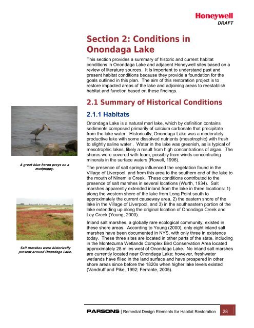
DRAFTA great blue heron preys on amudpuppy.Salt marshes were historicallypresent around <strong>Onondaga</strong> <strong>Lake</strong>.Section 2: Conditions in<strong>Onondaga</strong> <strong>Lake</strong>This section provides a summary of historic and current habitatconditions in <strong>Onondaga</strong> <strong>Lake</strong> and adjacent Honeywell sites based on areview of literature sources. It is important to understand past andpresent habitat conditions because they provide a foundation for thegoals outlined in this plan. The aim of this restoration project is torestore impacted areas of the lake and adjoining areas to reestablishhabitat and function based on these findings.2.1 Summary of Historical Conditions2.1.1 <strong>Habitat</strong>s<strong>Onondaga</strong> <strong>Lake</strong> is a natural marl lake, which by definition containssediments composed primarily of calcium carbonate that precipitatefrom the lake water. Historically, <strong>Onondaga</strong> <strong>Lake</strong> was a moderatelyproductive lake with some dissolved nutrients (mesotrophic) with freshto slightly saline water . Water in the lake was greenish, as is typical ofmesotrophic lakes, likely a result from high concentrations of algae. Theshores were covered with foam, possibly from winds concentratingminerals in the surface waters (Rowell, 1996).The presence of salt springs influenced the vegetation found in theVillage of Liverpool, and from this area to the southern end of the lake tothe mouth of Ninemile Creek. These conditions contributed to thepresence of salt marshes in several locations (Wurth, 1934). Saltmarshes apparently extended inland from the lake in three locations: 1)along the western shore of the lake from Long Point south toapproximately the current causeway area, 2) the eastern shore of thelake in the Village of Liverpool, and 3) in the southeastern portion of thelake extending up along the original location of <strong>Onondaga</strong> Creek andLey Creek (Young, 2000).Inland salt marshes, a globally rare ecological community, existed inthese shore areas. According to Young (2000), only eight inland saltmarshes have been documented in NYS, with only three in existencetoday. These three sites are located in other parts of the state, includingin the Montezuma Wetlands Complex Bird Conservation Area locatedapproximately 28 miles west of <strong>Onondaga</strong> <strong>Lake</strong>. No inland salt marshesare currently located near <strong>Onondaga</strong> <strong>Lake</strong>; however, freshwaterwetlands have filled in the land surface and have prospered in othershore areas since before the 1820s when higher lake levels existed(Vandruff and Pike, 1992; Ferrante, 2005).PARSONS | Remedial Design Elements for <strong>Habitat</strong> Restoration 28
DRAFTMuskrat are currently present inthe Harbor Brook area.2.1.2 Biological CommunitiesVegetationThere are several incidental accounts of vegetation in and around<strong>Onondaga</strong> <strong>Lake</strong>, however, a thorough historical study of the lake’svegetation was never performed. Historical accounts of the 1800s and1900s written by botanists, European settlers, and garden clubs indicatethe presence of several plant species around <strong>Onondaga</strong> <strong>Lake</strong> moretypical of salt marshes and seashores (Beauchamp, 1869; Goodrich,1912; Wurth, 1934; Bye and Oettinger, 1969; Vandruff and Pike, 1992;McMullen, 1993). The lake’s high salinity fostered the growth of salttolerantplants (halophytes) including oak-leaved goosefoot(Chenopodium glaucum) and glasswort (Salicornia europaea).Other records indicate an abundance of tree species as well. Typical tocentral New York during this period were deciduous hardwoods,hemlock (Tsuga canadensis), and evergreens (Taylor, 1995). Althoughthe types and distribution of many plant species around the lake havebeen modified considerably over the last 150 years, silverweed(Potentilla anserina or Argentina anserina) (a species found in saltmarshes, shorelines, and open areas) is consistently abundant from asearly as the mid-1800s through today (McMullen, 1993).MammalsAbundant wildlife was also encountered in the area surrounding<strong>Onondaga</strong> <strong>Lake</strong> during this period. Henry Hudson and Samuel deChamplain wrote in their travel journals in 1656 about the abundance ofbears in the region. In one account, they describe how members oftheir party killed thirty bears in a single day. Their journal also describestheir finding a drowned animal-- a “wild cow…having horns like thestag’s.” Historians believe that the animal was probably a female elk(Cervus elaphus) or moose (Alces alces). Beaver (Castor canadensis)were also abundant in the region and were the source of pelts for theactive fur trade. Other writings indicate that this area of central NewYork was also home to several species that no longer live in the region,including the gray wolf (Canis lupus), elk, and the Canadian lynx (Lynxcanadensis) (Ste. Marie among the Iroquois, 2006).FishThe earliest known report documenting fish in the lake was written byFrench Jesuit Father Simon LeMoyne in 1654. He observed Atlanticsalmon (Salmo salar) (Beauchamp, 1908). Other early reports suggestthat coldwater species, such American eel (Anguilla rostrata) and<strong>Onondaga</strong> <strong>Lake</strong> “whitefish” were once abundant in <strong>Onondaga</strong> <strong>Lake</strong>(Nemerow, 1964; Webster, 1982; Tango and Ringler, 1996). A relativelyrecent report suggests that the culturally significant whitefish speciesrecorded in early accounts was likely a cisco (Coregonus spp.) and nota whitefish, based on the historic distribution of the lake herringthroughout the Oswego River watershed (NYSDEC, 2004). Recentinformation indicates this species may have been Coregonus artedi orpossibly C. zenithicus (Arrigo 1996), although Siniscal (2009) providesfurther evidence that it was likely C. artedi.PARSONS | Remedial Design Elements for <strong>Habitat</strong> Restoration 29
DRAFTTransient cold waterfish, such as this browntrout, have beenincluded in the habitatdesigns for the <strong>Lake</strong>.There are general accounts for a few other fish species in the lakebefore 1900. In 1825, yellow perch (Perca flavescens) were recordedby DeKay (Beauchamp, 1908). Nemerow (1964) draws on an accountfrom 1866 where “large numbers of pike, perch, bass, and bullheads”were caught by fishermen. In 1872, “salmon, trout, and bass” were alsostocked in the lake (Nemerow, 1964). Salmon, along with the<strong>Onondaga</strong> <strong>Lake</strong> whitefish, supported a commercial fishery that operatedon the lake until 1890, with the whitefish lost by 1897 (Tango andRingler 1996). The Atlantic salmon was forced out of existence(extirpated) from <strong>Onondaga</strong> <strong>Lake</strong> by the late 1800s, most likely becauseof mill dam construction and deforestation (Webster, 1982).In 1927, J.R. Greeley performed the first documented scientific study offish in <strong>Onondaga</strong> <strong>Lake</strong> (Ringler et al., 1996). He collected twelve fishspecies from <strong>Onondaga</strong> <strong>Lake</strong>, including the white sucker (Catostomuscommersonii), shorthead redhorse (Moxostoma macrolepidotum),common carp (Cyprinus carpio), golden shiner (Notemigonuscrysoleucas), emerald shiner (Notropis atherinoides Rafinesque),bluntnose minnow (Pimephales notatus), grass pickerel (Esoxmericanus.vermiculatus), banded killifish (Fundulus diaphanus),largemouth bass (Micropterus salmoides), pumpkinseed sunfish(Lepomis gibbosus), and yellow perch. Compared with other local lakesof similar size and volume, however, the lake’s fish population wasconsidered neither diverse nor plentiful. This lack of diversity was notedwhen a second fish survey conducted in 1946 revealed that 90% of 400fish collected in a three day-period were common carp. The remaining10% accounted for a total of 13 different species (Ringler et al., 1996).Little scientific data are available for the early and mid-1960s except fornotes on trap net catch data from NYSDEC from June 1963 and June1964 (Ringler et al., 1996). The next comprehensive survey occurred in1969 by Noble and Forney, who surveyed the fish community of<strong>Onondaga</strong> <strong>Lake</strong> using trap nets and gill nets (Noble and Forney, 1969;Ringler et al., 1996). This study identified 14 species of fish anddescribed the fishery as a warm-water fish community with similargrowth rates as other warm-water lakes in the northeastern UnitedStates. During surveys in the early 1980s by NYSDEC, 22 species werecollected, dominated by white perch (Morone americana) and alewife(Alosa pseudoharengus) (Chiotti, 1981; Ringler et al., 1996). Inaddition, the overall dominance of common carp in the fish communitydeclined sometime between the 1946 and the 1980 surveys. Therewere low rates of reproduction in the majority of fish species, except inwhite perch.2.2 Changes from Historical Conditionsaround <strong>Onondaga</strong> <strong>Lake</strong>Since the late 1700s increased settlement, urbanization and industrialdevelopment have increased pressures on <strong>Onondaga</strong> <strong>Lake</strong> and itssurrounding habitats. These shifts have impacted the sustainability,population and diversity of various habitats. A brief outline of the humanPARSONS | Remedial Design Elements for <strong>Habitat</strong> Restoration 30
DRAFTactivity around the lake, along with some of the specific changes theactivities have had on the lake, are discussed in the subsections below.The Phoenix Dam, located inPhoenix, New York, controls thelevel of <strong>Onondaga</strong> <strong>Lake</strong>.2.2.1 Water Level and Surface AreaModificationsAn explorer’s report from 1856 (Watson, 1856) indicates that the lakehad a shallow outlet (about 1 foot) with continuous rapids down most ofits length. The natural marl build up that occurred during late summerand early fall when calcium carbonate precipitated from the lake waterresulted in the lake water level being approximately two feet higher thanthe Seneca River (Ferrante, 2005). In 1822, in an effort to improvenavigation between the Seneca River and the lake, officials from NYSdredged and straightened the outlet. The change caused the lake levelto drop 2 feet and reduced the surface area of the lake by 20%(Ferrante, 2005).Around this time, local state officials also drained the wetlands at thesouthern end of the lake to help eliminate the breeding grounds formalarial mosquitoes. The draining of these wetlands on the southernend of the lake opened the area near the salt springs for urbansettlement, and this area continued to grow as railroads wereconstructed throughout the region. In 1840, the construction of theSyracuse Northern Railroad impacted the lake itself, creating changes inthe southeastern shoreline alignment, resulting in the narrow shorelineconditions that we have today in that area (Hohman, 2004).Continued changes to the lake level and surface area occurred as thearea around the lake became more urban and populations continued toincrease. As roads were constructed, cut material was dumped into thelake, altering the shoreline and impacting the surface area. The lakelevel was altered again in early 1915 when the NYS Barge Canal wasconstructed. This new canal, along with the raising of the Phoenix Damby 3.5 feet, raised the elevation of the lake to its pre-1822 elevation.Many of the wetland areas around the lake were also filled in bycontinued development (Ferrante, 2005). Due to various stages ofindustrialization that began in the mid 1800s, other changes includedthe creation of Wastebed B and the East Flume (54 acres), Wastebeds1-8 (397 acres) and the in-lake waste deposit (ILWD) (98.5 acres).Some of these activities resulted in surface area modifications to thelake. Additional changes to the lake surface area occurred in the 1950swith the construction of Interstate 690 (I-690). Fill material fromconstruction activities was placed along the shoreline (area alongRemediation Area C [SMU 2]) in the southern portion of the lake (Efflerand Harnett, 1996). In 1977, the surface area of the lake was againaltered by the installation of a sewage force main, which resulted in thefilling in of almost four acres of the lake in the vicinity of RemediationArea C (SMU 2) (Hohman, 2004). The creation of Wastebed B andWastebeds 1 through 8 also resulted in surface area modifications tothe lake.Some of the most recent developments to the surface area of the lakeare due to the early stages of remediation of <strong>Onondaga</strong> <strong>Lake</strong>. In 2007PARSONS | Remedial Design Elements for <strong>Habitat</strong> Restoration 31
DRAFTthe construction of the Willis Semet barrier wall and groundwaterextraction system began along the south side of the lake near I-690 toprevent the flow of upland groundwater from entering the lake. This wallincreased the width of the shoreline in this area by several hundred feetand shifted the alignment of the shoreline, slightly decreasing the lake’swater surface area. <strong>Lake</strong> levels have not been dramatically impacted;however, since the water level is controlled by the NYS Barge CanalSystem. Changes to the lake level since 1822 are summarized on Table2.1. Figure 2.1 illustrates how the lake footprint has been altered byurbanization and industrialization by depicting the shoreline in 1898,1908, 1938, and today.2.2.2 DevelopmentWhite City ScenicRailway was apopular touristattraction.As the canal and railroads made the lake more accessible in the late1800s, the area around <strong>Onondaga</strong> <strong>Lake</strong> became a popular touristdestination, and several lakeside resorts were constructed along thelakeshore. Many of these resorts contained amusement parks with avariety of attractions including roller coasters, carousels, dancepavilions, shooting galleries and bowling alleys. One of the morepopular resort areas was the Iron Pier, which was located near thepresent site of the Carousel Mall. The resorts were popular with touristsuntil the early 1900s when industrial sites started to populate theshoreline areas more commonly.The area near <strong>Onondaga</strong> <strong>Lake</strong> has had an industrial presence since thelate 1700s and steadily increased with time as various industries tookadvantage of the naturally occurring salt in this region for use in themanufacture of various chemicals and chemical processes. The earliestdocumented industry was the salt industry which operated from 1793 to1908 (Hohman, 2004). The region lost its monopoly on salt productiondue to changing industrial demands for salt and the discovery of largesources of salt in other areas of the United States. By 1920, the regionaround <strong>Onondaga</strong> <strong>Lake</strong> was a national center of manufacturing forPARSONS | Remedial Design Elements for <strong>Habitat</strong> Restoration 32
DRAFTmetal products, automobiles, typewriters, pottery, and other smallmachinery (de Laubenfels, 1977). By 1950, 139 industries used<strong>Onondaga</strong> <strong>Lake</strong> for waste disposal (Ferrante, 2005), with the SolvayProcess Company being a significant contributor.As industry increased around the <strong>Onondaga</strong> <strong>Lake</strong>, noticeable changesto the integrity of the lake became noticeable, particularly in itsproductivity rates. For instance, prior to human impacts, <strong>Onondaga</strong><strong>Lake</strong> was moderately nutrient rich (mesotrophic) and fresh to slightlysaline (Rowell, 1996). The high levels of productivity prevalent in thelake after the mid-1800s are correlated with cultural activity. The lakebecame highly nutrient rich and very productive (eutrophic) during theearly to mid-1800s and excessively nutrient rich and very highlyproductive (hypereutrophic) shortly after World War II due to increasednutrient inputs. <strong>Lake</strong> salinity started to increase in the early 1800s whenthe expansion of the local salt industry developed, and a much largerincrease occurred following the establishment of the Honeywell sodaash facility in 1884 (Rowell, 1996)."A century of industrial pollution, urbanization and municipal wasteimpacted the habitat in <strong>Onondaga</strong> <strong>Lake</strong>, thus influencing the types andnumber of species as well as the location of where species are able tolive in these altered conditions. Available fish spawning areas, forexample, have been modified due to reduced plant life in both the lakeand its tributaries because of lower levels of dissolved oxygen,increased turbidity, elevated ammonia concentrations, salinity andcontamination. By 1900, both Atlantic salmon and whitefish (or lakeherring [Coregonus artedi]) were absent from <strong>Onondaga</strong> <strong>Lake</strong> (Tangoand Ringler, 1996). This was likely due to many factors includingincreased number of dams in the watershed, deforestation, and at leastin part to increased anoxia in the deeper waters of the lake duringsummer when the overlying warmer water does not mix with theunderlying cooler water (i.e., stratification). The continued lower levelsof dissolved oxygen in the lower waters of the lake limit the availability ofsuitable habitat for cold water species, such as salmonids, in the lake.In 1927, surveys identified only 12 different species and in 1946, 14species were recorded. As stated in the above section, in the 1950s,fishery surveys showed that more than 90% of the total fish netted in<strong>Onondaga</strong> <strong>Lake</strong> were common carp. No information was collectedregarding smaller size classes. By 1969, a survey described the fisheryas a warm-water fish community with 14 species captured (Noble andForney, 1969).The rarity of some species in <strong>Onondaga</strong> <strong>Lake</strong> is linked with regionalimpacts dating back over 100 years (Tango and Ringler, 1996). Mills etal., (1978) indicate that pickerel (Esox niger) and pike (Esox lucius) werecommon predators in the region in the late 1800s and early 1900s.However, draining of area wetlands and the construction of the BargeCanal system also reduced the availability of spawning habitats, andtheir abundances declined (Mills et al., 1987). The eel fishery of theOneida River, into which <strong>Onondaga</strong> <strong>Lake</strong> waters flow (Effler andHennigan 1995), was abandoned shortly after 1913 as eels alsodeclined in the region (Mills et al., 1987).PARSONS | Remedial Design Elements for <strong>Habitat</strong> Restoration 33
DRAFTIndustrial discharges resulting from the Solvay manufacturing processalso resulted in habitat changes associated with sediment conditionswithin the lake (Effler and Harnett, 1996) and what is referred to as theILWD in Remediation Area D (SMU 1 and portions of SMUs 2 and 7).These conditions are described further in Section 2.3.1.The shoreline of<strong>Onondaga</strong> <strong>Lake</strong> has seenmultiple configurationsover the past century.Since the 1900s, the cumulative effects of human-induced disturbances,such as tree clearing, agriculture, filling, dam construction,industrialization, and urbanization, have reduced terrestrial, floodplain,and aquatic habitats and altered species biodiversity within thewatershed surrounding the lake as well. Some wildlife, such as wolves,bears, and bobcats have long been lost from central New York and the<strong>Onondaga</strong> <strong>Lake</strong> area. The loss of large tracts of forest and wetlandsover the last two centuries has resulted in the fragmentation of naturalcommunities (VanDruff and Pike, 1992). Existing land use/land cover isshown on Figure 2.2. This map illustrates how natural areas have beenfragmented due to urban development.In addition to impacting fish and wildlife habitat, manufacturing alsoimpacted how humans used the lake as a community and recreationalresource. The manufacturing activities around <strong>Onondaga</strong> <strong>Lake</strong> led tocontinued population growth in Syracuse, but contributed to the demiseof the tourist industry and decreased recreational opportunities on thelake.By 1940, New York State no longer authorized permitted swimmingbeaches or sanctioned swimming areas at <strong>Onondaga</strong> <strong>Lake</strong> due to highbacteria and poor visibility. In 1970, the NYSDEC in concert with theDepartments of Health and Agriculture and Markets, closed <strong>Onondaga</strong><strong>Lake</strong> to all fishing due to the high levels of mercury contamination.<strong>Onondaga</strong> <strong>Lake</strong> was reopened to recreational fishing in 1986 on a“catch and release” basis. The New York State Department of Health(NYSDOH) health advisory for the lake at the time was to eat no fishfrom the lake. In 1999, some additional changes in the health advisoryPARSONS | Remedial Design Elements for <strong>Habitat</strong> Restoration 34
DRAFToccurred. For 2009-2010, NYSDOH advises the public to consume nowalleye, no bass greater than 15 inches in length, and to eat no morethan one meal a month of all other species and smaller bass due tomercury, dioxins, and PCBs.These advisories continue to be updated, and new information can befound on the NYSDOH web site (http://www.health.state.ny.us).2.2.3 Present-day Community BenefitsSalt City Bassmasters fish on<strong>Onondaga</strong> <strong>Lake</strong>.MinkDespite the impact of the industrial activities over the past century,<strong>Onondaga</strong> <strong>Lake</strong> continues to provide many beneficial aspects to thecommunity. Some of these community benefits are listed below (TAMS2002b):• Boating -The marina located on the eastern shoreline of the lake,and the lake’s connection to the Seneca River, facilitate use ofthe lake by boaters. <strong>Onondaga</strong> <strong>Lake</strong> is home to the <strong>Onondaga</strong><strong>Lake</strong> Yacht Club, the Syracuse University Crew teams, theSyracuse Chargers Rowing Club, and several local schoolrowing teams. Canoes and kayaks are available to the generalpublic for rental. The lake has also received national attention asit was the recent site of the U.S. Open of Watercross personalwatercraft races in May, 2009.• Fishing – <strong>Onondaga</strong> <strong>Lake</strong> contains numerous fish speciessought after by recreational anglers. <strong>Onondaga</strong> County hoststhe yearly Fishing for Dollars tournament, and local groups suchas the Salt City Bassmasters routinely fish on the lake. In 2007,ESPN hosted the 2007 Bassmasters Memorial FishingTournament on <strong>Onondaga</strong> <strong>Lake</strong>. The North American FishingClub lists the <strong>Lake</strong> as one of the country’s top locales for bass(www.onondagacountyparks.com).• Hunting – Where permission has been granted by theappropriate landowner and when laws permit, the shores of<strong>Onondaga</strong> <strong>Lake</strong> provide hunting and trapping opportunities.Waterfowl and deer populations are abundant enough to supporthunting. In addition, mink, fox, and other mammals can betrapped.• Recreation – More than 75% of the shoreline of <strong>Onondaga</strong> <strong>Lake</strong>is owned by <strong>Onondaga</strong> County and is classified as parkland.Last year, 1.3 million visitors used the park for picnicking,walking, jogging, roller blading, and bicycling (Geraci, 2009). Inaddition, the recreational-use path along <strong>Onondaga</strong> <strong>Lake</strong> Park isbeing expanded along the southern shoreline across NinemileCreek. The remainder of the lakeshore is currently beingevaluated to create a continuous trail around the entire lake.• Swimming – In the past, the lake has been used for recreationalswimming. The northern two-thirds of the lake is classified byNYS for direct recreational contact (i.e., Class B Waters), butswimming from shore is prohibited because of regulationsPARSONS | Remedial Design Elements for <strong>Habitat</strong> Restoration 35
DRAFT<strong>Onondaga</strong> <strong>Lake</strong> Parkway is a popularspot for picnics and family fun.Metro’s upgrades have greatly improvedthe water quality in <strong>Onondaga</strong> <strong>Lake</strong>.requiring a dedicated bathing beach with supervision, safetyequipment, and protection from boats and jet skis.• Inner Harbor – New development has occurred near thesouthern shore of <strong>Onondaga</strong> <strong>Lake</strong>, along <strong>Onondaga</strong> Creek andthe Barge Canal, as part of the Syracuse Inner Harbor Project.Approximately 42 acres of land, which is currently owned by theNYS Canal Corporation, are being developed for recreationaland commercial uses by the <strong>Lake</strong>front Development Corporation(LDC).• Commerce – <strong>Onondaga</strong> <strong>Lake</strong> has long served as a backdrop fora number of commercial and industrial sites. Historically, theshores of <strong>Onondaga</strong> <strong>Lake</strong> were extensively developed byrestaurants, resorts, and eventually industries. The salt industry,in particular, flourished due to the lake’s central location in thestate, the salt deposits and the presence of water. Otherindustries also developed around the lake, some of which arestill in operation today. Industrial sites have been converted todevelop commercial properties in the vicinity of the lake,including Carousel Mall, the Regional Farmers Market, and theNYS Fairgrounds parking area.• Tourism – The city of Syracuse, <strong>Onondaga</strong> County, and NewYork State are attempting to increase the tourism industry inSyracuse. The ongoing expansion of Carousel Mall, thedevelopment of the Inner Harbor, and the lakeside trail are allpart of this effort. The lake is central to these efforts as a scenicand recreational area.• Education – The Liverpool school district has developed ascience program focused on <strong>Onondaga</strong> <strong>Lake</strong>. Fifth graders takepart in the “Living <strong>Lake</strong>” program where they learn aboutecosystems and habitats in and around the lake.• Stormwater Retention – The lake and its surrounding wetlandsand tributaries are used by <strong>Onondaga</strong> County for stormwaterdischarge. <strong>Onondaga</strong> County plans to implement sustainablemeasures to help decrease stormwater run-off and promotewater retention. The use of green initiatives throughout thecounty, such as living roof tops, rain barrels, and porouspavements, will reduce runoff into the sewers and offersustainable flood control (Knauss, 2009).2.2.3 Metro/CSO Loadings/ImprovementsThe City of Syracuse installed its first centralized sewage treatmentsystem in 1896. The facility was located just south of the Barge Canalbetween Pulaski and Van Rensselaer Streets (G.M. Hopkins, Co.,1938). Primary treatment of sewage began in 1925. In 1950,<strong>Onondaga</strong> County established the Metropolitan Sewer District, whichencompassed the City of Syracuse and some surrounding suburbanareas. In 1960, the district completed construction of a large primarysewage treatment plant, Metro, along the southern shore of the lakePARSONS | Remedial Design Elements for <strong>Habitat</strong> Restoration 36
DRAFTimmediately south of the mouth of <strong>Onondaga</strong> Creek. By 1979, the citybegan nutrient removal and secondary treatment (Ferrante, 2005).Effluent wastewater is discharged to the lake via a 94.5 inch (7.875 feet)diameter shoreline outfall. Flows in excess of 150 million gallons perday were historically discharged via the old 59.1 inch (4.925 feet)diameter deep water outfall. The two outfalls are connected, and waterflows through both pipes during rain storms (Effler, 1996).This effluent is a source of domestic point-source compounds such asammonia, phosphorus, and nitrate to the lake. Additionally, duringheavy storm periods, a mixture of untreated sewage and street runoffoverflows from the sewer system through combined sewer overflows(CSOs), which discharge primarily into <strong>Onondaga</strong> Creek and HarborBrook and ultimately drain into <strong>Onondaga</strong> <strong>Lake</strong> (NYSDEC and USEPA,2005).NYSDEC and the Metro Sewage Treatment <strong>Plan</strong>tBased on these water quality issues, <strong>Onondaga</strong> County entered into anAmended Consent Judgement (ACJ) in January 1998 with the State ofNew York and the Atlantic States Legal Foundation (ASLF). Theconditions of the judgment require that the County upgrade thetreatment plant and develop a CSO program that (1) eliminates orcaptures for treatment at least 85% of the volume of the combinedsewage collected in the system during precipitation events, (2)eliminates or minimizes floating substances in the lake from CSOs, and(3) achieves water quality standards for bacteria in the lake (ODCWEP,2005).<strong>Onondaga</strong> County designed, tested, and constructed modifications andadditions to the Metro facility that enables year-round nitrification ofammonia and phosphorus removal. The County made the necessaryupgrades ahead of schedule, and based on the modifications andadditions made by the County, the effluent meets or exceeds waterquality standards earlier than originally anticipated.In January 2004, a biological aerated filter system (BAF) was broughtonline to provide year round treatment of ammonia. The plant met theStage 2 ammonia limits on schedule (beginning in March 2004) andbegan meeting the Stage 3 ammonia limits in March 2005, over 7 yearsahead of schedule. More recently, the high rate flocculated settlingsystem (HRFS) for phosphorus removal came online. Throughoperation of the HRFS, the County is working to meet the Stage 2phosphorus limits.Improvements to the county's wastewater collection and treatmentsystem at Metro are responsible for the improved water qualityconditions in the <strong>Lake</strong>. Significant investment in wastewater treatmenttechnology has achieved far lower discharges of wastewater-relatedpollutants, particularly ammonia and phosphorus (OCDWEP, 2009).<strong>Onondaga</strong> County is also improving the water quality in <strong>Onondaga</strong> <strong>Lake</strong>with its many CSO projects. Regional treatment facilities remove anyfloating material and disinfect sewer overflow, sewer separation divertscontaminated sewer water away from storm sewers, floatable controlPARSONS | Remedial Design Elements for <strong>Habitat</strong> Restoration 37
DRAFTfacilities remove floating debris from water that may enter the lake, andan increased storage and transport capacity moves a larger volume ofpossibly contaminated water through pipes and into underground tanks.Together, these projects will reduce human health risks associated withthe discharge of untreated sewage into <strong>Onondaga</strong> <strong>Lake</strong> and greatlyimprove overall water quality.The barrier wall preventscontaminated groundwater fromentering <strong>Onondaga</strong> <strong>Lake</strong>.2.2.4 Remedial Actions/IRMsHoneywell has effectively completed the remediation at the LCP site inthe Town of Geddes and an IRM at the lakeshore—both of which havedirectly reduced the migration of contaminants to <strong>Onondaga</strong> <strong>Lake</strong>.Under direction of NYSDEC, the cleanup program at the LCP site (aformer Honeywell property that was once one of two major sources ofmercury contamination to the lake) involved a combination of mercuryremoval from soil on the former plant property, excavation ofcontaminated sediments in surrounding areas, installation of an onsitegroundwater collection system, and the construction of an f undergroundbarrier wall to prevent any future contaminant migration from the siteThe barrier wall extends down to bedrock and ranges from 30 to 70 feetdeep. The LCP remediation was completed in 2007 and the lakeshoreIRM was completed in late 2006. The deep groundwater portion of thelakeshore IRM may be conducted at a later date based on ongoing datacollection and evaluation.The primary habitat-related benefits resulting from this action areassociated with the remediation and habitat restoration of nine acres ofadjacent wetland areas and the West Flume. These wetlands areconnected via culverts to the West Flume, which ultimately drain to thelake via Geddes Brook and Ninemile Creek. Before remediation, thesewetlands areas were low-quality wetlands for several reasons:• substrate consisting predominantly of fill material;• dominance of almost uniform stands of invasive Phragmites;• lack of a connection to downstream aquatic systems;• location within the upper end of the drainage system; and• the disturbed nature of adjacent habitats.These wetlands were fully restored and enhanced to a variety of habitattypes including a wet meadow/scrub-shrub fringe, emergent wetland,aquatic bed, open water, and drainage channel.These habitat types were created by the development of various waterdepth zones according to the wetland restoration plan (Parsons, 2004a).In order to limit invasive species, the restoration plan placed anemphasis on the development of aquatic bed and deep emergent marshhabitat types. The majority of wetland characterization at the LCP Siteis ongoing, but to date, the following observations have been maderegarding the restored and enhanced wetlands:• Successful growth from plantings of trees and shrubs andPARSONS | Remedial Design Elements for <strong>Habitat</strong> Restoration 38
seeding efforts;• Emergent and aquatic bed wetland habitats have beenestablished with some open water habitat;DRAFT• Wet meadow and scrub-shrub habitat has been established onthe fringe of wetlands;• Phragmites growth has been limited/controlled within thewetlands;• The hydrologic connection between LCP Site wetlands and theWest Flume has been improved; and• Physical structure in this wetland has been improved with theaddition of trees and rocks along the edges of the wetlands.Honeywell has also made significant progress with installing a hydraulicbarrier wall and groundwater treatment plant, as part of the Willis/SemetBarrier IRM, to prevent contaminated groundwater from entering thelake. Approximately 2,800 feet of an underground barrier wall,constructed of interlocking steel panels, has been installed near thesouthwest shoreline of <strong>Onondaga</strong> <strong>Lake</strong> since 2006. Honeywell alsocompleted construction of a groundwater treatment plant in 2006, oneyear ahead of schedule, to collect, process, and treat contaminatedgroundwater behind the underground barrier wall. Due to the lack of riprapshoreline along the lake in this area the IRM has had minimaldisruption on the existing habitat. See Section 3.2.3 for further detailson this IRM.Green frogs are currently presentaround <strong>Onondaga</strong> <strong>Lake</strong>.2.3 Existing <strong>Habitat</strong>sThis section summarizes existing habitat conditions within and adjacentto <strong>Onondaga</strong> <strong>Lake</strong>. In sub-sections 2.3.1 through 2.3.5, habitatconditions are described for five general areas: littoral zone (shallowwater sediments), profundal zone (deep water sediments), wetlands,riparian zone (shoreline), and tributaries. Descriptions of existingbiological communities, such as fish, aquatic plants, and wildlife areprovided in Section 2.4. Information on endangered, threatened, andSection 2.4.<strong>Onondaga</strong> <strong>Lake</strong> covers approximately 4.6 square miles (3,000 acres), isapproximately 4.5 miles long and 1 mile wide, and has an average waterdepth of 36 feet. The lake has a northern basin and a southern basinthat have maximum water depths of approximately 61 and 65 feet,respectively. The basins are separated by a saddle region at a waterdepth of approximately 56 feet. The lake is characterized by anearshore shelf (less than 12 feet deep) which represents about 25% ofthe surface area of the lake. This nearshore shelf is bordered by asteeper offshore slope in water depths of 12 to 24 feet (TAMS, 2002a).<strong>Onondaga</strong> <strong>Lake</strong> is part of a state system of canals maintained by theNYS Canal Corporation, which is part of the NYS Thruway Authority. Adam located approximately 15 miles downstream along the OswegoRiver in Phoenix, New York, maintains the water level in the lake. Thecurrent average surface elevation of <strong>Onondaga</strong> <strong>Lake</strong> is 362.8 feetPARSONS | Remedial Design Elements for <strong>Habitat</strong> Restoration 39
DRAFT(NAVD 1988). NAVD 1988 is the most current vertical control datumused for surveying locations in North America and is used for referencedue to its universal application for land and water surveying andmapping.The current average elevation of the lake has been consistent for thepast 30 years, however, the lake level can change seasonally due tospring run-off and dry summers as well as daily due to weather events.The lake is generally at its highest elevation in the early spring due toincreased tributary flows and at its lowest elevation during the summermonths. Additional lake elevation data are provided in Table 2.2The northern two thirds of the lake are classified by the State of NewYork as Class B waters, while the southern third of the lake and the areaat the mouth of Ninemile Creek are classified as Class C waters (seeFigure 1.2). Best usages for these waters are defined as:• Class B – “primary and secondary contact recreation and fishing.These waters shall be suitable for fish propagation and survival”(6 NYCRR Part 701.7).• Class C – “fishing. These waters shall be suitable for fishpropagation and survival. The water quality shall be suitable forprimary and secondary contact recreation although other factorsmay limit the use for these purposes” (6 NYCRR Part 701.8).<strong>Habitat</strong>s in the lake are influenced by water temperature, which variesseasonally. Like many inland northern lakes, the water of <strong>Onondaga</strong><strong>Lake</strong> does not fully mix during summer. The lake is stratified, meaningthat the upper layer of relatively warm water does not mix with the layerof cooler waters at the bottom of the lake. Summer stratification is mostpronounced from May through mid-October due to temperature effectson water density.During summer, the colder denser water, referred to as the hypolimnion,is unable to mix with the overlying warmer less dense water, referred toas the epilimnion. The boundary between these two layers is called thethermocline or metalimnion and is the region in the water column wherethe temperature changes most rapidly with depth. In <strong>Onondaga</strong> <strong>Lake</strong>,the metalimnion is located at approximately 30 feet (9 meters) below thewater surface, although this varies seasonally from approximately 16 to33 feet (5 to 10 meters). The upper, warmer waters continue to bemixed by wind and wave action, while the lower, cooler waters arerelatively isolated beneath the metalimnion.PARSONS | Remedial Design Elements for <strong>Habitat</strong> Restoration 40
DRAFTThis stratification of the lake is important because it determines how flowfrom tributaries and from the Metro discharge impact in-water habitats.During summer stratification inflow from the tributaries is incorporatedinto the upper layer (epilimnion) rather than throughout the entire lake,and occasionally into the metalimnion if tributary flows are saline.During periods of weak or no stratification, as typically occur duringwinter months, plunging flows from Ninemile and <strong>Onondaga</strong> Creeks mayenter the deeper waters of the lake directly.<strong>Onondaga</strong> <strong>Lake</strong> is stratified duringthe summer months, meaning thatwarm water lies on top of coolwater.Note that oxygen decreases withwater depth, as illustrated by theline graph in the graphic to theright.In conjunction with these processes, the hypolimnion receives organicand inorganic solids that settle from the epilimnion toward the lakebottom. As the summer progresses, biodegradation of the organicsolids deplete the oxygen in the hypolimnion, creating anoxic conditions.The presence of an anoxic hypolimnion is not uncommon in stratifiedlakes; however, oxygen depletion in the hypolimnion of <strong>Onondaga</strong> <strong>Lake</strong>was historically made worse by loading of phosphorus to the lake fromtributaries and the Metro <strong>Plan</strong>t discharge (Effler and Whitehead, 1996).Phosphorus is the critical nutrient that promotes the growth orproductivity of phytoplankton, which in turn increases the organicloading of settling solids to the hypolimnion. Increased phytoplanktonproductivity also leads to decreased water clarity (due to the high massof phytoplankton in surface water). Recent upgrades to Metro haveresulted in reduced phosphorus loading and are associated withsignificant improvement in the extent and duration of oxygen depletion(OCDWEP, 2009).Another characteristic about <strong>Onondaga</strong> <strong>Lake</strong> is that waters within thelake are more saline than in most inland lakes. Solvay Wastebeds 1through 15 as well as Solvay waste that was disposed of directly in thelake and at other locations along and near the lakeshore are known tocontribute calcium, sodium, and chloride to Ninemile Creek and/or thelake. Figure 4.1 illustrates the areas within the lake that contain Solvaywaste as the substrate. The ILWD comprises approximately 98.5 acresin Remediation Area D. There are approximately 45 acres of SolvayPARSONS | Remedial Design Elements for <strong>Habitat</strong> Restoration 41
DRAFTwaste in Remediation Area B and 1 acre is located within RemediationArea A.In addition, naturally occurring salt brine, which was collected andevaporated in the vicinity of <strong>Onondaga</strong> <strong>Lake</strong> for many years, affectsboth groundwater and nearby surface water quality. Natural salt springspresent near the lake result in saline discharges. The United StatesGeologic Survey (USGS) documented a saline spring in <strong>Onondaga</strong>Creek between Kirkpatrick and Spencer Streets (Kappel, 2003);however, the daily load (on the order of 10 tons [9,000 kilograms]) is aminor contribution to the salt budget of the lake. According to theGeddes Brook/Ninemile Creek RI Report the daily total dissolved solidsload from Ninemile Creek to the lake is on the order of 440 tons(400,000 kg) based on two base-flow sampling events in 1998 (TAMS,2003b).For remediation purposes, the sediments in the lake are divided into twomain regions: the littoral zone (shallower area) and profundal zone(deeper area). For purposes of this project, the littoral zone has beendefined as sediments from the shoreline out to 30 feet of water that arein contact with the epilimnion, which is the uppermost warm-water layeras shown in the graphic presented above. The profundal zone includessediments in the deep basins in more than 30 feet of water that are incontact with the hypolimnion, which are the deeper, colder, and denserwaters. The intent of the littoral zone and profundal zone designationsis to distinguish between the different biological, physical, and chemicalprocesses of the epilimnion and hypolimnion.<strong>Onondaga</strong> <strong>Lake</strong>The lake sediments aredivided into two zones at awater depth of 30 ft—littoral(shallow zone shown as lightblue) and profundal (deeperzone shown as dark blue).Other <strong>Onondaga</strong> <strong>Lake</strong> reports divide sediments into different areasbased on characteristics of the sediments themselves. Johnson (1989)splits the sediments of <strong>Onondaga</strong> <strong>Lake</strong> into three zones: littoral (0 to15 feet [4.5 meters]), profundal (greater than 40 feet [12 meters]), andlittoroprofundal (between 15- and 40 feet [4.5- and 12 meters]).Littoroprofundal sediments are transitional between the two mainregions. Auer et al. (1996) define profundal sediment as located belowPARSONS | Remedial Design Elements for <strong>Habitat</strong> Restoration 42
DRAFT20 feet (6 meters) in lake depth relatively undisturbed, and not subject toresuspension or bioturbation.Ninemile Creek Delta2.3.1 Littoral ZoneThe littoral zone is considered the lake area between the shoreline and30 feet (9 meters) of water. Much of the sediment in water depths ofless than 15 feet (4.5 meters) consists generally of fine silts and clays,sand, and shell fragments (Johnson, 1989). Two major habitat typescomprise the littoral zone: submerged aquatic plants andunconsolidated bottom. The submerged aquatic plants habitat ischaracterized by the presence of plants that grow entirely under wateror have leaves that extend to and float on the water surface.High concentrations of calcite exist within the littoral sedimentsthroughout most of the lake due to past and present input of naturallycalcitic sediments from the tributaries and, while the former Allied (nowHoneywell) Main <strong>Plan</strong>t was operating from 1884 to 1986, calciteprecipitation in the lake. Additionally, erosion from the wastebeds alongthe shoreline contributed calcium carbonate and calcite to the lake.Oncolites are another form of calcite in littoral sediments of <strong>Onondaga</strong><strong>Lake</strong>. Oncolites are small, oval or irregularly rounded, calcareousconcretions that resemble elongated pebbles and occur in a variety ofwater environments around the world. Made up of calcium carbonateand a small fraction of organic material, they are found throughout thelittoral sediments of the lake, especially along the northeast, north, andnorthwest shorelines. Oncolites are of relatively low mass and,therefore, are readily moved by waves and currents. Eventually,oncolites become stationary if they amass to a sufficient size (Golubicand Fisher, 1975).While much of the littoral zone is considered non-depositional due towind and wave action, discrete areas at the mouths of the tributaries aredepositional. These areas, traditionally called deltas, are created whenthe tributary enters the lake, the flow rate drops sharply, and suspendedsolids settle to the lake bottom. Sediment in these areas accumulatesand reflects the composition of the suspended solids that weretransported by the tributary into the lake.Another historically depositional area within the littoral zone in thesouthwest corner of <strong>Onondaga</strong> <strong>Lake</strong> is an area referred to in the RODas the in-lake waste deposit (ILWD). The ILWD was formed primarilythrough the deposition of calcium carbonate and other wastes from theoverflow of dikes around Wastebed B and through discharges via theEast Flume. These discharges into the lake are believed to haveincluded a combination of cooling water, sanitary waste, Solvay waste,mercury wastes, and organic chemical wastes, which settled out andformed a large delta that is at a higher elevation than surrounding areasof the lake bottom. The approximate extent of the ILWD in the littoralzone, based on sediment core data collected during the RI andsubsequent pre-design investigations (Parsons, 2009a), is shown inFigure 1.2. The area of the ILWD in the littoral zone is approximately98.5 acres.PARSONS | Remedial Design Elements for <strong>Habitat</strong> Restoration 43
DRAFT<strong>Lake</strong> sturgeon currently exist in theprofundal zone of <strong>Onondaga</strong> <strong>Lake</strong>.2.3.2 Profundal ZoneAs described above, the profundal zone is defined as the deeper basinin more than 30 feet (9 m) of water that is in contact with thehypolimnion, which is the denser, cooler, anoxic water during lakestratification (TAMS, 2002a; Parsons, 2004). Profundal sediment ischaracterized by small particle size and relatively high moisture content,as well as relatively high concentrations of phosphorus, nitrogen, andorganic carbon (Auer et al., 1996).This sediment is comprised of two units (Effler et al., 1996). The firstunit extends to approximately 35 inches (90 cm) below the sedimentsurface and is composed of black clay with distinct layers or laminations.The laminations are attributed to deposition of calcite, clays, anddiatoms (silica) associated with erosion of the watershed, productivitycycles within the lake, and other annual events (Effler et al., 1996). Thepresence of layers or laminations in the depositional sediment indicatesthat the sediment is relatively undisturbed (i.e., not affected by windwaveresuspension or bioturbation).The second unit is comprised of dark gray clay called gyttja and wasobserved up to 16.4 feet (5 m) deep. Laminations are visible, althoughthey become less distinct over the upper portion of the gyttja unit.Occasional gastropod shells and wood fragments occur throughout theunit. The sediment is progressively darker as the upper unit isapproached (Effler et al., 1996).2.3.3 Shoreline and Wetland <strong>Habitat</strong>sThe <strong>Onondaga</strong> <strong>Lake</strong> shorelinenear Harbor Brook has beenmodified by industrial activityand urbanization.Both inland salt marshes and freshwater emergent and forestedwetlands occurred historically around the lake and along the majortributaries inland from the lakeshore. These wetlands were likelydiverse not only because of their undisturbed nature, but also becauseof the lack of the many invasive plant species that currently degrade thepresent wetlands in the area.PARSONS | Remedial Design Elements for <strong>Habitat</strong> Restoration 44
DRAFTScientists use soil samples fromwetlands around <strong>Onondaga</strong> <strong>Lake</strong>to help classify wetland types.There is little detailed information in the available literature concerningthe historical wetlands around the lake. While the lowering of the lakesurface in the 1820s likely affected some of these wetlands, filling forwastebed use, transportation, and industrial facilities eliminated much ofthe original wetlands around the lake. Some of the wetlands thatcurrently exist around the lake likely developed on disturbed soil or fillmaterial.Five NYSDEC-regulated wetlands occur along or near <strong>Onondaga</strong><strong>Lake</strong>’s shoreline. These wetlands (as shown on Figure 1.2) are locatedas follows: near the mouth of Sawmill Creek (SYW-1), near the mouthsof Harbor Brook (SYW-19), Ley Creek (SYW-12), Ninemile Creek(SYW-10), and along the northwest portion of the lake (SYW-6).State-regulated Wetland SYW-6 is being addressed as part of theNinemile Creek Dredge Spoils Area (DSA), Wetland SYW-10 as part ofthe Geddes Brook/Ninemile Creek site, and Wetlands SYW-12 andSYW-19 as part of Wastebed B/Harbor Brook site.A wetland survey was also performed for the Wastebeds 1 through 8Site. Details of this survey can be found in the revised <strong>Onondaga</strong> <strong>Lake</strong>Wetland/Floodplain Report (O’Brien & Gere and Parsons, 2009).Further delineations of these wetlands were performed during varioussite investigations, and were delineated using the methods presented inwetland delineation manuals authored by the U.S. Army Corps ofEngineers (Environmental Laboratory 1987) and NYSDEC (1995).These wetlands are illustrated on Figure 1.2.In addition, Honeywell performed a wetlands and floodplain assessmentin 2004 to characterize wetlands and floodplain adjoining <strong>Onondaga</strong><strong>Lake</strong> that could potentially be impacted by lake remedial activities. Theassessment was conducted in accordance with a NYSDEC-approvedwork plan (O’Brien & Gere and Parsons, 2004) and consistent withUSEPA’s policy on Floodplains and Wetlands Assessment for CERCLAActions (1985) (O’Brien & Gere, 2009).National Wetlands Inventory (NWI) wetlands as mapped by the USFWSare shown on Figure 2.3. These wetlands are somewhat different thanthe NYSDEC-regulated areas because of differences in classification.The USFWS used the Cowardin classification scheme (Cowardin et al.,1979) for its NWI mapping project. Based on the NWI map (USFWS,1978) for the study area, the <strong>Onondaga</strong> <strong>Lake</strong> shoreline is predominantlyclassified as lacustrine, littoral habitat. Lacustrine systems are habitatsthat are situated in topographic depressions; have less than 30% arealcoverage of trees, shrubs, or persistent emergents; and are typicallygreater than 20 acres in size (Cowardin et al., 1979). The littoralsubsystem is described under this system as habitat that extends fromthe shoreward boundary of a lacustrine system to a depth of 6.6 feetbelow low water or to a maximum extent of nonpersistent emergents(Cowardin et al., 1979). Examples of littoral habitats include aquaticbeds, nonpersistent emergents, and unconsolidated shore.<strong>Habitat</strong> classes depicted on the NWI map for the <strong>Onondaga</strong> <strong>Lake</strong> shoreinclude unconsolidated bottom and unconsolidated shore (USFWSPARSONS | Remedial Design Elements for <strong>Habitat</strong> Restoration 45
DRAFT1978, USFWS, 2009). The water regime modifiers (hydrologiccharacteristics) for the <strong>Onondaga</strong> <strong>Lake</strong>shore include permanentlyflooded, seasonally flooded, temporarily flooded, and intermittentlyexposed. Only one subclass, spoil(s), is listed for two of the littoralhabitats present along the eastern lakeshore. The shoreline area isfurther discussed in Section 2.3.4, below.Additional details regarding the wetlands near <strong>Onondaga</strong> <strong>Lake</strong> areavailable in the recent floodplain and wetlands report (O’Brien & Gere,2009). Table 2.3 presents a summary of the wetlands contiguous withthe lake and evaluated as part of other recent lake-related studies.Wetland SYW-1Wetland SYW-1 is located along the northeastern portion of <strong>Onondaga</strong><strong>Lake</strong>. It is a Class I wetland (NYSDEC Freshwater WetlandsClassification System (6 NYCRR Part 664.5) that is separated from thelake by the lake trails and the Willow Bay picnic area.A wetland is classified as a Class I wetland if any of the following criteriais met:• wetland is kettlehole bog;• wetland is a resident habitat of an endangered orthreatened animal species;• wetland contains an endangered or threatened plantspecies;• wetland supports an animal species in abundance ordiversity unusual for the state or for the major region ofthe state in which it is found;• wetland is a tributary to a body of water which couldsubject a substantially developed area to significantdamage from flooding or from additional flooding shouldthe wetland be modified, filled, or drained;• it is adjacent or contiguous to a reservoir or other body ofwater that is used primarily for public water supply, or it ishydraulically connected to an aquifer which is used forpublic water supply; and• wetland contains four or more of the enumerated Class IIcharacteristics.This wetland falls outside of the <strong>Habitat</strong> <strong>Plan</strong> boundary, but it has beenincluded due to its proximity to the lake. Sawmill Creek drains throughWetland SYW-1 and discharges into the lake in this area. SawmillCreek has a NYS water quality classification of B. The portion of SYW-1nearest the lake (south of the Thruway) is primarily a deciduous forestwetland. Dominant trees are green ash (Fraxinus pennsylvanica) andsilver maple (Acer saccharinum).Wetland SYW-19Wetland SYW-19, which is located along Wastebed B on the southwestlakeshore at the mouth of Harbor Brook, is a Class I (NYSDECPARSONS | Remedial Design Elements for <strong>Habitat</strong> Restoration 46
DRAFTFreshwater Wetlands Classification System) freshwater palustrinewetland. A jurisdictional wetland delineation of the SYW-19 area wasconducted in the summer of 2000 and summer of 2003 as part of theHarbor Brook Site Remedial Investigation/Feasibility Study (O’Brien &Gere, 2004). Wetland delineation findings are reported in JurisdictionalWetland Delineation Report, Harbor Brook Site (O’Brien & Gere, 2003)and summarized below.The SYW-19 area consists of four wetland areas (WL1, WL2, WL3, andWL4) located along the <strong>Onondaga</strong> <strong>Lake</strong> shoreline. WL1 and WL2 arelocated near the mouth of Harbor Brook, and WL3 and WL4 are locatednear the mouth of the Lower East Flume. Since these four wetlandareas are contiguous with the lake, the transitional area between thepalustrine and lacustrine habitats consist mostly of gravel-cobbleshoreline and Solvay waste shoreline, as further described below.Wetland 1 (WL1) runs along the southern shoreline of <strong>Onondaga</strong> <strong>Lake</strong>near the eastern end of Wastebed B and borders the eastern bank ofHarbor Brook. WL1 comprises approximately 7.1 acres. <strong>Onondaga</strong><strong>Lake</strong> forms the northern border and an abrupt rise in topography (i.e.,berm and railroad bed) defines the southern and eastern borders of thiswetland. WL1 is vegetated primarily with a monoculture stand ofPhragmites. Wetland soils were indicated via the presence of low matrixchroma and high organic content of the soil strata. Wetland hydrologywas indicated by the presence of saturated soils (O’Brien & Gere, 2003).Wetland 2 (WL2) is on the western side of Harbor Brook, opposite WL1.WL2 comprises approximately 2.8 acres. <strong>Onondaga</strong> <strong>Lake</strong> forms thenorthern border and a gentle rise in topography toward Wastebed Bdefines the western and southern borders of this wetland. Similar toWL1, the dominant vegetative species present at WL2 is common reed;however, portions of WL2 also contain grapevine (Vitis sp.), buckthorn(Rhamnus cathartica), box elder (Acer negundo), black willow (Salixnigra) and Eastern cottonwood (Populus deltoides). Low matrix chromaand organic streaking indicated wetland soils. Significant amounts ofSolvay waste were observed in the soil strata. Wetland hydrology wasindicated by the presence of saturated soils in the upper 1 ft of the soil(O’Brien & Gere, 2003).Wetland 3 (WL3) is just north of Wastebed B on the southern shore of<strong>Onondaga</strong> <strong>Lake</strong>. WL3 comprises approximately 1.7 acres. <strong>Onondaga</strong><strong>Lake</strong> forms the northern border and the Lower East Flume forms thewestern border of this wetland. The former bulkhead that wasconstructed to retain the material deposited into Wastebed B primarilydefines its southern border of WL3 (O’Brien & Gere, 2003). WL3 isvegetated primarily with common reed. Other vegetative speciesobserved include purple loosestrife (Lythrum salicara), buckthorn, andbox elder. Significant amounts of Solvay waste were observed withinthe soil strata. Wetland hydrology was indicated by the presence ofsaturated soils within 1 foot of the ground surface (O’Brien & Gere,2003).Wetland 4 (WL4) is an approximately 0.5-acre depression that isbounded to the west and south by the Lower East Flume and to thePARSONS | Remedial Design Elements for <strong>Habitat</strong> Restoration 47
DRAFTLey Creek and adjacent WetlandSYW-12north and east by <strong>Onondaga</strong> <strong>Lake</strong>. It exhibits greater vegetativediversity than the other three wetlands. However, the dominantvegetative species observed are similar to those of wetlands WL1, WL2,and WL3 and include, but are not limited to, common reed, purpleloosestrife, buckthorn, and box elder. Significant amounts of Solvaywaste were observed within the soil strata. Wetland hydrology wasindicated by the presence of saturation in 1 foot of the ground surface(O’Brien & Gere, 2003).Soils mapped for these wetlands consist predominantly of bed areas ofSolvay waste that may or may not be covered with vegetation (USSCS,1977). The drainage characteristics of these soils range from somewhatpoorly drained to poorly drained on the wastebed areas located nearlake level (USSCS, 1977). As noted above, the soils observed in WL2through WL4 during the wetland delineation effort were predominantly amixture of weathered Solvay waste material with varying proportions ofbrown silty loam and organic (decomposed plant matter) material. Insome instances, the presence of Solvay waste precluded the finding ofpositive indicators of hydric soils. Therefore, the delineation effortsfocused on the prevalence of positive indicators of hydrophyticvegetation and wetland hydrology.During the summer of 2000, sediment samples were collected in SYW-19 and areas located between SYW19 and the lake for the <strong>Onondaga</strong><strong>Lake</strong> RI. During the completion of the Wastebed B / Harbor Brook SiteRI, surface soil samples were collected from the WL1 area at a depth of0 to 6 inches and a depth of 0.5 – 1.0 ft. The surface soils werecollected in conjunction with soil boring locations and selected surfacesoil sampling locations. Also, surface soils and wetland soil sampleswere collected at unique locations during the RI. Additionalinvestigation was conducted in 2008 within SYW-19. Soil andporewater samples were collected for analysis at depths between 0 and20 ft bgs. VOCs, SVOCs, pesticides, and metals were detected atmultiple sample locations during both the RI (O’Brien & Gere, 2007) andthe 2008 investigation.Wetland SYW-12Wetland SYW-12 is located along the shoreline of <strong>Onondaga</strong> <strong>Lake</strong> northof the mouth of <strong>Onondaga</strong> Creek and northwest of Carousel Mall. Thiswetland consists of several wetland cells, with the two largest cellslocated between Ley Creek and <strong>Onondaga</strong> Creek and immediatelynorth of Ley Creek. SYW-12 is recognized by the NYSDEC as a Class Iwetland, and it covers approximately 42 acres and has vegetative covercontaining Phragmites and an area of floodplain deciduous forest.Portions of SYW-12 not included in this assessment (north of LeyCreek) have been documented as salt marsh habitat by the New YorkNatural Heritage Program (NYSDEC/TAMS, 2002).O’Brien & Gere conducted a jurisdictional wetland delineation at aportion of wetland SYW-12 as part of wetland/floodplain assessment inSeptember of 2004, and October and November of 2008. The portion ofSYW-12 delineated and identified by O’Brien & Gere in 2004 (WL 1),consists of approximately 17 acres south of Ley Creek and south andPARSONS | Remedial Design Elements for <strong>Habitat</strong> Restoration 48
DRAFTwest of the railroad tracks along the northeastern shoreline of<strong>Onondaga</strong> <strong>Lake</strong>. <strong>Onondaga</strong> <strong>Lake</strong> forms the western border of thiswetland. An abrupt rise in topography (i.e., berm and railroad bed)defines the eastern border of the wetland, and Ley Creek defines thenorthern boundary of this wetland area. This portion of SYW-12 is acombination of a monoculture stand of Phragmites and forestedfloodplain that comprise an overstory of predominantly easterncottonwood trees. As this wetland is contiguous with the lake, thetransitional area between the palustrine and lacustrine habitatsconsisted mostly of gravel-cobble shoreline and Solvay waste shoreline.Soils mapped for this wetland cell included made land (Ma) and cut andfill land (CFL) soils (USSCS 1977). According to USSCS (1977), Maconsists predominantly of bed areas of waste material, which may ormay not be covered with vegetation and CFL soils vary widely within<strong>Onondaga</strong> County.The portions of SYW-12 identified and delineated by O’Brien & Gere in2008 consist of two sub-wetlands (WL 2 and WL 3) south of Ley Creekand east of the railroad tracks that border WL 1. WL 2 is a 1.1-acretriangular-shaped area bordered on two sides by railroad tracks and bya dirt road on the third side. This delineated wetland is a monoculture ofPhragmites. WL 3 is a 0.26-acre narrow strip of Phragmites bordered byrailroad tracks and a dirt road.Analytical samples for SYW-12 were collected during the summer of2000 as part of the <strong>Onondaga</strong> <strong>Lake</strong> RI. Four locations were analyzedfor VOCs, SVOCs, pesticides, polychlorinated biphenyls (PCBs),metals, total organic carbon (TOC), and percent solids. Resultsindicated the presence of each of these analytes at one or more of thefour sample locations (TAMS, 2002a). A wetland subsurfaceinvestigation was performed in May 2000 by C&S Companies (C&S,2001). Thirteen subsurface borings were advanced as part of thisinvestigation. Borings were advanced to characterize subsurface soilsand identify the potential existence of contamination. Soil samples werecollected from the following three intervals:• Interval 1: existing grade to approximately 6 to 12 inchesbelow ground surface (bgs)• Interval 2: from 6 or 12 inches below grade to a depth ofthe proposed finished wetland elevation• Interval 3: from 6 inches immediately above the proposedwetland finished grade elevation to a depth of 18 to 20inches below the proposed wetland finished gradeelevation (C&S, 2001).Samples collected from each of the three sampling intervals wereanalyzed for Target Analyte List (TAL) metals, pH, and total organiccarbon (TOC). Samples collected from Interval 3 were analyzed forTarget Compound List (TCL) VOCs, SVOCs, PCBs, and pesticides.One half of the samples collected from Intervals 1 and 2 were analyzedfor TCL VOCs, SVOCs, PCBs, and pesticides (C&S, 2001).PARSONS | Remedial Design Elements for <strong>Habitat</strong> Restoration 49
DRAFTSYW-10 is forested wetland locatednear the mouth of Ninemile Creek.A black tar-like layer was observed during the completion of eight of theborings. The black tar-like layer was identified 4 to 12-ft bgs dependingon the borings location and exhibited a “heavy oil-like odor”. The layervaried in thickness from 1 inch to 14 inches depending on location.Samples from the black tar-like layer were analyzed for TCL/TALparameters, pH, and TOC (C&S, 2001).VOCs were detected in six of the soil samples. Constituents includedacetone, ethylbenzene, and xylenes. SVOCs at the site consistedmainly of polycyclic aromatic hydrocarbons (PAH) compounds and wereconsistently detected at concentrations greater than screening criteria.The majority of soil samples exceeded screening criteria for thefollowing metals: aluminum, cadmium, calcium, chromium, copper, iron,magnesium, manganese, and zinc (C&S, 2001).Four additional hand augured holes were advanced and sampled formetals as part of additional investigations (O'Brien & Gere 1995).Arsenic, cadmium, chromium, lead, and mercury were detected in thesesamples.Wetland SYW-10Wetland SYW-10, located along Ninemile Creek near its confluence with<strong>Onondaga</strong> <strong>Lake</strong>, is a 27-acre, Class I wetland (Figure 2.4). Thiswetland is divided by I-690. On the lake side of I-690, the wetland isdominated by emergent vegetation and floodplain forest. The wetlandsection on the west side of I-690 is dominated by emergent vegetation(primarily Phragmites). TES conducted a jurisdictional wetlanddelineation at the portion of wetland SYW-10 on the lake side of I-690as part of the Geddes Brook/Ninemile Creek Feasibility Study (Parsons,2005).The portion of the Wetland SYW-10 north of Ninemile Creek, consists ofan approximate 5-acre area, with <strong>Onondaga</strong> <strong>Lake</strong> forming its easternborder. An abrupt rise in topography (the I-690 roadbed) defines thewestern border of the wetland, and a rise in typography along thesouthern edge of the wetland just north of Ninemile Creek defines thesouthern boundary. This portion of SYW-10 is predominantly forestedfloodplain that is comprised of an overstory of silver maple, Americanelm (Ulmus americana), and box elder. A monoculture stand ofPhragmites is located on the southeastern portion of Wetland SYW-10at the mouth of Ninemile Creek.Additionally, at the south side of the mouth of Ninemile Creek exists anapproximate 1.5-acre area also consisting of a monoculture stand ofPhragmites which occurs as a delta that extends into the lake. As thesewetlands are contiguous with the lake, the transitional area between theuplands and in-lake habitats consisted mostly of gravel-cobble shorelineand Solvay waste shoreline.The Geddes Brook/Ninemile Creek BERA (TAMS, 2003a) evaluatedsurface soil/sediment samples from SYW-10 collected from 0 to 0.5 feetbelow the surface. Forty-one organic compounds exceeded screeningcriteria in SYW-10 surface soils/sediments. Inorganic constituentsdetected included arsenic, chromium, copper, iron, lead, manganese,PARSONS | Remedial Design Elements for <strong>Habitat</strong> Restoration 50
DRAFTPhotograph of SWY-6 taken in earlyspringtime from the trail along thesouthern shoreline of <strong>Onondaga</strong> <strong>Lake</strong>mercury, nickel, selenium, thallium, vanadium and zinc.Hexachlorobenzene, total polycyclic aromatic hydrocarbons (PAHs),total PCBs, 4,4-DDT, and PCDD/PCDFs were also detected.These contaminated areas are being addressed by the Ninemile Creekremedy.Wetland SYW-6Wetland SYW-6, located at the northwest border of <strong>Onondaga</strong> <strong>Lake</strong>, isa 100-acre, Class I wetland. This property is owned by <strong>Onondaga</strong>County and the wetland is situated between I-690 and <strong>Onondaga</strong> <strong>Lake</strong>.This wetland is divided by a series of elevated berms which are typicallyused as biking and walking paths, but are large enough to supportvehicles. The paths create cells in the wetland that are not connectedby surface flows, though some are hydrologically connected to eachother by culverts. Some portions of this wetland are directly connectedto the lake through culverts under the paths. The cells in the wetlandvary in vegetation type, but are dominated by floodplain forest oremergent wetland species. Two jurisdictional wetland delineations havebeen performed at portions of Wetland SYW-6.Barton and Loguidice (B&L) Consulting Engineers, on behalf of the<strong>Onondaga</strong> County DOT, performed a jurisdictional wetland boundarydelineation of Wetland SYW-6 in October 2000 (B&L, 2001). Thewetland delineation effort focused on those areas associated with the<strong>Onondaga</strong> <strong>Lake</strong> west trail improvement project, including the existingpedestrian trail (Paved Trail), secondary trail (Nature Trail), and culverts.Both forested and emergent wetlands were mapped as part of thiseffort. The forested wetland was dominated by eastern cottonwood andcommon buckthorn with occasional red maple (Acer rubrum) and greenash. The emergent wetlands were vegetated with Phragmites, narrowleavedcattail (Typha angustifolia), and common cattail (Typha latifolia).The berm banks were typically vegetated with common buckthorn andsome staghorn sumac (Rhus typhina). The boundary of the entirewetland system was not delineated beyond the project areas, althoughthe wetland cell boundaries are generally defined by the berms.O’Brien & Gere, on behalf of Honeywell, also performed a jurisdictionalwetland delineation at a portion of Wetland SYW-6 as part of thewetland/floodplain assessment previously discussed. This wetlandsection is located along the northwest lake shoreline between a pavedportion of the <strong>Onondaga</strong> <strong>Lake</strong> trail system and the lakeshore.SYW-6 is approximately 5.5-acres, based on the wetland boundarydelineation. <strong>Onondaga</strong> <strong>Lake</strong> forms the eastern and southern borders,and an abrupt rise in topography associated with the lake trail definesthe western and northern borders of the wetland. This wetland ispredominantly forested floodplain with some smaller stands ofPhragmites along the immediate lakeshore. The forested floodplainportion is approximately 3 to 4 acres and is composed of an overstory ofpredominantly silver maple, cottonwood, green ash, American elm andswamp white oak (Quercus bicolor). The remainder of this wetlandconsists of a narrow strip of deciduous trees and shrubs (American elm,green ash, cottonwood and buckthorn) along the lakeshore. ThePARSONS | Remedial Design Elements for <strong>Habitat</strong> Restoration 51
DRAFTWastebeds 1-8 site located adjacent to<strong>Onondaga</strong> <strong>Lake</strong>herbaceous species present included Phragmites, false nettle(Boehmeria cylindrica), and jewelweed (Impatiens sp.). As thesewetlands are contiguous with the lake, the transitional area between thepalustrine and lacustrine habitats consisted mostly of gravel-cobbleshoreline and Solvay waste shoreline.According to the Ninemile Creek/Dredge Spoils Area PSA DataSummary (O’Brien & Gere, 2005b), multiple VOCs, SVOCs, pesticides,PCBs, and metals were detected in the top 1 or 2 feet of surfacesoil/sediment samples were collected from the SYW-6 area. The DSA isthe subject of ongoing remediation investigation efforts.Other Wetland (BR4)As part of the wetlands/floodplain assessment, a 0.11-acre wetlandarea, identified by O’Brien & Gere as BR-4, was delineated along thenorthwest lake shoreline near an unpaved portion of the <strong>Onondaga</strong><strong>Lake</strong> Park trail system (O’Brien & Gere, 2009). <strong>Onondaga</strong> <strong>Lake</strong> formsthe eastern border of this wetland and an abrupt rise in topographyassociated with the lake trail defines the western border. This wetland ispredominantly a narrow strip (ranging from 3 to 10 feet wide) ofPhragmites along the immediate lakeshore.As this wetland is contiguous with the lake, the transitional areabetween the palustrine and lacustrine habitats consisted mostly ofgravel-cobble shoreline and Solvay waste shoreline.Wastebeds 1 through 8O'Brien & Gere performed a wetland boundary delineation andfloodplain assessment at the Wastebeds 1 through 8 site and iscurrently preparing a Baseline Ecological Risk Assessment inaccordance with the Wastebeds 1 through 8 Focused RemedialInvestigation Work <strong>Plan</strong> (O’Brien & Gere, 2005). Findings from thewetland/floodplain assessment are reported in Wetland Delineation andFloodplain Assessment for the Wastebeds 1 through 8 Site (O’Brien &Gere, 2006, 2009), currently under review by the NYSDEC, aresummarized below.During the July 2008 supplemental field efforts at the Wastebeds 1through 8 site, two wetland habitats (A and B) totaling 0.72 acres wereidentified along the eastern <strong>Lake</strong>shore Area site, located adjacent to<strong>Onondaga</strong> <strong>Lake</strong>. Wetland A is a 0.32-acre wetland dominated byPhragmites that is located near the northeastern Site boundary.Wetland B is a 0.40-acre wetland located southeast of Wetland A.Wetland B is also dominated by Phragmites with little to no othervegetative species observed.2.3.4 Riparian ZoneThe riparian zone (shoreline) of <strong>Onondaga</strong> <strong>Lake</strong> consists of maintained,natural, and disturbed areas. The City of Syracuse is located at thesouthern end of <strong>Onondaga</strong> <strong>Lake</strong>, and numerous towns, villages, andmajor roadways surround the lake (see Figure 1.1). The eastern shoreof <strong>Onondaga</strong> <strong>Lake</strong> is urban and residential, while the northern shore isdominated by parkland, wooded areas and wetlands. The northernPARSONS | Remedial Design Elements for <strong>Habitat</strong> Restoration 52
DRAFTBelted kingfisher and other birds nestin the riparian zone.upland areas in Liverpool and <strong>Lake</strong>land are mainly residential, withinterspersed urban structures and several undeveloped areas. Much ofthe western and southern lakeshore is covered by wastebeds thatreceived wastes generated from Honeywell’s predecessor Allied Signal,Solvay operations. These wastebeds contain a mix of wetland andterrestrial plant communities typical of disturbed areas. Urban centersand industrial zones in Syracuse and Solvay dominate the landscapesurrounding the southern and eastern shores of <strong>Onondaga</strong> <strong>Lake</strong> fromapproximately the NYS Fairgrounds south to Ley Creek.As part of the wetlands and floodplain assessment (O’Brien & Gere andParsons, 2009), a boat reconnaissance of the <strong>Onondaga</strong> <strong>Lake</strong> shorelinewas performed to evaluate the presence of other potential wetlandareas. The physical characteristics of portions of the lake shoreline,excluding the assessed wetlands described in Section 2.3.3, are broadlydescribed as follows:• Gravel and cobble shoreline that may include areas dominatedby drift deposits including garbage and dead vegetative matter.This habitat type is predominant through much of the lakeshore.• Solvay waste shoreline (e.g., primarily Remediation Areas D(SMU 1), C (SMU 2), B (SMU 3), and the southern portion ofRemediation Area A (SMU 4).• Human-made, concrete causeway (Remediation Area C [SMU2]) which is no longer at the shoreline due to the Willis IRMbarrier wall discussed in Section 3.2.3.• Armored (rip-rap lined) shoreline (e.g., portions of RemediationArea F [SMU 5] at <strong>Onondaga</strong> <strong>Lake</strong> Park).Based on the field investigations performed for the wetlands/floodplainassessment for <strong>Onondaga</strong> <strong>Lake</strong> (O’Brien & Gere and Parsons, 2004),the natural shoreline areas that were not identified as wetlands would beconsidered lacustrine, littoral, unconsolidated bottom (L2UB) habitat.Some of these shoreline areas, particularly along the eastern shorelinewest of Ley Creek and north of <strong>Onondaga</strong> Creek, contained nonpersistentemergent vegetation that was predominantly rooted in asubstrate of sand, gravel, Solvay waste, or organic drift material(predominantly vegetative stems and detritus).Floodplains were mapped by the Federal Emergency ManagementAgency (FEMA) throughout most of the <strong>Onondaga</strong> County watershed inthe 1970s and 1980s. According to the FEMA data, floodplains arecurrently most extensive in the area around <strong>Onondaga</strong> <strong>Lake</strong>. There aresignificant areas of 100-year floodplain around the northern reaches ofNinemile Creek and the southern reaches of <strong>Onondaga</strong> Creek. Thehighest, or near highest, stream flows and lake levels on record for thearea occurred in June/July 1972 in response to a storm event stemmingfrom Hurricane Agnes. The maximum lake elevation recorded that yearfrom the USGS site is 369.14 feet (NAVD 88). The current 100-yearfloodplain elevation for the <strong>Onondaga</strong> <strong>Lake</strong> area is 370 feet (NAVD 88).Presently, there are no virgin forests near <strong>Onondaga</strong> <strong>Lake</strong> or in theremainder of <strong>Onondaga</strong> County (Harding, 1973). Historical clearing ofPARSONS | Remedial Design Elements for <strong>Habitat</strong> Restoration 53
DRAFTWhite oak foliageforested areas for various land use purposes caused fragmentation ofnatural communities and loss of biodiversity. Invasive species includingPhragmites and purple loosestrife have become some of the mostdominant species on the moist disturbed sites along the southern andwestern edges of the lake and in shallow waters of wetlands (McMullen,1993). Other common species now present near the lake include theeastern cottonwood, red maple, white oak, white ash (Fraxinusamericana), and the American elm (Vandruff and Pike, 1992).As listed in the <strong>Lake</strong> BERA (TAMS, 2002b), three state and/or federallisted rare, threatened, or endangered plant species exist within 2 miles(3.2 km) of <strong>Onondaga</strong> <strong>Lake</strong>. These are Sartwell’s sedge (Carexsartewelli), little-leaf tick-trefoil (Desmodium ciliare), and red pigweed(Chenopodium rubrum). All three plant species are known only fromhistorical records. They have not been sighted in the <strong>Onondaga</strong> <strong>Lake</strong>area recently, but may be rediscovered. The general locations of listedplants near <strong>Onondaga</strong> <strong>Lake</strong> are shown in the <strong>Onondaga</strong> <strong>Lake</strong> BERA(TAMS, 2002b).One of the submerged aquatic species noted during the recent surveyswas slender naiad (Najas guadalupensis). Two rare natural plantcommunities have been recorded adjacent to the <strong>Onondaga</strong> <strong>Lake</strong>shoreline within 2 miles of the site. These communities are the InlandSalt Marsh and the Inland Salt Pond located southeast of Liverpoolalong the northern shore of <strong>Onondaga</strong> <strong>Lake</strong>. The NYNHP did notprovide the exact locations of identified resources; however, theirgeneral location is presented in the Willis Avenue BERA (O’Brien &Gere, 2004c). <strong>Plan</strong>t and animal endangered, threatened, and rarespecies as well as rare natural communities are discussed in greaterdetail in Section 2.4.8. Other endangered plants previously reported inand around the lake are also discussed in Section 2.4.8.2.3.5 Tributaries<strong>Onondaga</strong> <strong>Lake</strong> receives surface runoff from a drainage basin ofapproximately 285 square miles (Figure 2.5). Surface water flowsprimarily from the south and southeast into the lake through six naturaltributaries; Ninemile Creek, <strong>Onondaga</strong> Creek, Harbor Brook, Ley Creek,Bloody Brook, and Sawmill Creek. Two engineered tributaries also flowinto the lake; the East Flume and Tributary 5A, which are both currentlyin the remedial design stage. Ninemile Creek and <strong>Onondaga</strong> Creek arethe two largest tributaries to <strong>Onondaga</strong> <strong>Lake</strong>. Each of the tributaries isdescribed below. In addition to the tributaries, the treated effluent fromMetro, located between <strong>Onondaga</strong> Creek and Harbor Brook, provides asignificant portion of the water entering the lake.The outlet of <strong>Onondaga</strong> <strong>Lake</strong> flows north to the Seneca River, whichthen combines flow with the Oneida River to form the Oswego River,and ultimately discharges into <strong>Lake</strong> Ontario approximately 40 milesnorth of the lake outlet. Water also enters the lake through intermittentbi-directional flow from the Seneca River at the outlet of the lake (Efflerand Whitehead, 1996). Analyses to date indicate that inflow from theSeneca River varies significantly seasonally and from year to year, butthat it can be a substantial portion of the total inflow (Effler et al., 2002).PARSONS | Remedial Design Elements for <strong>Habitat</strong> Restoration 54
DRAFTAdditional research is being conducted to better understand thisbidirectional flow in the outlet, including collaborative work between theUSGS and <strong>Onondaga</strong> County.Upstream portion of Ninemile CreekNinemile CreekOtisco <strong>Lake</strong> serves as the headwaters of Ninemile Creek in the town ofOtisco. Ninemile Creek receives drainage from several tributariesincluding Geddes Brook. Ultimately, Ninemile Creek empties into<strong>Onondaga</strong> <strong>Lake</strong> along its western edge at <strong>Lake</strong>land, adjacent to theNYS Fairgrounds. As defined in the Geddes Brook/Ninemile Creek RI(TAMS, 2003b) the section of Ninemile Creek located upstream of theGeddes Brook confluence to Amboy Dam is referred to as upperNinemile Creek, while the section located downstream of the GeddesBrook confluence is referred to as lower Ninemile Creek. NinemileCreek is the second largest natural tributary, contributing approximately34% of the annual flow to <strong>Onondaga</strong> <strong>Lake</strong> (OCDWEP, 2001).Ninemile Creek empties into<strong>Onondaga</strong> <strong>Lake</strong>.The water quality classification for lower Ninemile Creek is Class C(suitable for fish propagation and fish survival). A Class C (T)designation applies to Ninemile Creek from the outlet of Otisco <strong>Lake</strong> to0.6 miles (0.4 km) downstream of the Route 173 bridge in Amboy(downstream of the Amboy Dam). The C(T) designation indicates that,in addition to protection as Class C waters and uses, these waters aretrout streams where the dissolved oxygen specification for trout watersapplies (Title 6 of the State of New York Code of Rules and Regulations– 6 NYCRR - Part 895). Class C(T) waters are also “protected streams”subject to provisions specified in 6 NYCRR Part 608.The fish assemblages in Geddes Brook and Ninemile Creek have beenevaluated in three historical studies and, in a qualitative manner, duringfish sampling performed for the Geddes Brook/Ninemile Creek RI fieldPARSONS | Remedial Design Elements for <strong>Habitat</strong> Restoration 55
DRAFTinvestigation in 1998 and 2000 by Exponent for Honeywell andsupplemental young-of-year (YOY) sampling in 2002 performed byTAMS for NYSDEC (TAMS, 2003b). An extensive evaluation of habitatsand biological resources for this tributary is presented in the NinemileCreek/Geddes Brook BERA (TAMS, 2003a).The fish community captured in Geddes Brook and Ninemile Creek in1998 comprised a total of 21 species, with 20 captured from NinemileCreek and 10 captured from Geddes Brook. The following species,presented in descending order of abundance, were captured fromNinemile Creek: white sucker, creek chub (Semotilus atromaculatus),tessellated darter (Etheostoma olmstedi), blacknose dace (Rhinichthysatratulus), longnose dace (R. cataractae), common shiner (Luxiluscornutus) , brown trout (Salmo trutta), yellow perch, pumpkinseed,smallmouth bass (Micropterus dolomieu), bluegill (Lepomismacrochirus), brook stickleback (Culaea inconstans), largemouth bass,fathead minnow (Pimephales promelas), banded killifish, logperch(Percina caprodes), golden shiner, satinfin shiner (Cyprinellaanalostanus), brown bullhead (Ameiurus nebuolosus), and rock bass(Ambloplites rupestris)Exponent also conducted a field evaluation for Honeywell of potentialspawning habitats for fish in Geddes Brook and lower Ninemile Creek inJuly 2000. The species of interest for this study were brown trout,blacknose dace, creek chub, smallmouth bass, tessellated darter, andwhite sucker (TAMS, 2002b). These species of interest prefer coarsesubstrate for spawning, and in general, the larger habitat segments(long pools or runs) of lower Ninemile Creek provide extremely limited orno spawning habitat value , primarily due to the dominance of finegrained sediments (mud/clay). In contrast, Geddes Brook providesabundant spawning habitat for all species of interest, except smallmouthbass.<strong>Onondaga</strong> Creek<strong>Onondaga</strong> Creekflows into <strong>Onondaga</strong><strong>Lake</strong> near Metro.PARSONS | Remedial Design Elements for <strong>Habitat</strong> Restoration 56
DRAFT<strong>Onondaga</strong> Creek originates in the southeastern portion of the watershed(Tully Valley) and flows north through the town of Tully, the <strong>Onondaga</strong>Nation, the town of <strong>Onondaga</strong>, and the City of Syracuse beforeemptying into <strong>Onondaga</strong> <strong>Lake</strong> (Figure 2.5). The main stem length is27.5 miles (OCDWEP, 2001). The major tributaries to <strong>Onondaga</strong> Creekare the West Branch of <strong>Onondaga</strong> Creek, Hemlock Creek, andRattlesnake Gulf. The creek receives runoff from 43 combined seweroverflows and contributes approximately 34% of the annual flow to<strong>Onondaga</strong> <strong>Lake</strong> (OCDWEP, 2001). The lower portion of the creek nearthe discharge point to <strong>Onondaga</strong> <strong>Lake</strong> is known as the Inner Harbor.This lower reach of <strong>Onondaga</strong> Creek is classified by the NYSDEC as aClass C waterway which, as designated by the regulations, is bestsuited for fishing and secondary water contact recreation such asboating (6 NYCRR 701).According to the National Inventory of Dams (http://nid.usace.army.mil),there is one dam on <strong>Onondaga</strong> Creek (<strong>Onondaga</strong> Dam) located in theTully Valley. No other dams were identified on this creek.At its headwaters, <strong>Onondaga</strong> Creek historically received significantsediment inputs from the Tully Valley mudboils, located 13 milesupstream from <strong>Onondaga</strong> <strong>Lake</strong>. The mudboils discharge sedimentladengroundwater into the headwaters of <strong>Onondaga</strong> Creek, primarily inthe form of clay minerals. In 1991, the <strong>Onondaga</strong> <strong>Lake</strong> ManagementConference (OLMC) identified the Tully Valley mudboils as a source ofturbidity being discharged into <strong>Onondaga</strong> <strong>Lake</strong>. Since 1992, the<strong>Onondaga</strong> <strong>Lake</strong> <strong>Partnership</strong> (OLP) has provided financial support to theUSGS to remediate and reduce the sediment loading from the mudboilsto <strong>Onondaga</strong> Creek. Today, the sediment loading is only a smallfraction of what it once was. (Kappel and McPherson, 1998; and(Kappel, 2004).At its mouth, <strong>Onondaga</strong> Creek is enriched with nutrients and suspendedsediment. The creek is also enriched with salt from groundwater springsthat continuously discharge brackish (salty) water to the lower reachesof the creek near <strong>Onondaga</strong> <strong>Lake</strong>. A sediment loading analysis in theearly 1990s showed that 57% of the sediment load reaching <strong>Onondaga</strong><strong>Lake</strong> was delivered by <strong>Onondaga</strong> Creek, although a more recent study(Prestigiacomoet al., 2006) has shown that this may have actually beenan underestimate. Thus, <strong>Onondaga</strong> Creek is the largest external sourceof sediment to <strong>Onondaga</strong> <strong>Lake</strong>.Despite its water quality problems, there is interest to restore <strong>Onondaga</strong>Creek for recreational and ecological purposes. Research is underwayto improve the status of <strong>Onondaga</strong> Creek, including CSO diversion intoengineered wetlands for additional treatment and the rehabilitation ofriparian areas. In addition, the OLP and <strong>Onondaga</strong> EnvironmentalInstitute (OEI) conducted a visioning program to advance the planningand future use of this area. This document is available on the SUNYESF web site at http://www.esf.edu/onondagacreek/. Throughcontinued improvement, <strong>Onondaga</strong> Creek will likely become animportant resource to the community and have positive impacts on<strong>Onondaga</strong> <strong>Lake</strong>.PARSONS | Remedial Design Elements for <strong>Habitat</strong> Restoration 57
DRAFTHarbor Brook flows into <strong>Onondaga</strong> <strong>Lake</strong>.Phragmites dominates the Harbor Brookwetland area.Ley Creek discharges to the northeastcorner of <strong>Onondaga</strong> <strong>Lake</strong>.Harbor BrookHarbor Brook originates southeast of Syracuse, New York, in the Townof <strong>Onondaga</strong> and flows through western Syracuse, discharging to thesouthwest corner of <strong>Onondaga</strong> <strong>Lake</strong>. The main stem length is 7.5miles, and 18 CSOs discharge to its lower reaches. (OCDWEP, 2001;Blasland & Bouck, 1989). The lower portion of Harbor Brook,considered part of the Wastebed B/Harbor Brook site, is classified as aClass C stream by NYSDEC, and is routed through the City of Syracusewith most of the brook flowing through underground culverts. HarborBrook contributes approximately 2% of the annual flow to <strong>Onondaga</strong><strong>Lake</strong> (OCDWEP, 2001). According to the National Inventory of Dams(http://nid.usace.army.mil), the Velasko Road Basin Dam is the only damlocated on Harbor Brook.The information presented below is taken directly from the Harbor BrookSite Baseline Ecological Risk Assessment, which is currently underreview by the NYSDEC (O’Brien & Gere, 2004b).Harbor Brook is most consistent with the description of confined river(Edinger et al., 2002). Confined river is described as an aquaticcommunity of fast flowing sections of streams with moderate to gentlegradient. Although Harbor Brook is considered a natural water course, ithas been channelized along much of its course through the developedareas of Syracuse. The majority of the lower portion of the brook isculverted through the City of Syracuse underground.Fauna identified in and along the banks of Harbor Brook includedmallard (Anas platyrhynchos), great blue heron (Ardea herodias), greenheron (Butorides virescens), common carp, and muskrat (Ondatrazibethicus).Phragmites and other miscellaneous grass and wildflowers are thepredominant vegetative cover, when present, along the banks of HarborBrook. A small section of the brook (approximately 300 feet) in area ofstudy (AOS) #2 contains successional shrubland and successionalnorthern hardwood cover along the banks, which is a more desirablecover for wildlife diversity (see SYW-19 discussion for additionalinformation). However, habitat quality is low and few wildlife are able toutilize the area due to the development surrounding the brook, and thegeneral public cannot easily access Harbor Brook. Due to itscharacteristics and relative location, the brook lacks a vegetative bufferzone.Ley CreekThe Ley Creek watershed drains 29.5 square miles and is located withinthe northeastern portion of the <strong>Onondaga</strong> <strong>Lake</strong> watershed. Ley Creekheadwaters originate in the town of Dewitt and flow through the Town ofSalina and the City of Syracuse. Approximately 90% of the landtraversed by the creek is considered urban or commercial, and theremaining 10% is categorized as residential. Several industrial sites,dredge spoils areas, and closed landfills that formerly received bothsanitary and industrial waste are also located in this area (OCDWEP,PARSONS | Remedial Design Elements for <strong>Habitat</strong> Restoration 58
DRAFTThe East Flume is a water conveyancesystem located along the southernshoreline of <strong>Onondaga</strong> <strong>Lake</strong>.2001). Ley Creek discharges to the southeast end of <strong>Onondaga</strong> <strong>Lake</strong>and contributes approximately 8% of the annual flow to <strong>Onondaga</strong> <strong>Lake</strong>.It is designated as a Class C stream by NYSDEC. According to theNational Inventory of Dams (http://nid.usace.army.mil), there are nodams located on Ley Creek.In the vicinity of the lake, Ley Creek likely supports a fish communitysimilar to the other large tributaries. As presented in O'Brien & Gere(2001), fish sampling has been performed as part of investigativeactivities associated with General Motor's Former IFG Facility locatedapproximately 3.5 miles upstream of the lake. The primary speciesobserved as part of those investigations, conducted in 1985 and 1992,include bluegill, pumpkinseed, shiners, bullhead and carp. Althoughthese observations were made a significant distance from the lake, it islikely that a similar fish assemblage exists in Ley Creek in reachescloser to the mouth of the creek.Bloody BrookBloody Brook drains 3.9 square miles and flows into <strong>Onondaga</strong> <strong>Lake</strong>from the northeast just south of the village of Liverpool and passesthrough highly urbanized areas. The primary land use in this watershedis urban (approximately 58%). This tributary is designated as a Class Bstream by NYSDEC. The best usage of Class B waters are primary andsecondary contact recreation and fishing. These waters should besuitable for fish propagation and survival. Flow from Bloody Brook tothe lake is a minor contributor (approximately 2% or less) to the lakewater budget.Sawmill CreekSawmill Creek flows into <strong>Onondaga</strong> <strong>Lake</strong> from the northeast. This creekflows through mixed forest, commercial and urban land cover. It flowsthrough a large forested wetland complex in the northeastern corner ofthe lake, and is designated as a Class B stream by NYSDEC. Flowfrom Sawmill Creek to the lake is a minor contributor to the lake waterbudget.East FlumeThe East Flume was built as a wastewater conveyance for the coolingwaters from the former Main and Willis Avenue <strong>Plan</strong>ts. Today, thisdrainage ditch receives storm water from various industrial facilities andthe Village of Solvay. Water depths within the flume typically rangebetween 2 and 6 feet, and the channel width varies from a minimum of20 feet to a maximum 150 feet (O’Brien & Gere, 2002). Flow from thisconveyance to the lake is an insignificant portion of the water budget(less than 2%). The East Flume is currently being investigated as partof the Wastebed B/Harbor Brook site RI/FS. It is anticipated that aportion of the East Flume will be addressed through placement of thebarrier wall associated with the Wastedbed B/Harbor Brook IRM.PARSONS | Remedial Design Elements for <strong>Habitat</strong> Restoration 59
DRAFTTributary 5A flows into <strong>Onondaga</strong><strong>Lake</strong> and will be restored prior to thelake cleanup activities.Tributary 5ATributary 5A is currently being investigated as part of the Willis Avenuesite RI/FS. The information presented below is taken directly fromSection 2 of the BERA for the Willis Avenue Chlorobenzene Site(O'Brien & Gere, 2004c), currently under review by NYSDEC.Tributary 5A receives discharge from 12 outfalls from Crucible, as wellas surface runoff and shallow ground water discharge. Tributary 5A istherefore classified as an industrial effluent stream. The banks of theupper portion of the tributary, located south of the Willis <strong>Plan</strong>t Area, areheavily vegetated by sumac, goldenrod, and Phragmites along bothbanks. Portions of these banks and the stream substrate consist ofnon-native fill material including railroad ties and other debris.Further downstream, the water depth shallows to approximately fourinches with Phragmites dominant along the banks and within much ofthe channel. The channel parallels the railroad tracks for approximately2000 feet before turning north into a culvert under the Crucible parkinglot. The channel reappears from the culvert on the opposite side of theparking lot where the bank vegetation is again dominated by sumac andPhragmites and surface water is approximately 1 foot deep. Thischannelized portion of the tributary continues north for approximately1,000 feet towards State Fair Boulevard. Tributary 5A flows through asecond culvert for 400 feet underneath State Fair Boulevard and I-690and into <strong>Onondaga</strong> <strong>Lake</strong>.Tributary 5A assumes the class of the surface water to which itdischarges, <strong>Onondaga</strong> <strong>Lake</strong>, which is a Class "C" surface water in thisportion of the lake. Tributary 5A provides habitat for wildlife includingvarious fish species. Fauna identified along the banks of Tributary 5Aconsisted of house sparrow (Passer domesticus), American kestrel(Falco sparverius), Northern flicker (Colaptes auratus) and muskrat.Banded killifish, bluegill, creek chub and several aquatic invertebrateswere identified in the channel of Tributary 5A. Three muskrats weresuccessfully trapped and released from the Tributary 5A area duringBERA investigative activities. The use of Tributary 5A by the muskratsuggests potential usage by other terrestrial and/or semi-aquaticmammals. The corridor along Tributary 5A may be used by transientwildlife moving through this developed area.2.4 Existing Biological Communities<strong>Onondaga</strong> <strong>Lake</strong> supports a variety of plants and animals that interactwith each other and the surrounding environment. Recentinvestigations have revealed that there are many thriving biologicalcommunities in and around the lake.2.4.1 Submerged/Emergent Aquatic plantsAquatic plants form an important part of lake ecosystems. They serveas food for other aquatic organisms and provide habitat for insects, fish,and other aquatic and semi-aquatic organisms. Most aquatic plants arerooted or attached to the sediment, although some free-floating formsPARSONS | Remedial Design Elements for <strong>Habitat</strong> Restoration 60
DRAFTCoontail is a common aquatic plantspecies in <strong>Onondaga</strong> <strong>Lake</strong>.exist. Little quantitative information existed on aquatic plant distributionsin <strong>Onondaga</strong> <strong>Lake</strong> prior to 1991, when Madsen et al. (1992) conductedthe first quantitative survey of aquatic plant distributions in the lake.Madsen et al. have examined aquatic plants in <strong>Onondaga</strong> <strong>Lake</strong>periodically between 1991 and 2006. Between 1991 and 1995, thenearshore zone of <strong>Onondaga</strong> <strong>Lake</strong> was characterized as sparselypopulated with aquatic plant beds and only six species of aquatic plantswere identified—coontail (Ceratophyllum demersum), commonwaterweed (Elodea canadensis), water star grass (Heteranthera dubia),Eurasian water milfoil (Myriophyllum spicatum), curly-leaf pondweed(Potamogeton crispus), and sago pondweed (P. pectinatus,subsequently reclassified as Stuckenia pectinata). The typical numberof aquatic plant species for a eutrophic lake in New York is fifteen(Madsen et al., 1996). Results from Madsen’s most recent studiesindicate that the <strong>Lake</strong>’s aquatic plant community has changedsignificantly in recent years (Madsen, 2006).<strong>Onondaga</strong> County Department of Water Environment Protection(OCDWEP) monitors aquatic plant communities within the lake as partof their Ambient Monitoring Program (AMP). This comprehensive,lakewide program uses a combination of digitized aerial photographsevery year and a field survey every five years to monitor aquatic plantspecies composition, percent cover, and biomass. <strong>Onondaga</strong> Countyinitiated the first aquatic plant survey in 2000 to establish baselineconditions. A second field sampling effort was performed in 2005 andincluded four additional sampling locations at Honeywell’s request. Thesupplementary aquatic plant data provided information to supportHoneywell’s remedial design efforts for the lake bottom as well ascomplemented the County’s monitoring program.OCDWEP’s studies indicate that the aquatic plant community haschanged profoundly in recent years (see Figure 2.6). OCDWEP’s AMP2005 Annual Report documents that aquatic plant species richness hasincreased from 5 species in 1991 to 10 species in 2000 and 17 speciesin 2005 (EcoLogic et al., 2006). The percent cover and biomass ofaquatic plants were, on average, slightly more than three times greaterin 2005 compared to 2000 (EcoLogic et al., 2006). The range andpercent cover in the lake is thought to be within an ideal range forlargemouth bass production, approximately 40 to 50% aquatic plantcoverage (Stuber et al., 1982a). In 2005, the catch rate of largemouthbass YOY was 2.5 times higher than any time in the previous five years(EcoLogic et al. 2006). The depth to which plants are growing in thelake has increased as well. In 2005, plants were documented growingto a water depth of 22 feet, which is about 10 feet deeper than in 2000(EcoLogic et al., 2006). These changes to the aquatic plant communitydirectly benefit species that use littoral habitats for all or a portion of theirlife cycle (e.g., bass, northern pike, yellow perch).In 2008, SUNY ESF conducted a study that was designed to assessmonthly plant composition, distribution, and biomass within the littoralzone of the lake from May to October (Parsons, 2009). Nineteenspecies of aquatic plants were identified. Two additional species weretentatively identified as a broadleaf pondweed and a sedge, but the lackPARSONS | Remedial Design Elements for <strong>Habitat</strong> Restoration 61
DRAFTof flower parts precluded definitive identification. The table belowpresents a list of the observed species. One of the unidentified speciesis an emergent aquatic plant that was observed in Remediation Area B(SMU 3) and Remediation Area E (SMU 6); the other unidentifiedspecies is a broad leaf pondweed that was observed at the mouth ofLey Creek in SMU 6.Based on relative abundance, six species were characterized as“abundant” because they were found at more than 20% of the samplepoints for at least one month during the sampling season. Threespecies were characterized as “common” because they were observedduring most months but in less than 20% of the sample points in anygiven month. Twelve species were characterized as “uncommon”because either they were observed sporadically in the aquatic plantcommunity data or they were observed outside of the sampled area.These included more recently observed aquatic plants in <strong>Onondaga</strong><strong>Lake</strong> such as white water lily (Nymphaea odorata), American pondweed(Potamogeton nodosus), stonewort (a plant-like algae species [Chara,spp.] ), and the two unidentified species.Certain subspecies of Najas guadalupensis are state-listed asendangered. It is not known whether the N. guadalupensis found in thelake and listed in the table below is one of those state-listed because itwas not identified down to the subspecies level. The status of thespecies and location of collections are more fully discussed in Section2.4.8.Species Common Name DominanceLevelMyriophyllum spicatum Eurasian water AbundantmilfoilElodea canadensis Common waterweed AbundantCeratophyllumCoontailAbundantdemersumPotamogeton pusillus Small pondweed AbundantPotamogeton crispus Curly-leaf pondweed AbundantNajas flexilis Slender naiad AbundantStuckenia pectinatus Sago pondweed CommonPotamogeton foliosus Leafy pondweed CommonHeteranthera dubia Water star grass CommonLemna minor Duckweed UncommonSagittaria latifolia Common arrowhead UncommonNajas guadalupensis Southern naiad Uncommon(spp?)Spirodela polyrhiza Great duckweed UncommonPARSONS | Remedial Design Elements for <strong>Habitat</strong> Restoration 62
DRAFTSpecies Common Name DominanceLevelTrapa natans Water chestnut UncommonRuppia maritima Widgeon grass UncommonVallinseria americana Wild celery UncommonChara Stonewort UncommonNymphaea odorata Fragrant water lily UncommonPotamogeton nodosus American pondweed UncommonUnidentified broad leafpondweedUnidentified emergentaquatic plantNANAUncommonUncommon2.4.2 Phytoplankton and ZooplanktonPhytoplankton have been collected and identified for several studies in<strong>Onondaga</strong> <strong>Lake</strong>. In 1992, 36 phytoplankton taxa were identified in thelake, including flagellated green algae, nonflagellated green algae,diatoms, cryptomonads, and cyanobacteria (PTI, 1993; Stearns andWheler, 1994) as detailed in the BERA (TAMS, 2002a). Between 1986and 1989, 25 zooplankton taxa were collected from <strong>Onondaga</strong> <strong>Lake</strong>,with cladocerans, copepods, and rotifers dominating zooplanktoncommunities, as documented in the BERA (TAMS, 2002a).Cladocerans, commonly referredto as water fleas, are found in<strong>Onondaga</strong> <strong>Lake</strong>.As part of the AMP, <strong>Onondaga</strong> County has performed a detailedanalysis of the structure and abundance of the phytoplankton andzooplankton communities in <strong>Onondaga</strong> <strong>Lake</strong>. The dominantphytoplankton community consisted of Bacillariophyta (diatoms),Chlorophyta (green algae), Chrysophyta (golden brown algae),Cryptophyta, Cyanophyta (blue-green algae), Euglenophyta,Pyrrhophyta (fire algae), and miscellaneous microflagellates in 2005.Xanthophyta (yellow-green algae) was documented in 2002 for the firsttime since 1996, but not documented in 2003, 2004, or 2005 (EcoLogicet al., 2006).In 2005, there was not a significant blue-green algae bloom asevidenced in 2002 and 2003 (EcoLogic et al., 2006). Data from 2005indicated that the zooplankton was dominated by the small cladoceran,Bosmina, with reduced numbers of Daphnia species and near-absenceof the calanoid copepods. It is hypothesized that this shift inzooplankton populations may be due to increased planktivory in the lakeby plankton eating fish. Cercopagis pengoi (exotic) was also asignificant contributor to the total number of zooplankton in mid-Augustand late September 2005 (EcoLogic et al., 2006).Upstate Freshwater Institute, on behalf of Honeywell, continues toenumerate zooplankton and phytoplankton. The draft BaselinePARSONS | Remedial Design Elements for <strong>Habitat</strong> Restoration 63
DRAFTMonitoring Data Assessment Report describes these findings in moredetail (Parsons, 2009e).This Caddisfly is an adult form of thenymph, a benthic macroinvertebrate.2.4.3 Benthic MacroinvertebratesFew quantitative data existed on benthic macroinvertebrates in<strong>Onondaga</strong> <strong>Lake</strong> prior to 1992. Benthic macroinvertebrate communitieswere sampled at 68 locations in 1992 and in an additional 15 locationsin 2000 during the RI for <strong>Onondaga</strong> <strong>Lake</strong> (TAMS, 2002a). More than100 benthic taxa were identified in the lake, of which, oligochaetes (likethe common earthworm) and chironomids (a non-biting mosquito-likeinsect) were the numerically dominant benthic communities. Theseorganisms are typical of lower quality sediments with a higher pollutiontolerance than other benthic macroinvertebrates (Voshell, 2002).(Further details are available from the BERA)OCDWEP has conducted the most recent studies of themacroinvertebrate communities in <strong>Onondaga</strong> <strong>Lake</strong> as part of their AMP.Significant findings of their monitoring efforts indicate that the combinedinfluences of eutrophication and habitat degradation appear to be majorstructuring elements of the benthic community in <strong>Onondaga</strong> <strong>Lake</strong>(EcoLogic et al., 2006). In 2005, the macroinvertebrate community inthe lake’s littoral zone ranged from moderately to severely impacted,based on the NYSDEC Biological Assessment Profile (mean waterquality values ranged from 1.0 to 4.9; EcoLogic et al., 2006), with thenorth end of the lake appearing less impacted than the south end, whichis where the majority of the sediment remediation will occur.Oligochaetes were the numerically dominant benthic community,although the percentage of oligochates (compared to other taxa) haddecreased significantly between 2000 and 2005. Other benthicmacroinvertebrate communities observed in 2005 included chironomids,amphipods, and zebra mussels (EcoLogic et al., 2006).Zebra mussels have helped to improvewater quality and sediment stability in<strong>Onondaga</strong> <strong>Lake</strong>.Cornell University, in conjunction with Upstate Freshwater Institute(UFI), has also completed field and laboratory studies of benthicmacroinvertebrate distribution and its effects on bioturbation in<strong>Onondaga</strong> <strong>Lake</strong> over the last several years. This work includesplacement of microbeads, which act as sediment tracers, on the surfaceof sediment cores and monitoring transport of the microbeads downwarddue to bioturbation over a five month period. Significant results fromthese studies include the general absence of benthicmacroinvertebrates and lack of bioturbation in sediments collected indeeper waters that are anoxic during stratification. These studies arePARSONS | Remedial Design Elements for <strong>Habitat</strong> Restoration 64
DRAFTWhite perch is a warm water species.being conducted under the leadership of Professor Nelson Hairston atCornell University and have not yet been published.Since the early 1990s, zebra mussel (Dreissena polymorpha) veligershave been entering <strong>Onondaga</strong> <strong>Lake</strong>. However, despite the availabilityof appropriate substrate and food, and near-optimal temperature andprimary water chemistry requirements, adult densities remainedextremely low in the lake through 1998 (Effler, 1996; Spada et al.,2002). This may have been related to the negative effects on early lifestages of zebra mussels from high concentrations of total ammonia (T-NH 3 ) and free (unionized) ammonia (NH 3 ) (Spada et al., 2002).Following abrupt decreases in concentrations of T-NH 3 and NH 3coincident with improvements at METRO, high densities of zebramussels were first documented in the lake in 1999 (maximum of65,000 individuals/m 2 ) (Spada et al., 2002). The presence of zebramussels has had a significant impact on water quality and ecologicalconditions within the lake including increased aquatic plant growth dueto increased water clarity and stabilized sediments (EcoLogic et al.,2006).The benthic macroinvertebrate community in <strong>Onondaga</strong> <strong>Lake</strong> wasassessed in 2008 during the Honeywell baseline monitoring program(Parsons, 2009e). Surface sediments at 18 locations in the littoral zone(all at 3.2 to 5 feet water depth) around the lake were sampled andbenthic macroinvertebrates were identified from 5 replicates perlocation. Procedures were consistent with the 2002 NYSDEC Divisionof Water’s Quality Assurance Work <strong>Plan</strong> for Biological StreamMonitoring in NYS. Zebra mussels were fairly dominant at mostlocations, along with tubificid worms (Annelida) and scuds (Amphipoda).Aquatic insects were not highly abundant and were dominated bymidges (Diptera: Chirononmidae).2.4.4 FishesSUNY ESF has been studying fishes in <strong>Onondaga</strong> <strong>Lake</strong> under thedirection of Dr. Neil Ringler since 1986. Much of their earlier work wasincorporated into the BERA (TAMS, 2002b). More recent work hasincluded trapnet and gillnet fish sampling at up to 30 locations andcharacterization of the several populations. These studies are ongoing,including collection of additional field data in 2007, 2008 and 2009, withthe results recently defended in master’s theses of SUNY ESF students(Johnson, 2009; Kirby, 2009; Siniscal, 2009). <strong>Onondaga</strong> County’s AMPrepresents one of the most long-term and comprehensive lake wide fishmonitoring program in <strong>Onondaga</strong> <strong>Lake</strong>. The 2005 annual report(Ecologic, 2006) is available on the <strong>Onondaga</strong> County website,(www.ongov.net), and an overview of the fish community presented inthis version of the AMP is presented below.Contrary to the popular perception that <strong>Onondaga</strong> <strong>Lake</strong> is a dead lake,recent studies of the fish in <strong>Onondaga</strong> <strong>Lake</strong> have documented warmwater, cool water, and coldwater fish species in the lake throughoutmost of the year. Cold water species reproduction in the lake has notbeen documented; until recently they did not reside in the lake yearround.Fish surveys conducted in the late 1980s through today havePARSONS | Remedial Design Elements for <strong>Habitat</strong> Restoration 65
DRAFTSmallmouth Bass is a popular gamefish in <strong>Onondaga</strong> <strong>Lake</strong>.identified 60 fish species in <strong>Onondaga</strong> <strong>Lake</strong>, with annual averagesaround 35 species (Ringler et al., 1996; Gandino, 1996; Arrigo, 1996;Tango, 1999; and EcoLogic et al., 2006). Results of these studiesindicate that the lake’s fish community continues to be dominated bywarm water species, including both pelagic planktivores/omnivores (e.g.,white perch and gizzard shad) and littoral planktivores/insectivores (e.g.,bluegill and pumpkinseed sunfish).The species present include desirable sport fish such as largemouthbass, smallmouth bass, and walleye (Sander vitreus). Brown trout andlake sturgeon (Acipenser fulvescens) have also been documented.Panfish, such as yellow perch, pumpkinseed sunfish, and bluegillsunfish, are abundant in the nearshore areas and provide good catchand release fishing for area residents. The alewife and gizzard shad(Dorosoma cepedianum) were dominant in 2005, which provide a goodforage base for the fish community; however numbers have recentlydeclined. This annual rise and fall in population numbers is typical forthis species (Kirby, 2009; EcoLogic et al., 2006). A number of fishstudies completed from the late 1980s to the mid-1990s concluded thatreproduction in the lake seemed to be limited for many species(Ferrante, 2005). However, fish reproduction is evident in <strong>Onondaga</strong><strong>Lake</strong> as indicated by the catch of several species of larval and YOY fish,including the following (EcoLogic et al., 2006) species: bluegill sunfish,pumpkinseed sunfish, carp, yellow perch, alewife, banded killifish, brownbullhead, gizzard shad, golden shiner, largemouth bass, smallmouthbass, rock bass (Ambloplites rupestris), tessellated darter, white perch,brook silverside (Labidesthes sicculus) , black crappie, bluntnoseminnow, emerald shiner, log perch, longnose gar (Lepisosteus osseus),and northern pike (Kirby, 2009; EcoLogic et al,. 2006).Snapping turtles have beenseen in <strong>Onondaga</strong> <strong>Lake</strong>.2.4.5 Amphibians and ReptilesAmphibian and reptile species expected to occur in covertypessurrounding <strong>Onondaga</strong> <strong>Lake</strong> are reported in the BERA (TAMS, 2002b).Amphibians and reptiles recorded in the vicinity of <strong>Onondaga</strong> <strong>Lake</strong> fromthe New York Herpetological Atlas records are provided in Appendix A.Amphibian and reptile species found by Ducey et al. near <strong>Onondaga</strong><strong>Lake</strong> between 1994 and 1997 included five species of anurans (i.e.,frogs and toads) and two species of salamanders (Ducey and Newman,1995; Ducey, 1997; Ducey et al., 1998). In addition, six reptile species,including three species of aquatic snakes and three species of turtles,were identified.According to one report, no amphibian species bred in <strong>Onondaga</strong> <strong>Lake</strong>or wetlands connected to the lake from 1994 through 2000, althoughthis has recently changed. From 2001 through 2004, research showedtwo amphibian species successfully breeding and surviving throughadulthood in a wetland directly connected with the lake and twoadditional species attempting to breed in that same wetland. In addition,they recorded the first instances in ten years of amphibians attemptingto breed in the lake itself (Ducey and West, 2004).PARSONS | Remedial Design Elements for <strong>Habitat</strong> Restoration 66
DRAFTNorthern Water SnakeMudpuppies are a representative speciesin this <strong>Habitat</strong> <strong>Plan</strong>.Ospreys are representativespecies in this <strong>Habitat</strong> <strong>Plan</strong>.Common mudpuppy (Necturus maculosus) may be of interest since itinhabits large bodies of water; however, the NYS Herpetological Atlashas no records of the mudpuppy from either the Camillus or SyracuseWest USGS quadrangles. Mudpuppies have been reported from acluster of nearby quadrangles, specifically Manlius, Cleveland, Cicero,Mallory and Panther <strong>Lake</strong>. Of the toads and frogs listed, any or all ofthem might be found in the emergent wetlands, side sloughs, or smallisolated water bodies surrounding the lake. Of the turtles on the list,eastern snapping turtle (Chelydra s. serpentina) and eastern paintedturtle (Chrysemys p. picta) have been seen in the lake. Red-belliedcooter (Pseudemys rubiventris), a species introduced by release of pets,is a possibility in such an urban setting. Snake species that are possibleinhabitants of the shoreline of <strong>Onondaga</strong> <strong>Lake</strong> include the northernwater snake (Nerodia s. sipedon), which feeds in part on small fish.More terrestrial species that could be found in drier areas along theshoreline include common garter snake (Thamnophis sirtalis), easternmilk snake (Lampropeltis t. triangulum), and northern brown snake(Storeria d. dekayi). Eastern milk snakes have been reported by fieldpersonnel on Wastebed B and northern brown snakes were reported onWastebeds 1-8. All of these species are common and are fairly tolerantof urbanization. See Appendix A for a complete list of species from theNYS Herpetological Atlas data for the lake vicinity.2.4.6 Birds<strong>Onondaga</strong> <strong>Lake</strong> is within the Atlantic flyway and provides a variety ofhabitats for bird species. <strong>Onondaga</strong> <strong>Lake</strong> is recognized as an ImportantBird Area (IBA) because of its value as a congregation area forwaterfowl. The IBA program is an international bird conservationinitiative with simple goals: to identify the most important places forbirds, and to conserve them. IBAs are identified according tostandardized, scientific criteria through a collaborative effort amongstate, national, and international non-governmental conservationorganizations, state and federal government agencies, localconservation groups, academics, grassroots environmentalists, andbirders. As a result, IBAs link global and continental bird conservationpriorities to local sites that provide critical habitat for native birdpopulations. Currently, IBA programs exist in 130 countries around theworld, including 21 countries in the Americas.The <strong>Onondaga</strong> <strong>Lake</strong> BERA (TAMS, 2002b) documents that over 30species of birds and 13 species of waterfowl have been observedaround the lake. Much of the data presented in the BERA was basedon the Breeding Bird Atlas of 2000. This comprehensive, state-widesurvey of birds was updated in 2005, and identified over 80 species ofbirds/waterfowl frequenting the lake area (Appendix B). Some of themore common bird species include red-tailed hawk (Buteo jamaicensis),red-winged blackbird (Agelaius phoeniceus), mourning dove (Zenaidamacroura), killdeer (Charadrius vociferous), blue jay (Cyanocittacristata), barn swallow (Hirunda rustica) and ring-billed gull (Larusdelawarenis). Common waterfowl species include Canada goose(Branta canadensis), wood duck (Aix sponsa), mallard, and commonmerganser (Mergus merganser).PARSONS | Remedial Design Elements for <strong>Habitat</strong> Restoration 67
DRAFTRed-winged blackbirds live on the shoreof <strong>Onondaga</strong> <strong>Lake</strong>Northern ShovelerAmerican crow (Corvus brachyrhynchos), rock pigeon (Columba livia),mourning dove, wild turkey (Mealeagris gallopavo), house sparrow(Passer domesticus), northern cardinal (Cardinalis cardinalis), andnorthern mockingbird (Mimus polyglottos) are common birds around<strong>Onondaga</strong> <strong>Lake</strong>. Fish crows (Corvus ossifragus) breed in smallnumbers on the east side of the lake. Black-capped chickadee (Poecileatricapilla), white-breasted nuthatch (Sitta carolinensis), downywoodpecker (Picoides pubescens), and northern flicker are found in thewooded areas surrounding the lake. Great blue herons are foundthroughout the year. Black-crowned night herons (Nycticoraxnycticorax) are occasionally recorded on the north end of the lake.<strong>Onondaga</strong> <strong>Lake</strong> is a known waterfowl concentration area during spring,fall, and winter. Diving ducks are found in deep water areas of the lakewhile dabbling ducks are found close to the shoreline and the mouth ofthe creeks. Common waterfowl that use the lake include common loon(Gavia immer), horned grebe (Podiceps auritus), redhead (Aythyaamericana), northern shoveler (Anas clypeata), gadwall (Anas strepera),American widgeon (Anas americana), greater scaup (Aythya marila),lesser scaup (Aythya affinis), bufflehead (Bucephala albeola), commonmerganser, and red-breasted merganser (Mergus serrator), mallard,black duck (Anas rubripes), and double-crested cormorant(Phalacrocorax auritus). A large number of common loons(approximately 100) was reported on November 26, 2004 (Purcell,2005). Common mergansers have been sighted at <strong>Onondaga</strong> <strong>Lake</strong>,and can reach numbers of up to 5,000 birds at one time (Crumb, 2002).Data collected by the <strong>Onondaga</strong> Audubon Society as part of the annual“Christmas Count” provides early winter data from <strong>Onondaga</strong> <strong>Lake</strong> andsurrounding areas (National Audubon Society, 2007). During the winterwhen much of the lake freezes, open water pockets can be found at theoutlet of Ninemile Creek, <strong>Onondaga</strong> Creek, and the MetropolitanSewage Treatment plant. Waterfowl will concentrate at these openwater pockets. Herring gulls (Larus argentatus), ring-billed gulls (Larusdelawarensis), and great black-backed gulls (Larus marinus) are themost common wintering gulls on <strong>Onondaga</strong> <strong>Lake</strong>. It is not uncommon tofind thousands of gulls on the lake at one time (National AudubonSociety, 2007). Bonaparte’s gulls (Larus philadelphia) have also beenrecorded in smaller numbers.<strong>Onondaga</strong> <strong>Lake</strong> provides nesting habitat for killdeer and spottedsandpiper (Actitis macularia). Shorebirds use the lake edges for nestingand refueling during migration. Algae mats that wash up on theshoreline host a variety of invertebrates that provide a feedingopportunity for semi-palmated sandpiper (Calidris pusilla), leastsandpiper (Calidris minutilla), semi-palmated plover (Charadriussemipalmatus), ruddy turnstone (Arenaria interpres), lesser yellowlegs(Tringa flavipes), greater yellowlegs (Tringa melanoleuca), stiltsandpiper (Calidris himantopus), and black-bellied plover (Pluvialissquatarola). In September 2003, shorebird numbers were quite highwith 50 greater yellowlegs, 20 lesser yellowlegs, and 20 spottedsandpipers recorded (Purcell, 2004).PARSONS | Remedial Design Elements for <strong>Habitat</strong> Restoration 68
DRAFTSpotted sandpipers use theedge of the lakeshore that haslittle to no vegetation.OtterBald eagles (Haliaeetus leucocephalus) are much more widely reportedon <strong>Onondaga</strong> <strong>Lake</strong> in recent years. They have been recorded perchedin trees on the wooded west shoreline, near the Carousel Center, and atthe open water pockets during the winter months (Purcell, 2006). Arecent article in the Syracuse Post-Standard notes that a group of 12adult and immature (young) bald eagles wintered along the lake (Kirst,2009).The cliffs on the west shore of the lake provide nesting habitat for bankswallows (Riparia riparia), and belted kingfisher (Ceryle alcyon). Asurvey of the bank swallow colony in 2000 found over 500 bank swallownests (Crumb, 2002). Additional study of the bank swallow colony isongoing as part of the Wastebed 1-8 site investigation.2.4.7 Mammals<strong>Onondaga</strong> <strong>Lake</strong> and surrounding lands provide a variety of habitats formammal species. The <strong>Onondaga</strong> <strong>Lake</strong> BERA (TAMS, 2002b) lists 45mammalian species that currently occur near <strong>Onondaga</strong> <strong>Lake</strong>. Some ofthe more common species include common opossums (Didelphismarsupialis), various shrew species, various rodent species, easternchipmunks (Tamias striatus), various squirrel species, woodchucks(Marmota monax), muskrats, raccoons (Procyon lotor), striped skunks(Mephitis mephitis), and white-tailed deer (Odocoileus virginianus).The shores of <strong>Onondaga</strong> <strong>Lake</strong> provide habitat for several mammalspecies. Recovering populations of otter appear to be moving towardthe lake (NYSDEC, 2002; Stiles, 2001). Woodchuck (Marmota monax),muskrat (Ondatra zibethicus), and squirrels (e.g., Scirus carolinensis)are regularly observed on the shores of <strong>Onondaga</strong> <strong>Lake</strong>. These andother small-mammal species support predators such as mink (Mustelavison), fox (Vulpes vulpes and Urocyon cinereoargenteus), and coyote(Canis latrans). The less-disturbed shoreline of the northwest section ofthe lake can provide habitat for more reclusive or larger species, suchPARSONS | Remedial Design Elements for <strong>Habitat</strong> Restoration 69
DRAFTas beaver (Castor canandensis) and deer (Odocoileus virginianus)(TAMS, 2002b).SYW-6 and SYW-10, located on the west side of the lake betweenNinemile Creek and the lake outlet, are dominated by floodplain forestand emergent wetlands, which could support insectivorous mammalssuch as the short-tailed shrew and little brown bat. Mink may alsooccupy these wetland habitats and the nearby streams and lake. Theyprefer wetland and riparian habitat with irregular shorelines, good cover,(i.e. woods and shrub), and suitable den sites. These species couldalso occupy upland regions surrounding the lake, such as the dredgespoils areas adjacent to the northwestern lakeshore (TAMS, 2002b).Littoral areas have the potential to support mammalian species thatforage within the inshore zone of the lake and are dependent uponindigenous aquatic organisms as their primary food source, such asmink and river otter. The <strong>Onondaga</strong> <strong>Lake</strong> shoreline is consideredadequate to support a small river otter population (TAMS, 2002b).The Danforth Salt Pool was a populartourist attraction during the resortheyday of <strong>Onondaga</strong> <strong>Lake</strong>.2.4.8 Endangered, Threatened and RareSpecies/<strong>Habitat</strong>sSeveral sources of information were used to identify endangered,threatened, and rare plant and animal species. Federally listed speciesknown from <strong>Onondaga</strong> County were obtained from the USFWS website(http://www.fws.gov/northeast/nyfo/es/ColistCurrent.pdf). State-listedspecies were provided by The New York Natural Heritage Program(NYNHP) provided information on state-listed species in the vicinity of<strong>Onondaga</strong> <strong>Lake</strong>.Rare CommunitiesInland salt marshes were formerly known to be at various locationsaround the southern half of the lake. The NYNHP indicates knownrecords of this rare habitat, but currently only remnants of this habitatremain in this area. Danforth’s pool, an inland salt pond (althoughseverely degraded), still exists along the <strong>Onondaga</strong> <strong>Lake</strong> Parkway nearthe southeastern corner of the lake. A few listed plant species are stillknown from this pool and the ditches and other wetlands fromDanforth’s pool north to the railroad bridge.<strong>Plan</strong>tsTable 2.4 lists those species reported by the NYNHP as endangered,threatened, or rare with records for <strong>Onondaga</strong> County. The original(2002) response from the NYNHP lists three plant species of historicrecord for the area: Sartwell’s sedge, little-leaf tick-trefoil, and redpigweed. Young (2000) reports salt marsh aster (Aster subulatus, nowSymphyotrichum subulatum) and seaside bulrush (Scirpus maritimis,now Bolboschoenus maritimis ssp. paludosus) from the southeasternportion of the lake. Two state-listed aquatic plants were reported by theCounty surveys— southern naiad (Najas guadalupensis) and pondweed(Potamogeton strictifolius). The most recent (2009) response from thePARSONS | Remedial Design Elements for <strong>Habitat</strong> Restoration 70
DRAFTNYNHP also lists troublesome sedge (Carex molesta) along the SenecaRiver just north of the lake outlet.Sartwell’s sedge, a state-listed threatened species, was reported byGoodrich in the 1800s (Bye and Oettinger, 1969). There are no knownvoucher specimens for this plant from <strong>Onondaga</strong> County (NYFA, 2005),but it is considered a potential occurrence (Young, 2007). This sedge“is an important wetland species in portions of the Midwest, butbecomes increasingly uncommon and local eastward” (NYFA, 2005). Itshabitat in the eastern portion of its range includes marsh fens, rich fens,rich swamps, wet meadows and shallow water (Gleason 1952, NYFA2005, Fernald 1950, Wiegand and Eames 1926).Hairy small-leaved tick-trefoil or little-leaf tick-trefoil was collected in1991 in <strong>Onondaga</strong> County (NYFA, 2005). This species is consideredthreatened in New York State. Its habitat is “dry or sandy soil, sandywoods, clearings” (Gleason, 1952; Gleason and Cronquist, 1992;Fernald, 1950). There could be potential for this species to occur on thewastebeds that surround the lake.Red pigweed is a threatened species in New York State. It wasreported by Goodrich “among the salt vats” in the Town of Geddes inAugust 1897 (Goodrich, 1912) and was reported more recently in saltareas (Faust and Roberts, 1983). According to NYNHP records, avoucher specimen was collected by Fernald, Wiegand and Eames in1922. This plant of saline soil (also referred to as a “halophyte”) isfound in salt marshes, saline soil, and brackish soil (Gleason, 1950;Gleason and Cronquist, 1993; Fernald, 1950). Potential exists for thisspecies in areas of saline soils around the lake.Salt marsh aster was recorded in the Danforth’s Pool at the southernend of the <strong>Onondaga</strong> <strong>Lake</strong> Parkway (Young, 2007). Salt marsh aster isfound on Long Island and the New York City area. Its occurrence in<strong>Onondaga</strong> County is a disjunctive population. Its habitat is “coastal,primarily saline marshes with irregular inland distribution” (Gleason andCronquist, 1992).Two halophytes, seaside bulrush and eastern annual salt marsh asterwere recorded in the salt pools of <strong>Onondaga</strong> <strong>Lake</strong> by the NYNHPbotanist Steve Young (Young, 2007). Seaside bulrush is found in “freshsaline, or alkaline marshes.” This plant was found along <strong>Onondaga</strong><strong>Lake</strong> Parkway along the southeastern portion of the lake; it occurred ina roadside ditch in a former salt marsh area and in a salt pond(Danforth’s pool) in a mowed park. See Table 2.4 for more detailedinformation from the NY Natural Heritage Program.Southern naiad is represented by one common subspecies (spp.guadalupensis) and two state-listed rare subspecies (spp. muenscheriand spp. olivacea). Spp. olivacea is known from central New York inCayuga and Seneca Counties. Southern naiad was reported in fivesampling locations in the 2005 aquatic plant sampling for <strong>Onondaga</strong><strong>Lake</strong>. It was reported from just north of the Liverpool Yacht Club marinato the Maple Bay area; however, the specimens collected from<strong>Onondaga</strong> <strong>Lake</strong> were not identified to the subspecies level, so it is notknown whether it represents a rare subspecies.PARSONS | Remedial Design Elements for <strong>Habitat</strong> Restoration 71
DRAFTBald eagles have become commonvisitors to <strong>Onondaga</strong> <strong>Lake</strong>.Straight-leaved pondweed (Potamogeton strictifolius) is an endangeredspecies in New York State. This species was recorded in <strong>Onondaga</strong><strong>Lake</strong> by EcoLogic in its 2005 <strong>Onondaga</strong> <strong>Lake</strong> Macrophyte Survey. Thisspecies was recorded at thirteen sampling locations spread around thelake. Its habitat is alkaline ponds and streams (Gleason and Cronquist,1991).Troublesome sedge, a state-listed threatened species, is a recentaddition to <strong>Onondaga</strong> County, although Carex brevior from which thisspecies was separated, is reported from <strong>Onondaga</strong> County by Bye andOettinger (1969) in Lafayette woods. It is reported as a potentialspecies in several New York counties by Young (2007), but onlyconfirmed in three counties. A few plants were reported from only theSeneca River just north of the <strong>Onondaga</strong> <strong>Lake</strong> Outlet. Troublesomesedge is a calciphile (meaning that is thrives in soils with high amountsof calcium carbonate) that grows in various open habitats, such asfields, swales in fields, limestone woodlands and alvars (NYFA, 2005).BirdsTwo state listed bird species are known from the vicinity of <strong>Onondaga</strong><strong>Lake</strong>. These species are peregrine falcon (Falco peregrinus) and baldeagle.Peregrine falcons nest in downtown Syracuse. A nest-box was placedon the State Tower Building in 2003. Peregrine falcons havesuccessfully nested since 2004 in Syracuse. They fledged four birds in2004 and 2005 and three birds in 2006 and 2007. Occasionally,peregrine falcons are reported in the vicinity of <strong>Onondaga</strong> <strong>Lake</strong>.Bald eagles can be seen throughout the year at <strong>Onondaga</strong> <strong>Lake</strong> andhave become common winter visitors to the <strong>Lake</strong>. During the winters of2006-2008, an adult and immature eagles were frequently observedperched in trees at the southern-most portion of the lake. In 2009, 12eagles were seen wintering in the same locations. Despite this wintertimeuse of the lake, bald eagles are not known to nest here.MammalsOf all the state- and federally-listed endangered species of mammals,the only known listed mammal for the vicinity of <strong>Onondaga</strong> <strong>Lake</strong> isIndiana bat (Myotis sodalis), which appears on both lists.Indiana bats have been documented roosting in trees near the outlet of<strong>Onondaga</strong> <strong>Lake</strong>. During the spring of 2007, bats were radio-trackedfrom their winter residence (hibernaculum) at the Jamesville Quarry to aforested area near the confluence of the Seneca River and the<strong>Onondaga</strong> <strong>Lake</strong> outlet, as well as other locations along the SenecaRiver (Niver, 2007).Bats use multiple trees for roosting. Spring and summer roostinglocations are typically associated with forested floodplains, often inproximity to rivers or large wetland complexes. Trees selected forroosting include (a) trees with a narrow crack, such as a split trunk, (b)dead or dying trees with exfoliating bark, or (c) living trees with barkcharacteristics that offer shelter. Shagbark hickory is the most commonexample of the latter category.PARSONS | Remedial Design Elements for <strong>Habitat</strong> Restoration 72
DRAFTA variety of other factors can influence the selection of roost trees. Forexample, adequate solar exposure of the roosting location is critical tothe development of young bats. Thus, trees located on the edge offorested openings or trees tall enough to gain better exposure tosunlight are preferred. The absence of a dense shrub and understorylayer, as well as the presence of open streams, also enhances thesuitability of roosting areas by providing foraging conditions for adultbats.Indiana bats would be expected to roost around the lake during thesummer months where suitable roost trees exist. Such roost trees aremost likely in the forested wetlands around the northern portion of thelake.ReptilesOne federally listed reptile species, bog turtle (Glyptemys muhlenbergii),is of historical record in <strong>Onondaga</strong> County and one candidate species,eastern massasauga (Sistrurus c. catenatus), is known to occur in thecounty. Both species are state-listed as endangered. One of the bestknown locations in New York for eastern massasauga rattlesnake isCicero Swamp located between Oneida <strong>Lake</strong> and the city of Syracuse.The bog turtle is a semi-aquatic species, preferring habitat with cool,shallow, slow-moving water, deep soft muck soils, and tussock-formingherbaceous vegetation (NYSDEC, 2009). Neither species is currentlyfound in or adjacent to <strong>Onondaga</strong> <strong>Lake</strong> and suitable habitat does notexist in the lake vicinity for either species to occur there.2.5. Summary of <strong>Onondaga</strong> <strong>Lake</strong>ConditionsThroughout the lake’s history, there have been extensive changes to itswaters and shoreline, often creating conditions in the lake that wereunsuitable for a variety of species. Recent water quality improvementsand remediation and restoration projects have greatly improvedconditions in the lake. Within the last several years, there have beensubstantially increases in the number of fish and plants living in the lake,a key indicator that the lake is starting to recover. Species such as thebald eagle and the lake sturgeon that had been absent from the lakeand its environs for many years are being seen more frequently.Improvements such as these are expected to continue as theremediation and restoration efforts are advanced in and around the lake.PARSONS | Remedial Design Elements for <strong>Habitat</strong> Restoration 73
ONONDAGA LAKEREMEDIAL DESIGN ELEMENTS FORHABITAT RESTORATIONTABLE 2.1CHANGES TO LEVEL OF ONONDAGA LAKEDate <strong>Lake</strong> Level or Area Modification Resulting Change Source(s)Pre-1822<strong>Lake</strong> level was +/- 365 ft and wasuncontrolled. Area that is nowCarousel Mall was under water.Not Applicable.Effler and Harnett(1996); Pratt and Pratt(2003)1822 New York State dredged andstraightened outlet channelbetween lake and Seneca River.Reduced lake level byapproximately 2 ft. toapproximately 363 ft.Ferrante (2005);Hohman (2004)1840sConstruction of the SyracuseNorthern Railroad along thesoutheastern shoreline.Construction of the railroad bermmodified the alignment of thelakeshore. Impact to lakeelevation is unknown.Hohman (2004)1907 Solvay Process waste wasdeposited in and adjacent to thelake shoreline in an area known asWastebed B.Waste material was placed onapproximately 54 acres of theWastebed B site within andadjacent to the lake. The EastFlume was constructed on top ofexisting Wastebed B material.Construction of the Wastebedresulted in filling of former lakesurface area (extent has not beendetermined), but the impact tolake level is unknown.Hohman (2004); Lizlovs(2005)Early1900sConstruction of Barge Canal andthe Phoenix Dam.Installation of structurescontrolled river and lake levels.<strong>Lake</strong> level was +/- 365 ft.Ferrante (2005)1926 -1944Constuction and operation ofWastebeds 1-8Ninemile Creek was moved to thecurrent channel location.Construction of the Wastebedsresulted in filling of former lakesurface area (extent has not beendetermined), but the impact tolake level is unknown. Theapproximate area of wastedisposal is ~400 acres.O’Brien and Gere(2009)P:\HONEYWELL -SYR\445112 - HABITAT AND CPP III\09 REPORTS\9.2 REVISED HABITAT PLAN\TABLES\TABLE 2.1 12-09.DOCPARSONS
TABLE 2.1 (CONTINUED)CHANGES TO LEVEL OF ONONDAGA LAKEONONDAGA LAKEREMEDIAL DESIGN ELEMENTS FORHABITAT RESTORATION1930sto1960sDeposition of In-<strong>Lake</strong> WasteDeposit materialOverflow from Wastebed B anddischarges from the East Flume resultedin a delta of Solvay waste material overapproximately 100 acres within the lake.Water depth was modified, but changesto lake level are unknown. Thedischarges which created the ILWD alsofilled in the lake at/near the mouth ofHarbor Brook, creating thewetland/upland areas designated asAOS#1 in the Wastebed B/Harbor BrookRI.NYSDEC andUSEPA (2005),TAMS (2002a)1950sConstruction of Interstate 690 andinterchange.Fill material was placed in the southernend of the lake near the location ofMetro. Impact to lake elevation isunknown.Effler and Harnett(1996)1977 Construction of force mainrequired filling in of lake near theEast Flume.Loss of 3.7 acres of lake surface area. Hohman (2004)2008 Construction of Willis IRM BarrierWall required filling in of lake nearthe Causeway Bridge.2009 <strong>Lake</strong> level controlled to +/- 363 ft(NAVD 1988) from late spring tofall, with some higher seasonallevels.Loss of 2.3 acres of lake surface area,which will be mitigated at the Wastebed1-8 site.Parsons (2009c)Parsons (2004)P:\HONEYWELL -SYR\445112 - HABITAT AND CPP III\09 REPORTS\9.2 REVISED HABITAT PLAN\TABLES\TABLE 2.1 12-09.DOCPARSONS
HoneywellTABLE 2.2ONONDAGA LAKE ELEVATIONS, 1970 TO 2009ONONDAGA LAKEREMEDIAL DESIGN ELEMENTS FORHABITAT RESTORATIONMonth Minimum Water Level (feet) Average Water Level (feet) Maximum Water Level (feet)January 361.63 362.87 366.64February 361.33 362.87 366.74March 361.00 363.39 367.88April 361.83 363.66 369.18May 361.44 362.98 368.33June 361.68 362.61 368.55July 361.70 362.51 368.55August 361.73 362.35 364.58September 361.64 362.38 366.33October 361.65 362.60 366.17November 361.85 362.86 365.78December 361.56 363.07 366.33Total 361.00 362.85 369.18Notes:1. Daily mean water levels from October 1, 1970 through April 1, 2009 obtained fromhttp://waterdata.usgs.gov/ny/nwis/uv/?site_no=04240495&agency_cd=USGS.2. Water levels referenced to the NAVD 88 vertical datum.3. 100‐year flood elevation is 366.96 ft. NAVD 88 (USGS).4. Shaded areas inidcate duration of growing season.5. Average water level during the growing season is ~362.5 ft.P:\Honeywell -SYR\445112 - <strong>Habitat</strong> and CPP III\09 Reports\9.2 Revised <strong>Habitat</strong> <strong>Plan</strong>\Tables\Table 2.2 12-09.xlsPARSONSPage 1 of 1
ONONDAGA LAKEREMEDIAL DESIGN ELEMENTS FORHABITAT RESTORATIONTABLE 2.3DELINEATED WETLANDS WITHIN THE HABITAT PLAN BOUNDARYAreaSYW-10SYW-12Approximate LocationMouth of Ninemile Creekadjacent to SMU 4North corner of lake, south ofLey Creek, adjacent to SMU 6DelineationConductedYes 1Yes 2Delineation Approval StatusUnder review by NYSDECWL1 approved per NYSDECFebruary 28, 2008 letter; WL2and WL3 under review byNYSDECApproved per NYSDECJuly 17, 2006 letterApproved per NYSDECMay 14, 2009 letterSYW-19Southeast corner of lakeadjacent to SMUs 1 and 7Yes 3Wetlands A & BWastebeds 1 through 8 Siteadjacent to SMU 3Yes 4BR-4Adjacent to where SMUs 4 and5 meetYes 2 Under review by NYSDECBR-7/SYW-6Northwest corner of lake,adjacent to SMU 5Yes 2 Under review by NYSDECFloodplain <strong>Lake</strong>shore No 5 Not applicableNotes:1 Geddes Brook/Ninemile Creek Feasibility Study Report (Parsons 2005); boundaries confirmed October 20082 Wetlands/Floodplain Assessment Revised Report (O’Brien & Gere and Parsons 2009)3 Jurisdictional Wetland Delineation Report, Harbor Brook Site (O’Brien & Gere 2003)4 Wetland Delineation and Floodplain Assessment Final Report, Wastebeds 1 through 8 Site (O’Brien & Gere 2009)5 Boundaries presented based on FEMA’s Flood Insurance Study (1981)BR = Boat ReconnaissanceNYSDEC = New York State Department of Environmental ConservationSMU = Sediment Management UnitSYW = Syracuse West USGS QuadrangleP:\Honeywell -SYR\445112 - <strong>Habitat</strong> And CPP III\09 Reports\9.2 Revised <strong>Habitat</strong> <strong>Plan</strong>\Tables\Table 2.3 12-09.DocPARSONSPage 1 of 1
Original Shoreline of <strong>Onondaga</strong> <strong>Lake</strong> andBoundary between Farm Lots andReclaimed LotsU.S. Geological Survey15-Minute Topographic Quadrangle1898G.M. Hopkins Co.Atlas of the City of Syracuse1908Soil Survey of <strong>Onondaga</strong> County, New YorkBureau of Chemistry and SoilsApril 1938Dark blue areas in each panel represent the approximate currentfootprint of <strong>Onondaga</strong> <strong>Lake</strong>.Historical maps were scanned and superimposed with the current lake footprint to help illustrate how the shoreline has changed through time.Small discrepancies in alignment can be attributed to the original scale of the historical maps, the different cartographic techniquesused to develop the original maps, and the "rubber-sheeting" effect that occurs when assigning real-world coordinates to a flat paper map.FIGURE 2.1PARSONS<strong>Onondaga</strong> <strong>Lake</strong>Syracuse, New YorkChanges in <strong>Lake</strong> Level301 PLAINFIELD RD, SUITE 350; SYRACUSE, NY 13212
Open WaterSeneca RiverDeveloped, Open SpaceDeveloped, Low IntensityDeveloped, Medium IntensityDeveloped, High IntensityBarren LandDeciduous ForestRemediation Area FEvergreen ForestMixed ForestShrub/ScrubGrasslandRemediation Area APasture/HayCultivated CropsRemediation Area BWoody WetlandsPalustrine Wetland(Scrub/Shrub)07/13/2009Ninemile CreekSMU 8Ley CreekRemediation Area CRemediation Area ERemediation Area DSMU BoundaryRemediationArea Boundary(Parsons, 2009)2001 Land Use/Land Cover dataobtained from the USGS onlineSeamless Data DistributionSystem.-0 750 1,500 3,000 4,500 6,000FeetFIGURE 2.2<strong>Onondaga</strong> <strong>Lake</strong>Syracuse, New York§¨¦ 690<strong>Onondaga</strong> CreekLand Use/Land Cover(2001)PARSONS301 PLAINFIELD RD, SUITE 350; SYRACUSE, NY 13212
PUBFxPSS1A PSS1APFO1APFO1EPFO1ER2UBHx<strong>Lake</strong> OutletPFO1EL2UBGPFO1EPSS1E PEM5ESawmillCreekPFO1EPSS1EPFO1EPFO1CPFO1E PUBZhPSS1EPFO1CPFO1EPFO1CPFO1/SS1CPFO1CPFO1EPUBZxPFO1/SS1EPUBZxPFO1Cd PFO1CdPFO1EL2UBHPEM5EPEM5E PFO1EPFO1EL2UBHPEM5ELiverpoolMarinaBloodyBrookL2USCsL2UBGL2UBHL1UBHNinemile CreekL2UBH<strong>Onondaga</strong> <strong>Lake</strong> Parkway§¨¦ 690PUBZhPUBZhPEM1EPEM1CsLey CreekL2UBKFhsL2UBKFhsPUBZxL1UBKZhPUBKZh£¤ 695L1UBZxNYS FairgroundsNYSDOTTurnaround AreaPEM1EDitch APUBKFhsPUBKFhsTributary 5APUBKFhsEast FlumePEM1CsL2UBHPUBKZhL2BBAsPEM1CsPEM1CsMetroCarouselMall<strong>Onondaga</strong> CreekR2UBHxPEM1/UBFxPUBKZhPUBFxPEM5EHarbor BrookFIGURE 2.3.<strong>Onondaga</strong> <strong>Lake</strong>Syracuse, New YorkNew York State DigitalOrthoimagery from 20032,100 1,050 0 2,100FeetPUBKZhNational Wetlands Inventory<strong>Habitat</strong>s Associated with<strong>Onondaga</strong> <strong>Lake</strong>PARSONS301 PLAINFIELD RD, SUITE 350; SYRACUSE, NY 13212
SYW-10A<strong>Onondaga</strong> <strong>Lake</strong>§¨¦ 690Wastebeds 1-8BWastebeds 9-10CNew York StateFairgroundsFloodplain wasnot delineatedbeyond this point.SYW-18State FairLandfill§¨¦ 695100-year FloodplainNYSDEC/EPA Approved WetlandBoundary500 2500 500FeetGeddes BrookGeddes BrookCulvertsGeddes BrookFloodplain wasnot delineatedbeyond this point.FIGURE 2.4<strong>Onondaga</strong> <strong>Lake</strong>Syracuse, New YorkNinemile Creek WetlandsPARSONS301 PLAINFIELD RD, SUITE 350; SYRACUSE, NY 13212
Remediation Area FLiverpoolMarinaSMU 5Remediation Area ASMU 4SMU3Remediation Area B<strong>Onondaga</strong> <strong>Lake</strong> Parkway§¨¦ 690SMU 8Remediation Area CNYS FairgroundsRemediation Area E£¤ 695NYSDOTTurnaround AreaSMU2Remediation Area DSMU 1SMU 6CarouselMallSMU7MetroAquatic <strong>Plan</strong>ts - 2000Aquatic <strong>Plan</strong>ts - 2008Sediment ManagementUnit (SMU) BoundaryRemediation AreaBoundary (Parsons, 2009)Area Covered by <strong>Onondaga</strong> <strong>Lake</strong>Remedial Design Elementsfor <strong>Habitat</strong> RestorationNotes:1. Aquatic <strong>Plan</strong>t data obtained from<strong>Onondaga</strong> County Department ofWater Environment Protection(2000 and 2008)..New York State DigitalOrthoimagery from 20031,600 800 0 1,600FeetFIGURE 2.6PARSONS<strong>Onondaga</strong> <strong>Lake</strong>Syracuse, New York2000 and 2008Aquatic <strong>Plan</strong>t Coverage301 PLAINFIELD RD, SUITE 350; SYRACUSE, NY 13212